Mori Atlas logo
Protected areaArno Atoll

Examine the distinctive hydrological zones and coral reef morphology of this North Pacific atoll.

Arno Atoll: A Rare Triple Lagoon Protected Landscape in the Marshall Islands Ratak Chain

Arno Atoll is a unique coral atoll in the North Pacific, comprised of 133 small islands forming a complex, segmented reef ring. Its geography is defined by a rare three part lagoon structure, featuring a large central basin alongside distinct northern and eastern lagoons. Located just 20 kilometers from the capital of Majuro, this protected area serves as a significant example of atoll hydrology and traditional island resource management.

coral atollNorth PacificRatak Chainlagoonsreef ecosystemsMarshall Islands

Arno Atoll

Protected area

Park overview

Structured park overview, official facts, and landscape profile for Arno Atoll

Arno Atoll park facts, protected area profile, and essential visitor context

Review the core facts for Arno Atoll, including designation, size, terrain, visitor scale, habitats, and operating context in one park-focused overview.

About Arno Atoll

Arno Atoll is a Pacific coral atoll in the Ratak Chain of the Marshall Islands, made up of 133 small islands arranged around an unusually complex lagoon system. Its total land area is tiny in global terms, only about 5 square miles, yet the reef encloses a far larger interior seascape dominated by a main lagoon of roughly 339 square kilometers.

What sets Arno apart from most other atolls is its division into three lagoons rather than one. A large central lagoon forms the principal body of water, while two smaller lagoons lie in the northern and eastern sectors of the reef. This rare configuration defines the atoll's geography, separating its islands into distinct lagoon-bound communities and shaping how people historically lived, traveled, and fished across the territory.

The atoll sits unusually close to Majuro, the national capital of the Marshall Islands, separated by only about 20 kilometers of ocean. On clear, low-tide days Arno can actually be seen from Majuro looking east, reinforcing its presence in the daily life of the country's main population center. The atoll functions as a legislative district of the Republic of the Marshall Islands and is home to about 1,141 people, distributed across islets such as Ajeltokrok, Kobjeltak, Rearlaplap, Langor, and Tutu, with the village of Ine serving as the largest community.

Culturally, Arno is known throughout the Marshall Islands as an atoll of skilled producers. Its communities have long been associated with copra production, the dried coconut meat used to extract coconut oil, and with the production of the Kili Bag, a handwoven handbag named after Kili Island, where the people of Bikini Atoll were ultimately relocated following US nuclear testing. Arno is also said to have hosted a traditional "love school" known locally for its role in Marshallese courtship and cultural training. Beyond these specialties, the atoll belongs to the broader cultural world of Marshallese atoll communities, with deep traditions of weaving, seafaring, and lagoon-based living.

Quick facts and research context for Arno Atoll

Arno Atoll is a coral atoll in the Ratak Chain of the Marshall Islands, located in the North Pacific about 20 kilometers east of Majuro. The atoll comprises 133 islands but has a land area of only around 5 square miles, while its main lagoon encloses roughly 339 square kilometers of water.

Unlike most atolls, Arno contains three separate lagoons: a large central lagoon and two smaller lagoons in the north and east. As of the 2021 census, the population was 1,141, and the atoll functions as one of the legislative districts of the Republic of the Marshall Islands.

Protection and recognition

Examine documented conservation scope and regulatory status for Arno Atoll

Arno Atoll Protection Status and International Recognition Data

Arno Atoll holds a documented mixed protection scope outlining formal conservation boundaries across the natural landscape. Recorded administrative data tracks international recognition sources and management frameworks associated with the protected area.

Protection details

Protection scope
Mixed
Transboundary protection
No
Park context

Deeper park guide and search-rich context for Arno Atoll

Arno Atoll history, landscape, wildlife, and travel context

Explore Arno Atoll through its history, landscape character, ecosystems, wildlife, conservation priorities, cultural context, and seasonal travel timing in a structured park guide built for atlas discovery and search intent.

Why Arno Atoll stands out

Arno Atoll is best known for its unusual triple-lagoon structure, a rare feature among Pacific atolls. While most atolls enclose a single continuous lagoon, Arno encompasses a large central lagoon along with two smaller northern and eastern lagoons, giving its reef system a distinctive three-part hydrology. The atoll is also recognized for its cultural productivity within the Marshall Islands. Arno's people are widely associated with copra-making, a traditional cornerstone of atoll economies, and with weaving the Kili Bag, a handwoven handbag named after Kili Island and tied to the broader Marshallese story of displacement and resilience following the US nuclear testing era.
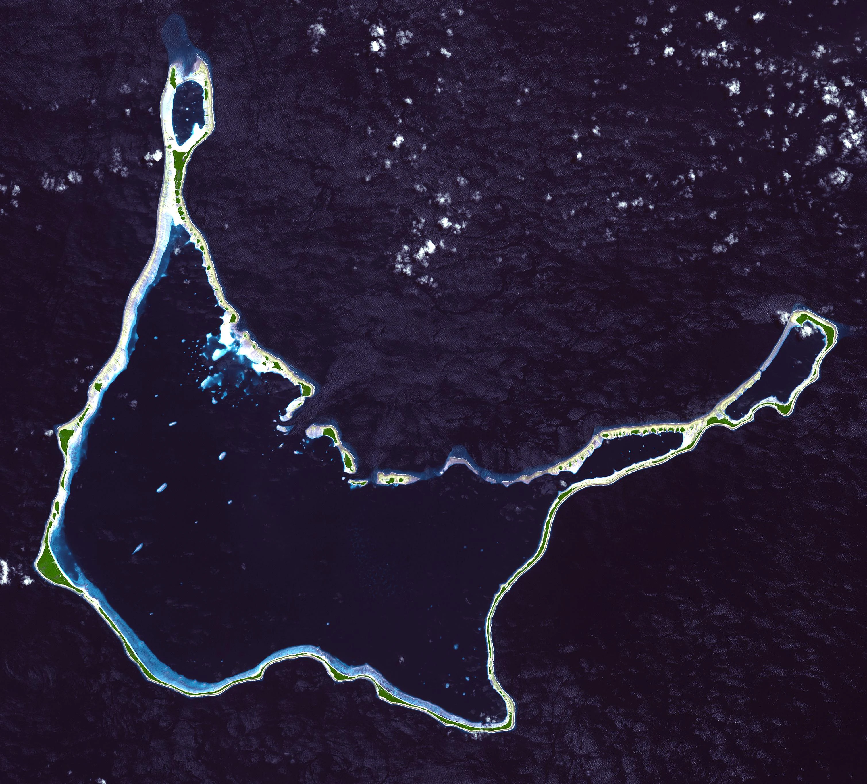
Top-down satellite view of the Arno Atoll, showing its ring of coral islands and internal lagoons set against the deep blue Pacific Ocean.
Satellite view of the Arno Atoll in the Marshall Islands.

Arno Atoll history and protected-area timeline

Arno Atoll's modern political history follows the broader pattern of the Marshall Islands under successive outside powers. Germany claimed the atoll along with the rest of the Marshall Islands in 1885, during the late nineteenth-century wave of European colonial assertions in the Pacific.

After World War I, Arno came under the South Seas Mandate administered by the Empire of Japan. Following Japan's defeat in World War II, control of the atoll passed to the United States, which administered Arno as part of the Trust Territory of the Pacific Islands. The atoll has been part of the independent Republic of the Marshall Islands since the country's independence in 1986.

Within the Marshall Islands, Arno has also been shaped by wider Pacific events. The popularity of the Kili Bag, woven by Arno women and named after Kili Island, ties the atoll's craft tradition to the displacement of the Bikini community after US nuclear weapons testing, an association that has given Arno's textile culture a broader symbolic role across the Marshallese world.

Arno Atoll landscape and geographic character

Arno Atoll is a low-lying coral atoll in the North Pacific, rising only a few meters above sea level at its highest point. Its 133 islands form a ring around an extensive interior lagoon system, and the atoll's landmass is dwarfed by the waters it encloses, particularly the main lagoon, which covers roughly 339 square kilometers.

The atoll's defining landscape feature is its triple-lagoon structure. Rather than one continuous body of water, the interior is divided into a large central lagoon and two smaller lagoons to the north and east, creating distinct hydrological zones separated by reef and islet segments. This makes Arno's reef ring unusually segmented for a Pacific atoll.

The individual islets of Arno are small and low, supporting coconut palms and other typical Marshallese atoll vegetation, and the surrounding ocean waters and lagoons carry the visual weight of the landscape. The atoll's beauty lies less in dramatic topography and more in the layered geography of reef, islet, and lagoon.

Arno Atoll ecosystems, habitats, and plant life

As a low-lying Pacific coral atoll, Arno's natural environment is shaped by the interplay of reef, lagoon, and small vegetated islands. The atoll's vegetation reflects typical Marshallese atoll flora, dominated by coconut palms and other drought- and salt-tolerant species adapted to thin sandy soils on raised coral substrate. The three-lagoon structure strongly influences the local marine environment, partitioning habitats and ecological conditions across the atoll's interior.

The lagoons and surrounding reef waters support a range of marine life typical of Ratak Chain atolls, while the narrow, low land masses limit terrestrial ecosystems to coastal strand vegetation and small pockets of interior growth. Arno's ecological identity is therefore primarily a marine and reef one, with the reef ring and lagoon system being the dominant natural features of the atoll rather than inland forest or mountain habitats.

Arno Atoll wildlife and species highlights

Arno Atoll's wildlife is dominated by its marine and reef environments rather than terrestrial species. The reef ring and interior lagoons provide habitat for the reef fish, pelagic species, and typical Pacific atoll marine fauna found elsewhere in the Ratak Chain, while the small land area limits the diversity of inland fauna.

The atoll also reflects the broader Marshallese environment in which seabirds play a significant role, and its coastal and lagoon habitats support the usual assemblage of shorebirds and waders associated with low coral islands. As with many atolls in the region, the marine ecosystem is the heart of Arno's wildlife profile.

Arno Atoll conservation status and protection priorities

While Arno Atoll is not typically described as a formal protected-area reserve, its ecological value lies in the integrity of its reef and lagoon system, including the rare triple-lagoon structure that distinguishes it from most Pacific atolls. The atoll's marine environments contribute to the broader health and biodiversity of the Ratak Chain, which faces pressures common to low coral islands across the Marshall Islands, including sea-level rise, episodic bleaching risk, and coastal erosion.

The limited terrestrial development on Arno and the small, dispersed population help preserve the atoll's reef-sand-islet structure, and traditional uses of lagoon and reef resources continue to play a central role in how Arno's natural systems are managed at the community level.

Arno Atoll cultural meaning and human context

Arno Atoll sits within a strong Marshallese cultural tradition shaped by atoll living, weaving, canoe-based seafaring, and community-based resource management. Its people have a particularly visible cultural profile in the wider Marshall Islands due to two widely recognized specialties.

First, Arno communities are known for copra production, an activity that has long been a backbone of atoll economies in the Marshall Islands and continues to shape daily life in the atoll's villages. Second, Arno women are renowned across the country for weaving the Kili Bag, a handwoven handbag named after Kili Island, the atoll to which the people of Bikini were resettled following US nuclear testing. The bag carries both practical and symbolic meaning within Marshallese society.

Arno is also said to have hosted a traditional "love school," a cultural institution associated with Marshallese social life. Together with its proximity to Majuro and its network of inhabited islets such as Ajeltokrok, Kobjeltak, Rearlaplap, Langor, and Tutu, Arno forms an important node within the cultural geography of the Marshall Islands.

Top sights and standout views in Arno Atoll

Arno Atoll's standout feature is its rare triple-lagoon geography, a structure that distinguishes it among Pacific atolls and gives its reef system a distinctive three-part character. Its closeness to Majuro, only about 20 kilometers away and visible on clear days from the capital, anchors it firmly within the lived geography of the Marshall Islands despite its small land area.

The atoll is also notable for its cultural vibrancy, from copra production and Kili Bag weaving to its network of inhabited islets, and for the way its small population sustains the traditions, crafts, and community life that define life on a Marshallese atoll.

Best time to visit Arno Atoll

Arno Atoll sits in the equatorial North Pacific, where the climate is warm and relatively stable year-round. Most of the Marshall Islands experience a wetter season associated with the broader Pacific tropical cyclone period, typically running from roughly mid-year into the later months, and a comparatively drier period outside of that window.

Because Arno is so close to Majuro, climate considerations are similar to those of the capital, with tropical heat and humidity throughout the year. For visitors, calmer seas and drier weather outside the main rainy season tend to be more comfortable for boat-based exploration of the atoll's reef, islands, and lagoons, while the atoll's coastal scenery and lagoon views remain appealing through much of the year.


Monthly climate preview

Long-term temperature averages and monthly precipitation records for Arno Atoll

Arno Atoll Climate Normals and Measured Monthly Weather Patterns

Arno Atoll maintains a consistent thermal regime accompanied by recorded monthly precipitation variations throughout the year. Reviewing the complete twelve-month normals provides detailed insight into long-term climate behavior across the representative location.
Annual mean28 °C
28 °C28 °C
Jan28°
Feb28°
Mar28°
Apr28°
May28°
Jun28°
Jul28°
Aug28°
Sep28°
Oct28°
Nov28°
Dec28°
Warmest month
November

28.2 °C

Coolest month
February

27.7 °C

Wettest month
October

9.2 mm/day

Driest month
February

4.7 mm/day

Park location guide

Geography guide, regional context, and park location map for Arno Atoll

Arno Atoll park geography, regions, and map view in Marshall Islands

Understand where Arno Atoll sits in Marshall Islands through a broader geographic reading of the surrounding landscape, nearby location context, and its mapped position within the national park landscape.

How Arno Atoll fits into Marshall Islands

The Marshall Islands is a sovereign island nation in Oceania, located in the Micronesia region of the Northwestern Pacific Ocean. The territory consists of 29 coral atolls and five main islands plus over 1,200 very small ones, divided across two island chains: Ratak in the east and Ralik in the west. The country gained independence from the United States in 1979 and maintains a Compact of Free Association with the US. It is notable for having the highest proportion of water to land of any sovereign state, at 98.62%.

Wider geography shaping Arno Atoll in Marshall Islands

The Marshall Islands is located in the Micronesia region of the Northwestern Pacific Ocean, west of the International Date Line and north of the equator. The territory is composed of 29 coral atolls and five main islands, plus approximately 1,220 very small islets, divided into two island chains: Ratak (eastern) and Ralik (western). Maritime boundaries are shared with Wake Island to the north, Kiribati to the southeast, Nauru to the south, and the Federated States of Micronesia to the west.

Map view of Arno Atoll

Use this park location map to pinpoint Arno Atoll in Marshall Islands, understand its exact geographic position, and read its mapped placement within the surrounding landscape more clearly.

Pigeon | © OpenStreetMap contributors

Explore protected area views, reef configurations, and low-lying island terrain.

Arno Atoll Photos and Scenery: Visualizing the Triple Lagoon Landscape

Examine detailed imagery documenting the complex lagoon systems, coral reefs, and island vegetation defining Arno Atoll. Visual records reveal the unique geography of this Pacific atoll, highlighting the interplay between ocean waters and reef segments.

Top-down satellite view of the Arno Atoll, showing its ring of coral islands and internal lagoons set against the deep blue Pacific Ocean.

Park atlas

Compare regional reef ecosystems and connected North Pacific protected areas

Exploring Parks Near Arno Atoll and Surrounding Protected Island Landscapes

Browsing other protected areas near Arno Atoll reveals shared coral atoll geographies and complex lagoon systems across the region. Extending the study of regional park terrain provides deeper insight into isolated marine habitats and low coral island environments.
A watercolor painting showing a panoramic view of soft, green rolling hills, a cluster of trees, and a calm water surface in a light, muted palette.
Protected areaMarshall Islands
About 35 km away#1 closest

West

Majuro: Mapping the Protected Coral Atoll Landscapes and Island Geography of the Marshall Islands

Regional atoll atlas and protected lagoon geography.

Majuro serves as the primary administrative and geographic anchor within the Marshall Islands. This detailed mapping showcases the atoll's signature structure, characterized by 64 narrow islets enclosing a massive, sheltered 295 square kilometer lagoon. Delve into the specific landforms and regional marine geography that define this Pacific protected environment.

Area
9.7 km²
Relief
Lowland
Climate
Tropical
Access
Moderate access
Protected areaMarshall Islands
About 108 km away#2 closest

South

Mili Atoll Protected Area: Geographic Boundaries and Marshall Islands Landscape Context

Mapped coral atoll terrain in the Ratak Chain

Mili Atoll represents a complex protected landscape in the central Pacific, defined by its massive lagoon and distributed ring of 92 islets. Gain a deeper understanding of its physical geography, including tidal reef flats, low-lying coral formations, and the enduring historical artifacts that shape the contemporary environment of this significant Marshall Islands site.

Area
14.9 km²
Relief
Lowland
Climate
Tropical
Access
Remote access
Nature reserveMarshall Islands
About 261 km away#3 closest

Southwest

Jaluit Atoll Nature Reserve: Protected Coral Landscapes in the Marshall Islands

Coastal reef and lagoon geography of the Ralik Chain

Jaluit Atoll constitutes a sprawling nature reserve in the Marshall Islands, characterized by its kite shaped lagoon and 91 low lying coral islets. As a recognized Ramsar wetland site, this protected area offers a deep look into Pacific atoll structure and the interplay between marine conservation and historical heritage. The atoll remains a central geographic feature of the Ralik Chain.

Area
11.34 km²
Established
2004
Relief
Lowland
Climate
Tropical
Protected areaMarshall Islands
About 408 km away#4 closest

Northwest

Ailuk Atoll Protected Area: Geography and Mapped Coral Landscapes in the Marshall Islands

Pacific atoll terrain, lagoon systems, and island geography

Study the geographic composition of Ailuk Atoll, featuring its classic ring of coral islets, deep-water reef passes, and vast central lagoon. This protected area offers insight into the subsidence-driven formation of Marshallese island chains and the enduring human reliance on traditional maritime navigation within a fragile Pacific ecosystem.

Area
5.4 km²
Relief
Lowland
Climate
Tropical
Access
Remote access
Watercolor painting of a landscape showing a body of water surrounded by green land with trees and distant hills, with soft pink and purple washes on the sides
Protected areaMarshall Islands
About 421 km away#5 closest

Northwest

Likiep Atoll: A Mapped Protected Area in the Marshall Islands Ratak Chain

Coral atoll geography and historical colonial landscape features

Likiep Atoll consists of 65 islands encircling a 424 square kilometer lagoon. As a protected area in the Marshall Islands, it offers insight into low lying atoll topography, unique marine environments, and the cultural remnants of successive colonial administrations.

Area
10.26 km²
Relief
Lowland
Climate
Tropical
Access
Remote access
Protected areaMarshall Islands
About 428 km away#6 closest

West

Namdrik Atoll Protected Area: Geography and Coastal Ecosystems in the Marshall Islands

A remote Ramsar-recognized coral atoll and marine wetland.

Namdrik Atoll is a distinctive coral atoll within the Ralik Chain of the Marshall Islands, recognized for its exceptional mangrove forests and protected marine ecosystems. This area consists of two wooded islands enclosing a large lagoon without navigable passes, creating an isolated habitat for sea turtles and diverse reef life. Explore the geography of this small, ecologically significant protected land that represents the unique environmental character of the central Pacific.

Area
2.8 km²
Established
2012
Relief
Lowland
Climate
Tropical
A pale, soft watercolor illustration depicting distant islands or atoll ridges across a calm lagoon, with silhouetted palm trees in the foreground on the left and right.
Protected areaMarshall Islands
About 473 km away#7 closest

Northwest

Kwajalein Atoll Protected Area and Marshall Islands Geographic Landscape Mapping

Pacific coral atoll structure and lagoon geography

Kwajalein Atoll represents a mature coral formation encompassing an immense lagoon within the Ralik Chain. The landscape consists of low-lying islets and interconnected reef structures that define the maritime geography of the Marshall Islands. This assessment provides a focus on the structural, mapped, and physical attributes that distinguish this protected site within the wider Pacific regional context.

Area
16.4 km²
Relief
Lowland
Climate
Tropical
Access
Highly restricted
Protected areaMarshall Islands
About 595 km away#8 closest

North

Bikar Atoll Protected Area: Geographic Overview of a Remote Marshall Islands Coral Atoll

A pristine, uninhabited coral sanctuary and critical Pacific marine habitat.

Bikar Atoll is a remote, diamond-shaped coral ring located in the Ratak Chain of the Marshall Islands. Defined by its shallow lagoon, continuous reef structure, and arid islets, the atoll serves as a vital nesting site for seabirds and green turtles. This protected area remains one of the most ecologically undisturbed sites in the Pacific, offering rare insight into natural atoll morphology and island conservation.

Area
0.5 km²
Established
2025
Relief
Lowland
Climate
Tropical

Common questions about visiting, size, designation, and location context for Arno Atoll

Arno Atoll FAQs for park facts, access, geography, and protected area context

Find quick answers about Arno Atoll, including protected-area facts, park geography, trail and visitor context, and how the park fits into its surrounding country and regional landscape.
MoriAtlas Explorer

Continue Your Protected Areas Search Across the Global Atlas

Deepen your exploration by continuing the structured search for national parks and protected areas worldwide. Utilize the comprehensive filtering capabilities to compare different conservation landscapes and refine your understanding of global park geography. Discover more about the distribution and characteristics of protected natural areas.

Global natural geography