

Mori Atlas logo
Nature reserveÅsted Ådal

Tracing the diverse habitat mosaic and ice age geological formations within this protected northern valley.

Åsted Ådal Nature Reserve: Mapped Protected Landscapes and Glacial Valley Geography in Nordjylland, Denmark

Åsted Ådal is a distinct protected landscape in northern Jutland, encompassing a classic glacial erosional valley carved through moraine hills and post-glacial lake deposits. As a recognised Natura 2000 EU habitat area, the site supports a compact, high-density mosaic of dry heathland, wet meadows, fens, and woodland. This geographic exploration of the valley reveals how glacial meltwater processes created the sharp environmental gradients that define the surrounding Nordjylland terrain.

glacial valleyNatura 2000EU habitat areaheathlanddry grasslandfen

Åsted Ådal

Nature reserve

Park overview

Structured park overview, official facts, and landscape profile for Åsted Ådal

Åsted Ådal park facts, protected area profile, and essential visitor context

Review the core facts for Åsted Ådal, including designation, size, terrain, visitor scale, habitats, and operating context in one park-focused overview.

About Åsted Ådal

Åsted Ådal lies in the northern part of Jutland, within easy reach of the coastal town of Frederikshavn and the small settlement of Gærum. It is a privately owned parcel of land covering roughly 124 hectares, but despite its private ownership it is formally protected under Danish conservation legislation (fredet). The site forms part of a broader Natura 2000 designation that links it ecologically and administratively to the neighbouring Bangsbo Ådal and the surrounding dry grassland areas of the northern Jutland coast.

Geologically, the area is shaped by the events of the last ice age. The valley itself is an erosionskløft, a glacial meltwater and post-glacial erosional valley, cut through moraine ridges and through fine-grained sediments originally deposited on the floor of glacial lakes. Above these lie marine or glaciomarine sediments from the ice sea (Ishav) that covered northern Jutland in the period immediately after the ice retreated. The result is a landscape in which slopes of glacial till alternate with flatter areas of silt, clay, and sand, producing sharply differing soil conditions over very short distances.

Hydrologically, the valley is drained by the stream Åsted Å, whose flow sustains the wet meadows, fens, swamps, and boggy ground that line the valley floor. These waterlogged habitats contrast strongly with the dry heathland on the sandy ridges and the dry grassland, or overdrev, that stretches across the higher slopes. A central theme of Åsted Ådal is therefore the close proximity of very different habitats within a single small valley system: waterlogged and dry, acidic and calcareous, open and lightly wooded.

Quick facts and research context for Åsted Ådal

Location: northern Jutland, Denmark, about 6 km west of Gærum and 10 km from Frederikshavn. Area: approximately 124 hectares, plus the neighbouring Fauerholt Hede, forming a combined area of around 136 hectares. Ownership: privately owned, but protected under Danish conservation law. Status: designated EU habitat area within the Natura 2000 network, site 8 (Åsted Ådal, Bangsbo Ådal and surrounding dry grasslands). Landscape: a glacial valley with stream, cutting through moraine hills, ice lake sediments, and post-glacial ice sea deposits. Habitats: dry heath, wet meadow, fen, swamp, marshy ground, dry grassland, and forest. Wildlife profile: roughly 58 recorded bird species, rich butterfly fauna, plus roe deer, foxes, mice and other small mammals.

Protection and recognition

Terrestrial protected area conservation records and Natura 2000 data.

Åsted Ådal Protection Status and International Recognition Records

Conservation records detail the terrestrial protection status and official Natura 2000 designations established for Åsted Ådal. Structured facts outline international recognition sources and management scope associated with the protected area.

International recognition

Protection details

Protection scope
Terrestrial
Transboundary protection
No
Park context

Deeper park guide and search-rich context for Åsted Ådal

Åsted Ådal history, landscape, wildlife, and travel context

Explore Åsted Ådal through its history, landscape character, ecosystems, wildlife, conservation priorities, cultural context, and seasonal travel timing in a structured park guide built for atlas discovery and search intent.

Why Åsted Ådal stands out

Åsted Ådal is best known for being a compact but ecologically rich glacial valley that concentrates a remarkable number of habitats within a small area of northern Jutland. The combination of dry heathland on the upper valley slopes, fens and wet meadows along the stream corridor, and dry grasslands on the surrounding moraine ridges gives the site an unusually complete habitat mosaic. The valley is also notable for its strong butterfly fauna, its breeding bird assemblage of about fifty-eight species, and its botanical diversity across heath, meadow, and woodland zones. Together with its inclusion in the Natura 2000 network as part of the larger Åsted Ådal, Bangsbo Ådal and surrounding dry grassland complex, these features make the site a recognised reference for nature conservation in the region.
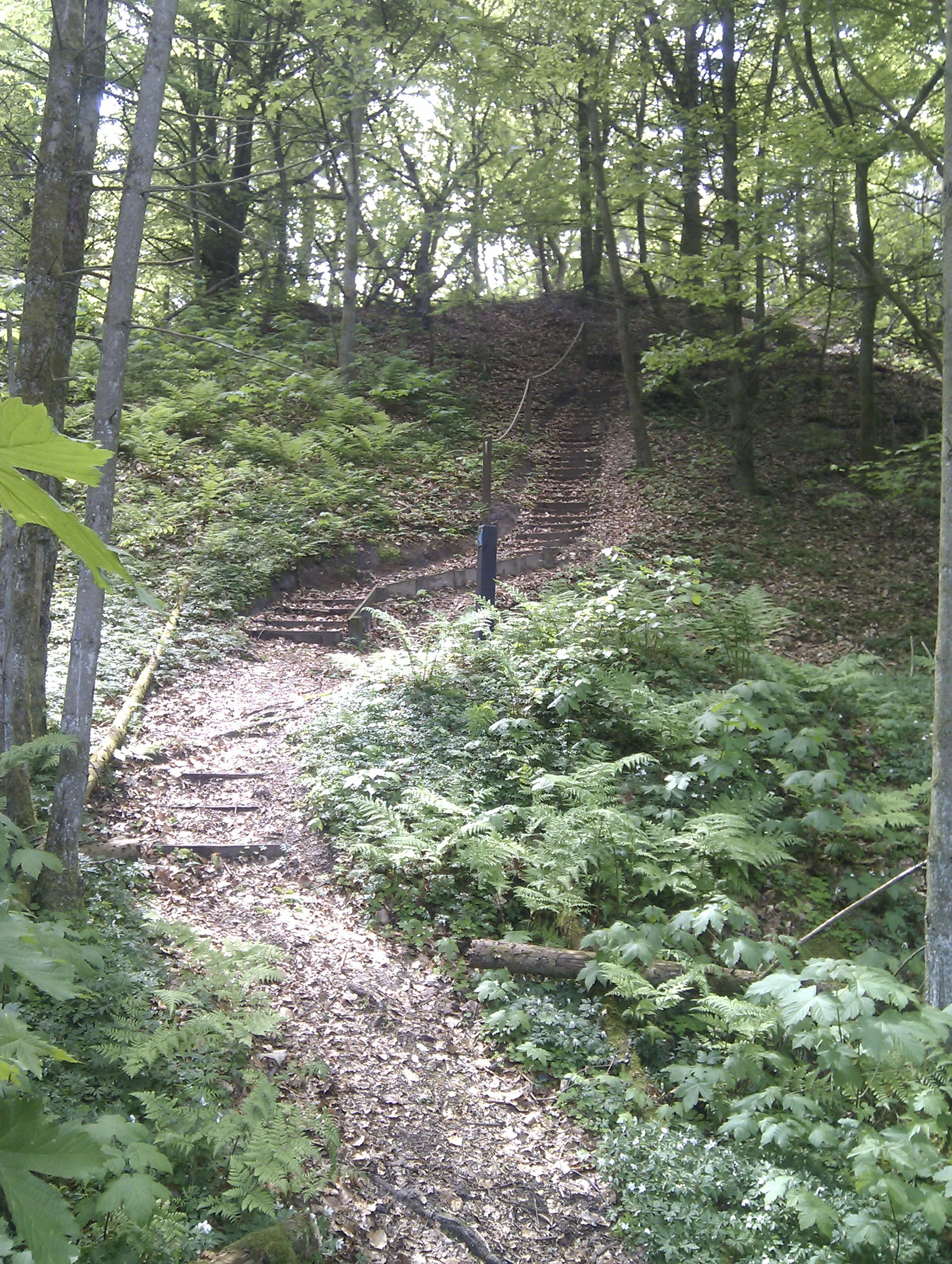
Blue trail stairs in Aasted Aadal
Stairs on the blue trail in Aasted Aadal near Frederikshavn.

Åsted Ådal history and protected-area timeline

The landform history of Åsted Ådal is rooted in the last ice age, when ice, meltwater, glacial lakes and the post-glacial ice sea collectively shaped northern Jutland. The valley itself was cut into moraine hills and into sediment layers originally deposited in glacial lake basins, then modified by marine processes when the ice sea covered the region immediately after deglaciation. These geological conditions laid the foundation for the unusual diversity of habitats seen today, as different soil types, slopes, and moisture regimes were established across the same small area.

In more recent decades, the area's biological importance has been formally recognised. It was protected under Danish nature conservation law (fredet), and it was subsequently designated an EU habitat area within the Natura 2000 network. As part of Natura 2000 area 8, Åsted Ådal was linked with the adjacent Bangsbo Ådal and the surrounding dry grassland areas into a single internationally recognised habitat complex spanning roughly 136 hectares together with the neighbouring Fauerholt Hede. This formal recognition reflects the long-running interest in the area by Danish naturalists, who have documented an extraordinarily diverse flora and a rich bird, mammal, and insect fauna within this small valley.

Åsted Ådal landscape and geographic character

Åsted Ådal is essentially a long, narrow erosional valley carved into a gently undulating moraine landscape. The valley walls expose glacial lake sediments and, higher up, the layered deposits left by the post-glacial ice sea. The result is a terrain of steep slopes, flat valley bottoms, and intervening terraces, all produced by ice age processes that acted over a matter of thousands of years.

The valley floor is dominated by the meandering course of Åsted Å and its associated wet meadows, fens, swamps, and boggy patches. These low-lying areas are flanked by steeper slopes of glacial till (morænebakker), which often support woodland or dry grassland depending on slope and soil. Along the higher edges of the valley, sandy and gravelly terraces grade into open heathland (hede), continuing the habitat gradient from wet to dry.

A defining visual quality of Åsted Ådal is therefore its strong environmental contrast: at any one moment, a visitor can look from a moist meadow full of flowering geophytes up to a sun-exposed heath slope dotted with heather, and from there across to a steep slope clothed in broadleaf forest. This compact transition between very different landscape types within a single valley is one of the most characteristic features of the site.

Åsted Ådal ecosystems, habitats, and plant life

Ecologically, Åsted Ådal is notable not for being a single habitat but for packing several contrasting habitat types into a very small area. The valley floor supports wet meadow, fen, swamp, and marshy ground, where soils remain saturated by the stream Åsted Å for much of the year. These conditions allow moisture-loving species to coexist with drier-loving vegetation only a few metres away.

On the valley slopes and higher terraces, conditions shift dramatically. Dry grassland, or overdrev, occupies parts of the moraine ridges where grazing or historical land use has kept the vegetation open. On the sandier, more acid terraces, true heathland vegetation (hede), with heather and related species, becomes dominant. Between these open habitats, pockets of forest, particularly broadleaf woodland, provide shaded habitats with their own distinctive flora.

The result is a habitat mosaic where fen species such as marsh marigold and bogbean sit close to dry heathland species like cowberry and honeybell. Because these transitions happen over very short distances, Åsted Ådal supports an unusually high density of plant species for its size and a correspondingly diverse insect fauna, particularly butterflies, which depend on these varied conditions for nectar sources and larval host plants.

Åsted Ådal wildlife and species highlights

Åsted Ådal sustains a rich wildlife profile for its modest size. Around fifty-eight bird species have been recorded in the area, reflecting the diversity of habitats available within a small space. Open heath and dry grassland provide breeding and feeding habitat for species such as red-backed shrike, while the woodland and forest edges support woodpeckers and raptors like sparrowhawk and goshawk. Wet areas within the valley attract wading birds and other wetland specialists such as jack snipe, and the surrounding airspace and woodland edges are used by larger birds of prey including red kite.

Mammals are also well represented. The valley holds populations of roe deer in the more wooded sections, foxes that patrol the margins between forest and open ground, and a thriving population of mice and other small rodents that sustain the wider predator community. This small-mammal abundance in turn supports the raptors and owls that breed in and around Åsted Ådal.

The insect fauna is one of the site's standout elements. The mix of dry and wet habitats, combined with a rich flowering flora, makes Åsted Ådal particularly notable for butterflies. Species associated with dry grasslands and heathland, as well as those tied to wetland margins and meadows, are all present, creating a butterfly community that mirrors the valley's general habitat diversity.

Åsted Ådal conservation status and protection priorities

Åsted Ådal matters from a conservation perspective because it concentrates several habitat types of high European importance into a very small, well-defined area. The site is formally protected under Danish law and is recognised internationally through its inclusion in the Natura 2000 network as part of area 8 (Åsted Ådal, Bangsbo Ådal and associated dry grasslands), which also incorporates the neighbouring Fauerholt Hede.

Its conservation value lies in the combination of habitat types it protects. Dry heathland, dry grassland, fen, marsh, woodland, and meadow habitats each have their own conservation significance under the EU Habitats Directive, and the close proximity of these habitats within a single valley makes Åsted Ådal an unusually efficient area for biodiversity conservation. Wetland and meadow habitats in particular benefit from continued support of the natural hydrology of Åsted Å, while dry grassland and heathland depend on the absence of intensive agricultural conversion or afforestation.

The site's private ownership, combined with its formal protected status, illustrates the way Danish conservation practice integrates privately owned land into national and European habitat networks. Because the land has retained its varied character through the decades, it continues to function both as a refuge for native flora and fauna in a heavily cultivated region and as a reference point for understanding northern Jutland's post-glacial ecological heritage.

Åsted Ådal cultural meaning and human context

While Åsted Ådal is a natural area rather than a built heritage site, it sits within a landscape of long-established rural and natural land use in northern Jutland. The surrounding region has historically been shaped by agriculture, grazing, and small communities such as Gærum, and the pattern of dry and wet habitats in the valley reflects that long interaction between human land use and natural processes. The dry grasslands (overdrev), in particular, are a habitat type created and maintained by traditional grazing, and their presence in Åsted Ådal underlines the area's long cultural association with low-intensity agricultural use.

The valley's name itself, like that of nearby Bangsbo Ådal, refers to the stream (Åsted Å) that runs through it, a typical pattern in Danish topography where small valleys are named for their streams or for nearby farms and villages.

Top sights and standout views in Åsted Ådal

A glacial meltwater valley with an unusually complete habitat mosaic (heath, fen, meadow, dry grassland, woodland) compressed into roughly 124 hectares.

Inclusion in the Natura 2000 network as part of a larger complex linking Åsted Ådal, Bangsbo Ådal and surrounding dry grasslands; formally protected under Danish conservation law.

Strong butterfly fauna, with species associated with both dry and wet habitats documented within the same valley system.

Approximately 58 recorded bird species, including raptors such as red kite, goshawk and sparrowhawk, plus heathland specialists like red-backed shrike.

Botanically rich across all main habitats, from wetland forbs in fens and meadows through woodland geophytes on the slopes to dry heath and grassland specialists on the moraine ridges.

Best time to visit Åsted Ådal

The character of a visit to Åsted Ådal changes with the seasons in ways that reflect the valley's habitat diversity. Late spring and early summer are typically the most rewarding periods for flowering plants, when meadows, fens, and dry grasslands all carry their characteristic blooms, and when butterfly activity is at its peak. This is also a productive season for bird observation, because breeding activity is high and many of the valley's species are easiest to see in settled territory.

Late summer and early autumn emphasise a different aspect of the site, with heathland coming into flower and a shift in insect activity toward late-season nectar sources. Winter and early spring, when deciduous trees are bare, can be good for viewing the underlying glacial landforms and for observing woodland birds more easily, though overall biodiversity richness is lower at this time. Because the area is a glacial valley with wet ground in the bottom, conditions underfoot can be soft in winter and spring, while dry slopes and heathland remain accessible at all times of year.
Monthly climate preview

Long-term representative coordinate records for monthly temperature and precipitation in Nordjylland

Åsted Ådal Climate Normals and Measured Annual Temperature Rhythm

Representative coordinate records show measured temperature swings from sub-zero winter minimums to warm summer maximums alongside consistent monthly precipitation across the year. Reviewing the complete twelve-month profile provides deeper analytical context on long-term climate normals for Åsted Ådal.
Annual mean9 °C
1 °C17 °C
Jan
Feb
Mar
Apr
May11°
Jun14°
Jul17°
Aug17°
Sep14°
Oct10°
Nov
Dec
Warmest month
August

17.2 °C

Coolest month
February

1.5 °C

Wettest month
October

3.3 mm/day

Driest month
April

1.7 mm/day

Park location guide

Geography guide, regional context, and park location map for Åsted Ådal

Åsted Ådal park geography, regions, and map view in Denmark

Understand where Åsted Ådal sits in Denmark through a broader geographic reading of the surrounding landscape, nearby location context, and its mapped position within the national park landscape.

How Åsted Ådal fits into Denmark

Denmark is a constitutional monarchy and Nordic country in Northern Europe. It is the southernmost of the Scandinavian countries, bordering Germany to the south, Norway to the north, and Sweden to the southwest. The country consists of the Jutland peninsula and an archipelago of islands, with Copenhagen as its capital and largest city. Denmark has a population of over 6 million and is characterized by flat, arable land, sandy coasts, and a temperate climate.

Wider geography shaping Åsted Ådal in Denmark

Denmark occupies the Jutland peninsula and roughly 406 islands in Northern Europe. It is situated between the North Sea to the west and the Baltic Sea to the east. The country borders Germany to the south and is connected to Sweden via the Øresund Bridge. Denmark is predominantly flat terrain with low elevation, the highest point being Møllehøj at 170.86 meters.

Map view of Åsted Ådal

Use this park location map to pinpoint Åsted Ådal in Denmark, understand its exact geographic position, and read its mapped placement within the surrounding landscape more clearly.

Pigeon | © OpenStreetMap contributors

Location context for Åsted Ådal

Nordjylland

Visualizing glacial valley terrain, rare habitats, and conservation zones

Åsted Ådal Photos and Protected Landscape Scenery in Northern Jutland

Visual records reveal the distinctive glacial valley terrain and diverse habitats preserved within Åsted Ådal. Examining authentic park imagery helps observers understand complex transitions between wet meadows, steep moraine slopes, and open heathland.

Blue trail stairs in Aasted Aadal

Aasted Aadal

Park atlas

Compare regional glacial valleys and connected nature reserves across northern Jutland

Explore Other Parks Near Åsted Ådal And Surrounding Protected Landscapes

Visitors exploring Åsted Ådal can continue browsing nearby protected areas and connected glacial valley habitats across northern Denmark. Comparing adjacent reserves reveals broader regional patterns in coastal moraine terrain, wetland ecosystems, and conservation networks.
Protected areaRegion Nordjylland
3.7 km away#1 closest

North

Jerup Hede, Råbjerg og Tolshave Mose: Protected Area and Ridge and Pool Terrain

Geographic landscape overview in Region Nordjylland

Jerup Hede, Råbjerg og Tolshave Mose contains the largest continuous area of ridge and pool landscapes in Denmark. The site features an undulating terrain of hummocks and wet hollows typical of intact raised bogs, transitioning from inland heaths to coastal dune formations near the Skagerrak coast. It remains an essential site for studying Northern European mire ecosystems and wetland habitat patterns.

Area
40.24 km²
Relief
Lowland
Climate
Temperate
Access
Access unknown
Nature reserveRegion Nordjylland
About 12 km away#2 closest

Northeast

Natura 2000-område nr. 4 Hirsholmene, havet vest herfor og Ellinge Å's udløb: Mapping Protected Landscapes

A dual marine and coastal nature reserve in Region Nordjylland

Analyze the marine and coastal topography of this significant Natura 2000 site. The mapped region spans from the Kattegat bubble reefs to the freshwater influence of the Ellinge Å outlet, offering a clear perspective on the distribution of sandbanks, island groups, and terrestrial habitats that characterize this protected Danish geography.

Area
95.33 km²
Established
2011
Relief
Lowland
Climate
Temperate
Nature reserveRegion Nordjylland
17 km away#3 closest

Southeast

Solsbæk Nature Reserve: Geographic Profile and Protected Coastal Dune Landscapes

A rare calcareous dune ecosystem in Region Nordjylland, Denmark.

Solsbæk is a designated nature reserve on the Vendsyssel coast, notable for its concentrated series of coastal dune habitats. Formed by lime-rich shell sand, the landscape sustains a diverse array of vegetation including grey and green dunes, juniper scrub, and dune heath. This compact site provides a vital reference for understanding the ecological structure and botanical variety of protected coastal lands in northern Denmark.

Area
0.33 km²
Established
1972
Relief
Lowland
Climate
Temperate
Protected areaRegion Nordjylland
About 23 km away#4 closest

Northwest

Natura 2000-område nr. 5 Uggerby Klitplantage og Uggerby Å's udløb Protected Area

Coastal dune and riverine landscape mapping in Region Nordjylland

Explore the varied terrain of this 717-hectare site featuring a complete sequence of green dune habitats, fresh water slacks, and the Uggerby Å river estuary. The area displays a dense concentration of coastal geomorphology and protected plant species, providing a deep look into the natural landscape character of the northern Danish coast along the Skagerrak.

Area
7.17 km²
Relief
Lowland
Climate
Temperate
Scope
Terrestrial
Nature reserveLæsø Municipality
27 km away#5 closest

East

Nordre Rønner: Protected Island Landscapes and Geographic Mapping of Læsø Municipality

Remote coastal nature reserve and marine habitat within the Danish Kattegat sea

Nordre Rønner represents a significant cluster of islets in the Kattegat, showcasing the interplay of post-glacial land rise and coastal ecology. Managed within Læsø Municipality, these eleven hectares of protected land include essential nesting grounds for terns and harbor seals. This resource outlines the physical geography, mapped island connections, and the status of this unique maritime nature reserve.

Area
0.11 km²
Relief
Lowland
Climate
Temperate
Access
Moderate access
Nature reserveRegion Nordjylland
32 km away#6 closest

West

Kærsgård Strand, Vandplasken og Liver Å Nature Reserve: Geographic and Landscape Atlas

Protected coastal dune systems and inland wetland geography

Examine the protected landscape of Kærsgård Strand, Vandplasken og Liver Å, a key Danish nature reserve characterized by complex dune hydrology, clear-water lake systems, and diverse botanical habitats. This site serves as a vital reference for northwestern European calcareous ecology and wetland preservation.

Area
4.42 km²
Established
2011
Relief
Lowland
Climate
Temperate
Nature reserveLæsø
About 42 km away#7 closest

East

Bovet Nature Reserve and Coastal Habitat Geography in Læsø, Denmark

A protected coastal corridor of heathland and salt marsh

Bovet is a 65-hectare nature reserve on the island of Læsø that safeguards a pristine 2.5 km stretch of Danish coastline. Characterized by a flat, open topography of heath, beach meadow, and reedbed, the site is defined by its sweeping views across Bovet Bugt and scattered glacial erratics. Its status as a bird protection area and Ramsar wetland highlights its importance as a habitat for breeding and resting waders within the Kattegat region.

Area
0.65 km²
Established
1964
Relief
Lowland
Climate
Temperate
Nature reserveLæsø
About 47 km away#8 closest

East

Østdelen af Læsø Nature Reserve: Mapped Coastal Geography and Protected Danish Island Terrain

Explore active dune systems, beach ridges, and coastal heath-mire habitats

Østdelen af Læsø features a distinct interplay of coastal geology and traditional heathland vegetation across its 266 hectares. The reserve spans from the elevated Danzigmand dunes to the dynamic, growing barrier islands of Store Knot and Lille Knot, offering a comprehensive look at Denmark's shifting coastal margins and vital seabird nesting grounds.

Area
2.66 km²
Established
1963
Relief
Lowland
Climate
Temperate

Common questions about visiting, size, designation, and location context for Åsted Ådal

Åsted Ådal FAQs for park facts, access, geography, and protected area context

Find quick answers about Åsted Ådal, including protected-area facts, park geography, trail and visitor context, and how the park fits into its surrounding country and regional landscape.
MoriAtlas Explorer

Continue Your Protected Areas Search Across the Global Atlas

Deepen your exploration by continuing the structured search for national parks and protected areas worldwide. Utilize the comprehensive filtering capabilities to compare different conservation landscapes and refine your understanding of global park geography. Discover more about the distribution and characteristics of protected natural areas.

Global natural geography