Mori Atlas logo
Nature reserveAtherstone Nature Reserve

Mapping the protected savannah plains and diverse grasslands of northern South Africa

Atherstone Nature Reserve: A Protected Bushveld and Savannah Landscape in Limpopo Province

(Atherstone Collaborative Nature Reserve)

Atherstone Nature Reserve stands as a significant protected area within the Limpopo province, covering roughly 23,500 hectares of diverse northern bushveld terrain. This expansive reserve is defined by its unique mosaic of open savannah plains and Kalahari-style grasslands, providing a continuous, high-visibility habitat for large mammal populations. Collaborative management between provincial authorities and private landowners preserves this vital ecological network, offering a clear view into the regional geography and conservation strategies of South Africa.

savannahbushveldKalahari grasslandsLimpopocollaborative reservebig game

Atherstone Nature Reserve

Nature reserve

Park overview

Structured park overview, official facts, and landscape profile for Atherstone Nature Reserve

Atherstone Nature Reserve park facts, protected area profile, and essential visitor context

Review the core facts for Atherstone Nature Reserve, including designation, size, terrain, visitor scale, habitats, and operating context in one park-focused overview.

About Atherstone Nature Reserve

Atherstone Nature Reserve sits in the northern reaches of South Africa's Limpopo province, close to the small community of Dwaalboom. The reserve spans roughly 23,500 hectares of savannah plains, where the landscape transitions between bushveld thickets and the more open, grass-dominated character of Kalahari-influenced vegetation. This wide ecological setting gives Atherstone the visual openness and habitat diversity typically associated with the country's premier lowveld and Kalahari-border reserves, supporting both browsing and grazing species across a continuous landscape.

The reserve is jointly managed by the provincial conservation authority, LEDET, and a group of private landowners, making it a genuine collaborative protected area rather than a strictly government-run park. This management model reflects a broader South African conservation trend in which former farmland has been consolidated into larger, ecologically functional game reserves. Within Atherstone, this approach enables wildlife to move across substantial ranges while benefitting from coordinated conservation oversight.

Wildlife is the central feature of the Atherstone experience. The reserve supports a strong representation of South Africa's signature game species, from elephants and rhinoceros to giraffes, zebras, and numerous antelope species. The birdlife is equally diverse, with grassland, woodland, and water-associated species all documented. Together, the reserve's landscape character, large mammal populations, and collaborative management make it a meaningful destination for safari-style exploration within Limpopo.

Quick facts and research context for Atherstone Nature Reserve

Atherstone Nature Reserve, formally known as the Atherstone Collaborative Nature Reserve, is located in Limpopo province near Dwaalboom in northern South Africa. It covers around 23,500 hectares and was established as a collaborative reserve in 1994, following the original founding of Atherstone Nature Reserve in 1990. The reserve is managed jointly by the provincial conservation authority (LEDET) and private landowners, combining former farmland with continuous bushveld habitat.

Protection and recognition

Documented terrestrial conservation scope and official protected area records

Atherstone Nature Reserve Protection Status and International Recognition

Atherstone Nature Reserve maintains a documented terrestrial protection status within official conservation inventories. Official records assemble baseline management scope and designated territorial frameworks for the protected area.

Protection details

Protection scope
Terrestrial
Transboundary protection
No
Park context

Deeper park guide and search-rich context for Atherstone Nature Reserve

Atherstone Nature Reserve history, landscape, wildlife, and travel context

Explore Atherstone Nature Reserve through its history, landscape character, ecosystems, wildlife, conservation priorities, cultural context, and seasonal travel timing in a structured park guide built for atlas discovery and search intent.

Why Atherstone Nature Reserve stands out

Atherstone is best known for its expansive bushveld and Kalahari-grassland savannah scenery and its populations of large African mammals. Sightings of African bush elephants and south-central black rhinoceros are among the reserve's defining attractions, alongside giraffes, zebras, and a wide variety of antelope that thrive in the open plains habitat. The reserve is also recognized for being a collaboratively managed conservation area, where provincial conservation authorities and private landowners jointly oversee wildlife management on a landscape scale. This blend of big-game viewing, savannah scenery, and multi-stakeholder conservation gives Atherstone a distinctive identity within Limpopo's protected-area network.

Atherstone Nature Reserve history and protected-area timeline

The origin of Atherstone Nature Reserve is tied to Norman Edward Atherstone, a cattle farmer who became the first game farmer in the area. He worked to re-introduce game onto his farmland, transforming what would eventually become Atherstone Game Reserve. Atherstone never married and had no children, and in his last will he donated his farms to the former Transvaal Nature Conservation Department.

The Atherstone Nature Reserve was formally founded in 1990 on the basis of these donated lands. In 1994, the reserve was expanded and reorganized into the Atherstone Collaborative Nature Reserve, incorporating additional private farms into the protected area. Since then, management responsibility has been shared between the provincial authority, LEDET, and the participating private landowners, establishing the collaborative governance model that still defines the reserve today.

Atherstone Nature Reserve landscape and geographic character

Atherstone's landscape is defined by broad, open savannah plains that blend two distinct ecological influences: classic South African bushveld with its scattered trees, shrubs, and denser thickets, and the more arid, grass-dominated character of Kalahari grasslands. The result is a mosaic of open grazing areas interspersed with woody vegetation, giving the reserve a varied but distinctly lowveld feel.

This terrain supports the kind of visibility and openness typical of bushveld safaris, with wide horizons and regular sightings visible across the grasslands. The interplay between grassy plains and bushveld thickets creates different microhabitats across the property, allowing both grazing herbivores and more cover-dependent species to find suitable range within the same continuous landscape.

Atherstone Nature Reserve ecosystems, habitats, and plant life

Ecologically, Atherstone is anchored in the transitional zone between bushveld savannah and Kalahari-influenced grasslands of northern South Africa. The reserve's habitats support both grass-dependent grazers and mixed feeders that browse on woody vegetation, while patches of thicker bushveld provide cover and browsing opportunities for species that prefer denser habitat structure.

This habitat diversity underpins the reserve's ecological value, allowing a wide range of mammal, bird, and insect species to coexist on a single landscape. The mosaic of grassland and bushveld typical of Atherstone is characteristic of regions where the Limpopo province meets the broader arid-savannah systems stretching toward the Kalahari.

Atherstone Nature Reserve wildlife and species highlights

Atherstone hosts a substantial cross-section of South African mammal fauna, anchored by a wide range of antelope and large game species. Antelope such as impala, kudu, eland, sable antelope, steenbok, gemsbok, tsessebe, waterbuck, and both blue wildebeest and red hartebeest are part of the reserve's mammal community. Larger species, including giraffes, zebras, African buffalo, and warthogs, are also regularly present.

The reserve is particularly notable for its populations of African bush elephants and rhinoceros, including south-central black rhinoceros along with white rhinoceros, both of which are major conservation priorities in South Africa. Predators and smaller carnivores recorded at Atherstone include leopard, cheetah, caracal, brown hyena, and black-backed jackal, while common duiker, vervet monkeys, and genets round out the mammal list.

The reserve's birdlife is exceptionally diverse, including ostrich, several vulture species such as Cape vulture and white-backed vulture, martial and tawny eagles, bateleur, secretary bird, Kori bustard, hornbills, rollers, bee-eaters, kingfishers, owls, nightjars, and an array of francolins, doves, finches, and starlings. Water-associated species such as African spoonbill, hamerkop, Egyptian goose, and white-faced whistling duck are also documented, indicating seasonal or perennial wetland habitats within the reserve.

Atherstone Nature Reserve conservation status and protection priorities

Atherstone's conservation significance lies in its combined role as a refuge for large, range-dependent mammals and as a model for collaborative protected-area governance in South Africa. By protecting a continuous landscape of approximately 23,500 hectares, the reserve safeguards habitat for elephants, multiple rhinoceros populations, and a wide spectrum of antelope species, many of which require extensive space and intact vegetation communities to remain viable.

The collaborative management structure, which pairs the provincial conservation authority LEDET with private landowners, represents a significant conservation approach in modern South Africa. It demonstrates how privately owned farmland, when integrated into a single managed reserve, can be restored to functional wildlife habitat while still retaining the involvement of the original landowners. This model helps expand the effective conservation estate in Limpopo beyond strictly state-owned protected areas, contributing to broader landscape connectivity for wide-ranging species.

Atherstone Nature Reserve cultural meaning and human context

The cultural thread running through Atherstone is rooted in the figure of Norman Edward Atherstone himself. As a cattle farmer who became the region's first game farmer and reintroduced game onto his land, Atherstone represents an early chapter in the transformation of South African farmland into game reserves, a transition that has shaped much of Limpopo's modern conservation landscape.

The later inclusion of private farms into the broader reserve in 1994 reflects the wider South African practice of integrating neighbouring landowners into shared conservation initiatives, producing a reserve whose identity is shaped as much by local landowner history as by formal conservation administration.

Top sights and standout views in Atherstone Nature Reserve

Among the reserve's most distinctive highlights is its combination of bushveld and Kalahari-style savannah on a continuous 23,500-hectare landscape, giving it both scenic openness and habitat diversity. The presence of African bush elephants and both black and white rhinoceros places Atherstone among the more ecologically significant reserves in Limpopo for big-game conservation.

The reserve's collaborative management structure, jointly run by LEDET and private landowners, is itself a defining feature, making Atherstone a working example of multi-stakeholder conservation in South Africa. Its exceptional bird list, ranging from ostriches and vultures to rollers, bee-eaters, and waterbirds, adds an additional dimension that complements its mammal-focused identity.

Best time to visit Atherstone Nature Reserve

The dry winter and early spring months, broadly from May through August, are typically the most rewarding period for visiting savannah reserves in Limpopo. During this time, cooler temperatures, reduced vegetation cover, and the tendency of wildlife to congregate around remaining water sources make game viewing more productive and the bushveld scenery more open and visible.

The wetter summer months, roughly from November through March, bring lush grasslands, active birdlife, and the presence of migratory species, but also denser vegetation, higher temperatures, and more challenging game-viewing conditions. Travellers who value green scenery, breeding bird activity, and atmospheric summer landscapes may find this season rewarding, while those focused on mammal sightings often prefer the cooler dry months.
Monthly climate preview

Long-term temperature ranges and monthly precipitation data across representative terrain

Atherstone Nature Reserve Climate Normals and Annual Weather Patterns

Representative coordinate records show measured multi-year temperature variations and monthly precipitation rhythms across Atherstone Nature Reserve. Examining the complete twelve-month climatology profile reveals detailed variations in average minimum and maximum temperatures throughout the year.
Annual mean22 °C
14 °C27 °C
Jan27°
Feb26°
Mar25°
Apr21°
May18°
Jun15°
Jul14°
Aug17°
Sep22°
Oct25°
Nov26°
Dec26°
Warmest month
January

26.6 °C

Coolest month
July

14.2 °C

Wettest month
December

3.1 mm/day

Driest month
July

0 mm/day

Park location guide

Geography guide, regional context, and park location map for Atherstone Nature Reserve

Atherstone Nature Reserve park geography, regions, and map view in South Africa

Understand where Atherstone Nature Reserve sits in South Africa through a broader geographic reading of the surrounding landscape, nearby location context, and its mapped position within the national park landscape.

How Atherstone Nature Reserve fits into South Africa

South Africa is the southernmost country in Africa, spanning 1.22 million km² with a population of over 63 million. The country operates with three capital cities, Pretoria (executive), Cape Town (legislative), and Bloemfontein (judicial), and is renowned for its biodiversity, national parks, and multicultural society.

Wider geography shaping Atherstone Nature Reserve in South Africa

South Africa occupies the southernmost region of Africa, with coastline along both the Atlantic Ocean to the west and the Indian Ocean to the east. The interior features elevated plateaus including the Highveld, with the Drakensberg escarpment marking the eastern highlands. The country shares borders with Namibia, Botswana, Zimbabwe, Mozambique, Eswatini, and Lesotho.

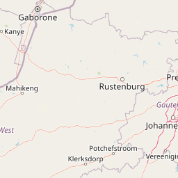
Map view of Atherstone Nature Reserve

Use this park location map to pinpoint Atherstone Nature Reserve in South Africa, understand its exact geographic position, and read its mapped placement within the surrounding landscape more clearly.

Pigeon | © OpenStreetMap contributors

Location context for Atherstone Nature Reserve

Limpopo
Park atlas

Compare adjacent savannah landscapes and regional conservation zones in northern South Africa.

Explore Parks Near Atherstone Nature Reserve and Surrounding Protected Areas

Browse nearby national parks and protected areas sharing the distinctive bushveld and Kalahari grassland terrain of Limpopo. Comparing these connected conservation landscapes offers deeper geographical insight into regional wildlife habitats.
A soft watercolor painting depicting a wide African savanna landscape with a winding stream, scattered green trees, and distant hills under a light sky.
Wildlife reserveNorth West Province
About 63 km away#1 closest

Southwest

Madikwe Game Reserve Geography: Protected Bushveld and Semi-Arid Wilderness Atlas

Wildlife reserve landscapes in North West Province, South Africa

Madikwe Game Reserve occupies a significant corridor of open savanna and rocky terrain on the edge of the Kalahari. This detail page provides insights into the park's geographic scale, its role in landscape restoration, and its position within the broader environmental context of the North West Province borderlands.

Area
750 km²
Established
1994
Relief
Upland
Climate
Arid
Biosphere reserveLimpopo
About 67 km away#2 closest

East

Waterberg Biosphere: A Protected Sandstone Massif in Limpopo Province South Africa

Geology, mapping, and ecological zones of the Waterberg range

The Waterberg Biosphere stands as a major protected region in South Africa, formed by ancient sandstone layers sculpted into mesas and deep gorges. This massif bridges ecological zones from highland savanna to riverine habitats, anchoring a network of game reserves and wilderness areas through its distinctive geological and historical landscape identity.

Area
6,540.33 km²
Established
2001
Relief
Mountain
Climate
Subtropical
National parkLimpopo Province
About 70 km away#3 closest

East

Marakele National Park: National Park Protected Landscape and Geographic Context

Explore its Limpopo Province regional setting and mapped boundaries.

Marakele National Park represents a vital protected national park within the diverse geography of Limpopo Province, South Africa. This entry provides detailed atlas-style information on its protected landscape, focusing on mapped geographic boundaries and its context within the regional natural terrain. It serves as a key resource for understanding the park's specific role as a conservation area and its place within the broader atlas of South African protected lands.

Area
670 km²
Established
1994
Relief
Mountain
Climate
Subtropical
A pale, minimalist watercolor painting depicting rolling green hills in the distance with a winding dirt path leading through grassy plains in the foreground.
National parkNorth West Province
About 82 km away#4 closest

Southeast

Pilanesberg National Park: Geologic Mapping of a South African Alkaline Ring Complex

Explore concentric volcanic terrain and protected bushveld landscapes

Pilanesberg National Park covers the eroded root of a massive 1.2 billion year old volcano. Its defining feature is a series of concentric hills and basins that rise from the flat bushveld plains of South Africa. This protected area offers a distinct geographic study in volcanic topography, featuring rocky syenite outcrops, open savanna, and varied water sources that define the ecological character of this significant regional landscape.

Area
572 km²
Established
1984
Relief
Mountain
Climate
Subtropical
Wildlife reserveLimpopo
About 117 km away#5 closest

East

Mabula Game Reserve: Protected Bushveld and Geographic Landscape Profile

Exploration of the Limpopo bushveld and wildlife habitat boundaries

Mabula Game Reserve provides a detailed look at the bushveld ecosystems of South Africa. Spanning 12,000 hectares in Limpopo, the reserve features a unique blend of rocky ridges, open savanna, and riverine woodlands. Its structural diversity creates a distinct natural corridor that serves as a focal point for understanding regional wildlife distribution and the transition zone between the Waterberg and the northern plains.

Area
120 km²
Scope
Terrestrial
Wildlife reserveLimpopo
About 121 km away#6 closest

East

Welgevonden Game Reserve: A Comprehensive Geographic Profile of a Limpopo Wildlife Haven

Mapped terrain across the Waterberg mountain bushveld

Welgevonden Game Reserve stands as a focal point for protected land discovery in South Africa. The reserve features complex geological formations, ranging from steep cliffs to open plateau grasslands. Gain insights into the physical boundaries and landscape diversity that define this significant conservation area located within the northern Limpopo province.

Area
382 km²
Relief
Mountain
Access
Access unknown
Scope
Terrestrial
Wildlife reserveNorth West Province
About 125 km away#7 closest

Southeast

Borakalalo Game Reserve: Protected Bushveld and Aquatic Landscapes in North West Province

Mapping a diverse South African wildlife reserve

Borakalalo Game Reserve features a distinct ecological setting within South Africa, combining woodland bushveld with the aquatic ecosystems of Klipvoor Dam. This protected area provides a habitat for varied mammal species and an extensive bird list, set against the backdrop of the interior plateau landscape in North West Province.

Area
130 km²
Relief
Upland
Access
Access unknown
Scope
Terrestrial
A watercolor painting showing a wide, panoramic view of rolling green and yellow hills, scattered acacia-like trees, and a distant purple mountain range under a light sky.
Nature reserveNorth West
About 127 km away#8 closest

South

Kgaswane Mountain Reserve: Map and Geographic Profile of the Magaliesberg Range

A protected nature reserve in the North West province of South Africa.

Kgaswane Mountain Reserve stands as a pivotal protected landscape within the Magaliesberg Biosphere. This atlas record provides insights into its quartzitic ridges, complex grassland and woodland ecosystems, and status as a Ramsar wetland site, offering a clear view of its geographic and conservation significance.

Area
53 km²
Established
1967

Common questions about visiting, size, designation, and location context for Atherstone Nature Reserve

Atherstone Nature Reserve FAQs for park facts, access, geography, and protected area context

Find quick answers about Atherstone Nature Reserve, including protected-area facts, park geography, trail and visitor context, and how the park fits into its surrounding country and regional landscape.
MoriAtlas Explorer

Continue Your Protected Areas Search Across the Global Atlas

Deepen your exploration by continuing the structured search for national parks and protected areas worldwide. Utilize the comprehensive filtering capabilities to compare different conservation landscapes and refine your understanding of global park geography. Discover more about the distribution and characteristics of protected natural areas.

Global natural geography