Mori Atlas logo
Nature reserveBellheimer Wald

Understanding the unique sandy terrains and alluvial fan formations of the southern Palatinate

Bellheimer Wald Nature Reserve: Mapped Protected Landscapes and Alluvial Forest Geography

(Bellheimer Wald mit Queichtal (FFH-Gebiet 6715-302))

Bellheimer Wald stands as a significant protected forest landscape within the southern Palatinate region of Rhineland-Palatinate. Situated on a broad alluvial fan created by the Queich stream, this protected area features a distinct mosaic of woodland, inland sand dunes, and semi-dry grasslands. The forest serves as a vital ecological corridor, anchoring a network of Rhine-margin protected sites between the Speyerer Wald and the Bienwald.

lowland forestalluvial faninland dunesand grasslandNatura 2000 siteHabitats Directive area

Bellheimer Wald

Nature reserve

Park overview

Structured park overview, official facts, and landscape profile for Bellheimer Wald

Bellheimer Wald park facts, protected area profile, and essential visitor context

Review the core facts for Bellheimer Wald, including designation, size, terrain, visitor scale, habitats, and operating context in one park-focused overview.

About Bellheimer Wald

The Bellheimer Wald is a substantial forested area in the southeastern part of Rhineland-Palatinate, lying on the left bank of the Rhine between the Haardt, the eastern edge of the Palatinate Forest, and the modern floodplain settlements around Germersheim. Although it is not a national park in the dramatic-alps sense, it stands out as one of the ecologically most distinctive forest tracts in the southern Palatinate because of the unusual geological story behind its existence.

During the last ice age, large volumes of meltwater descended from the edges of the Upper Rhine Graben, eroding and transporting rock debris and sand from the Palatinate Forest eastward. Where these streams reached the lowland plain, they spread out and deposited their loads as alluvial fans. In the case of the Bellheimer Wald, the responsible stream is the Queich, which leaves the forested uplands near Albersweiler, crosses the Haardt near Godramstein, and then builds up a triangular fan of sediment that extends toward the Rhine.

Because the resulting soils are coarse and sandy rather than loamy or loess-covered, they were historically of limited interest to farmers. While the loess regions around the forest were cleared early for agriculture, these sandy alluvial-fan woodlands escaped large-scale deforestation and retained a continuous forest cover. Today the Bellheimer Wald is one of several surviving examples of this pattern, alongside the Speyerer Wald to the north and the Bienwald to the south.

Beyond its woodland value, the area is significant for its open sand habitats. At the far edges of the alluvial fan, where the finest sand grains were deposited, inland dunes formed in dry phases and in places still survive. These dunes, especially the Germersheimer Düne on the eastern edge of the forest, host a highly specialized flora and invertebrate fauna adapted to dry, nutrient-poor sand conditions.

The Bellheimer Wald and the adjoining Queich valley (Queichtal) are jointly protected as a European Habitats Directive (FFH) site and are also integrated into a broader Bird Directive protection zone together with the neighboring Offenbacher Wald and the Queich meadows. This combination of forest, sand grassland, inland dune, floodplain, and stream corridor gives the area an unusually rich ecological profile in a region otherwise dominated by intensive agriculture.

Quick facts and research context for Bellheimer Wald

The Bellheimer Wald lies in the Südpfalz (southern Palatinate) area of Rhineland-Palatinate, covering roughly 47 square kilometers as a designated Habitats Directive (FFH) site. Its full protected designation is "Bellheimer Wald mit Queichtal," reflecting that the forest and the Queich stream valley are managed as a single ecological unit.

It has been recognized under the EU Habitats Directive since the year 2000. The site carries the national code 6715-302 and is catalogued in the World Database on Protected Areas under WDPA ID 555521678. Ecologically, it is classified as an IUCN Category IV area, meaning a habitat and species management zone rather than a strict wilderness reserve.

The area is closely linked to the neighboring Bird Directive (Vogelschutzgebiet) site 6715-401, which groups the Bellheimer Wald together with the Offenbacher Wald and the Queich meadows (Queichwiesen). The forest represents one of several left-bank Rhine alluvial-fan woodlands, sitting geographically between the Speyerer Wald to the north and the Bienwald to the south.

Protection and recognition

Documented terrestrial protection history and formal conservation framework

Bellheimer Wald Protection Status and Designated Area Recognition

Bellheimer Wald maintains a documented terrestrial protection status established in the year 2000 within official conservation records. Comprehensive tracking compiles historical designation data, management scope, and international recognition sources where applicable.

Protection details

Protection scope
Terrestrial
Designated year
2000
Transboundary protection
No
WDPA ID
555521678
Park context

Deeper park guide and search-rich context for Bellheimer Wald

Bellheimer Wald history, landscape, wildlife, and travel context

Explore Bellheimer Wald through its history, landscape character, ecosystems, wildlife, conservation priorities, cultural context, and seasonal travel timing in a structured park guide built for atlas discovery and search intent.

Why Bellheimer Wald stands out

The Bellheimer Wald is best known for its origin as a forested alluvial fan of the Queich stream that emerges from the Palatinate Forest and spreads across the plain toward the Rhine. Its sandy soils have preserved both woodland and open sandy habitats side by side, a rare combination in an otherwise heavily cultivated Rhine Plain landscape. The site is particularly recognized for the Germersheimer Düne, sometimes called the "Schindereck," an inland sand dune on the eastern edge of the forest. This dune carries an uncommon mosaic of sand grasslands and semi-dry grasslands, including silver grass stands (Silbergrasrasen) that support relict flora and fauna otherwise rare in central Europe.
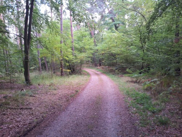
A dirt hiking path curves into a dense, green deciduous forest.
A forest trail winding through the Bellheimer Wald in Germany.

Bellheimer Wald history and protected-area timeline

The Bellheimer Wald's existence as woodland is closely tied to the post-glacial geomorphology of the Upper Rhine Plain and to patterns of historical land use rather than to a single formal designation event. While the area's ecological significance has long been recognized by naturalists, the formal European protection of the site dates to the year 2000, when it was designated under the EU Habitats Directive as FFH-Gebiet 6715-302 with the full title "Bellheimer Wald mit Queichtal."

The classification under the Habitats Directive brought new attention to the management needs of the area, including the conservation of its inland dune habitats and the protection of rare invertebrates and plants. Subsequent publications by the regional conservation society GNOR and the Pollichia natural history association describe a model project for protected-area management in the Natura 2000 site, focusing on balancing forest use, grassland conservation, and the protection of the dune biotopes.

In addition to the Habitats Directive site, the Bellheimer Wald is included in the overlapping Bird Directive zone (Vogelschutzgebiet 6715-401), which links it with the Offenbacher Wald and the Queich meadows to form a larger bird-protection landscape. Together, these designations anchor the forest within the Natura 2000 network of European protected areas.

Bellheimer Wald landscape and geographic character

The landscape of the Bellheimer Wald is defined by its position on an alluvial fan that gently slopes eastward from the Haardt foothill zone near Godramstein down toward the Rhine floodplain near Germersheim. The fan takes the form of a broad triangle, widening as the Queich's energy dissipates across the plain. Soils are predominantly sandy, with coarser gravel closer to the upland margin and finer sands farther out toward the Rhine.

Far from being a uniform sand sheet, the area features subtle topographic variation. At the outer fringe of the fan, where the finest sediments accumulated, ancient wind activity produced inland dunes, of which the Germersheimer Düne on the eastern side of the forest remains the most notable. The dune rises slightly above the surrounding flat terrain and carries an unusual combination of open sand surfaces, sand grasslands, and semi-dry grassland.

To the west and southwest, the forest meets the Haardt, the steep eastern edge of the Palatinate Forest. To the north and south, the Bellheimer Wald merges visually with neighboring alluvial-fan forests, the Speyerer Wald and the Bienwald respectively. Two state roads, the B 9 federal highway, and the Schifferstadt-Wörth railway cross the forest, breaking the woodland into accessible sections, but the overall impression remains one of a continuous lowland forest embedded in an otherwise agricultural Rhine Plain.

Bellheimer Wald ecosystems, habitats, and plant life

Ecologically, the Bellheimer Wald represents an unusual juxtaposition of habitats within a single protected landscape. The dominant habitat type is sandy lowland woodland, composed of mixed forest stands that have survived on the alluvial fan in contrast to the cleared agricultural plains around them. Among the trees, oak and pine are characteristic, reflecting the dry, acidic sandy soils.

Alongside the woodland, the most ecologically distinctive habitat is the open inland dune and dry sand grassland complex on the eastern fringe. These open areas are colonized by specialized plant communities such as silver grass grasslands (Silbergrasrasen) and semi-dry sand grasslands, which together support a contingent of warm- and dry-adapted species rare in central Europe.

The Queich stream valley running through and adjacent to the forest adds a riparian dimension. Its floodplain meadows and the streamside vegetation form part of the same protected mosaic, providing wetland edges and wet meadows that complement the dry sand and forest habitats.

Bellheimer Wald wildlife and species highlights

The wildlife values of the Bellheimer Wald are strongly shaped by the combination of dry sand habitats and forest, which together support a surprising breadth of rare species for an inland, lowland area. The Germersheimer Düne in particular has become a focus of conservation interest because of its relict and re-discovered populations.

Among the most notable bird species is the woodlark (Heidelerche), an increasingly rare songbird in central Europe that uses the dune's open habitats. Its song in early summer nights is considered one of the most striking natural sounds in western and central European landscapes.

The invertebrate fauna is equally significant. The dune's sand grasslands host fifteen recorded grasshopper species, including threatened ones such as the western sawbush cricket (Platycleis albopunctata), the green band-winged grasshopper (Aiolopus thalassinus), the blue-winged locust (Oedipoda caerulescens), and the red-legged grasshopper (Omocestus haemorrhoidalis). Notable steppe bees (Nomioides minutissimus) were rediscovered after more than 140 years of absence in Rhineland-Palatinate, and the area also supports the very rare St. John's wort jewel beetle (Agrilus hyperici), the stag beetle (Lucanus cervus), and a range of rare butterflies and damselflies.

The forest itself and the Queich valley harbor a separate suite of protected species, including Bechstein's bat (Myotis bechsteinii) and the greater mouse-eared bat (Myotis myotis), the great crested newt (Triturus cristatus), the weather loach (Misgurnus fossilis), several rare dragonflies such as the green gomphid (Ophiogomphus cecilia) and the Mercury bluet (Coenagrion mercuriale), and rare butterflies including the dusky large blue (Maculinea nausithous), the scarce large blue (Maculinea teleius), and the large copper (Lycaena dispar).

Bellheimer Wald conservation status and protection priorities

The Bellheimer Wald mit Queichtal is a formally protected area under the European Natura 2000 network, recognized in 2000 as a Habitats Directive site with the national code 6715-302. Its conservation status is classified under IUCN Category IV, indicating that it is managed primarily for the conservation of particular habitats and species rather than as a strict ecological reserve.

The principal conservation value lies in the survival of sandy lowland woodland and open inland dune habitats at the eastern edge of the forest. These dune and dry-grassland communities are highly localized within the Rhine Plain and represent a key reason why the area was included in the Natura 2000 network. The site also forms part of the broader Bird Directive zone covering the Offenbacher Wald, the Bellheimer Wald, and the Queich meadows, ensuring additional protection for the area's bird species.

Management efforts have been documented through regional conservation publications, including a model project focusing on the practical challenges of protected-area management within Natura 2000. Topics addressed include balancing forestry operations on sandy soils with the preservation of open sand habitats, protecting dry-grassland species, and coordinating conservation between the forest zone and the Queich stream corridor.

Bellheimer Wald cultural meaning and human context

The Bellheimer Wald is part of the southern Palatinate (Südpfalz) cultural landscape, situated among villages and small towns such as Bellheim, Zeiskam, Westheim, Lustadt, and Sondernheim. The forest sits at the interface between the densely settled eastern Rhine Plain and the Haardt margin of the Palatinate Forest, and in everyday regional life it has long served as a readily accessible local woodland for residents of the surrounding communities.

The place name itself comes from the village of Bellheim, which borders the forest immediately to the south and lends it a strong sense of local identity. Walking trail networks, maintained by the local tourism organization and the municipality of Bellheim, weave through the forest and reinforce its role as a nearby recreation and nature experience area linking the local population with the broader Natura 2000 landscape.

Top sights and standout views in Bellheimer Wald

The Bellheimer Wald's profile is shaped by the unusual combination of a protected inland dune, surviving sandy alluvial-fan forest, and a stream corridor in the Queich valley. The Germersheimer Düne on the eastern forest edge stands out as a small but ecologically dense area, where relict species such as the steppe bee have reappeared after long absences and where the song of the woodlark at dusk remains a memorable feature of the landscape.

Alongside this micro-habitat, the forest as a whole represents one of the defining segments of the alluvial-fan woodland chain on the left bank of the Rhine, sitting between the Speyerer Wald and the much larger Bienwald. Its protected status under the EU Habitats Directive since 2000 and its incorporation into the Bird Directive zone make it a regional anchor point for conservation in the southern Palatinate.

Best time to visit Bellheimer Wald

The Bellheimer Wald can be appreciated at any time of year, but the most evocative seasons align with the periods when its characteristic habitats are most expressive. In late spring and early summer, the open dry grasslands and sand habitats of the Germersheimer Düne become most active with insects, and the dusk song of the woodlark becomes a memorable feature of evening walks.

In late spring, the dune's rare plants and dry-grassland flora are at their peak, supporting the highest diversity of specialist insects. Summer brings warm conditions ideal for observing the dry sand flora and invertebrate fauna, while autumn offers the more typical lowland forest experience of changing leaf colors and fungi in the woodland interior. Winter walks can reveal the broad structure of the dune and the open, sandy character of the landscape beneath the forest canopy.


Monthly climate preview

Long term representative point measurements tracking monthly temperature and precipitation variation

Bellheimer Wald Climate Normals, Average Temperature and Precipitation Rhythm

Representative coordinate records show measured shifts in average monthly temperature and daily precipitation across the Bellheimer Wald protected landscape. Examining the full twelve month profile reveals detailed temperature ranges and precipitation patterns derived from long term climatology data.
Annual mean10 °C
1 °C21 °C
Jan
Feb
Mar
Apr10°
May15°
Jun19°
Jul21°
Aug20°
Sep16°
Oct10°
Nov
Dec
Warmest month
July

20.9 °C

Coolest month
January

0.6 °C

Wettest month
May

2.3 mm/day

Driest month
April

1.5 mm/day

Park location guide

Geography guide, regional context, and park location map for Bellheimer Wald

Bellheimer Wald park geography, regions, and map view in Germany

Understand where Bellheimer Wald sits in Germany through a broader geographic reading of the surrounding landscape, nearby location context, and its mapped position within the national park landscape.

How Bellheimer Wald fits into Germany

Germany is a federal republic in Western and Central Europe with a population of over 83 million across sixteen constituent states. It is Europe's largest economy by nominal GDP and a major global exporter and importer. The capital is Berlin, and the country borders Denmark, Poland, Czech Republic, Austria, Switzerland, France, Luxembourg, Belgium, and the Netherlands.

Wider geography shaping Bellheimer Wald in Germany

Germany is located in Western and Central Europe, spanning 357,022 km². It borders Denmark to the north, Poland and the Czech Republic to the east, Austria and Switzerland to the south, and France, Luxembourg, Belgium, and the Netherlands to the west. The country has coastlines on the Baltic Sea and North Sea to the north, with the Alps located in the southern region.

Map view of Bellheimer Wald

Use this park location map to pinpoint Bellheimer Wald in Germany, understand its exact geographic position, and read its mapped placement within the surrounding landscape more clearly.

Pigeon | © OpenStreetMap contributors

Location context for Bellheimer Wald

Rhineland-Palatinate

Visual reference collection for alluvial fan woodland terrain and rare inland dune habitats

Bellheimer Wald Landscapes, Scenery, and Protected Area Photos

Explore detailed photographs capturing the sandy soils, lowland forest canopy, and open grass mosaics of Bellheimer Wald. Visual documentation reveals the distinct ecological terrain of this protected Rhine Plain conservation area.

A dirt hiking path curves into a dense, green deciduous forest.

Park atlas

Compare adjacent alluvial forests and regional nature reserves across the Upper Rhine Plain

Parks Near Bellheimer Wald and Surrounding Protected Landscapes

Browsing other protected areas near Bellheimer Wald reveals connected woodland chains and sandy alluvial terrain across the southern Palatinate region. Expanding the geographic comparison provides valuable context on regional conservation networks and lowland forest habitats.
Watercolor painting of a tranquil wetland landscape with soft green vegetation and a calm water body, reflecting the floodplain environment of the Rhine river.
Nature reserveLandkreis Germersheim
About 2.5 km away#1 closest

Southeast

Hördter Rheinaue Nature Reserve: Landscape and Geographic Context in Landkreis Germersheim

Examining the hydrology and floodplain forest of the German Rhine.

Hördter Rheinaue serves as a critical node in the Palatinate Rhine floodplains, preserving a vast mosaic of willow and poplar forests alongside stable hardwood stands. Analyze the mapped terrain shaped by centuries of river activity, including the meandering Michelsbach and associated oxbow systems that define this essential protected corridor in western Germany.

Area
8.18 km²
Established
1966
IUCN
IV
Relief
Lowland
A horizontal watercolor painting depicting a soft-focus landscape with a central tree, calm water, and rolling hills in the background.
Nature reserveRhineland-Palatinate
About 7 km away#2 closest

East

Brückenkopf Nature Reserve: An Atlas of Protected Floodplain Geography in Rhineland-Palatinate

Detailed mapping of rare wetland habitats and regional floodplain zones

Brückenkopf offers a unique look at small-scale habitat conservation in the Germersheim district. This nature reserve protects a vital fragment of the Upper Rhine floodplain, serving as a sanctuary for specific wetland flora and rare invertebrates. Gain a better understanding of its location between major infrastructure corridors and the river, marking it as a significant component of regional conservation strategy.

Area
0.357 km²
Established
1982
IUCN
IV
Relief
Lowland
A pale, atmospheric watercolor painting showing a quiet river scene with green trees and a hanging branch in the foreground, rendered in a light and airy style.
Nature reserveRhineland-Palatinate
About 8.4 km away#3 closest

Northeast

Schwarzwald Nature Reserve: A Protected Rhine Floodplain Landscape in Rhineland-Palatinate

Geographic atlas of alluvial forests and oxbow river dynamics

Schwarzwald represents a significant nature reserve in Germany, characterized by its position between the modern Rhine and the Lingenfelder Altrhein. The area contains a rich collection of floodplain features, including alluvial forests, pollarded willows, and standing gravel pit lakes, offering a comprehensive look at the riparian geography of the Upper Rhine.

Area
3.41 km²
Established
1997
Soft watercolor painting of an oxbow lake landscape with green riverbanks, trees, and distant rolling hills against a pale sky.
Nature reserveRhineland-Palatinate
About 9.7 km away#4 closest

Southeast

Leimersheimer Altrhein Nature Reserve: Mapped Geography and Protected Area Context

A preserved Rhine oxbow ecosystem in Rhineland-Palatinate

Leimersheimer Altrhein represents a rare, enduring fragment of the historical Rhine floodplain. This site hosts vital waterbird populations within an enclosed water landscape, providing essential habitat connectivity in a heavily regulated river region. Gain insights into the specific terrain, boundary configurations, and riparian mosaic that define this protected nature reserve.

Area
15 km²
Established
2004
IUCN
IV
A soft, light watercolor painting of a wetland scene with a winding river branch, reeds, and low-lying greenery under a hazy sky.
Nature reserveRheinland-Pfalz
About 11 km away#5 closest

South

Neupotzer Altrhein Nature Reserve: A Detailed Map and Geographic Overview

Protected floodplain landscape in the Rheinland-Pfalz region.

The Neupotzer Altrhein reserve stands as a prominent example of Rhine floodplain recovery, featuring a diverse topography of slow-moving water channels, marshes, and softwood alluvial forests. Located in the Rheinland-Pfalz district of Germersheim, this protected area offers significant insight into the historical and natural shifts of the Rhine corridor, serving as a key refuge within the European Natura 2000 network.

Area
2.375 km²
Established
2000
IUCN
IV
Relief
Lowland
A horizontal watercolor painting showing a stylized, soft-focus forest landscape with green trees against a pale, warm-toned ground.
Protected areaRhineland-Palatinate
About 11 km away#6 closest

North

Speyerer Wald: Protected Alluvial Forest and Inland Sand Dune Landscape

Regional geography and protected area context in Rhineland-Palatinate.

Speyerer Wald offers a look into the formation of Rhine Plain alluvial fans and the survival of forest ecosystems on poor, sandy soils. This protected expanse showcases the intersection of inland dunes, dry sand grasslands, and riparian stream corridors. It serves as a key case study in regional landscape evolution, highlighting how ice age deposits continue to dictate current habitat distribution and nature conservation priorities.

Established
1981
Relief
Lowland
Climate
Temperate
Access
Easy access
Nature reserveRheinland-Pfalz
About 12 km away#7 closest

North

Lochbusch-Königswiesen Nature Reserve: Protected Wetland and River Floodplain Geography

A detailed look at regional floodplain mapping in Rheinland-Pfalz

Lochbusch-Königswiesen stands as a critical protected landscape within the Rhine lowlands of Rheinland-Pfalz. Centered on the Speyerbach river corridor, this nature reserve maintains rare lowland bog and wet meadow communities. Its structured boundaries demonstrate the persistence of floodplain geography in an intensively managed region, offering a distinct focus for those examining protected-area distribution in Germany.

Area
1.99 km²
Established
1983
Nature reserveRheinland-Pfalz
About 13 km away#8 closest

Northeast

Flotzgrün Nature Reserve: Protected Floodplain Landscapes and Rhine Geography in Rheinland-Pfalz

Mapping historical island creation and modern conservation polders

Flotzgrün serves as a compelling geographic entity within the Upper Rhine, functioning as both an active flood management polder and a protected riparian environment. This site offers insights into the intersection of 19th-century river straightening and modern ecological restoration, revealing a landscape defined by controlled wetlands, old river arms, and managed floodplain habitats.

Area
3.4 km²
Relief
Lowland
Scope
Terrestrial
Water
Major water bodies

Common questions about visiting, size, designation, and location context for Bellheimer Wald

Bellheimer Wald FAQs for park facts, access, geography, and protected area context

Find quick answers about Bellheimer Wald, including protected-area facts, park geography, trail and visitor context, and how the park fits into its surrounding country and regional landscape.
MoriAtlas Explorer

Continue Your Protected Areas Search Across the Global Atlas

Deepen your exploration by continuing the structured search for national parks and protected areas worldwide. Utilize the comprehensive filtering capabilities to compare different conservation landscapes and refine your understanding of global park geography. Discover more about the distribution and characteristics of protected natural areas.

Global natural geography