
Mori Atlas logo
Nature reserveBellinger Berg

Discover the unique geography, dry grassland mosaic, and conservation boundaries of this prominent Spessart limestone hill

Bellinger Berg Nature Reserve: Mapping the Limestone Cones and Protected Terrain of Hessen

(Naturschutzgebiet Bellinger Berg)

Bellinger Berg stands as a distinct 345-meter Muschelkalk cone in the eastern Spessart foothills of Hessen, Germany. This 95-hectare protected area serves as a refuge for rare species by concentrating dry calcareous grasslands, scrub, and woodland within its defined boundaries. As both a designated nature reserve and a recognized European FFH site, the hill represents a significant mosaic of habitats that contrast with the surrounding forest and agricultural landscapes.

limestone hillshell-limestoneMuschelkalkcalcareous grasslanddry grasslandhabitat mosaic
A flat vector illustration of a stone watchtower standing in a forest at the base of large cliffs with a waterfall in the background.

Bellinger Berg

Nature reserve

Park overview

Structured park overview, official facts, and landscape profile for Bellinger Berg

Bellinger Berg park facts, protected area profile, and essential visitor context

Review the core facts for Bellinger Berg, including designation, size, terrain, visitor scale, habitats, and operating context in one park-focused overview.

About Bellinger Berg

Bellinger Berg sits in the eastern part of the Hessian Spessart, near the town of Steinau an der Straße, and represents a classic, compact example of a southern German limestone hill protected under both national and European nature conservation frameworks. The hill itself is relatively modest. It rises to roughly 345 meters above sea level, but its shell-limestone geology sets it apart from the surrounding sandstones and supporting land.

The reserve covers about 95 hectares of grassland, scrub, and forest on the slopes and around the foot of the cone. Because the hill is delimited by roads on three sides, the protected area has unusually clear boundaries, which makes it relatively easy to delineate in policy terms and on the ground. Its Natura 2000 code, DE5622305, and its Hessian designation 1435040, mark it as both a national Naturschutzgebiet and an FFH site, since 2008 with the same name and area.

Ecologically, Bellinger Berg's main importance is its concentration of dry, calcareous habitats in a region that is otherwise heavily forested. The combination of thin Muschelkalk soils, warm microclimates, and a centuries-long pattern of grazing and coppice management has produced habitats that are now scarce across much of lowland Germany. Although the reserve is too small to host a complete ensemble of large mammals or extensive forest communities, it is locally significant for the survival of species that depend on open, warm, and base-rich conditions in the Spessart foothills.

Quick facts and research context for Bellinger Berg

Bellinger Berg is a shell-limestone hill in the eastern Spessart, located on the territory of the town of Steinau an der Straße in the Main-Kinzig district of Hesse. Around 95 hectares have been protected as a Naturschutzgebiet since 1985 and as an FFH (Flora-Fauna-Habitat) site since 2008, making it one of the many small sites that form the Natura 2000 network in this part of Germany.

The site is bordered by local and state roads, which define a clearly demarcated protected area wrapped around the hill rather than extending into the surrounding agricultural land. Its official designation code is 1435040, and it has the Natura 2000 site code DE5622305.

Protection and recognition

Documented protection history and official Natura 2000 listings

Bellinger Berg Protection Status and International Recognition Data

Bellinger Berg maintains documented terrestrial protection status established in 2008 alongside verified Natura 2000 recognition records. Structured conservation data details management scope and international framework listings for this protected area.

International recognition

Protection details

Protection scope
Terrestrial
Designated year
2008
Transboundary protection
No
WDPA ID
162368
Park context

Deeper park guide and search-rich context for Bellinger Berg

Bellinger Berg history, landscape, wildlife, and travel context

Explore Bellinger Berg through its history, landscape character, ecosystems, wildlife, conservation priorities, cultural context, and seasonal travel timing in a structured park guide built for atlas discovery and search intent.

Why Bellinger Berg stands out

Bellinger Berg is best known as a protected limestone cone that concentrates dry, warm-loving habitats within an otherwise more densely wooded part of the Spessart. The combination of Muschelkalk bedrock, south-facing slopes, and a long history of traditional land use has produced a mosaic of calcareous grassland, scrub, and woodland that shelters rare species.
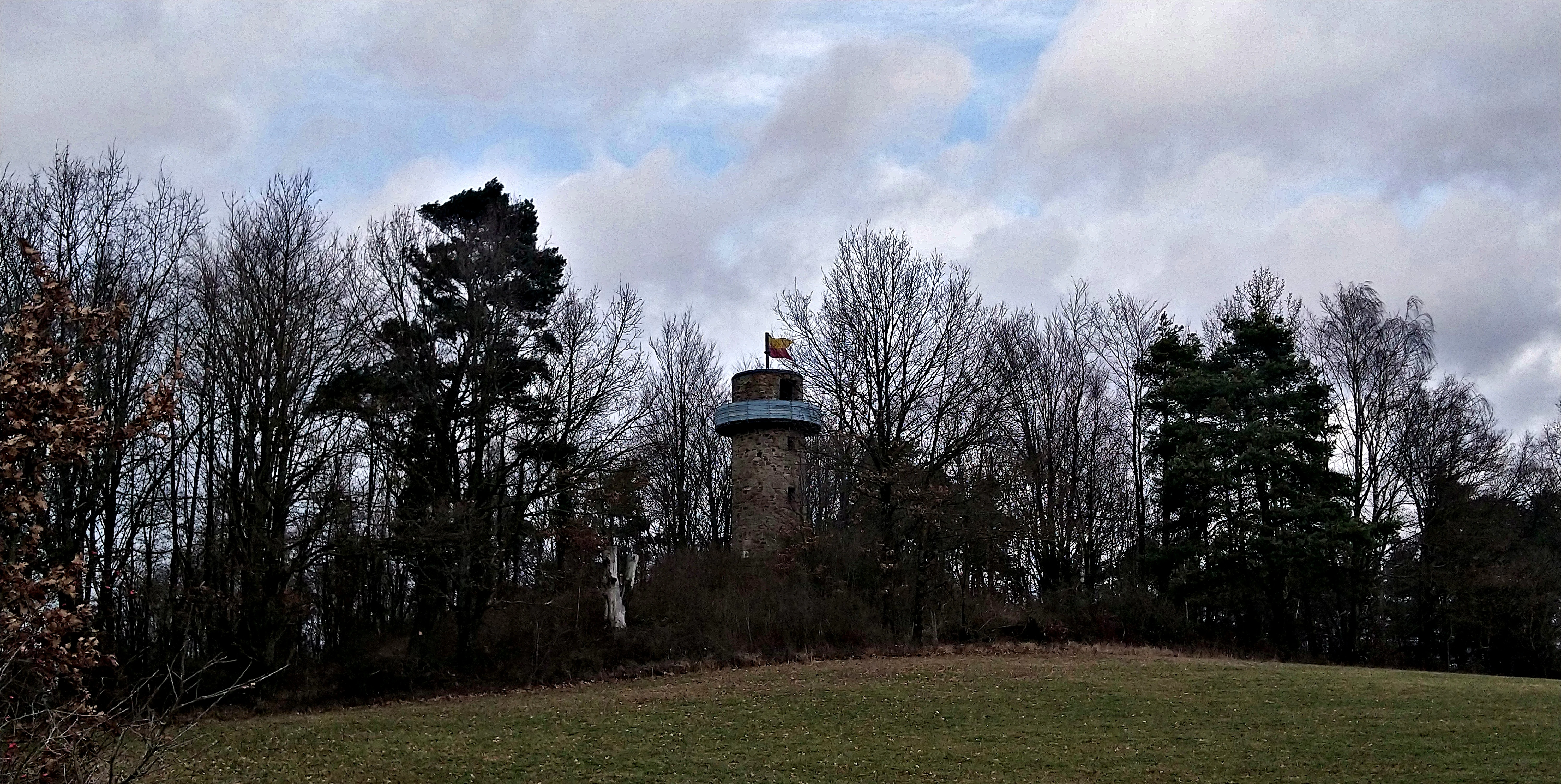
A stone observation tower known as the Bellingerwarte stands surrounded by a dense forest on a hill, viewed across a grassy field under a cloudy sky.
The Bellingerwarte tower situated atop the Bellinger Berg.

Bellinger Berg history and protected-area timeline

The area that today forms Bellinger Berg was protected as a Hessian nature reserve on 16 December 1985, under the designation 1435040. The legal ordinance establishing the reserve was published in the Staatsanzeiger für das Land Hessen, anchoring the site's status in German nature conservation law and giving the small hill one of the standard regional protections available in Hesse at that time.

In 2008 the site was additionally designated as a Flora-Fauna-Habitat (FFH) area, the German implementation of the European Union's Habitats Directive (92/43/EWG). The FFH designation is identical in both name and area to the existing national nature reserve, reflecting the way many smaller Hessian sites were retrofitted into the European Natura 2000 network as that network expanded in the late 2000s.

The reserve's purpose, as stated in the establishing ordinance, is to protect and maintain this distinctive Muschelkalk cone as a habitat for several rare and threatened animal and plant species. The wording makes clear that protection is driven not by any single species but by the unusual concentration of rare life that the hill's geology and microclimate support.

Bellinger Berg landscape and geographic character

Bellinger Berg's landscape is dominated by a single, strongly shaped limestone cone that rises above the surrounding lowlands of the eastern Spessart. At roughly 345 meters, it is not a high summit, but its conical form and bare-looking slopes give it a distinctive silhouette in the local skyline, especially when viewed from the south and west.

The bedrock is Muschelkalk, a Triassic-age shell-limestone that produces thin, base-rich soils. On the slopes this translates into dry, sun-exposed terrain that contrasts sharply with the deeper, moister soils of the broader Spessart. Steeper sections are interspersed with flatter shoulders and small benches where soil has accumulated, giving the hill a varied micro-topography.

The surrounding land is agricultural and small-village in character, with Bellings to the south-east and road corridors wrapping around three sides of the hill. These roads effectively frame the protected zone and separate it visually from the wider cultivated landscape.

Bellinger Berg ecosystems, habitats, and plant life

The nature of Bellinger Berg revolves around the ecological patterns that the Muschelkalk bedrock and the dry, warm microclimate create. Because the limestone weathers into shallow, nutrient-rich soils and the slopes face directly into the sun, the hill supports open and semi-open vegetation rather than closed forest, which is the dominant cover in much of the surrounding Spessart.

The protected zone is a mosaic. Dry calcareous grasslands and related Magerrasen occupy the warmer, sunnier slopes, while scrub and low woodland colonise marginal areas and less intensively grazed patches. Toward the foot of the hill and on the more shaded flanks, mixed deciduous woodland, again typical of the eastern Spessart, takes over, creating a gradient from open rock- and grass-influenced vegetation to denser forest.

This habitat concentration, rather than any single species or community, is what gives the site its conservation weight. Such dry, calcareous, sun-facing ecosystems are now rare in central Germany because traditional grazing and other rural land uses that maintain them have largely disappeared. By safeguarding what is effectively a small island of dry limestone habitat, Bellinger Berg contributes to the broader Mannerwald and Hessian network of small reserves that maintain ecological diversity across agricultural landscapes.

Bellinger Berg wildlife and species highlights

Bellinger Berg is a refuge for the kind of wildlife that depends on dry, warm, base-rich habitats that are scarce elsewhere in the region. The reserve's establishment ordinance specifically refers to multiple rare and threatened animal species, indicating that the site has clear value for fauna beyond a casual mention, even though individual species are not named in the public summary documentation.

Typical inhabitants of such limestone grasslands in Hesse include invertebrates adapted to dry, flower-rich turf, such as certain butterflies, wild bees, and grasshoppers, as well as a range of reptiles and ground-nesting birds that use the open slopes. The mosaic of scrub and woodland that frames these grasslands adds breeding and shelter habitat for woodland and edge species at a fine scale.

The site's value for wildlife lies more in the persistence and connectivity of habitat over time than in the fame of any single species. Because the reserve has been protected in roughly its current extent since 1985, populations of habitat-specialist species have had decades of relatively stable conditions to maintain themselves, which is increasingly important in landscapes that are intensively used.

Bellinger Berg conservation status and protection priorities

From a conservation perspective, Bellinger Berg is significant as one of the many smaller reserves in Hesse that link national protection with the European Natura 2000 framework. Its dual status as a Naturschutzgebiet under Hessian law and as an FFH site since 2008 places it within the same EU-level reporting and monitoring system that governs larger, more famous sites, ensuring that its condition is tracked alongside habitat and species assessments.

The reserve's deeper conservation meaning comes from the role of small, isolated patches of dry limestone habitat in regional biodiversity. In central Germany, the historical patterns of grazing, coppicing, and marginal land use that produced rich calcareous grasslands have largely disappeared, and surviving fragments are scattered, small, and vulnerable. Bellinger Berg represents one such fragment, and its protection helps to keep a viable local population of habitat-specialist species alive.

The site's relatively clear boundaries, defined by roads, also make it a practical study and management case. Because the protected area is delimited in space and tracked through both national IDs and Natura 2000 codes (1435040 and DE5622305), its management effectiveness can be monitored and compared to that of neighbouring reserves in the Main-Kinzig district.

Bellinger Berg cultural meaning and human context

The cultural setting of Bellinger Berg is the eastern fringe of the Hessian Spessart, an area historically shaped by small-scale agriculture, grazing, and forestry on the margins of larger forested uplands. The presence of a medieval-era lookout point, the Bellingerwarte, on the hill is the most visible cultural marker and gives the site its locally distinctive toponym "Bellinger."

The surrounding landscape carries the imprint of centuries of rural land use, with the village of Bellings and the broader town of Steinau an der Straße providing the human context. The traditional ways of using the hill, including grazing livestock on dry slopes, are likely part of the reason that the open habitats still survive; those patterns of use have largely disappeared elsewhere, which is a relevant cultural backdrop to the reserve's ecological story.

Top sights and standout views in Bellinger Berg

Bellinger Berg's main distinguishing feature is the unusual compression of habitat types onto a single small hill. A 345-meter Muschelkalk cone in an otherwise forested part of the Spessart, it concentrates dry calcareous grassland, scrub, and woodland within a roughly 95-hectare envelope that has been protected since 1985.

Its dual role as both a national nature reserve and a European FFH site, with shared boundaries and an identical area, makes it a small but clean example of how Natura 2000 sites are built on top of existing German protection regimes. The presence of the historical Bellingerwarte lookout tower on the hilltop adds a recognizable cultural landmark that gives the site its name.

Best time to visit Bellinger Berg

The most natural times to visit Bellinger Berg are spring and early summer, when the dry calcareous slopes come into flower and the contrast between open grassland and surrounding woodland is at its clearest. Late spring into early summer also tends to bring the warmest, most settled conditions on south-facing slopes in this part of Hesse.

Autumn is a quieter alternative, with cooler weather and softer light that emphasises the shape of the limestone cone and the Bellingerwarte on its summit. Winter visits are possible but the dry habitats are less visually distinctive, and the value of a visit comes more from the broader Spessart setting than from the grassland communities that define the site in warmer months.

Monthly climate preview

Long-term monthly temperature and precipitation averages for Hessen

Bellinger Berg Climate Normals and Annual Temperature Rhythm

Bellinger Berg records long-term monthly temperature variations alongside steady precipitation patterns based on representative coordinate sampling. Reviewing the comprehensive twelve-month climate profile reveals complete statistical details for this protected terrain.
Annual mean8 °C
-1 °C18 °C
Jan-1°
Feb
Mar
Apr
May12°
Jun16°
Jul18°
Aug18°
Sep14°
Oct
Nov
Dec
Warmest month
July

18.1 °C

Coolest month
January

-1.2 °C

Wettest month
July

2.6 mm/day

Driest month
April

1.6 mm/day

Park location guide

Geography guide, regional context, and park location map for Bellinger Berg

Bellinger Berg park geography, regions, and map view in Germany

Understand where Bellinger Berg sits in Germany through a broader geographic reading of the surrounding landscape, nearby location context, and its mapped position within the national park landscape.

How Bellinger Berg fits into Germany

Germany is a federal republic in Western and Central Europe with a population of over 83 million across sixteen constituent states. It is Europe's largest economy by nominal GDP and a major global exporter and importer. The capital is Berlin, and the country borders Denmark, Poland, Czech Republic, Austria, Switzerland, France, Luxembourg, Belgium, and the Netherlands.

Wider geography shaping Bellinger Berg in Germany

Germany is located in Western and Central Europe, spanning 357,022 km². It borders Denmark to the north, Poland and the Czech Republic to the east, Austria and Switzerland to the south, and France, Luxembourg, Belgium, and the Netherlands to the west. The country has coastlines on the Baltic Sea and North Sea to the north, with the Alps located in the southern region.

Map view of Bellinger Berg

Use this park location map to pinpoint Bellinger Berg in Germany, understand its exact geographic position, and read its mapped placement within the surrounding landscape more clearly.

Pigeon | © OpenStreetMap contributors

Location context for Bellinger Berg

Hessen
Recorded earthquake history

Review Recorded Seismic Activity and Earthquake History Near Bellinger Berg

Explore the structured catalogue of recorded seismic events associated with the geography of Bellinger Berg. Use this data to better understand the historical frequency and magnitude of earthquakes documented in the vicinity of this protected nature reserve in Hesse.

Bellinger Berg Earthquake History

Catalogued events

7 events

Strongest magnitude

Magnitude 5.3

Most recent event

Jul 2, 2001

This history includes earthquakes recorded inside the park or within 50 km of its borders

Visualizing the limestone hill topography, dry grasslands, and habitat mosaic of the Spessart foothills.

Bellinger Berg Photos and Protected Landscape Scenery

Browse detailed field photography capturing the distinct limestone cone, sun-exposed slopes, and rare plant habitats of Bellinger Berg. Visual records reveal the unique terrain, vegetation patterns, and conservation character defining this protected natural reserve.

A stone observation tower known as the Bellingerwarte stands surrounded by a dense forest on a hill, viewed across a grassy field under a cloudy sky.

Park atlas

Compare regional limestone hills and connected conservation landscapes across Hesse

Exploring Other Protected Areas and Nature Reserves Near Bellinger Berg

Browsing parks near Bellinger Berg reveals a broader network of protected limestone formations and specialized habitats throughout the eastern Spessart foothills. Continuing the geographic comparison exposes how isolated nature reserves maintain ecological diversity across central German landscapes.
Nature reserveHessen
1.9 km away#1 closest

North

Ohlsteinbruch bei Steinau an der Straße: Geographic Profile of the Hessen Nature Reserve

Mapped protected landscape featuring basalt outcrops and juniper heaths.

Ohlsteinbruch bei Steinau an der Straße provides a study in ecological resilience, showcasing how an abandoned basalt quarry has transformed into a high-diversity sanctuary for rare flora and invertebrates. The protected area features a unique mix of silicate rock communities, mat-grass swards, and dry meadows that reflect the complex geology of the Main-Kinzig district. This site serves as a vital Natura 2000 element, preserving essential habitats and cultural landscapes across its 25-hectare footprint.

Area
0.254 km²
Established
1984
IUCN
IV
Relief
Upland
Nature reserveLandkreis Main-Spessart
12 km away#2 closest

Southeast

Sinngrund Nature Reserve: Geographic Map and Protected Landscape Overview

Riverine corridor and wet meadow habitats in Landkreis Main-Spessart

Sinngrund preserves a unique floodplain landscape along the Sinn river in Bavaria. The area features a complex mosaic of wet meadows, oxbow channels, and forest fragments that support significant botanical populations and regional wildlife. This record details the protected boundaries and landscape context of the reserve within the broader Naturpark Spessart.

Area
3.79 km²
Established
1999
Relief
Upland
Climate
Temperate
A watercolor painting of a green, rolling meadow landscape with distant hills under a soft, light sky.
Nature reserveWetteraukreis
About 34 km away#3 closest

West

Nidderauen von Stockheim Nature Reserve: A Detailed Geographic and Protected Landscape Map

Wetland floodplain geography in the Wetteraukreis region

This protected nature reserve spans 51 hectares of the Nidder river valley, forming a critical segment of the Auenverbund Wetterau. The landscape is defined by its mosaic of wet meadows, ponds, and tall herb vegetation, maintained by targeted conservation management and river restoration. Access the map-driven context of this European FFH site to understand its role in regional wetland preservation and habitat connectivity.

Area
0.512 km²
Established
1981
Relief
Lowland
Climate
Temperate
Nature reserveHessen
34 km away#4 closest

Southwest

Kinzigaue von Langenselbold: Nature Reserve and Protected Floodplain in Hessen

Riparian ecosystems, alluvial forests, and wetland geography

Spanning 129 hectares, Kinzigaue von Langenselbold represents a well-preserved riverine corridor in central Germany. The reserve integrates the meandering Kinzig river, mature gallery forests, and the Ruhlsee into a compact, protected landscape that serves as an essential habitat for diverse bird species and rare floodplain vegetation.

Area
1.287 km²
Established
1980
IUCN
IV
Protected areaGermany
About 36 km away#5 closest

West

Bruch von Heegheim Protected Area: A Wetland Landscape in the Nidder River Valley

Mapped wetland habitats and ecological site geography

Bruch von Heegheim is a specialized nature reserve that protects a delicate mosaic of shallow water bodies and reed-dominated marshes in the German district of Wetteraukreis. The site serves as a vital refuge for European tree frogs and breeding marshland birds, demonstrating how compact protected lands contribute to broader biodiversity conservation within agricultural floodplains.

Area
0.108 km²
Established
1976
Relief
Lowland
Climate
Temperate
Nature reserveHesse
About 36 km away#6 closest

West

Im Rußland und in der Kuhweide bei Lindheim: Nature Reserve and Floodplain Geography

Protected grassland landscapes in the Wetterau, Hesse.

Located in the Wetteraukreis district of Hesse, this nature reserve protects extensive floodplain meadows along the Nidder river. The area is defined by its open grassland mosaic, providing critical refuge for meadowbirds and diverse amphibian populations. Access detailed map data and landscape context for this significant German conservation site.

Area
2.495 km²
Established
1984
Relief
Lowland
Climate
Temperate
Protected landscapeHesse
About 36 km away#7 closest

Northeast

Naturpark Hessische Rhön: Geographic Profile and Protected Landscape Mapping

Mapping the Rhön low mountains and upland ecosystems in Hesse

Naturpark Hessische Rhön encompasses approximately 720 square kilometers of varied terrain north and west of Fulda. The area features a distinct mosaic of forests, streams, and protected biotope complexes. This overview provides insight into the regional geography and the conservation structure defining this prominent upland protected landscape.

Area
720 km²
Established
1962
Relief
Upland
Scope
Terrestrial
A horizontal watercolor painting depicting a landscape with grassy mounds, light-colored quarry rock faces, and clusters of evergreen trees against a soft, light background.
Nature reserveHessen
About 38 km away#8 closest

Southwest

Niederrodenbacher Steinbrüche: Protected Nature Reserve and Limestone Landscape in Hessen

A managed mosaic of dry meadows and former Zechstein quarries

The Niederrodenbacher Steinbrüche nature reserve in Hessen, Germany, offers a study in post-industrial geography. Featuring a mix of steep Zechstein dolomite rock faces and the Bindernagelswiese meadow, this protected area serves as an important ecological island. Understanding its unique topography reveals how deliberate management preserves rare insect habitats and diverse calcareous flora within a broader wooded regional landscape.

Area
0.372 km²
Established
1979

Common questions about visiting, size, designation, and location context for Bellinger Berg

Bellinger Berg FAQs for park facts, access, geography, and protected area context

Find quick answers about Bellinger Berg, including protected-area facts, park geography, trail and visitor context, and how the park fits into its surrounding country and regional landscape.
MoriAtlas Explorer

Continue Your Protected Areas Search Across the Global Atlas

Deepen your exploration by continuing the structured search for national parks and protected areas worldwide. Utilize the comprehensive filtering capabilities to compare different conservation landscapes and refine your understanding of global park geography. Discover more about the distribution and characteristics of protected natural areas.

Global natural geography