
Mori Atlas logo
Nature reserveBiedenbacher Teiche bei Florshain

A dense mosaic of ponds, meadows, and floodplain woodland in the northern Hesse region

Biedenbacher Teiche bei Florshain Nature Reserve Protected Landscape and Wetland Geography

Biedenbacher Teiche bei Florshain serves as a significant nature reserve within the Schwalm-Eder district of northern Hesse, Germany. This protected landscape encompasses a compact network of water, large sedge stands, and wet meadows centered on the Biedenbach stream. The site functions as a vital refuge for threatened bird species, rare plants, and amphibian populations within the broader agricultural framework of the Schwalm river basin.

nature reservewetlandpondsfloodplain woodlandsedge bedswet meadows
A stylized vector illustration of a valley between rocky mountains with a waterfall feeding into a river, framed by pine trees in the foreground.

Biedenbacher Teiche bei Florshain

Nature reserve

Park overview

Structured park overview, official facts, and landscape profile for Biedenbacher Teiche bei Florshain

Biedenbacher Teiche bei Florshain park facts, protected area profile, and essential visitor context

Review the core facts for Biedenbacher Teiche bei Florshain, including designation, size, terrain, visitor scale, habitats, and operating context in one park-focused overview.

About Biedenbacher Teiche bei Florshain

Biedenbacher Teiche bei Florshain is a compact but ecologically significant nature reserve in the northern Hessian district of Schwalm-Eder. Although it spans only about 3.5 hectares, it ranks among the more important small wetland reserves in the region because of the diversity of habitats it conserves within a very limited footprint.

The reserve sits on the lower reach of the Biedenbach stream, right where this small watercourse meets the Silberbach, itself a tributary of the Wiera, which in turn feeds into the Schwalm. This stream-side location gives the area a natural setting defined by gently sloping floodplain land, soft alluvial soils, and a series of still-water ponds that interrupt the otherwise narrow valley corridor.

Three ponds form the core of the protected landscape, ringed by floodplain woodland and interspersed with large sedge beds, wet meadows, and stretches of the Biedenbach itself. The vertical structure of vegetation around the ponds, with overhanging trees, fringing sedges, open water, and meadow margins, creates the kind of habitat mosaic that is increasingly difficult to find in modern Central European farmland. The reserve's two separated parcels together form a coherent ecological unit focused on preserving these layered wetland habitats.

The site has long been valued by regional naturalists for its combination of botanical and ornithological interest. By formal designation as a nature reserve in 1983, the Hessian authorities ensured that the ponds and their surrounding vegetation could continue to act as a breeding and feeding area for vulnerable bird species, a home for rare plant communities, and a stronghold for threatened amphibians that depend precisely on the kind of quiet, fish-rich or fish-poor pond landscapes that broader land use changes tend to eliminate.

Quick facts and research context for Biedenbacher Teiche bei Florshain

Biedenbacher Teiche bei Florshain is a designated nature reserve in the Schwalm-Eder-Kreis of northern Hesse, Germany. The protected area consists of two parcels totaling roughly 3.5 hectares, situated on the lower reach of the Biedenbach stream near its confluence with the Silberbach, itself a tributary of the Wiera.

The reserve was placed under formal protection in 1983 under the designation 1634009. Its purpose, as defined by the protecting ordinance, is to safeguard open water surfaces, large sedge communities, and wet meadows that together support threatened breeding birds, rare plant associations, and endangered amphibians in a compact lowland stream setting.

Protection and recognition

Review documented terrestrial protection scope and official administrative records.

Biedenbacher Teiche bei Florshain Protection Status and Designated Area Facts

Biedenbacher Teiche bei Florshain maintains a documented terrestrial protection scope within global conservation databases. Official records outline the formal designation framework and administrative management parameters associated with this protected area.

Protection details

Protection scope
Terrestrial
Transboundary protection
No
WDPA ID
81398
Park context

Deeper park guide and search-rich context for Biedenbacher Teiche bei Florshain

Biedenbacher Teiche bei Florshain history, landscape, wildlife, and travel context

Explore Biedenbacher Teiche bei Florshain through its history, landscape character, ecosystems, wildlife, conservation priorities, cultural context, and seasonal travel timing in a structured park guide built for atlas discovery and search intent.

Why Biedenbacher Teiche bei Florshain stands out

This nature reserve is best known for its exceptionally dense concentration of wetland habitats packed into a very small area. The three ponds and adjacent lower Biedenbach floodplain combine to support rare large sedge stands, botanically valuable wet meadows, and an unusually rich amphibian and breeding bird community for such a modest reserve. It is also recognized for its ecological role as a refuge in the wider Schwalm-Eder agricultural landscape, where intact pond-wetland-meadow complexes have become increasingly rare. Visitors and naturalists value the site for the contrast it offers between small-scale protected wetland and the surrounding intensively used countryside.
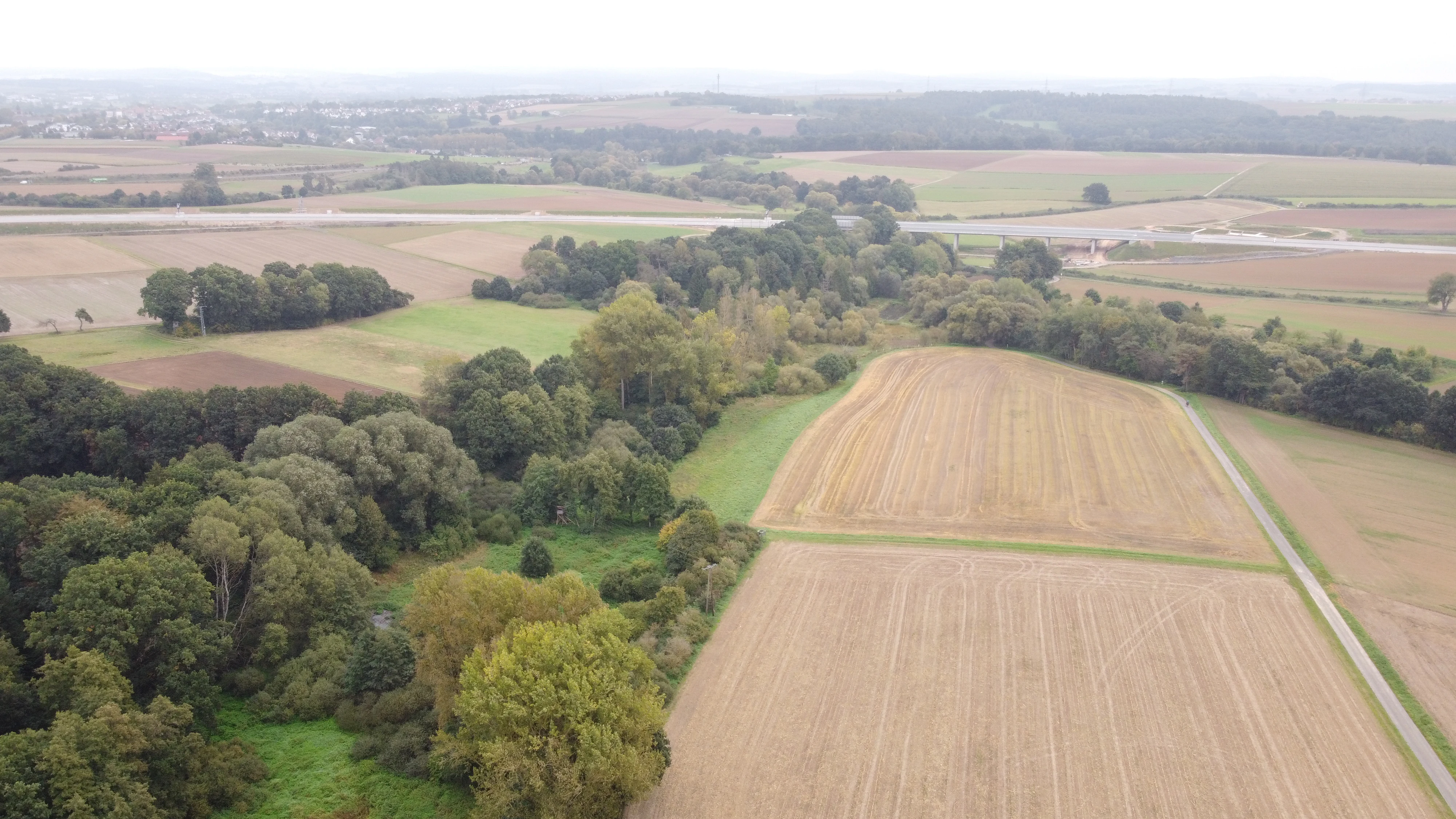
An aerial view showing a mix of green wooded patches, grassy meadows, and cultivated agricultural fields with a road visible in the distance.
Aerial view of the Biedenbacher Teiche nature reserve, showing the mosaic of meadows and woodlands.

Biedenbacher Teiche bei Florshain landscape and geographic character

The landscape of the Biedenbacher Teiche bei Florshain is shaped by the modest valley of the Biedenbach, a small lowland stream flowing through a gently carved agricultural corridor in northern Hesse. Near its mouth, where the Biedenbach meets the Silberbach on its way toward the Wiera, the valley floor flattens enough to allow a sequence of pond basins to form, giving the protected area its characteristic still-water surface.

The terrain is low-lying, flat to gently undulating, and dominated by the textures of wet meadow, dense sedge growth, and the periodic reflections of pond water. The floodplain woodland that surrounds the ponds adds a tall, soft framework to the site, so the overall impression is one of a quiet, almost hidden wetland pocket enclosed by trees and meadow.

Biedenbacher Teiche bei Florshain ecosystems, habitats, and plant life

The Biedenbacher Teiche bei Florshain represents a classic mosaic of small-scale Central European lowland wetland habitats. Open water of the three ponds is interleaved with extensive stands of large sedges, wet grasslands, and patches of alluvial woodland along the Biedenbach and Silberbach corridors.

The vegetation layering, from submerged and floating aquatic plants through emergent reeds and tall sedges, up to the fringing trees and shrubs of the floodplain forest, gives the reserve a strong ecological signature. These uncommon but characteristic plant communities are explicitly named in the protection ordinance as a reason the site was set aside, reflecting both their regional rarity and their role in supporting the broader wetland food web.

Biedenbacher Teiche bei Florshain wildlife and species highlights

The reserve is notable primarily for its bird and amphibian communities. The combination of pond surfaces, large sedge beds, and wet meadows provides breeding cover and feeding grounds for several species of conservation concern, including waterbirds and songbirds typical of lowland wetland habitat.

The ponds and their fringing wet vegetation also offer breeding habitat for a range of amphibian species, which depend on standing water with intact marginal vegetation for their early life stages. The protected status of the site, with explicit provisions against disturbance, is intended to keep these breeding and foraging functions intact across the seasons.

Biedenbacher Teiche bei Florshain conservation status and protection priorities

The ecological value of Biedenbacher Teiche bei Florshain lies in its function as a small but high-quality refuge for wetland-dependent species in a heavily used agricultural region. The 1983 protection ordinance explicitly identifies three core conservation targets: safeguarding the botanically and ornithologically valuable open water, preserving the large sedge stands and wet meadows as breeding and feeding habitat for threatened birds, and protecting rare plant communities and endangered amphibians.

By keeping disturbance low and maintaining the hydrological character of the ponds and stream sections, the reserve helps maintain ecological connectivity along the Biedenbach-Silberbach-Wiera corridor. Although the area is small compared with regional wilderness sites, its tightly defined protection makes it disproportionately important for the long-term survival of species that require quiet, structured wetland habitat in northern Hesse.

Top sights and standout views in Biedenbacher Teiche bei Florshain

The standout qualities of the Biedenbacher Teiche bei Florshain are its dense concentration of wetland microhabitats, the formal protection it has enjoyed since 1983, and its role as both a refuge and breeding ground for regionally threatened birds, plants, and amphibians. The combination of three ponds, surrounding Auwald floodplain woodland, and adjoining wet meadows makes the site a small but unusually complete example of a lowland stream-pond wetland system.

Best time to visit Biedenbacher Teiche bei Florshain

Spring and early summer are typically the most rewarding seasons for visiting a wetland reserve such as this one, when amphibian activity peaks around the ponds and the surrounding wet meadows and sedge beds are at their lushest. Birds are also most active during the breeding season, and the mix of open water, sedge, and flowering wet meadow gives the reserve its richest visual and ecological character at this time of year.


Monthly climate preview

Measured long-term temperature swings and monthly precipitation patterns across representative coordinates in Hesse

Biedenbacher Teiche bei Florshain Climate Normals and Annual Weather Rhythm

Representative coordinate records for Biedenbacher Teiche bei Florshain track sustained seasonal temperature ranges and consistent monthly precipitation levels from NASA climatology data. Examining the complete twelve-month meteorological profile reveals detailed variations in average temperature and precipitation norms across the protected landscape.
Annual mean9 °C
-1 °C19 °C
Jan-1°
Feb
Mar
Apr
May12°
Jun16°
Jul19°
Aug18°
Sep14°
Oct
Nov
Dec
Warmest month
July

18.6 °C

Coolest month
January

-0.8 °C

Wettest month
July

2.5 mm/day

Driest month
April

1.4 mm/day

Park location guide

Geography guide, regional context, and park location map for Biedenbacher Teiche bei Florshain

Biedenbacher Teiche bei Florshain park geography, regions, and map view in Germany

Understand where Biedenbacher Teiche bei Florshain sits in Germany through a broader geographic reading of the surrounding landscape, nearby location context, and its mapped position within the national park landscape.

How Biedenbacher Teiche bei Florshain fits into Germany

Germany is a federal republic in Western and Central Europe with a population of over 83 million across sixteen constituent states. It is Europe's largest economy by nominal GDP and a major global exporter and importer. The capital is Berlin, and the country borders Denmark, Poland, Czech Republic, Austria, Switzerland, France, Luxembourg, Belgium, and the Netherlands.

Wider geography shaping Biedenbacher Teiche bei Florshain in Germany

Germany is located in Western and Central Europe, spanning 357,022 km². It borders Denmark to the north, Poland and the Czech Republic to the east, Austria and Switzerland to the south, and France, Luxembourg, Belgium, and the Netherlands to the west. The country has coastlines on the Baltic Sea and North Sea to the north, with the Alps located in the southern region.

Map view of Biedenbacher Teiche bei Florshain

Use this park location map to pinpoint Biedenbacher Teiche bei Florshain in Germany, understand its exact geographic position, and read its mapped placement within the surrounding landscape more clearly.

Pigeon | © OpenStreetMap contributors

Location context for Biedenbacher Teiche bei Florshain

Hesse

Visualizing the wetland habitats, ponds, and floodplain terrain of northern Hesse

Biedenbacher Teiche bei Florshain Photos and Landscape Scenery

Visual records capture the intimate wetland mosaic, pond waters, and sedge meadows defining the Biedenbacher Teiche bei Florshain reserve. Examining field photography reveals the ecological density and tranquil protected terrain hidden within the agricultural Schwalm river basin.

An aerial view showing a mix of green wooded patches, grassy meadows, and cultivated agricultural fields with a road visible in the distance.

Park atlas

Compare adjacent wetland reserves, lowland river valleys, and northern Hesse nature habitats

Explore Parks Near Biedenbacher Teiche bei Florshain and Surrounding Protected Landscapes

Browse other protected areas near Biedenbacher Teiche bei Florshain to examine related wetland ecosystems and lowland stream habitats across northern Hesse. Comparing regional reserves reveals broader conservation patterns within the surrounding Schwalm river basin agricultural corridor.
A soft watercolor painting showing layered, gentle green hills and rolling terrain against a light, pale sky.
Nature reserveHessen
About 7.4 km away#1 closest

West

Kalkkuppen bei Winterscheid: Protected Geological Landscapes in the Gilserberg Heights

A detailed atlas view of this Hessen nature reserve

This nature reserve in the Schwalm-Eder-Kreis district protects four distinctive limestone hills built from Lower Muschelkalk. These outcrops stand as a geological anomaly within a region otherwise dominated by sandstone. The site serves as a vital component of the European Habitats Directive, offering a rare opportunity to study calcareous vegetation patterns and structural geology within the rolling terrain of northern Hesse.

Area
0.429 km²
Established
1986
IUCN
IV
A watercolor painting showing a tranquil lake shore with soft green vegetation and distant muted hills.
Nature reserveSchwalm-Eder-Kreis
About 16 km away#2 closest

Northeast

Borkener See Nature Reserve: Geographic Overview of a Reclaimed Wetland and Bird Sanctuary

A protected landscape featuring oligotrophic lake waters in Schwalm-Eder-Kreis.

Borkener See serves as a focal point for understanding the reclamation of mining landscapes in northern Germany. As an officially protected nature reserve, it provides a stable habitat for migratory bird species, with deep water basins and carefully managed wetland buffers defining its physical and ecological presence in the Westhessische Senke.

Area
3.5 km²
Established
1990
Relief
Lowland
Climate
Temperate
Nature reserveHesse
About 17 km away#3 closest

Southeast

Immichenhainer Teiche Nature Reserve: Protected Wetland and Geographic Map in Hesse, Germany

Mapped wetland refugium in the eastern Hessian uplands

Immichenhainer Teiche is a specialized nature reserve in Hesse, Germany, characterized by a series of ponds that support essential wetland habitats. Positioned within the Osthessisches Bergland, the site provides a compact, protected landscape that contrasts with the surrounding agricultural terrain. This location is recognized both as a formal nature reserve and as a European Natura 2000 FFH site, highlighting its significance for regional freshwater conservation and habitat management.

Area
0.232 km²
Established
1985
IUCN
IV
Watercolor illustration of a dirt path leading through green fields towards a distant line of trees and rolling hills against a white background.
Nature reserveHesse
About 18 km away#4 closest

East

Buchenbachtal bei Christerode Nature Reserve: Protected Landscape and Regional Geography

Mapped stream corridors and wet meadow ecosystems in Hesse

Located in central-western Germany, Buchenbachtal bei Christerode focuses on the conservation of small low-mountain streams and broadleaf forest transition zones. This nature reserve provides a essential look at riparian habitat management and the traditional agricultural integration that shapes the natural terrain of the northern Hessian region.

Area
120.5 km²
Established
1995
Water
Major water bodies
A watercolor painting depicting a soft-focus landscape with rolling green hills in the distance, a grassy foreground, and a single bare-branched tree on the right side.
Nature reserveHessen
About 20 km away#5 closest

West

Merzhäuser Teiche Nature Reserve: Geographic Atlas and Protected Landscape Overview

A dense wetland mosaic in the Burgwald region of Hessen.

Merzhäuser Teiche is a compact nature reserve situated on the edge of the Burgwald, Hesse's largest contiguous forest. Centered on three small ponds linked by the Kimmelbach, the area protects a transition zone of alder swamp, wet meadows, and nutrient-poor grassland. This site serves as a crucial habitat for waterbirds, amphibians, and rare butterflies within a characteristic central German landscape.

Area
0.201 km²
Established
1990
IUCN
IV
Relief
Lowland
A watercolor painting showing a wide, panoramic view of soft, rolling hills with patches of forest, rendered in muted pastel colors.
Protected landscapeHesse
About 20 km away#6 closest

East

Naturpark Knüll: Geography, Basalt Formations, and Protected Areas of Northern Hesse

An expansive cultural landscape defined by volcanic ridges and riverine habitats

Naturpark Knüll offers a deep look into the geological and structural diversity of the Knüllgebirge. By mapping the transitions between bunter sandstone, basalt hilltops, and fertile floodplains, this resource highlights the region's role in biodiversity conservation and sustainable land management across the Schwalm-Eder and Hersfeld-Rotenburg districts.

Area
832.58 km²
Established
2021
Relief
Mountain
Climate
Temperate
Nature reserveHessen
About 21 km away#7 closest

Southwest

Saurasen bei Schweinsberg Nature Reserve: Protected Geography and Floodplain Landscape

Ohm River basin protected area in central Hessen

Saurasen bei Schweinsberg is a compact, habitat-rich nature reserve located in the Ohm River lowland. The protected area features a unique hydrological mosaic of alder-ash woodland, sedge fens, and wet grasslands, serving as a sanctuary for diverse migratory birds and the threatened European tree frog. This site offers deep insights into the intersection of active river dynamics and traditional cultural landscapes in central Hessen.

Area
0.136 km²
Established
1985
Relief
Lowland
Climate
Temperate
Watercolor painting of green rolling hills and a calm, pale water surface under a soft, light-colored sky.
Protected landscapeHessen
About 22 km away#8 closest

North

Naturpark Kellerwald-Edersee: Protected Landscape Geography and Map Context

Mapping the forest ridges and reservoir shores of northern Hessen

Examine the geographic foundation of Naturpark Kellerwald-Edersee, a sprawling protected area in northern Hessen. The landscape is characterized by its expansive ancient beech forests, deep valleys, and the Edersee reservoir. This entry provides a detailed look at the park's low mountain terrain, elevation ranges, and the ecological connectivity between its wooded ridges and surrounding river systems.

Area
595.25 km²
Established
2001
Relief
Mountain
Climate
Temperate

Common questions about visiting, size, designation, and location context for Biedenbacher Teiche bei Florshain

Biedenbacher Teiche bei Florshain FAQs for park facts, access, geography, and protected area context

Find quick answers about Biedenbacher Teiche bei Florshain, including protected-area facts, park geography, trail and visitor context, and how the park fits into its surrounding country and regional landscape.
MoriAtlas Explorer

Continue Your Protected Areas Search Across the Global Atlas

Deepen your exploration by continuing the structured search for national parks and protected areas worldwide. Utilize the comprehensive filtering capabilities to compare different conservation landscapes and refine your understanding of global park geography. Discover more about the distribution and characteristics of protected natural areas.

Global natural geography