Mori Atlas logo
Wildlife reserveRéserve nationale de faune du Lac-Big Glace Bay

Understanding the geography, coastal terrain, and protected habitat boundaries of this Cape Breton Island refuge

Réserve nationale de faune du Lac-Big Glace Bay: A Protected Coastal Lagoon and Barrier Beach in Nova Scotia

(Big Glace Bay Lake National Wildlife Area)

Réserve nationale de faune du Lac-Big Glace Bay acts as a vital protected area on the coast of Cape Breton Island, Nova Scotia. This reserve features a distinctive brackish lagoon separated from the Atlantic Ocean by a sand and gravel barrier beach, creating a unique coastal environment for migratory bird species. By examining the mapped terrain and regenerated coastal forests, one gains insight into how this federal sanctuary manages diverse habitats on former industrial land.

national wildlife areacoastal lagoonbrackish watereelgrass bedsbarrier beachmigratory birds

Réserve nationale de faune du Lac-Big Glace Bay

Wildlife reserve

Park overview

Structured park overview, official facts, and landscape profile for Big Glace Bay Lake National Wildlife Area

Big Glace Bay Lake National Wildlife Area park facts, protected area profile, and essential visitor context

Review the core facts for Big Glace Bay Lake National Wildlife Area, including designation, size, terrain, visitor scale, habitats, and operating context in one park-focused overview.

About Big Glace Bay Lake National Wildlife Area

Big Glace Bay Lake National Wildlife Area sits along the eastern shore of Cape Breton Island, just outside the historic mining community of Glace Bay. It is part of Canada's National Wildlife Area network, a system of federal reserves managed by the Canadian Wildlife Service to protect habitat for migratory birds, species at risk, and other wildlife of national importance. At roughly 392 hectares, it is a relatively compact reserve, but its geography combines several rare coastal features in one small area.

The defining feature of the reserve is a coastal lagoon, also referred to as Big Glace Bay Lake, which is separated from the open Atlantic Ocean by a narrow barrier beach about 1.5 kilometres long, composed of sand and gravel. Because the lagoon is partially enclosed, its waters are brackish rather than fully saline, and its floor supports a healthy eelgrass meadow. This combination of sheltered, shallow, plant-rich water and an undisturbed sandy shoreline is exactly the type of habitat many waterbirds depend on during migration and breeding.

The surrounding landscape is shaped by the post-industrial character of Cape Breton's coal country. Land bordering the lagoon consists largely of former industrial wasteland that has reverted to adapted coastal forest, dominated by red spruce, red maple, white birch, and American beech. This mix of recovering woodland, brackish lagoon, eelgrass beds, and barrier beach gives the reserve a layered ecological character unusual for such a small protected area.

The reserve also overlaps geographically with the Big Glace Bay Migratory Bird Sanctuary, a related but distinct federal designation, reinforcing the site's importance for bird conservation in eastern Nova Scotia.

Quick facts and research context for Big Glace Bay Lake National Wildlife Area

Big Glace Bay Lake National Wildlife Area is a federal National Wildlife Area in Nova Scotia, Canada, established in 2022 and managed by the Canadian Wildlife Service. It lies on Cape Breton Island, southeast of the town of Glace Bay, and covers roughly 392 hectares of coastal terrain. The reserve centres on a brackish coastal lagoon protected by a sand and gravel barrier beach, and its IUCN protected-area category is IV, recognising its role as a habitat and species management area.

Protection and recognition

Review documented terrestrial protection scope and official designation records.

Protection Status and International Recognition for Réserve nationale de faune du Lac-Big Glace Bay

Terrestrial protection status and designation records for Réserve nationale de faune du Lac-Big Glace Bay appear alongside verified database entries. Structured conservation metrics outline the recorded management scope and administrative framework for this protected area.

Protection details

Protection scope
Terrestrial
Transboundary protection
No
WDPA ID
555785671
Park context

Deeper park guide and search-rich context for Big Glace Bay Lake National Wildlife Area

Big Glace Bay Lake National Wildlife Area history, landscape, wildlife, and travel context

Explore Big Glace Bay Lake National Wildlife Area through its history, landscape character, ecosystems, wildlife, conservation priorities, cultural context, and seasonal travel timing in a structured park guide built for atlas discovery and search intent.

Why Big Glace Bay Lake National Wildlife Area stands out

The reserve is best known as a refuge for waterfowl and shorebirds along the eastern Cape Breton coast, particularly the American Black Duck and the Piping Plover. It is widely recognised within Canadian conservation networks as a safe autumn migratory stopover for waterbirds and a key nesting beach for rare shorebirds.

Big Glace Bay Lake National Wildlife Area history and protected-area timeline

Big Glace Bay Lake National Wildlife Area was established in 2022 as part of Canada's federal system of National Wildlife Areas, which are administered by the Canadian Wildlife Service under Environment and Climate Change Canada. The designation came alongside growing recognition of the site's importance for migratory waterfowl and shorebirds along Cape Breton's industrialised coastline.

The lands around the lagoon were historically degraded by industrial activity linked to the coal mining heritage of the Glace Bay region. Over time, these disturbed areas transitioned into a mosaic of regenerating coastal forest, while the lagoon and its barrier beach remained relatively intact. Federal protections were eventually extended to the area to secure its habitat values against further loss.

The reserve's creation also formalised the overlap with the earlier Big Glace Bay Migratory Bird Sanctuary, consolidating federal habitat protection for the site under complementary instruments.

Big Glace Bay Lake National Wildlife Area landscape and geographic character

The landscape of Big Glace Bay Lake National Wildlife Area is defined by the contrast between open water and sheltered shoreline. The central feature is Big Glace Bay Lake, a brackish coastal lagoon set behind a 1.5 kilometre sand and gravel barrier beach. This barrier, oriented along the Atlantic shoreline, isolates the lagoon from wave action and creates the protected conditions that allow eelgrass beds to establish on the lagoon floor.

Behind the beach and around the lagoon, the terrain rises gently into coastal forest cover. These inland portions of the reserve reflect the broader industrial history of the Cape Breton coast, having transitioned from disturbed waste ground into adapted woodland. The forest composition is typical of coastal Nova Scotia, with species suited to salt-influenced soils and exposure.

The barrier beach itself is a defining and dynamic landform. Its narrow, sandy profile creates one of the most exposed environments in the reserve, which is also what makes it valuable as nesting habitat for ground-nesting shorebirds.

Big Glace Bay Lake National Wildlife Area ecosystems, habitats, and plant life

The ecological identity of the reserve rests on the interaction of three main habitats: a brackish lagoon with underwater vegetation, a sandy barrier beach, and a band of regenerating coastal forest. Together these habitats support both resident and migratory wildlife in a small but tightly integrated system.

The lagoon's brackish conditions create an environment where freshwater and saltwater species overlap, while the eelgrass beds on the lagoon floor provide an important submerged aquatic habitat. These conditions support invertebrates that, in turn, sustain waterbirds throughout the seasons.

The surrounding coastal forests on former industrial lands add a terrestrial dimension to the reserve, offering nesting, cover, and food resources for landbirds as well as buffering the lagoon from runoff and disturbance. The combined effect is a coastal habitat mosaic where marine, shoreline, and forest ecosystems meet at a small scale.

Big Glace Bay Lake National Wildlife Area wildlife and species highlights

Wildlife is the principal reason the reserve exists, and birdlife dominates its ecological profile. The site has particular significance for the American Black Duck and Canada Goose, which use the reserve as a safe autumn migratory stopover and, in the case of American Black Duck, as a wintering area; because parts of the lagoon remain ice-free in winter, around a hundred Black Ducks and Canada Geese can remain in the area, along with Common Goldeneye and Bufflehead.

The reserve's barrier beach also supports nesting populations of rare and sensitive ground-nesting birds. Among the most notable is the Piping Plover, a species of conservation concern that nests on the open sand and gravel shoreline. Common Terns and Willets also breed in the reserve, making the beach one of the most ecologically important features for breeding birds in the area.

Beyond birds, the reserve's lagoon and forest habitats support fish and invertebrate life tied to brackish waters and recovering coastal woodland, although the park's wildlife recognition remains closely tied to its waterbird and shorebird communities.

Big Glace Bay Lake National Wildlife Area conservation status and protection priorities

Big Glace Bay Lake National Wildlife Area is a formally designated federal protected area, classified as IUCN Category IV, reflecting its role as a habitat and species management area. It is administered by the Canadian Wildlife Service and its conservation mandate centres on protecting habitat for migratory birds and species of national conservation interest.

The reserve's conservation value lies in part in its capacity to deliver protection on a working Atlantic coastline that has historically been shaped by industrial land use. By securing the lagoon, its eelgrass beds, and the barrier beach, the reserve prevents further degradation of habitat that is essential to American Black Duck, Piping Plover, and other waterbirds.

Its overlap with the related Big Glace Bay Migratory Bird Sanctuary strengthens the site's protection, and the formal National Wildlife Area designation established in 2022 provides the legal and institutional basis for ongoing monitoring, habitat management, and conservation planning for the area.

Big Glace Bay Lake National Wildlife Area cultural meaning and human context

The reserve sits within the traditional territory of Mi'kmaq people of Atlantic Canada, whose long-standing presence along Cape Breton's coastline shapes the broader cultural landscape in which the protected area is situated, although specific documented cultural-heritage features within the reserve itself are not detailed in public sources.

The surrounding region is also defined by the coal mining heritage of Glace Bay and greater Cape Breton. Many of the inland lands now embraced by the reserve were historically affected by this industrial past, and the regeneration of these lands into coastal forest forms part of the broader story of environmental change and recovery along the island's eastern shore.

Top sights and standout views in Big Glace Bay Lake National Wildlife Area

A compact federal reserve where a brackish lagoon, an exposed barrier beach, and regenerated coastal forest meet, supporting autumn migration and wintering American Black Duck and Canada Goose, as well as nesting Piping Plover, Common Tern, and Willet populations in a single protected site along Cape Breton's industrial coastline.

Best time to visit Big Glace Bay Lake National Wildlife Area

Big Glace Bay Lake National Wildlife Area has a strong seasonal character shaped by birdlife and weather. Autumn is the reserve's most ecologically active period, when it functions as a major migratory stopover for waterfowl, including American Black Duck and Canada Goose, making it an especially significant season for bird-focused visitation and observation. Winter also offers distinctive viewing opportunities because parts of the lagoon remain ice-free, allowing concentrations of overwintering ducks to be observed in an otherwise frozen coastal landscape.

Monthly climate preview

Long-term representative point measurements tracking monthly temperature and precipitation variation

Réserve nationale de faune du Lac-Big Glace Bay Climate Normals and Annual Weather Rhythm

Representative coordinates record measured multi-year temperature swings and precipitation rates across twelve distinct monthly intervals for Réserve nationale de faune du Lac-Big Glace Bay. Detailed monthly climate profiles provide complete statistical breakdowns of average minimums, maximums, and daily precipitation patterns.
Annual mean7 °C
-5 °C19 °C
Jan-4°
Feb-5°
Mar-2°
Apr
May
Jun12°
Jul18°
Aug19°
Sep16°
Oct10°
Nov
Dec
Warmest month
August

19.1 °C

Coolest month
February

-4.6 °C

Wettest month
December

3.9 mm/day

Driest month
July

2.5 mm/day

Park location guide

Geography guide, regional context, and park location map for Big Glace Bay Lake National Wildlife Area

Big Glace Bay Lake National Wildlife Area park geography, regions, and map view in Canada

Understand where Big Glace Bay Lake National Wildlife Area sits in Canada through a broader geographic reading of the surrounding landscape, nearby location context, and its mapped position within the national park landscape.

How Big Glace Bay Lake National Wildlife Area fits into Canada

Canada is a federal parliamentary constitutional monarchy spanning North America from the Atlantic to the Pacific and Arctic Oceans. With a population of over 41 million, it is officially bilingual in English and French at the federal level. The country gained independence from the United Kingdom through a gradual process culminating in 1982.

Wider geography shaping Big Glace Bay Lake National Wildlife Area in Canada

Canada occupies the northern portion of North America, sharing its longest international border with the United States. The country extends from the Atlantic Ocean to the Pacific Ocean and northward into the Arctic Ocean, giving it the longest coastline of any nation.

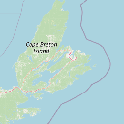
Map view of Big Glace Bay Lake National Wildlife Area

Use this park location map to pinpoint Big Glace Bay Lake National Wildlife Area in Canada, understand its exact geographic position, and read its mapped placement within the surrounding landscape more clearly.

Pigeon | © OpenStreetMap contributors

Location context for Big Glace Bay Lake National Wildlife Area

Nova Scotia
Park atlas

Compare regional protected areas and coastal landscapes

Parks Near Réserve nationale de faune du Lac-Big Glace Bay

Browse other parks near Réserve nationale de faune du Lac-Big Glace Bay to examine wider coastal habitats and protected landscapes across the surrounding region. Extending the geographic comparison reveals connected wetland ecosystems, regional bird refuges, and diverse maritime terrain.
National parkNova Scotia
About 63 km away#1 closest

Northwest

Cape Breton Highlands National Park: Mapped Protected Landscape in Nova Scotia

Discover its national park geography and natural terrain.

Uncover the protected landscape identity of Cape Breton Highlands National Park, a national park situated in Nova Scotia. This atlas-focused content details its mapped boundaries, regional geographic context, and natural terrain. It serves as a definitive resource for understanding the park's protected-area status and its contribution to the mapped natural landscapes of the region.

Area
949 km²
Established
1936
IUCN
II
Visitors
277.2K annual
Wildlife reserveNova Scotia
About 104 km away#2 closest

West

Sea Wolf Island National Wildlife Area: Protected Sandstone Cliffs and Seabird Sanctuary

Coastal maritime geography and nesting habitats in Nova Scotia

Sea Wolf Island National Wildlife Area constitutes a remote sandstone sanctuary in the Gulf of St. Lawrence. Characterized by steep, eroded cliff faces and isolated terrain, this Canadian protected area remains a significant site for colonial seabird nesting, specifically supporting populations of Great Cormorants and Razorbills within the Atlantic marine ecosystem.

Area
0.76 km²
Established
1982
IUCN
Ia
Wildlife reserveFrance
About 117 km away#3 closest

North

Réserve nationale de faune de l'Île-Saint-Paul Wildlife Reserve and Regional Geography

Mapping the protected landscapes of France

The Réserve nationale de faune de l'Île-Saint-Paul provides a focused look at isolated terrain and coastal environmental protection. As a designated wildlife reserve in France, it offers a distinct opportunity to study boundary-driven conservation and regional geography through a mapping perspective that highlights its remote natural character.

Established
2025
Relief
Lowland
Climate
Temperate
Access
Access unknown
Wildlife reserveNova Scotia
About 172 km away#4 closest

Southwest

Réserve nationale de faune de l'Île-Country: Nova Scotia Coastal Protected Area Geography

Mapped island habitats and protected Atlantic coastal terrain

Explore the protected landscape of Réserve nationale de faune de l'Île-Country, a 21-hectare wildlife reserve off the coast of Nova Scotia. This detailed overview focuses on the island's coastal mosaic of cobble ridges, shrub thickets, and meadow habitats that form a vital refuge for migratory seabird colonies within the Canadian Atlantic maritime region.

Area
0.21 km²
Established
2024
Relief
Lowland
Climate
Temperate
A wide watercolor illustration showing a landscape with green coniferous trees, tall grasses in the foreground, and soft rolling dunes in pastel pink and yellow hues in the background.
Wildlife reserveQuebec
About 197 km away#5 closest

Northwest

Réserve nationale de faune de la pointe de l'Est: Quebec Coastal Wildlife Reserve Atlas

A mapped complex of parabolic dunes, lagoons, and migratory bird habitats

Located on the Magdalen Islands, Réserve nationale de faune de la pointe de l'Est safeguards an exceptional coastal landscape defined by wind-shaped barrier spits and extensive sand dunes. This protected area offers critical insight into the geography of the Gulf of Saint Lawrence, protecting diverse habitats ranging from salt marshes to rare parabolic dune formations and freshwater wetlands.

Area
7.2 km²
Established
1978
IUCN
III
Relief
Lowland
National parkPrince Edward Island
About 211 km away#6 closest

West

Prince Edward Island National Park: A Mapped Protected Landscape within Canada's Maritime Region

Discover its geographic context and natural terrain.

Prince Edward Island National Park offers a distinct protected area for exploration within the Canadian Maritimes. As a national park, it represents a commitment to preserving specific natural landscapes and their geographic characteristics. This resource provides insight into its mapped boundaries, regional setting on Prince Edward Island, and its contribution to the broader atlas of protected lands.

Area
27 km²
Established
1937
IUCN
II
Relief
Lowland
National parkCanada
About 236 km away#7 closest

South

Sable Island National Park Reserve National Park: Mapped Protected Landscape and Geographic Context

Explore protected area boundaries and natural terrain in this Canadian national park.

Delve into the atlas-focused details of Sable Island National Park Reserve, a Canadian national park defined by its protected landscape identity. Understand its position within the broader geography of Canada, exploring its mapped terrain and the significance of its protected status for informed discovery. This entry provides core geographic and park data.

Area
30 km²
Established
2013
IUCN
II
Visitors
806 annual
A horizontal watercolor painting showing a pale green and soft pink landscape with distant hills, a calm body of water, and a tree-lined shore.
Wildlife reserveNew Brunswick
About 300 km away#8 closest

West

Réserve nationale de faune du Cap-Jourimain: Protected Coastal Wetlands and Wildlife Maps

Essential geographic context for a strategic New Brunswick wildlife reserve

Examine the mapped boundaries and complex ecosystem transitions of Réserve nationale de faune du Cap-Jourimain. This federally protected area in New Brunswick offers a distinct look at coastal marshlands, tidal flats, and island topography situated at the narrowest point of the Northumberland Strait.

Area
6.617 km²
Established
1980
IUCN
IV
Relief
Lowland

Common questions about visiting, size, designation, and location context for Big Glace Bay Lake National Wildlife Area

Big Glace Bay Lake National Wildlife Area FAQs for park facts, access, geography, and protected area context

Find quick answers about Big Glace Bay Lake National Wildlife Area, including protected-area facts, park geography, trail and visitor context, and how the park fits into its surrounding country and regional landscape.
MoriAtlas Explorer

Continue Your Protected Areas Search Across the Global Atlas

Deepen your exploration by continuing the structured search for national parks and protected areas worldwide. Utilize the comprehensive filtering capabilities to compare different conservation landscapes and refine your understanding of global park geography. Discover more about the distribution and characteristics of protected natural areas.

Global natural geography