Mori Atlas logo
National parkPrince Edward Island National Park

Discover the mapped boundaries and geographic context of this protected natural area.

Prince Edward Island National Park: Canada's Coastal National Park Protected Landscape

(Parc national de l'Île-du-Prince-Édouard)

Prince Edward Island National Park stands as a key protected landscape within the Canadian Maritimes. This national park is dedicated to preserving its unique coastal geography and natural terrain. Explore its mapped protected boundaries and understand its place within the regional atlas of natural areas. Access detailed geographic context to appreciate the full scope of this protected land.

coastal national parkred sand beachessand duneswetlandspiping plover habitatbirdwatching

Prince Edward Island National Park

National park

Park overview

Structured park overview, official facts, and landscape profile for Prince Edward Island National Park

Prince Edward Island National Park park facts, protected area profile, and essential visitor context
Review the core facts for Prince Edward Island National Park, including designation, size, terrain, visitor scale, habitats, and operating context in one park-focused overview.

About Prince Edward Island National Park

Prince Edward Island National Park occupies a unique position in Canada's national park system as a linear coastal reserve that follows the arc of the island's north shore along the Gulf of St. Lawrence. The park's establishment in 1937 marked the recognition of this coastline's exceptional natural and cultural value, and its subsequent expansion, particularly the 1998 addition of the Greenwich sand dune system, has strengthened protection of the most sensitive coastal habitats within its boundaries. The park's long, narrow configuration reflects the nature of the coastline it protects, a landscape shaped by wind, waves, and the gradual shifting of sands that have created extensive dune formations over millennia. Visitors to the park experience a landscape quite distinct from other Canadian national parks, where the absence of dramatic mountain terrain is replaced by the subtle beauty of coastal dunes, tidal marshes, and the warm glow of the island's famous red sand beaches. The park serves not only as a protected area but as a living cultural landscape where the rhythms of island life, agricultural heritage, and literary imagination converge.

Quick facts and research context for Prince Edward Island National Park

Prince Edward Island National Park is located on the north shore of Prince Edward Island province in Canada, with the nearest major city being Charlottetown. The park was established in 1937 and is administered by Parks Canada. It protects a chain of broad sand beaches, extensive sand dune systems, freshwater wetlands, and saltmarshes that run along the Gulf of St. Lawrence coastline. The park is considered the most endangered in Canada's national park system due to intensive human use and severe coastal erosion from winter storms. An important extension was added in 1998 when the Greenwich sand dune system was transferred from the provincial government to federal management.

Park context

Deeper park guide and search-rich context for Prince Edward Island National Park

Prince Edward Island National Park history, landscape, wildlife, and travel context
Explore Prince Edward Island National Park through its history, landscape character, ecosystems, wildlife, conservation priorities, cultural context, and seasonal travel timing in a structured park guide built for atlas discovery and search intent.

Why Prince Edward Island National Park stands out

Prince Edward Island National Park is best known for its iconic red sand beaches that stretch along the island's north coast, and for the dramatic sand dune systems that shape much of the shoreline. The park is also famous for protecting critical nesting habitat for the endangered piping plover, a shorebird that relies on the park's protected beaches for breeding. Culturally, the park is distinguished by its stewardship of Green Gables Heritage Place, the former farm that served as the childhood inspiration for L.M. Montgomery's Anne of Green Gables literature, which has made this corner of Prince Edward Island a destination for literary pilgrims from around the world.

Prince Edward Island National Park history and protected-area timeline

Prince Edward Island National Park was established in 1937 as part of Canada's growing national park system during the mid-20th century expansion of protected areas across the country. The initial park designation focused on protecting the significant beach and dune resources along the island's north shore, recognizing both their natural importance and their value to the province's identity and economy. In 1998, the park underwent a significant expansion when an extensive sand dune system at Greenwich was transferred from the provincial government to Parks Canada, adding substantially to the protected coastal habitat within the park's boundaries. The park includes two cultural heritage properties of note: Green Gables, a 19th-century farm that was the childhood home and inspiration for Lucy Maud Montgomery's Anne of Green Gables novels, and Dalvay-by-the-Sea, a Victorian-era mansion that now operates as a national park inn. In 1999, the Canadian Nature Federation identified Prince Edward Island National Park as the most endangered park in the Canadian national park system, primarily due to the intensive human use of its beaches and the ongoing challenge of coastal erosion from winter storms.

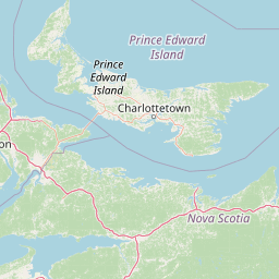
Prince Edward Island National Park landscape and geographic character

The landscape of Prince Edward Island National Park is defined by its coastal setting along the Gulf of St. Lawrence, where the interaction of wind, tides, and island geology has created a distinctive terrain of sand beaches, extensive dune systems, and tidal wetlands. The park's red sand beaches are perhaps its most recognizable feature, their characteristic colour deriving from the iron-rich soils that wash down from the island's interior and accumulate along the shoreline. Behind the beaches, sand dunes rise in varying heights, some stabilized by vegetation and others still active and shifting with the wind. The dune systems, particularly at Cavendish and Greenwich, represent some of the most significant coastal sand formations in Atlantic Canada. Between the dune ridges, freshwater wetlands and saltmarshes create ecologically rich zones where freshwater seeps meet tidal influences, supporting specialized plant and animal communities. The overall terrain is gentle and low-lying, reflecting the island's bedrock geology and its position as part of the larger Gulf of St. Lawrence coastal plain.

Prince Edward Island National Park ecosystems, habitats, and plant life

The nature of Prince Edward Island National Park is characterized by a complex mosaic of coastal habitats that support significant biodiversity despite the park's relatively small size. The sand dune systems represent a rare and sensitive habitat type in Atlantic Canada, hosting specialized plant species adapted to the harsh conditions of shifting sands, salt spray, and limited freshwater availability. The freshwater wetlands and saltmarshes within the park provide important ecological functions, serving as buffers between the terrestrial and marine environments while offering habitat for waterfowl, shorebirds, and amphibious species. The beaches themselves, while heavily used by visitors during summer months, also serve as critical nesting habitat for the endangered piping plover, a small shorebird that has become a symbol of the park's conservation challenges. The park's designation as a Canadian Important Bird Area reflects the significance of these coastal habitats for bird populations, both as nesting areas and as stopover points during migration along the Atlantic flyway.

Prince Edward Island National Park wildlife and species highlights

The wildlife of Prince Edward Island National Park reflects its position as a coastal ecosystem where marine, wetland, and terrestrial environments intersect. The park supports populations of common mammals including coyotes, red foxes, raccoons, North American beavers, American minks, and weasels, which inhabit the woodland edges, wetland areas, and open grasslands throughout the park. The birdlife is particularly diverse, with the park's wetlands and coastal areas providing habitat for numerous species including various herons, ducks, owls, cranes, plovers, grouses, jays, falcons, geese, hawks, sandpipers, and eagles. The endangered piping plover holds special significance, as the park's beaches provide essential nesting habitat for this species, which has faced significant population declines across its breeding range in eastern North America. Conservation efforts to protect piping plover nesting areas often involve temporary beach closures during the breeding season, creating a visible demonstration of the park's commitment to balancing visitor access with species protection.

Prince Edward Island National Park conservation status and protection priorities

Prince Edward Island National Park faces significant conservation challenges that have earned it the distinction of being identified as Canada's most endangered national park. The primary threats stem from the intensive human use of the park's beaches during the summer season, which places significant pressure on sensitive dune habitats and wildlife nesting areas, and from the ongoing process of coastal erosion driven by winter storms and sea-level changes. The protection of piping plover nesting habitat represents a particular conservation priority, requiring ongoing monitoring, public education, and seasonal access restrictions to ensure successful breeding. The park's management must balance the dual mandates of protecting natural heritage while providing meaningful visitor experiences, a challenge compounded by the popularity of the island's beaches and the cultural attractions at Green Gables. The 1998 addition of the Greenwich sand dune system strengthened the park's conservation base by bringing additional sensitive coastal habitat under federal protection, providing more space for natural processes to operate and reducing the pressure on existing park lands.

Prince Edward Island National Park cultural meaning and human context

Prince Edward Island National Park contains meaningful cultural heritage that connects the natural landscape to the province's literary and agricultural history. The Green Gables Heritage Place within the park preserves the farmstead that was home to Lucy Maud Montgomery during her childhood and that served as the setting and inspiration for her internationally beloved Anne of Green Gables novels. This connection has made the park a destination for literary pilgrims and fans of the Anne series, adding a cultural dimension to the park experience that extends beyond typical natural heritage interpretation. The Dalvay-by-the-Sea property, a Victorian-era mansion now operated as a park inn, represents another layer of the park's cultural landscape, reflecting the grand summer cottage tradition that emerged among Prince Edward Island's wealthy families in the late 19th century. These cultural elements are woven into a landscape that also retains evidence of the island's agricultural heritage, with farmland and pastoral scenes forming the backdrop to the coastal dunes and beaches that make the park distinctive.

Top sights and standout views in Prince Edward Island National Park

The highlights of Prince Edward Island National Park begin with its distinctive red sand beaches, which offer a visual and experiential signature unlike any other Canadian national park. The extensive sand dune systems at Cavendish and Greenwich provide dramatic coastal scenery and habitat for specialized plant communities. The park's role in protecting endangered piping plover nesting habitat demonstrates its conservation significance and offers visitors the opportunity to observe rare wildlife in a protected setting. The Green Gables Heritage Place provides a unique cultural dimension, connecting visitors to the literary heritage that has shaped Prince Edward Island's identity and global recognition. The Victorian charm of Dalvay-by-the-Sea adds another layer to the park's appeal, offering overnight accommodation in a historic setting. The park's linear configuration allows visitors to experience a variety of coastal environments, from wide sandy beaches to sheltered tidal marshes, within a single visit.

Best time to visit Prince Edward Island National Park

The best time to visit Prince Edward Island National Park depends on what visitors hope to experience. The summer months of July and August offer the warmest temperatures and full access to beach facilities, making this the most popular time for swimming and beach recreation, though visitors should be aware that the park's most famous beaches can become quite crowded during these peak weeks. The shoulder seasons of late spring and early fall offer a quieter experience with fewer visitors and the opportunity to observe migratory birds passing through the park's wetland habitats. Late spring and early fall also bring the breeding and nesting seasons for many bird species, including the endangered piping plover, when temporary closures may be in place to protect sensitive areas. Winter visits offer a dramatically different experience of the park, with stark dune landscapes and the power of winter storms visible along the coastline, though most visitor services are reduced during the off-season.

Park location guide

Geography guide, regional context, and park location map for Prince Edward Island National Park

Prince Edward Island National Park park geography, regions, and map view in Canada
Understand where Prince Edward Island National Park sits in Canada through a broader geographic reading of the surrounding landscape, nearby location context, and its mapped position within the national park landscape.

How Prince Edward Island National Park fits into Canada

Canada is a federal parliamentary constitutional monarchy spanning North America from the Atlantic to the Pacific and Arctic Oceans. With a population of over 41 million, it is officially bilingual in English and French at the federal level. The country gained independence from the United Kingdom through a gradual process culminating in 1982.

Wider geography shaping Prince Edward Island National Park in Canada

Canada occupies the northern portion of North America, sharing its longest international border with the United States. The country extends from the Atlantic Ocean to the Pacific Ocean and northward into the Arctic Ocean, giving it the longest coastline of any nation.

Map view of Prince Edward Island National Park

Use this park location map to pinpoint Prince Edward Island National Park in Canada, understand its exact geographic position, and read its mapped placement within the surrounding landscape more clearly.

Pigeon | © OpenStreetMap contributors

Location context for Prince Edward Island National Park

Prince Edward Island
Park atlas

Trace broader protected area geography and compare similar coastal landscapes across Atlantic Canada.

Explore Nearby National Parks and Protected Areas Beyond Prince Edward Island National Park
Browse a curated list of other national parks and protected areas near Prince Edward Island National Park, covering adjacent coastal regions and diverse conservation landscapes in Atlantic Canada. Expand your geographic understanding of protected areas by comparing features, scale, and ecological roles across the broader Maritime provinces.
National parkNew Brunswick

Kouchibouguac National Park: New Brunswick Protected Landscape Atlas

Mapped protected area boundaries and regional geography.

Kouchibouguac National Park is a designated national park offering a rich canvas for geographic discovery. This entry focuses on understanding its protected landscape, detailing its specific mapped boundaries within New Brunswick. It serves as a vital component for atlas exploration, providing the context needed to grasp the park's natural terrain and its significance within the regional geography.

Area
238 km²
Established
1969
IUCN
II
Visitors
243.5K annual
National parkNew Brunswick

Fundy National Park: New Brunswick National Park Atlas and Geographic Exploration

Mapped protected landscape and regional park context.

Fundy National Park represents a vital protected area, offering rich geographic discovery within New Brunswick, Canada. This national park detail provides context for its mapped boundaries and landscape, supporting atlas-based exploration of its regional significance. Understand Fundy National Park's protected status and its contribution to the mapped natural terrain of eastern Canada.

Area
207 km²
Established
1948
IUCN
II
Visitors
303.6K annual
National parkNova Scotia

Cape Breton Highlands National Park: Mapped Protected Landscape in Nova Scotia

Discover its national park geography and natural terrain.

Uncover the protected landscape identity of Cape Breton Highlands National Park, a national park situated in Nova Scotia. This atlas-focused content details its mapped boundaries, regional geographic context, and natural terrain. It serves as a definitive resource for understanding the park's protected-area status and its contribution to the mapped natural landscapes of the region.

Area
949 km²
Established
1936
IUCN
II
Visitors
277.2K annual
Watercolor painting showing a river landscape with green trees, rolling hills, and mountains in the background
National parkNova Scotia

Kejimkujik National Park: Detailed Protected Landscape and Regional Geography

Explore mapped boundaries and geographic context in Nova Scotia.

Kejimkujik National Park offers a dedicated entry for understanding protected natural areas. As a national park in Nova Scotia, its geographic features and protected boundaries are detailed here to support atlas-based exploration. Discover the park's unique landscape context and its positioning within regional geography, providing a factual basis for comprehending its role as a conservation area.

Area
404 km²
Established
1967
IUCN
II
Visitors
75.3K annual
National parkQuebec

Forillon National Park: Quebec National Park Protected Landscape and Geography

Explore mapped park boundaries and regional terrain.

Forillon National Park represents a crucial component of Quebec's protected lands, offering a rich subject for geographic discovery and atlas exploration. This national park's specific landscape characteristics and mapped boundaries provide essential context for understanding its role within the wider regional geography of Canada. Dive into the mapped terrain and protected area details that make Forillon National Park a unique element in any natural landscape atlas.

Area
244 km²
Established
1970
IUCN
II
Visitors
164.1K annual
National parkMinganie Regional County Municipality

Mingan Archipelago National Park Reserve: Mapped Protected Landscape

Discover its national park geography in Minganie

Mingan Archipelago National Park Reserve is a designated national park offering a distinct protected landscape within the Minganie Regional County Municipality. This entry provides core geographic context and mapped details crucial for atlas exploration. Understand the park's boundaries and its regional landscape setting for comprehensive discovery of Canada's protected natural areas.

Area
151 km²
Established
1984
IUCN
II
Visitors
44K annual
National parkMaine

Acadia National Park: A Protected Landscape within Maine's Regional Geography

Discover mapped boundaries and natural terrain context.

Delve into the protected landscape of Acadia National Park, a key entity within the geography of Maine. This dedicated atlas view helps you understand the park's mapped boundaries and its role within the broader regional context. Explore the natural terrain and understand how protected areas are situated geographically, enriching your understanding of conservation landscapes.

Area
198.6 km²
Established
1919
IUCN
V
Visitors
3.9M annual
National parkCanada

Gros Morne National Park: A Canadian National Park for Geographic Exploration

Discover its mapped protected boundaries and regional landscape context.

Explore Gros Morne National Park, a designated National Park within Canada, offering deep insights into its protected landscape and geographic significance. This page details its mapped boundaries and natural terrain, providing essential context for understanding its role within Canada's broader atlas of protected areas. Engage with the specific geography of this park to deepen your knowledge of natural landscapes and conservation.

Area
1,805 km²
Established
2005
IUCN
II
Relief
Mountain

Common questions about visiting, size, designation, and location context for Prince Edward Island National Park

Prince Edward Island National Park FAQs for park facts, access, geography, and protected area context
Find quick answers about Prince Edward Island National Park, including protected-area facts, park geography, trail and visitor context, and how the park fits into its surrounding country and regional landscape.
MoriAtlas Explorer

Continue Your Protected Areas Search Across the Global Atlas

Deepen your exploration by continuing the structured search for national parks and protected areas worldwide. Utilize the comprehensive filtering capabilities to compare different conservation landscapes and refine your understanding of global park geography. Discover more about the distribution and characteristics of protected natural areas.

Global natural geography