

Mori Atlas logo
Protected landscapeBlack Hill Conservation Park

Traversing steep ridge lines, dense she-oak woodlands, and critical heathland corridors

Black Hill Conservation Park: A Protected Landscape in the Mount Lofty Ranges of South Australia

Black Hill Conservation Park preserves a rugged stretch of the Mount Lofty Ranges, providing a crucial protected landscape near Adelaide. The terrain features sharp ridges and deep creek valleys characterized by dense she-oak woodlands and native heathland. As a vital component of the regional conservation corridor, this area offers extensive mapping of walking tracks, including sections of the Yurrebilla and Heysen trails, for those studying South Australian topography.

Mount Lofty RangesAdelaide Hillsconservation parkheathlandshe-oak woodlandbushwalking

Black Hill Conservation Park

Protected landscape

Park overview

Structured park overview, official facts, and landscape profile for Black Hill Conservation Park

Black Hill Conservation Park park facts, protected area profile, and essential visitor context

Review the core facts for Black Hill Conservation Park, including designation, size, terrain, visitor scale, habitats, and operating context in one park-focused overview.

About Black Hill Conservation Park

Black Hill Conservation Park is one of several near-city reserves that define the green edge of Adelaide's Mount Lofty Ranges. Covering approximately 7.58 square kilometres north of Fifth Creek between Athelstone and Montacute, the park occupies a compact but distinct stretch of ridge-and-valley terrain just a short drive from the South Australian capital.

Geographically, it sits within the broader Mount Lofty Ranges system that runs north to south along the eastern edge of Adelaide's coastal plain. The highest point, Black Hill Summit, reaches 467 metres, with steep ridges descending on both the northern and southern faces. The park shares a border with Morialta Conservation Park to the south, and together the two reserves form a continuous corridor of conserved bushland with closely related flora, geology, and climate.

Despite its modest size, the park is an important refuge for native vegetation in an otherwise suburbanised landscape. The dark-toned she-oak stands that once gave the hill its name still dominate large parts of the reserve, and the protected heathland within its boundaries supports wildlife that has disappeared from many surrounding areas. Because of its scale, location, and trail network, Black Hill functions both as a working conservation reserve and as a major recreational escape for Adelaide residents.

Quick facts and research context for Black Hill Conservation Park

Black Hill Conservation Park lies about 10 kilometres northeast of central Adelaide in the Mount Lofty Ranges and covers roughly 7.58 square kilometres. The park reaches a maximum elevation of 467 metres at Black Hill Summit, flanked by steep ridges on its northern and southern slopes.

Originally gazetted as Black Hill National Park on 27 January 1972, the area was reconstituted as a conservation park on 27 April 1972 under the National Parks and Wildlife Act 1972. Long-running protection history is reflected in its 1982 listing on the now-defunct Register of the National Estate.

Protection and recognition

Documented terrestrial protection records and designation details

Black Hill Conservation Park Protection Status and Administrative Scope

Black Hill Conservation Park maintains a documented terrestrial protection status within official administrative records. Verified conservation scope and formal designation metrics outline the operational framework governing the landscape.

Protection details

Protection scope
Terrestrial
Transboundary protection
No
Park context

Deeper park guide and search-rich context for Black Hill Conservation Park

Black Hill Conservation Park history, landscape, wildlife, and travel context

Explore Black Hill Conservation Park through its history, landscape character, ecosystems, wildlife, conservation priorities, cultural context, and seasonal travel timing in a structured park guide built for atlas discovery and search intent.

Why Black Hill Conservation Park stands out

Black Hill Conservation Park is best known for its extensive stands of she-oak woodland that give the hill its dark colouring, its network of bushwalking trails close to suburban Adelaide, and its position as a high-quality heathland habitat for native wildlife, including the endangered Mount Lofty Ranges chestnut-rumped heathwren. Many of the park's strongest trails, including sections of the Yurrebilla and Heysen long-distance routes, pass through these same slopes, linking Black Hill into a wider network of Mount Lofty Ranges reserves and trail experiences.
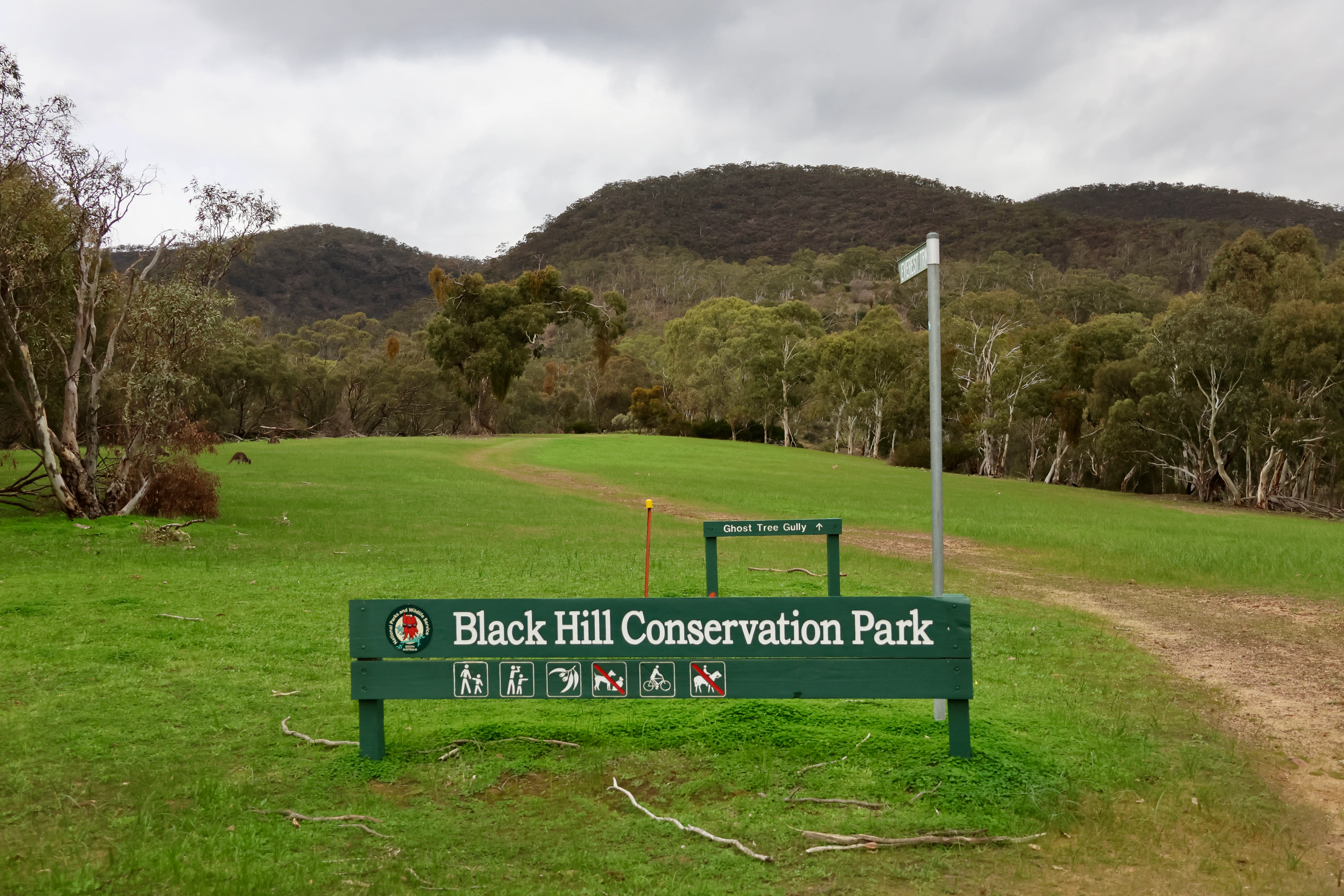
A green wooden sign displaying the name Black Hill Conservation Park in white text, situated on a grassy field in front of forested hills under an overcast sky.
The main entry sign for Black Hill Conservation Park, with hiking trails leading into the surrounding hills.

Black Hill Conservation Park history and protected-area timeline

The land that now forms Black Hill Conservation Park was first placed under formal public protection as Black Hill National Park on 27 January 1972, gazetted under the National Parks Act 1966. The reserve at that time covered defined sections within the cadastral units of the Hundred of Adelaide and the Hundred of Onkaparinga.

Just a few months later, on 27 April 1972, the national park was reconstituted as Black Hill Conservation Park under the newly enacted National Parks and Wildlife Act 1972. Since then the reserve has been managed as a conservation-focused protected area, with its current extent of approximately 7.58 square kilometres documented as of 2019.

A further recognition of its conservation significance came in 1982, when the park was listed on the Register of the National Estate. Although that register is no longer operative, the listing reflects the park's standing within South Australia's broader protected-area heritage. Volunteers associated with the Friends of the Black Hill and Morialta Conservation Parks continue to use the park's former nursery buildings for meetings and conservation work, including tending the historic Wildflower Garden in the park's south-east.

Black Hill Conservation Park landscape and geographic character

The landscape of Black Hill Conservation Park is shaped by the Mount Lofty Ranges, a north to south system of low mountains that runs along the eastern edge of Adelaide's coastal plain. Within this setting, the park occupies a compact ridge-and-valley block dominated by Black Hill Summit at 467 metres, with markedly steep slopes on both sides.

Much of the park sits north of Fifth Creek, with the valley systems of smaller creeks cutting back into the ridge and creating secluded pockets of vegetation. The park's boundaries are anchored by roads rather than dramatic natural limits: Gorge Road runs along the northern edge, while Montacute Road lies to the south, defining a reserve that feels natural and rugged on the inside but closely surrounded by suburban Adelaide.

Topography strongly influences the visitor experience here. Tracks climb from the lower elevations near Athelstone up toward the summit, with southern and northern ridges providing sharply distinct views in different directions. This combination of moderately steep terrain and proximity to suburbia gives Black Hill a feel that is at once wild and conveniently accessible.

Black Hill Conservation Park ecosystems, habitats, and plant life

Black Hill Conservation Park sits within a Mediterranean climate zone, with relatively mild winters averaging around 17 degrees Celsius and warm summers averaging about 28 degrees Celsius. Average annual rainfall is around 800 millimetres, with the bulk of precipitation arriving between May and September. Summer can occasionally bring extreme heat, with temperatures sometimes climbing above 40 degrees Celsius, shaping the rhythm of vegetation and wildlife activity through the year.

The park's vegetation reflects both its geology and its climate. Dense stands of she-oak, the Allocasuarina species whose dark foliage gives the hill its name, are a defining feature across much of the reserve. Beneath and beyond these she-oak woodlands, the protected heathland communities of the Mount Lofty Ranges are a particular conservation priority, supporting plant species adapted to nutrient-poor soils and seasonal dryness.

The park is classified as an IUCN Category III protected area (natural monument or feature), a designation that underlines the importance governments place on its individual landform and ecological character. The historic Wildflower Garden in the park's south-east, originally established in the 1940s as a native flora nursery, remains an enduring reminder of the region's long association with native plant cultivation, even though soil contamination by Phytophthora cinnamomi has prevented the site from operating as an active nursery since the 1970s.

Black Hill Conservation Park wildlife and species highlights

Wildlife in Black Hill Conservation Park is closely tied to its heathland and she-oak woodland habitats, which provide refuge for a remarkable range of species relative to the park's small size.

The park is particularly notable for hosting populations of the endangered Mount Lofty Ranges chestnut-rumped heathwren, a subspecies that depends heavily on the high-quality heath habitat found within the reserve. Beyond this flagship species, the park's mix of dense vegetation, open heath, and sheltered creek corridors creates conditions that favour a broad community of birds and smaller fauna typical of the Mount Lofty Ranges.

The park's botanical character also supports a butterfly and pollinator community, with native species such as the Australian painted lady recorded feeding on native wildflowers, including orchid species, inside the reserve. Combined, these wildlife values reinforce the park's role as an important refuge for native fauna within a landscape otherwise heavily shaped by suburban Adelaide.

Black Hill Conservation Park conservation status and protection priorities

Black Hill Conservation Park's principal conservation value lies in its role as a refuge of high-quality heathland and she-oak woodland within an urbanising region. In real terms, this means that species and vegetation communities that have been lost or diminished across much of the surrounding Mount Lofty Ranges foothills continue to find a stronghold within the reserve.

The park's biodiversity significance is formally recognised through its IUCN Category III status (natural monument or feature), as well as by its listing on the Register of the National Estate in 1982. These designations highlight Black Hill as more than just a recreational green space: it is an area identified as holding important natural heritage values at both state and national levels.

Conservation effort in the park has evolved alongside its administrative history. After its gazetting as a national park in early 1972, the reserve was quickly reconstituted as a conservation park in April 1972 under then-new wildlife-focused legislation. Volunteer groups, especially the Friends of the Black Hill and Morialta Conservation Parks, remain active in the reserve, supplementing official management through habitat work, weed management, and the maintenance of the historic Wildflower Garden amid the ongoing challenge of Phytophthora cinnamomi contamination in the soil.

Black Hill Conservation Park cultural meaning and human context

The broader Adelaide Plains, including the country that now makes up Black Hill Conservation Park, are the traditional lands of the Kaurna people. Although most Kaurna elders had died by the time systematic recording of their culture was undertaken, surviving evidence indicates that the Kaurna used fire both as a hunting tool and as a way of stimulating vegetation regeneration, a practice that shaped the pre-colonial landscape across much of the Mount Lofty Ranges foothills.

The Kaurna presence in the park is therefore part of a much wider regional heritage rather than a single localised story, and detailed pre-colonial cultural continuity within the reserve itself is largely unrecorded.

More recent cultural layers include the role of local volunteer associations, particularly the Friends of the Black Hill and Morialta Conservation Parks, whose members use the old Wildflower Garden nursery buildings for meetings and habitat-related activities, weaving community engagement into the park's ongoing identity.

Top sights and standout views in Black Hill Conservation Park

Black Hill Conservation Park's strongest draws are its close-to-Adelaide accessibility, its network of marked walking trails linking peaks, valleys, and creek lines, and its stretches of long-distance tracks including the Yurrebilla Trail and Heysen Trail. The summit view, the surrounding steep ridges, and the dark she-oak slopes reinforce a sense of immersion in Mount Lofty Ranges bushland despite the park's modest footprint.

Equally distinctive is the park's protected heathland, which sustains species like the endangered Mount Lofty Ranges chestnut-rumped heathwren and contributes to the broader Morialta-Black Hill corridor of conserved native bush. The historic Wildflower Garden in the south-east of the park adds a tangible human layer that visitors and volunteers continue to engage with.

Best time to visit Black Hill Conservation Park

Black Hill Conservation Park, like much of the Mount Lofty Ranges near Adelaide, is most comfortable to explore in the cooler and greener months between late autumn and early spring, when rainfall is concentrated and the bushland is at its freshest. Winter temperatures averaging around 17 degrees Celsius make walking the network of trails, including the Yurrebilla and Heysen route sections, generally pleasant.

Summer brings warm conditions, with averages near 28 degrees Celsius and occasional extremes above 40 degrees Celsius, which can make exposed ridge walks demanding. Spring tends to be rewarding for wildflowers and bird activity, while autumn offers quieter tracks and stable weather. Morning starts are advisable whenever temperatures climb, and visiting after substantial rain can make some trails slippery.

Monthly climate preview

Long-term representative monthly temperature and precipitation averages for South Australia

Black Hill Conservation Park Climate Normals and Annual Weather Patterns

Black Hill Conservation Park exhibits a measured annual cycle of temperature and precipitation based on long-term representative coordinate data. Examining the complete monthly climate profile reveals detailed seasonal variations in regional averages and precipitation rates.
Annual mean16 °C
10 °C22 °C
Jan22°
Feb22°
Mar20°
Apr16°
May13°
Jun11°
Jul10°
Aug10°
Sep12°
Oct15°
Nov18°
Dec20°
Warmest month
January

22.1 °C

Coolest month
July

9.8 °C

Wettest month
June

2.2 mm/day

Driest month
January

0.5 mm/day

Park location guide

Geography guide, regional context, and park location map for Black Hill Conservation Park

Black Hill Conservation Park park geography, regions, and map view in Australia

Understand where Black Hill Conservation Park sits in Australia through a broader geographic reading of the surrounding landscape, nearby location context, and its mapped position within the national park landscape.

How Black Hill Conservation Park fits into Australia

Australia is a constitutional monarchy and federal parliamentary democracy comprising six states and ten territories. With a population of nearly 28 million, it is one of the world's most urbanised countries, with most people concentrated on the eastern seaboard. The country has a high Human Development Index and is known for its cultural diversity, ancient Aboriginal heritage, and unique wildlife.

Wider geography shaping Black Hill Conservation Park in Australia

Australia occupies the entire Australian continent, the island of Tasmania, and numerous smaller islands. It is the world's flattest and driest inhabited continent, featuring vast deserts in the interior (the Outback), tropical rainforests along the eastern coast, and a coastline bordering the Indian and Pacific Oceans.

Map view of Black Hill Conservation Park

Use this park location map to pinpoint Black Hill Conservation Park in Australia, understand its exact geographic position, and read its mapped placement within the surrounding landscape more clearly.

Pigeon | © OpenStreetMap contributors

Location context for Black Hill Conservation Park

South Australia
Recorded earthquake history

Browse the Historical Earthquake Catalogue for Black Hill Conservation Park

Explore a detailed record of past seismic events associated with the geography of Black Hill Conservation Park. This collection provides researchers and visitors with indexed event data including magnitude and epicentre distance, offering a transparent look at the historical seismic activity documented in the Mount Lofty Ranges area.

Black Hill Conservation Park Earthquake History

Catalogued events

6 events

Strongest magnitude

Magnitude 4

Most recent event

Mar 29, 2022

This history includes earthquakes recorded inside the park or within 50 km of its borders

Visual reference guide featuring ridge terrain, she-oak woodland, and native habitats

Black Hill Conservation Park Photos and Protected Landscape Scenery

Visual records capture the rugged ridge systems, dark she-oak woodlands, and steep creek valleys that define the protected landscape. Examining field photography reveals the complex topography and native vegetation patterns that shape the surrounding conservation reserve.

A green wooden sign displaying the name Black Hill Conservation Park in white text, situated on a grassy field in front of forested hills under an overcast sky.

Park atlas

Compare regional reserves and connected bushland corridors across the Mount Lofty Ranges.

Parks Near Black Hill Conservation Park And Surrounding Protected Landscapes

Browse nearby protected areas to compare ridge systems and valley flora adjacent to Black Hill Conservation Park. Extending your geographic review reveals how contiguous conservation corridors connect local habitats across the surrounding region.
Nature reserveSouth Australia
4.2 km away#1 closest

South

Giles Conservation Park: Protected Nature Reserve and Adelaide Hills Geography Map

Exploring native woodland terrain and regional trail corridors

Giles Conservation Park protects a significant pocket of remnant eucalypt woodland within the Adelaide Hills of South Australia. Located near Norton Summit, the reserve preserves native habitats that support western grey kangaroos and koalas while providing a key segment for the Heysen and Yurrebilla long distance walking trails. This landscape is a fundamental part of the foothills ecosystem and a notable feature in local topographic study.

Area
1.09 km²
Established
2007
IUCN
III
Water
Minor water
Nature reserveSouth Australia
About 5 km away#2 closest

South

Horsnell Gully Conservation Park: Geographic Overview and Protected Landscape Mapping

Rugged gorges and native woodland in the Adelaide Hills

Horsnell Gully Conservation Park offers a dense concentration of natural features, including dramatic ridgelines and seasonal water flow, within the Mount Lofty Ranges. This protected area serves as a key segment of the Heysen Trail, highlighting its role in the regional geography of South Australia. Learn about the physical landforms and ecological character of this urban-adjacent nature reserve.

Area
1.37 km²
Established
1947
IUCN
III
Relief
Mountain
National parkAdelaide Hills
About 8.9 km away#3 closest

South

Cleland National Park: Mapped Protected Landscape and Regional Geographic Context

Discover the natural terrain and park boundaries within Adelaide Hills.

Cleland National Park offers a critical lens into the protected landscapes of South Australia's Adelaide Hills. As a national park, its mapped boundaries and geographic position are key elements for understanding regional natural terrain. This resource facilitates atlas-style exploration of Cleland National Park, highlighting its importance within the conservation framework and providing a foundation for detailed geographic study.

Area
11.25 km²
Established
1945
IUCN
II
Visitors
100K annual
Nature reserveSouth Australia
About 9 km away#4 closest

East

Cudlee Creek Conservation Park: Geography, Protected Boundaries, and South Australian Terrain

Adelaide Hills nature reserve with riparian forest and eucalypt woodland habitat

Cudlee Creek Conservation Park provides a clear look at the Adelaide Hills landscape through its mix of steep stringybark forest and River Torrens riparian habitat. This small nature reserve serves as an important regional reference site for native plant communities and bird habitat within the context of a heavily altered agricultural landscape in South Australia.

Area
0.49 km²
Established
1971
IUCN
III
Relief
Upland
National parkSouth Australia
13 km away#5 closest

South

Belair National Park National Park: South Australia Protected Landscape and Map Exploration

Explore the geographic context and mapped boundaries of this South Australian protected area.

Belair National Park represents a significant protected land entity within South Australia, offering specific geographic insights relevant to atlas exploration. As a designated national park, its mapped boundaries and landscape character are essential for understanding regional conservation efforts. This profile provides foundational information on the park's identity as a protected natural area, anchoring its position within the geography of South Australia for detailed map-based discovery and regional context.

Area
8.35 km²
Established
1891
IUCN
II
Visitors
358.6K annual
Nature reserveSouth Australia
About 20 km away#6 closest

East

Charleston Conservation Park: Geography and Woodland Transitions in the Adelaide Hills

Explore protected terrain in South Australia

Charleston Conservation Park stands as an important ecological remnant in the Adelaide Hills. Its 54 hectares offer a concentrated look at woodland associations ranging from sheoak groves to blue gum forest and silver banksia stands. Use this atlas resource to understand the park's topography, its role in the Mount Lofty Ranges, and its contribution to regional conservation efforts.

Area
0.54 km²
Established
1976
IUCN
III
Relief
Upland
National parkSouth Australia
21 km away#7 closest

Southwest

Glenthorne National Park, Ityamaiitpinna Yarta: Exploring South Australia's National Park Geography

Understand the park's protected landscape and mapped context.

Glenthorne National Park, Ityamaiitpinna Yarta represents a key protected area within South Australia, offering focused insights into its geographic placement and landscape characteristics. As a national park, it serves as an important entity for understanding regional natural landscapes and the mapped distribution of protected lands across the state. Explore its specific context within South Australia's broader geography.

Established
2020
Scope
Terrestrial
Water
Minor water
Nature reserveSouth Australia
23 km away#8 closest

Northeast

Hale Conservation Park: Nature Reserve and Geological Landmark in South Australia

Protected forest landscapes in the Mount Lofty Ranges

Located near Williamstown, Hale Conservation Park preserves a rugged stretch of hilly terrain representative of the broader Mount Lofty Ranges. This nature reserve serves as a sanctuary for stringybark forest and provides scientists and map enthusiasts with clear evidence of a regional geological unconformity.

Area
1.89 km²
Established
1964
IUCN
III
Relief
Mountain

Common questions about visiting, size, designation, and location context for Black Hill Conservation Park

Black Hill Conservation Park FAQs for park facts, access, geography, and protected area context

Find quick answers about Black Hill Conservation Park, including protected-area facts, park geography, trail and visitor context, and how the park fits into its surrounding country and regional landscape.
MoriAtlas Explorer

Continue Your Protected Areas Search Across the Global Atlas

Deepen your exploration by continuing the structured search for national parks and protected areas worldwide. Utilize the comprehensive filtering capabilities to compare different conservation landscapes and refine your understanding of global park geography. Discover more about the distribution and characteristics of protected natural areas.

Global natural geography