
Mori Atlas logo
Nature reserveBlaue Kuppe

Mapping the volcanic intrusion and protected rock habitats of this northern Hesse natural monument

Blaue Kuppe Nature Reserve: A Geological Basalt Landmark in the Werra-Meißner-Kreis Region

The Blaue Kuppe nature reserve stands as a classic basalt hill near Eschwege in the Werra-Meißner-Kreis. Rising above the surrounding agricultural fields, this protected site preserves a textbook example of volcanic intrusion and contact metamorphism where basalt meets Triassic Buntsandstein sandstone. Beyond its historical role in geological science, the reserve maintains essential nutrient-poor grassland and unique rock-dwelling plant communities within its historic quarry pits.

geotopebasalt hillvolcanic intrusioncontact metamorphismold quarrynature reserve
A stylized digital illustration of a prominent rocky cliff featuring a vertical waterfall, surrounded by pine trees and distant rolling hills under a bright sun.

Blaue Kuppe

Nature reserve

Park overview

Structured park overview, official facts, and landscape profile for Blaue Kuppe

Blaue Kuppe park facts, protected area profile, and essential visitor context

Review the core facts for Blaue Kuppe, including designation, size, terrain, visitor scale, habitats, and operating context in one park-focused overview.

About Blaue Kuppe

Blaue Kuppe lies in a gently rolling agricultural landscape of the Eschweger Hügelland, on the boundary between the town of Eschwege and the village of Langenhain in Wehretal. Although it reaches only about 309 meters above sea level and rises modestly above its surroundings, it is geologically one of the most instructive volcanic features in northern Germany, and it sits within the Geo-Naturpark Frau-Holle-Land, a landscape defined by deep geological history and the folklore of Frau Holle.

The hill is the eroded remnant of a Miocene basalt intrusion that pushed upward through fracture zones but never reached the Miocene surface. Instead, the magma solidified underground into alkaline olivine basalt rich in vesicles and flow textures. Over millions of years, erosion stripped away the softer sandstone and tuff that once surrounded and capped the basalt plug, leaving the harder volcanic rock standing as a steep, conical hill. Today the basalt lies roughly 100 meters below the position of the ancient land surface it once intruded.

What makes the outcrop especially important is the boundary between the dark basalt and the bright, originally red Buntsandstein. The heat of the intruding magma bleached the sandstone and produced a contact-metamorphic rock called buchite, with zones where basalt lava, tuff breccia, vesicular slag tuff, and shattered sandstone blocks are mingled along the old quarry walls. These exposures were once accessible in deep working quarries, and the pits that remain now frame isolated basalt pillars and reveal the contact zones that drew generations of geologists to the site.

Although Blaue Kuppe is a tiny site by the standards of most protected areas, it has earned a place in the history of science. In the early 19th century, the hill became a battleground between opposing schools of geological thought. Neptunists argued that basalt formed as a marine sediment, while Plutonists insisted that it was the product of volcanic activity. The hill provided evidence for both camps, giving rise to an extensive early geological literature. Karl Cäsar von Leonhard, Johann Carl Wilhelm Voigt, Lorenz Oken, and Alexander von Humboldt all described the site in their writings, and the mineralogist Paul Ramdohr completed his 1919 doctoral dissertation on the basalt and its mineral assemblage.

Modern conservation at Blaue Kuppe reflects both its scientific and its ecological value. The hill is recognized as a schützenswertes Geotop (geotope worthy of protection), part of the geological heritage of Hesse, and the wider 6.75-hectare reserve protects plant communities that depend on warm, open conditions. Quarrying was halted when the significance of the outcrop became clear, and subsequent legal protections, including entry into the imperial nature protection register in 1939 and designation as a nature reserve in 1969, have ensured that both the rocks and their associated habitats can be studied and observed in the form they have taken since the last stones left the quarry.

Quick facts and research context for Blaue Kuppe

Blaue Kuppe is a forested hill rising roughly 295 to 314 meters above sea level, situated about four kilometers south of Eschwege in the Werra-Meißner-Kreis of northern Hesse. The site covers approximately 6.75 hectares and is registered under the German national identifier 1636006 with the World Database on Protected Areas entry WDPA 81414.

It carries a double protected status: it is a designated Naturdenkmal (natural monument) and a Naturschutzgebiet (nature reserve) within the Geo-Naturpark Frau-Holle-Land. Its national nature monument number in the Werra-Meißner-Kreis is ND 636.647.

Protection and recognition

Documented terrestrial protection scope and historical designation data

Blaue Kuppe Protection Status and Official Designation History

Terrestrial protection status for Blaue Kuppe originates from official designation records established in 1969. Official database registries track the documented management history and administrative framework for this protected landscape.

Protection details

Protection scope
Terrestrial
Designated year
1969
Transboundary protection
No
WDPA ID
81414
Park context

Deeper park guide and search-rich context for Blaue Kuppe

Blaue Kuppe history, landscape, wildlife, and travel context

Explore Blaue Kuppe through its history, landscape character, ecosystems, wildlife, conservation priorities, cultural context, and seasonal travel timing in a structured park guide built for atlas discovery and search intent.

Why Blaue Kuppe stands out

Blaue Kuppe is best known as a classic example of a volcanic basalt plug preserved where it intruded into Triassic Buntsandstein sandstone, exposing textbook contact metamorphism between lava and sedimentary rock. The hill gave the 19th-century Neptunist-Plutonist debate one of its most-cited field examples. The site is also recognized for its mineralogical richness: post-eruption fumaroles deposited about 25 different minerals, including rare specimens such as cristobalite crystals whose quality has been described as among the finest in the world.
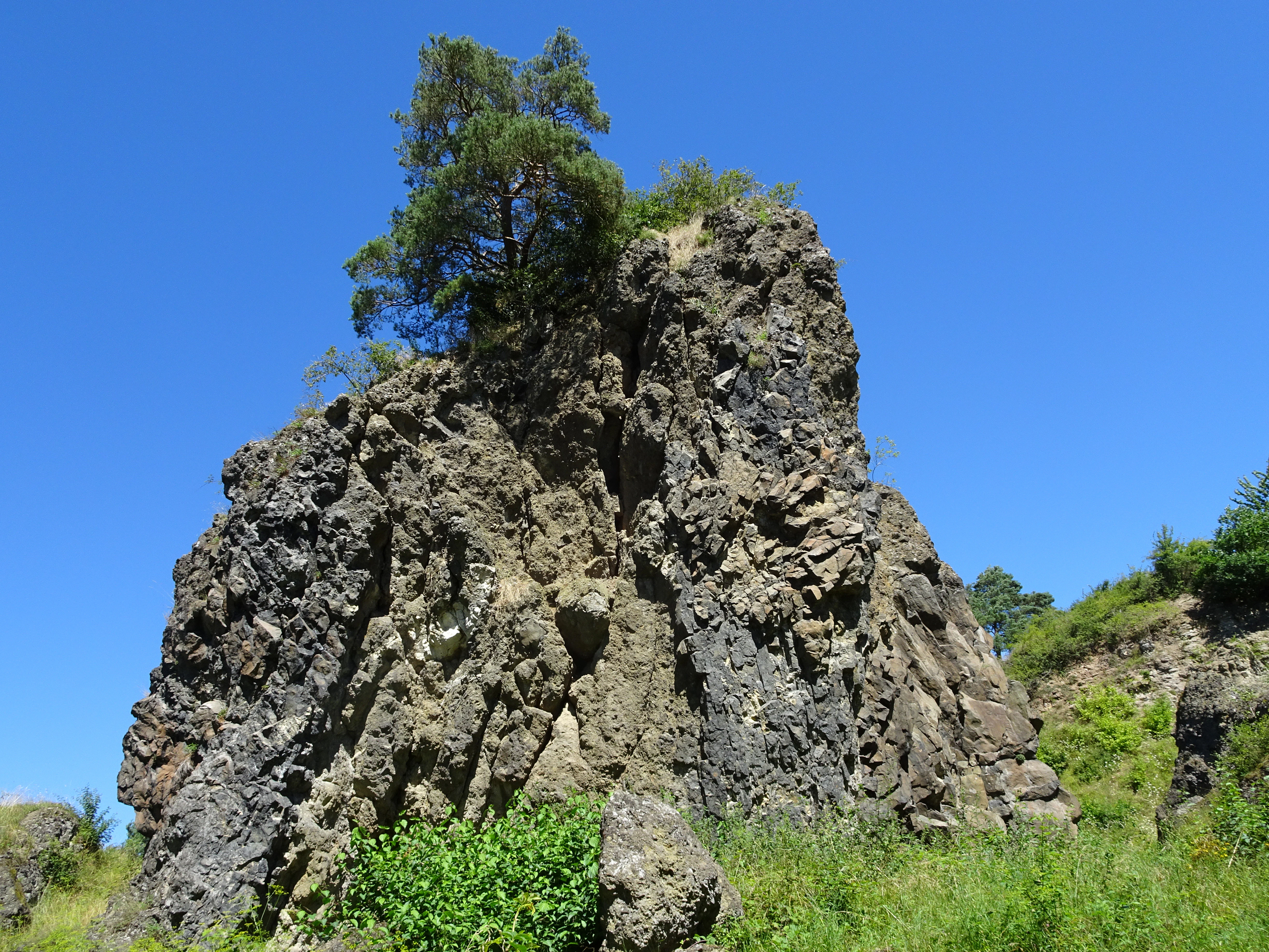
A large, rugged, dark-grey volcanic rock formation stands prominently against a clear blue sky, with a small tree growing at its peak and green vegetation at its base.
The basalt rock formation at Blaue Kuppe, a former volcanic vent in Hesse, Germany.

Blaue Kuppe history and protected-area timeline

Although the precise beginning of basalt extraction at Blaue Kuppe is unknown, documents from the city of Eschwege show that stone was being hauled away from the hill shortly after 1800. By the early 20th century, the basalt belonging to the town had been largely quarried away, and only the scientific and aesthetic value of what remained stood between the hill and complete destruction.

Protection came in stages. The town of Eschwege agreed to safeguard the site in 1910 after the regional geological survey and the state office for natural monument care jointly petitioned for its preservation. A renewed attempt to quarry gravel for road construction was defeated in 1919. In September 1939 a decree of the Regierungspräsident in Kassel entered Blaue Kuppe into the Reichsnaturschutzbuch and placed it under the Reich Nature Protection Act. With the entry into force of the Bundesnaturschutzgesetz in December 1976, the site was continued in protection as a legally binding individual natural creation under federal law.

In parallel, the hill gained formal nature reserve status. On 17 February 1969, the Regierungspräsident in Kassel, acting as the higher nature protection authority, issued the ordinance establishing the Blaue Kuppe Naturschutzgebiet. The reserve covers 6.75 hectares and carries the national code 1636006. The site is also listed in the natural monument register of the Werra-Meißner-Kreis under the number ND 636.647. As a result of these protections, the removal of minerals, rocks, or other material is now prohibited, ensuring that the productive contact zones and mineralized cavities of the old quarry will not be further depleted.

Blaue Kuppe landscape and geographic character

Blaue Kuppe is a small, conical, forested hill rising only modestly above an otherwise open, agricultural landscape of the Eschweger Hügelland. Its summit lies around 309 meters above sea level, and the protected hill itself spans elevations roughly between 295 and 314 meters. In this rolling terrain, the hill reads as a dark, wooded mark on the horizon and as a subtle but distinctive interruption of the surrounding fields.

The defining topographic feature of the site is not the hilltop itself but the two roughly circular quarry pits, or Kessel, that were excavated into its flanks during the 19th and early 20th centuries. These pits now serve as frames around the surviving basalt pillars and exposed contact zones between basalt lava and Buntsandstein sandstone. Quarried walls and isolated columns of darker rock punctuate the slopes, while the surrounding landscape continues as farmland.

From the hill it is possible to look northwest toward the Hoher Meißner, one of the most prominent landmarks of northern Hesse, and southward into the Wehretal toward Reichensachsen. The hill is bordered to the east by the L 3424 state road, and a cycle and farm track passes along its southern side. A small stream, the Leimbach, rises just south of the hill and flows westward into the Wehre.
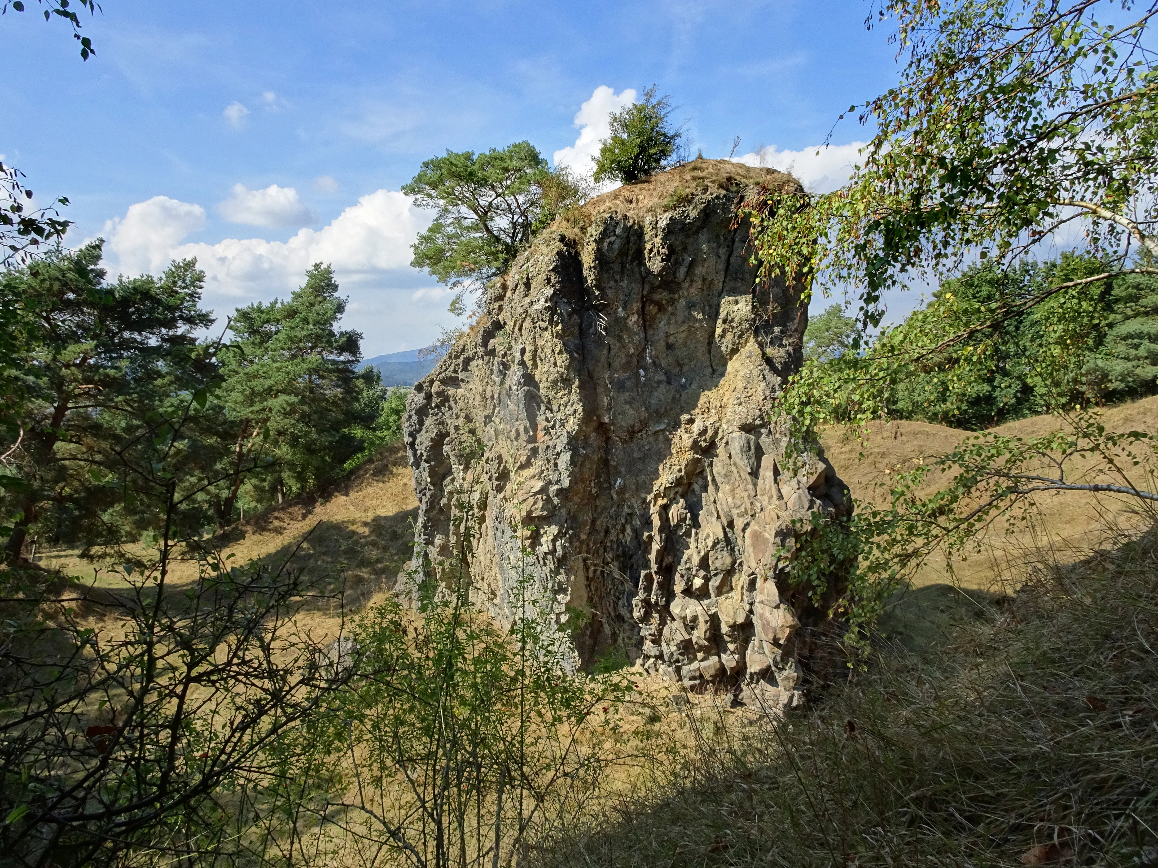
A prominent, weathered basalt rock pillar stands in a grassy, open area surrounded by trees and vegetation at the Blaue Kuppe site.
A remnant basalt rock formation at the Blaue Kuppe nature reserve.

Blaue Kuppe ecosystems, habitats, and plant life

Although Blaue Kuppe is tiny in size, its ecological character is strongly shaped by the geology beneath it. The combination of basalt rock, sandy weathering products, and the warm microclimate of the former quarry pits creates conditions for plant communities that are notably different from the surrounding farmland. Open rock and scree vegetation, together with nutrient-poor grassland (Magerrasen), are among the principal habitats protected here.

In the quarry pits, vegetation is sparse and frequently threatened by encroaching shrubs and developing woodland. The reserve is therefore actively managed to keep these open conditions: sheep are used to graze the area and bushes are cleared at intervals, sustaining the warm-loving, light-dependent species that depend on persistent gaps in the canopy.

The protected area is classified in the IUCN system as a Category IV Habitat/Species Management Area, recognizing both its habitat value and the active management required to keep the rock and grassland communities viable. The site is not primarily a forest reserve, although the hill itself is wooded, and its biodiversity value lies above all in the unusual combination of volcanic rock, dry grassland, and historically disturbed quarry terrain.
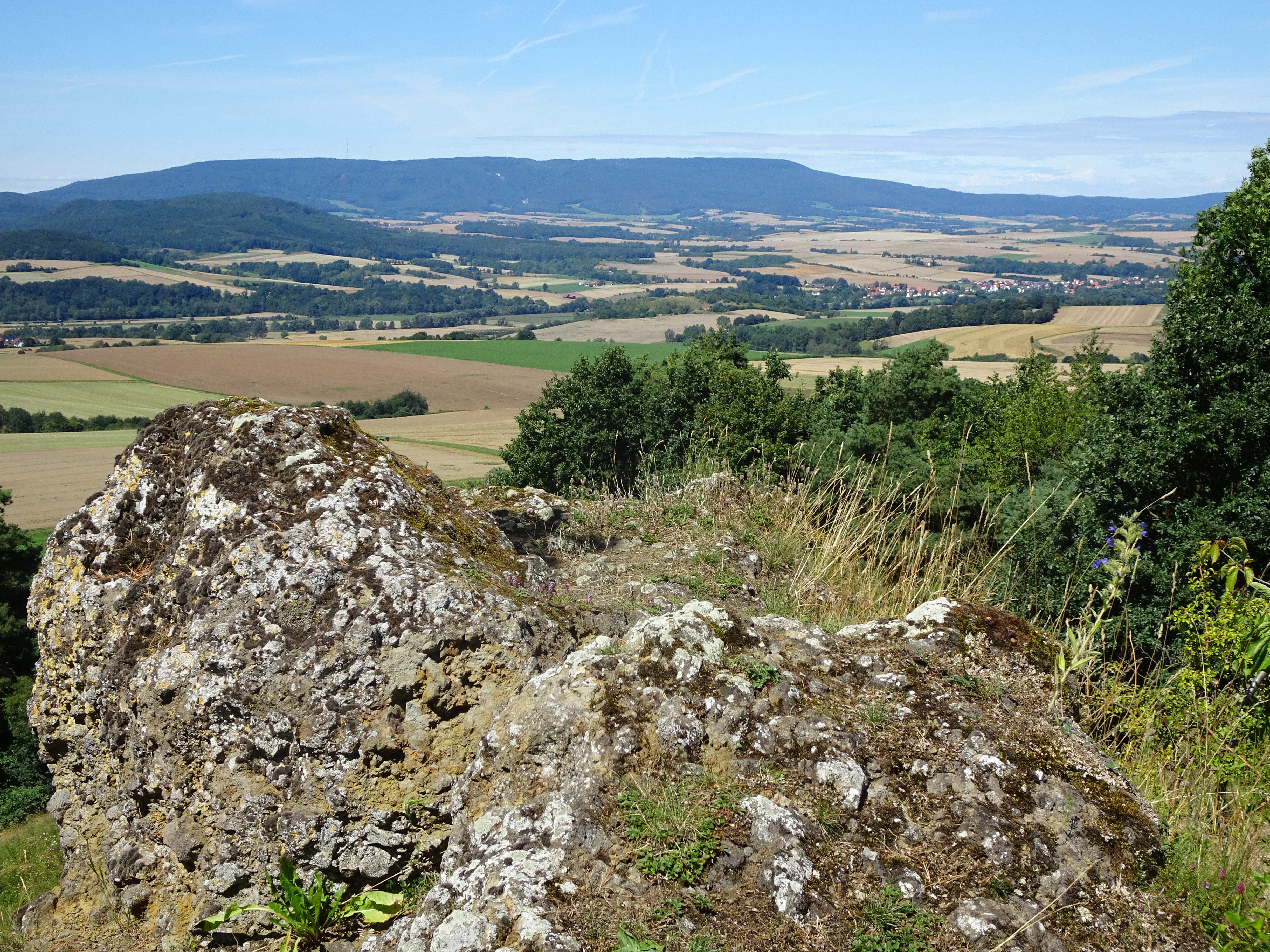
A high angle view over a rolling rural landscape with agricultural fields and distant hills, with moss-covered, textured volcanic basalt boulders in the immediate foreground.
A view overlooking the landscape of the Blaue Kuppe region, featuring prominent basalt rock formations in the foreground.

Blaue Kuppe wildlife and species highlights

The available sources do not provide a focused description of distinct animal communities at Blaue Kuppe, and the park is small enough that wildlife writing should focus on habitat rather than species lists. The quarry pits and their sparse, warm grasslands provide habitat for invertebrates and other small fauna typical of such open, rocky terrain in Hesse.

The reserve explicitly permits the continued legal exercise of hunting and traditional agricultural and forestry use, indicating that any larger mammal presence is treated primarily in the context of land management rather than as a feature of the protected site. More detailed wildlife data was not available in the source materials, and this section should not be padded with unsupported species claims.
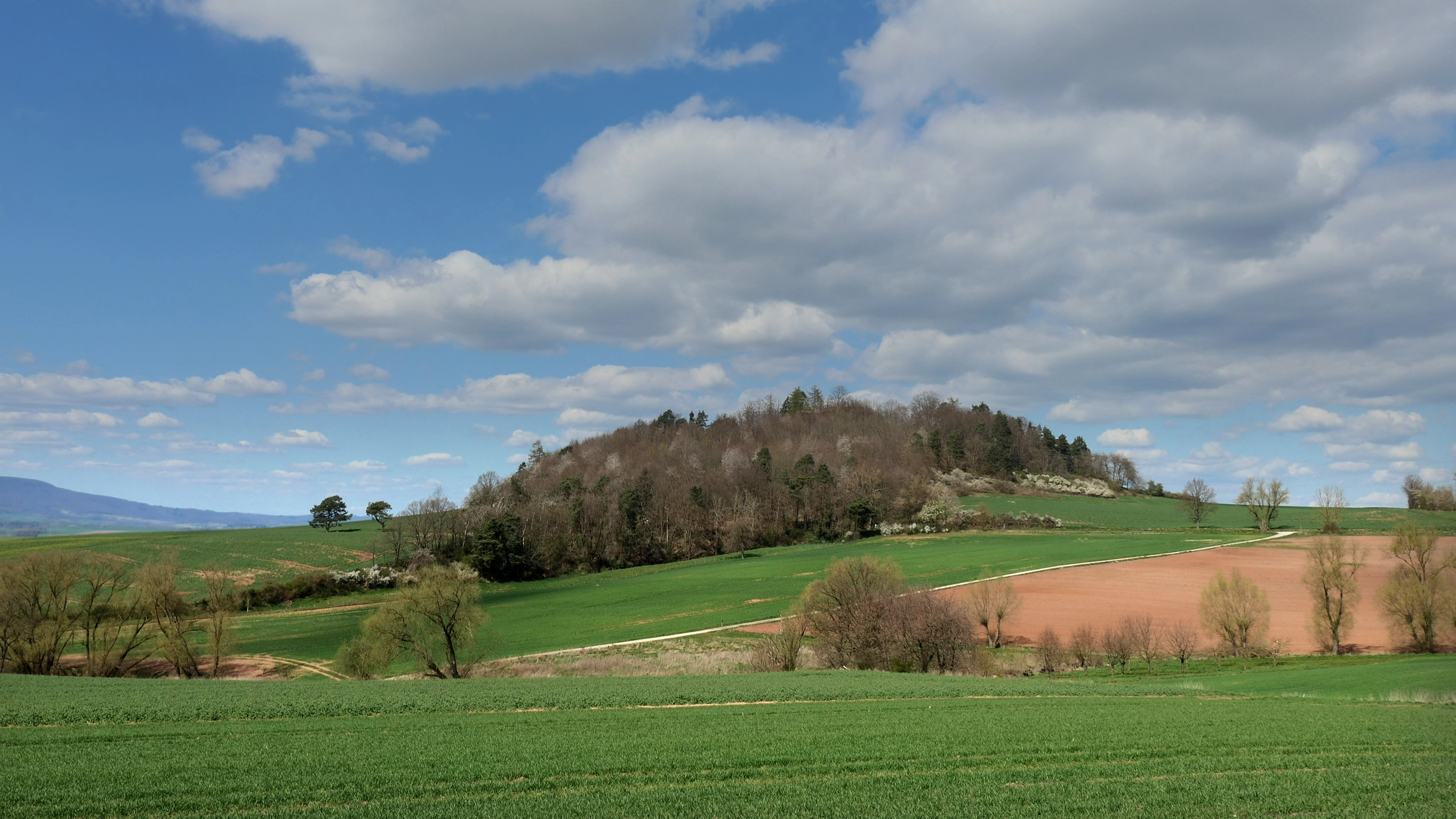
A wide shot of a forested hill, the Blaue Kuppe, rising above green agricultural fields under a blue sky with scattered clouds.
A wide view of the Blaue Kuppe geological landmark in Hesse, Germany.

Blaue Kuppe conservation status and protection priorities

Blaue Kuppe carries a layered conservation status that reflects both its scientific importance and its ecological value. The site is registered in the World Database on Protected Areas as entry 81414 and classified as an IUCN Category IV Habitat/Species Management Area. Within Germany it is protected both as a Naturdenkmal (natural monument) and as a Naturschutzgebiet (nature reserve), with the hill itself further embedded in the geological protection framework of the Geo-Naturpark Frau-Holle-Land.

The conservation rationale is unusually explicit. Blaue Kuppe is recognized as a Geotop, a geological heritage site worthy of protection, because it provides insights into Earth history that cannot be obtained from intact, unexposed geological formations. The Hessen state soil research institute previously singled out the hill, together with five other geotopes in the Kassel administrative region, from among 450 documented geotopes in Hesse, underscoring its regional significance. The protection of the contact zones between basalt and Buntsandstein, of buchite formed by contact metamorphism, and of the rare mineral assemblage are central to this designation.

Ecologically, the reserve protects a vulnerable mosaic of rock and scree vegetation and nutrient-poor grassland that depends on the warm microclimate of the old quarries. Because natural succession and forest encroachment threaten these open communities, grazing with sheep and targeted bush removal are used as management tools, all framed by the 1969 ordinance that prohibits any action likely to alter or impair the natural character of the area.

Blaue Kuppe cultural meaning and human context

Blaue Kuppe sits within the cultural landscape of the Werra-Meißner-Kreis, an area steeped in the folklore of Frau Holle. The hill is part of the Geo-Naturpark Frau-Holle-Land, named for the fairy-tale figure and rooted in the broader landscape of the Hoher Meißner and the Werratal. The region has long been a theater of geological and mineralogical research, and the hill itself was visited and written about by some of the most prominent German-speaking scientists of the 19th century.

The hill is also embedded in older land-use history. To the northwest lies the Domäne Vogelsburg, a former Hessian fief of the Boyneburg-Bischhausen family. Sketches by Landgrave Moritz of Hesse-Kassel from 1631 envisioned converting the property into a manor house, although the design was never executed. A few hundred meters east of the hill, a historic lane called the Alte Mühlhäuser Straße still passes the site, where a farmstead of the same name, Blaue Kuppe, now serves as a guesthouse. To the northeast lies the Kleine Kuppe, geologically almost a mirror of Blaue Kuppe, on whose summit stand the church ruins of the medieval settlement of Staufenbühl, abandoned around 1500.

Top sights and standout views in Blaue Kuppe

The Blaue Kuppe combines an unusually compact geological archive with a small but ecologically focused nature reserve, and its highlights sit at this intersection. The clearest single highlight is the contact zone where alkaline olivine basalt meets bleached, contact-metamorphosed Buntsandstein, a textbook example of intrusion-related thermal alteration visible today along the old quarry walls.

Equal to the geology is the mineralogical record. Twenty-five or more distinct minerals have been documented from the site, including andradite, biotite, oligoclase-like feldspars, apatite group minerals, pyroxenes, magnetite, hematite, goethite, siderite, aragonite, calcite, phillipsite, pseudobrookite, titanite, amethyst, and what are considered among the world's finest cristobalite crystals, most of them recovered from opened cavities or druses before collecting from the reserve was prohibited.

The site also offers a compact visitor experience. An approximately one-kilometer circular walking trail loops around the hill and gives access to the northern and southern quarry pits, and the 19-kilometer premium trail P3 of the Geo-Naturpark Frau-Holle-Land passes through the site en route from Eschwege toward the Leuchtberge. A nearby glider airfield and a guesthouse farmstead named Blaue Kuppe add further context for a short visit.

Best time to visit Blaue Kuppe

The sources do not give a detailed seasonal breakdown for Blaue Kuppe, but a few evergreen observations can be drawn from the site's character. Spring and early summer tend to be the most vivid time for the protected grassland communities and rock vegetation, when warm-loving species in the quarry pits are most active and the open terrain is at its most photogenic.

Late summer and autumn bring the broader vegetation of the wooded hill, the surrounding agricultural landscape, and the views northwest toward the Hoher Meißner into stronger seasonal color, while winter can give the basalt outcrops and bleached sandstone a stark, exposed quality that emphasizes the geological contact zones. Because the trail network is short and well established, the hill can be visited comfortably in a half day in any season, though spring through early autumn is most likely to show both the geology and the biological character of the reserve together.

Monthly climate preview

Long-term monthly temperature ranges and precipitation patterns recorded for Blaue Kuppe

Blaue Kuppe Climate Normals, Annual Temperature and Precipitation Rhythm

Representative coordinate measurements for Blaue Kuppe trace a measured annual cycle spanning sub-zero winter minimums to warm summer maximums alongside consistent monthly precipitation rates. Detailed monthly climate records expand on these multi-year temperature averages to provide comprehensive baseline data.
Annual mean8 °C
-1 °C18 °C
Jan-1°
Feb
Mar
Apr
May12°
Jun16°
Jul18°
Aug18°
Sep14°
Oct
Nov
Dec
Warmest month
July

18.3 °C

Coolest month
January

-1.1 °C

Wettest month
July

2.6 mm/day

Driest month
April

1.4 mm/day

Park location guide

Geography guide, regional context, and park location map for Blaue Kuppe

Blaue Kuppe park geography, regions, and map view in Germany

Understand where Blaue Kuppe sits in Germany through a broader geographic reading of the surrounding landscape, nearby location context, and its mapped position within the national park landscape.

How Blaue Kuppe fits into Germany

Germany is a federal republic in Western and Central Europe with a population of over 83 million across sixteen constituent states. It is Europe's largest economy by nominal GDP and a major global exporter and importer. The capital is Berlin, and the country borders Denmark, Poland, Czech Republic, Austria, Switzerland, France, Luxembourg, Belgium, and the Netherlands.

Wider geography shaping Blaue Kuppe in Germany

Germany is located in Western and Central Europe, spanning 357,022 km². It borders Denmark to the north, Poland and the Czech Republic to the east, Austria and Switzerland to the south, and France, Luxembourg, Belgium, and the Netherlands to the west. The country has coastlines on the Baltic Sea and North Sea to the north, with the Alps located in the southern region.

Map view of Blaue Kuppe

Use this park location map to pinpoint Blaue Kuppe in Germany, understand its exact geographic position, and read its mapped placement within the surrounding landscape more clearly.

Pigeon | © OpenStreetMap contributors

Location context for Blaue Kuppe

HessenWerra-Meißner-Kreis

Explore detailed visual references of geological outcrops, quarry walls, and protected habitats.

Blaue Kuppe Photos and Landscape Scenery: Visualizing Volcanic Basalt Terrain

Visual records capture the distinctive topography of Blaue Kuppe, highlighting the forested basalt plug, ancient quarry pits, and exposed contact zones with surrounding sandstone. Examining these protected habitats and geological features provides a clearer understanding of the terrain character and regional landscape context.

A large, rugged, dark-grey volcanic rock formation stands prominently against a clear blue sky, with a small tree growing at its peak and green vegetation at its base.

A large, weathered volcanic basalt rock column stands in the foreground, with green vegetation on top. The background features a sprawling view of agricultural fields, rolling hills, and a small town under a clear sky.

A prominent, weathered basalt rock pillar stands in a grassy, open area surrounded by trees and vegetation at the Blaue Kuppe site.

A high angle view over a rolling rural landscape with agricultural fields and distant hills, with moss-covered, textured volcanic basalt boulders in the immediate foreground.

A wide shot of a forested hill, the Blaue Kuppe, rising above green agricultural fields under a blue sky with scattered clouds.

Park atlas

Compare surrounding regional geography and connected geological reserves

Explore Parks Near Blaue Kuppe and Related Protected Areas

Discover protected areas near Blaue Kuppe to compare similar volcanic terrain and regional geology across northern Hesse. Expanding the search helps trace connected protected landscapes and surrounding natural reserves throughout the wider geographical territory.
A horizontal watercolor painting showing layers of soft green hills and forests against a pale yellow sky.
Nature reserveHessen
About 5.6 km away#1 closest

South

Boyneburg und Schickeberg bei Breitau: Protected Nature Reserve and Geological Landmark

Geology, forest habitats, and medieval history in the Ringgau plateau of Hesse.

This nature reserve serves as a critical protected area showcasing the largest active mass-movement zone in Hesse. The landscape features striking Muschelkalk cliffs, diverse orchid-rich beech forests, and cave systems that provide essential habitat for protected bat populations and breeding raptors.

Area
2.115 km²
Established
1988
IUCN
IV
Relief
Upland
A watercolor painting showing a soft, stylized landscape with rolling hills in the background and a variety of bushes and wild vegetation in the foreground.
Nature reserveWerra-Meißner-Kreis
About 5.7 km away#2 closest

Northeast

Mönchesrieth bei Grebendorf Nature Reserve in Werra-Meißner-Kreis, Germany

A restored wetland refuge in the Werra river floodplain.

Located in northern Hesse, Mönchesrieth bei Grebendorf is a protected nature reserve formed by the flooding of a former gravel extraction site. Its geography features a network of shallow bays and shoreline vegetation that provide essential nesting and foraging grounds for waterbirds within the busy Werra valley corridor. The site represents a successful transition from industrial terrain to a quiet, managed refuge for regional biodiversity.

Area
0.181 km²
Established
1999
IUCN
IV
Relief
Lowland
Watercolor illustration showing a wide landscape with green trees, rolling hills, and distant mountains under a pale sky.
Nature reserveHessen
About 7.3 km away#3 closest

Southeast

Graburg Nature Reserve and Protected Shell-Limestone Massif in Northern Hessen

Mapped protected areas and botanical landscape geography

Graburg is a compact shell-limestone plateau located in the Ringgau range of northern Hessen. This nature reserve is characterized by its high conservation value, featuring ancient calcareous beech forests, dramatic rock faces, and extensive historic landslide zones that support one of the most botanically diverse habitats in central Germany.

Area
3.41 km²
Established
1965
IUCN
IV
A wide watercolor illustration of a rolling landscape with green fields, patches of pink flowers, and distant purple hills under a pale sky.
Nature reserveWerra-Meißner-Kreis
About 7.3 km away#4 closest

North

Jestädter Weinberg: Protected Zechstein Cliffs and Werra River Valley Mosaic

A botanical and geological hotspot in northern Hesse

Jestädter Weinberg represents a critical protected landscape defined by its steep dolomite rock faces and sun-exposed slopes. This nature reserve provides an essential habitat for orchids and diverse insect populations, bridging the gap between high-altitude limestone ridges and the riparian meadows of the Werra river valley.

Area
0.6 km²
Established
1924
IUCN
IV
Relief
Upland
A horizontal watercolor painting depicting a calm lake with marshy grass in the foreground and rolling mountains in the distance under a soft, pale sky.
Nature reserveWerra-Meißner-Kreis
About 7.9 km away#5 closest

Northeast

Kiesteich bei Frieda Nature Reserve: Exploring the Protected Geography of Werra-Meißner-Kreis

A detailed look at wetland habitats and landscape reclamation in the Werra valley

Kiesteich bei Frieda is a protected nature reserve nestled in the Werra valley of the Werra-Meißner-Kreis. This area, originally formed through gravel mining, now provides a dense vegetative buffer and aquatic ecosystem that serves as a vital corridor for amphibians and waterbirds. Discover the geographic features that define this essential protected sanctuary and understand its integration into the wider regional environmental network.

Area
0.066 km²
Established
1988
IUCN
IV
Relief
Lowland
Wide watercolor illustration of green trees and hills with purple mountains in the background under a pale sky.
Nature reserveThuringia
About 8.2 km away#6 closest

North

Stein, Rachelsberg, Gobert: A Protected Limestone Landscape in Western Thuringia

Mapping a historic nature reserve and beech forest complex

Stein, Rachelsberg, Gobert stands as a key protected area within Thuringia. This nature reserve offers deep insights into limestone ridge geography, historic border woodland continuity, and diverse habitats ranging from dry grasslands to tufa springs and orchid-rich beech forests.

Area
7.16 km²
Established
1999
IUCN
IV
Relief
Mountain
A horizontal watercolor painting showing a calm pond with distant hills, trees on the left, and reeds on the right under a soft, sunset-colored sky.
Nature reserveWerra-Meißner-Kreis
About 8.8 km away#7 closest

Northeast

Kiesteich unter der Aue’schen Kugel: Protected Nature Reserve and Wetland Landscape

Regional geography and habitat mapping in Werra-Meißner-Kreis

Kiesteich unter der Aue’schen Kugel is a specialized nature reserve that safeguards essential wetland habitats within the Werra river corridor. This protected area features two former gravel lakes shielded by dense vegetation, serving as a critical refuge for water-dependent species. Its inclusion in the Auenverbund Werra landscape protection network underscores its role in regional ecological connectivity and river-basin conservation efforts.

Area
0.093 km²
Established
1984
IUCN
IV
Access
Highly restricted
A soft, minimalist watercolor painting of rolling hills and trees set against a white background.
Nature reserveHessen
About 9.3 km away#8 closest

Northwest

Bilstein im Höllental: Protected Diabase Cliff and Ravine Forest in Hessen

Geological landscape and Natura 2000 protected area

Discover the geographic significance of Bilstein im Höllental, a nature reserve in the Werra-Meißner-Kreis that showcases a rare juxtaposition of warm rock refuges and cool, shaded ravine environments. The reserve protects significant cliff-dwelling plant communities and traces of medieval history upon its 284-meter diabase summit, providing a focused example of geological resistance shaping valley terrain.

Area
0.032 km²
Established
1960
IUCN
IV
Relief
Mountain

Common questions about visiting, size, designation, and location context for Blaue Kuppe

Blaue Kuppe FAQs for park facts, access, geography, and protected area context

Find quick answers about Blaue Kuppe, including protected-area facts, park geography, trail and visitor context, and how the park fits into its surrounding country and regional landscape.
MoriAtlas Explorer

Continue Your Protected Areas Search Across the Global Atlas

Deepen your exploration by continuing the structured search for national parks and protected areas worldwide. Utilize the comprehensive filtering capabilities to compare different conservation landscapes and refine your understanding of global park geography. Discover more about the distribution and characteristics of protected natural areas.

Global natural geography