
Mori Atlas logo
Nature reserveBodanrück und westl. Bodensee

Discover the largest Natura 2000 Habitats Directive site in Baden-Württemberg, defined by its complex glacial moraines and extensive Lake Constance shoreline wetlands.

Bodanrück und westl. Bodensee: Mapped Glacial Landscapes and Protected Shoreline Geography

Bodanrück und westl. Bodensee forms a expansive protected landscape across a glacial peninsula between the Überlinger See and the Untersee. This Natura 2000 site preserves a unique topography of drumlins, moraine ridges, and kettle holes alongside diverse wetland complexes. The area integrates calcareous dry grasslands and alluvial forests into a single protected system, offering a clear view of how prehistoric lake dwelling sites and modern conservation landscapes converge in southwestern Germany.

FFH protected areaHabitats Directive siteglacial morainesdrumlinslake shoreline wetlandsÜberlinger See
A flat-style digital illustration showing a calm lake with water lilies in the foreground, reflecting a forest and soft-colored clouds in the background.

Bodanrück und westl. Bodensee

Nature reserve

Park overview

Structured park overview, official facts, and landscape profile for Bodanrück und westlicher Bodensee

Bodanrück und westlicher Bodensee park facts, protected area profile, and essential visitor context

Review the core facts for Bodanrück und westlicher Bodensee, including designation, size, terrain, visitor scale, habitats, and operating context in one park-focused overview.

About Bodanrück und westlicher Bodensee

Bodanrück und westlicher Bodensee is a Habitats Directive (FFH) protected landscape in southernmost Baden-Württemberg, anchoring a remarkable transition between lowland shoreline and forested ridge along the western arm of Lake Constance. Its core is the Bodanrück peninsula, the glacial landform that separates the Überlinger See in the east from the Untersee in the west, together with the immediately adjoining lake fringes and shallow bays along both lake arms.

The site was first registered under the European Habitats Directive on 1 January 2005 and later formally defined under a regional council ordinance of 25 October 2018. It is recognized as the largest FFH site in the state of Baden-Württemberg, and it spans the municipalities of Allensbach, Bodman-Ludwigshafen, Konstanz, Radolfzell am Bodensee, and Reichenau, with Konstanz holding the single largest share of the protected area. Administrative responsibility moved to the Regierungspräsidium Tübingen, and the site is integrated into Germany's Natura 2000 ecological network.

Ecologically, the reserve stands out for the sheer range of habitats packed into a relatively compact area. Ground moraine soils dominate the peninsula, producing the classic glacial surface of gentle swells punctuated by drumlins, steep-sided moraine ridges, and the often water-filled kettle holes left behind by melting blocks of dead ice. Caves occur within the area's limestone and conglomerate rocks, and spring activity produces tufa-forming seepages. Wetland is a defining theme: fen complexes, mires, sedge communities, and reed-fringed bays line the lake edge, while calcareous dry grasslands (Magerrasen) rise on drier slopes.

The protected landscape is also notable for its long human imprint. Cary shore, wetland margins, and lake shelves record significant prehistoric pile-dwelling (Pfahlbau) activity, placing the area among the deeper time-depth cultural landscapes of the northern Alpine lake belt. Centuries of managed meadow, woodland, and pastoral use have preserved habitats, such as species-rich hay meadows, pioneer wetlands, and old broadleaf woods, that depend on continuity rather than abandonment. The result is an unusually layered protected area where natural geomorphology, traditional land use, and shoreline wetlands converge.

Quick facts and research context for Bodanrück und westlicher Bodensee

Bodanrück und westlicher Bodensee is a Habitats Directive (FFH) site in southern Baden-Württemberg, administered by the regional council at Tübingen with initial designation under the Freiburg regional council. The site spans the Landkreis Konstanz and falls within the European Natura 2000 network.

The terrain ranges from about 395 meters to around 693 meters above sea level and covers forested moraine ridges, lake-adjacent wetlands, fens, dry grasslands, cliff faces, and shoreline zones of both the Überlinger See and the Untersee. It is recognized as the largest FFH area in Baden-Württemberg and supports a wide range of protected habitat types and species from across central Europe.

Protection and recognition

Documented terrestrial designation history and official Natura 2000 records

Bodanrück und westl. Bodensee Protection Status and International Recognition

Bodanrück und westl. Bodensee maintains a terrestrial protection status established in 2018 alongside documented Natura 2000 recognition records. Structured conservation data outlines the official designation history and administrative scope for this protected landscape.

International recognition

Protection details

Protection scope
Terrestrial
Designated year
2018
Transboundary protection
No
WDPA ID
555522165
Park context

Deeper park guide and search-rich context for Bodanrück und westlicher Bodensee

Bodanrück und westlicher Bodensee history, landscape, wildlife, and travel context

Explore Bodanrück und westlicher Bodensee through its history, landscape character, ecosystems, wildlife, conservation priorities, cultural context, and seasonal travel timing in a structured park guide built for atlas discovery and search intent.

Why Bodanrück und westlicher Bodensee stands out

The area is best known as the largest Habitats Directive (FFH) site in Baden-Württemberg, occupying a glacial peninsula and adjoining Lake Constance shoreline that combines moraine ridges, kettle holes, fens, drumlins, and lakeside mires. It is equally noted for its prehistoric lake-dwelling heritage and for hosting an unusually concentrated mix of protected habitat types, including calcareous rock communities, ravine and slope mixed forests, alluvial alder forests, tufa springs, nutrient-rich natural lakes, and species-rich meadow land. The site's species roster includes highly protected amphibians, dragonflies, bats, and beetles tied specifically to traditional meadow and old woodland habitats.
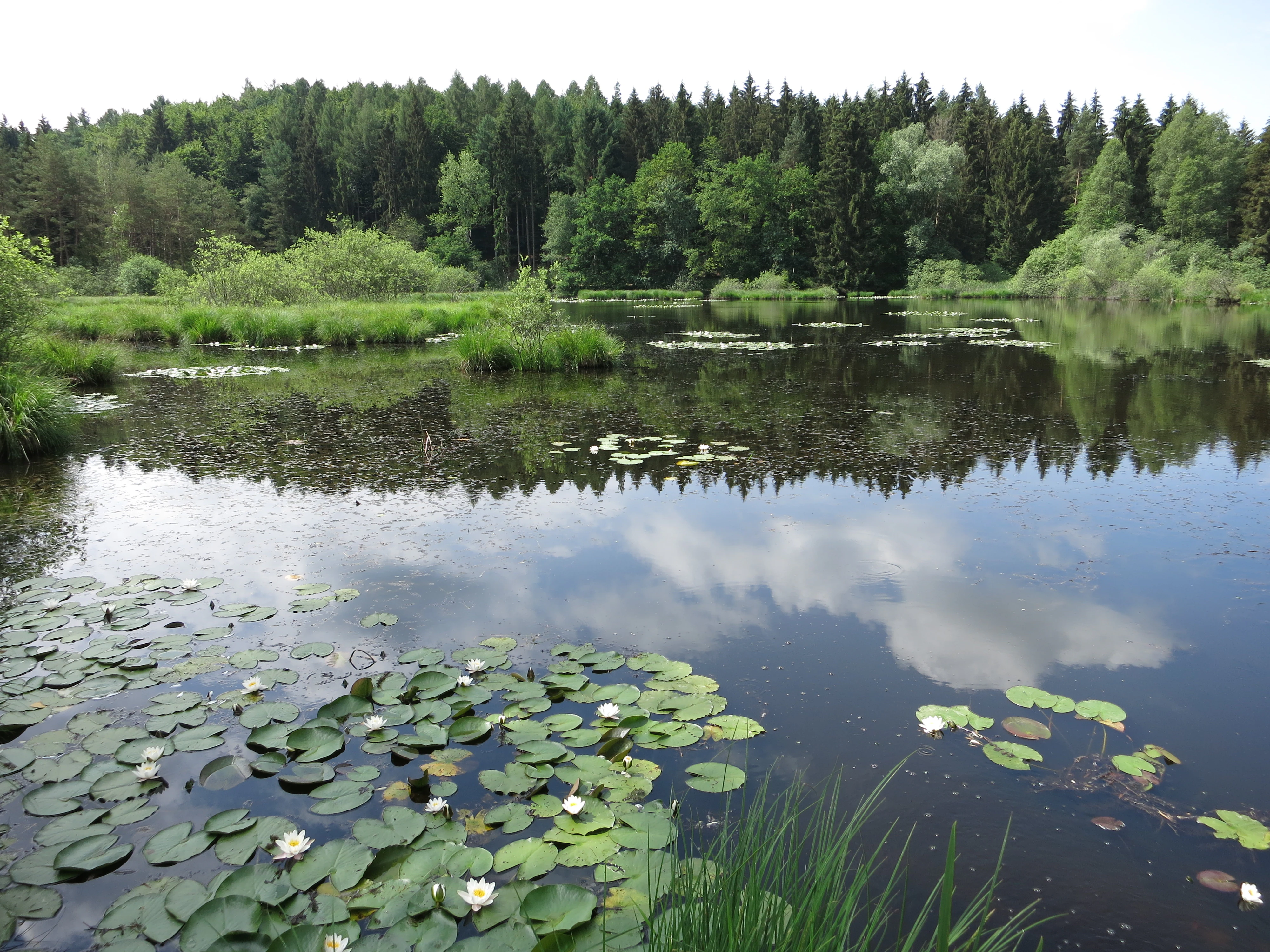
A peaceful pond with water lily pads and white blossoms on the surface, reflecting the sky and surrounding coniferous trees in the background.
A serene view of the Dingelsdorfer Ried nature reserve, featuring a calm pond dotted with water lilies and bordered by dense forest.

Bodanrück und westlicher Bodensee history and protected-area timeline

The Bodanrück und westlicher Bodensee protected area entered the European nature conservation framework through registration under the EU Flora-Fauna-Habitat Directive on 1 January 2005. A later regional council ordinance issued on 25 October 2018 formally defined the site as a Site of Community Importance.

Throughout the longer human history of the area, the shore and wetland zones of Lake Constance were intensively used in prehistory. The lake margins and adjoining wetlands preserve Pfahlbau, or pile-dwelling, sites of major archaeological significance, evidence that communities were living on stilts above shallow water near the peninsula for thousands of years.

Land use continued to shape the landscape through centuries of agriculture, grazing, and woodland management. Meadow and pasture traditions around broadleaf forest stands and along shoreline reedbeds created and maintain the very habitat mosaics, including species-rich wet meadows, dry limestone grasslands, and old-growth forest, that the modern FFH designation is designed to safeguard. Administrative responsibility for the site ultimately settled with the regional council at Tübingen, building continuity from the initial Freiburg-era designation.

Bodanrück und westlicher Bodensee landscape and geographic character

The defining physical character of Bodanrück und westlicher Bodensee is its glacial origin. The reserve sits across the Bodanrück peninsula and adjacent shoreline, where the Aller glacial period left a dense assemblage of ground moraine, drumlins, moraine ridges, and dead-ice holes (Toteislöcher).

Elevations rise from around 395 meters at lower lake-level ground up to about 693 meters at the highest ridges. The moraine topography produces a mosaic of gentle swells, steep ridges, deep hollows, and steich ponding, sometimes forming wetland-filled kettles. Caves appear in the calcareous and conglomerate rocks embedded in the glacial drift, while the springs along the slope produce calcium-rich tufa seepage.

Along the lake, the landscape shifts to a flat mosaic. Two lake basins bookend the site: the Überlinger See on the eastern flank and the Untersee on the western. Shallow bays, gently shelving shore platforms, reed fringes, and extended wet meadow gradients continue for kilometers. Dry slopes above lake level maintain open calcareous grasslands, dramatic cliffs, scree, and felsspaltenvegetation, allowing rock-dwelling plant communities to coexist beside lakeside marshes.
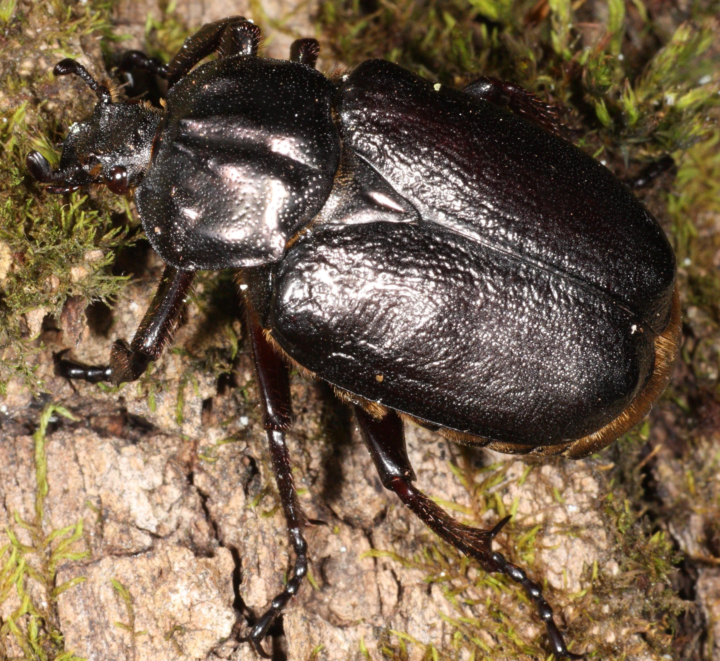
A close-up, high-angle shot of a shiny, dark-colored hermit beetle with a textured, rounded body standing on textured tree bark covered in patches of green moss.
A male hermit beetle, Osmoderma eremita, resting on mossy bark.

Bodanrück und westlicher Bodensee ecosystems, habitats, and plant life

The reserve protects one of the most habitat-diverse ecological packages in Baden-Württemberg. Habitat classes show that freshwater bodies, wet and mesophile grassland, and woodland together make up the core of the land use, while smaller proportions of mire, scrub, coniferous forest, and arable land round out the mix.

Forest communities are unusually diverse. Ravine and slope mixed forests, alluvial alder-ash-willow forests along streams, and other deciduous woodlands create forest micrhabitats with high vertical structure and old living trees needed for saproxylic beetles and woodland bats. Calcareous cliffs support a distinct community of Felsspalten vegetation, while tufa-forming petrifying springs generate a rare calcium carbonate fringe habitat.

Open habitats are equally prominent. Magerwiesen-like species-rich flatland hay meadows occupy a significant share of the protected grassland. Pioneer shoreline communities transition into sedge fens and reed fringes, both of which grade gradually into open water at the lake edge. These wetland-to-mowed-grassland transitions support specialist dragonflies, amphibians, marsh butterflies, and the rare mollusks associated with shoreline moss and detritus mats.

Bodanrück und westlicher Bodensee wildlife and species highlights

The protected site's most distinctive wildlife patterns are tied to its mosaic. Several Annex II species of the Habitats Directive depend specifically on the mix of old forest, nutrient-rich mires, and species-rich meadows here.

In standing and flowing waters, the bullhead (Cottus gobio) and the small stone crayfish (Austropotamobius torrentium) inhabit clean water systems and spring brooks. Wetland areas support marsh mollusks including Vertigo moulinsiana, Vertigo angustior, and the distinctive Anisus vorticulus snail. Dragonflies include the specialist Leucorrhinia pectoralis and Coenagrion mercuriale, both tied to intact marsh and shallow shoreline zones.

Old woodlands are home to the Bechstein's bat (Myotis bechsteinii) and the European beaver (Castor fiber), and to two iconic saproxylic beetles: the hermit beetle (Osmoderma eremita), also known as the Juchtenkäfer, and the stag beetle (Lucanus cervus). Calcareous wet meadows harbor butterfly species such as the dusky large blue (Maculinea nausithous), the scarce large blue (Phengaris teleius), and the marsh fritillary (Euphydryas aurinia). Amphibians include the yellow-bellied toad (Bombina variegata) and the northern crested newt (Triturus cristatus). Glacial lake margins historically supported and remain ecologically tied to one of the lake basin's most celebrated endemics, the Bodensee-Vergissmeinnicht (Myosotis rehsteineri).

Bodanrück und westlicher Bodensee conservation status and protection priorities

Bodanrück und westlicher Bodensee is not merely a high-density biodiversity reserve; it is the single largest Habitats Directive (FFH) site in Baden-Württemberg and therefore carries outsized weight within the state's Natura 2000 contribution. Its inclusion in the European network recognizes the area as essential for conserving habitat types and species at a transboundary level.

Conservation priority focuses on the persistence of habitat mosaics. Ravine and slope forests, tufa springs, alluvial forests, and natural nutrient-rich lakes are all habitat types for which the EU Habitats Directive specifically requires protection and management. The protection purpose explicitly cites maintaining drumlin-rich ground moraine, dead-ice landscapes, and shoreline wetland complexes, along with their transition into the Überlinger See and Untersee waters.

A defining conservation challenge here is the cultural character of the habitat. Calcareous dry grasslands, species-rich hay meadows, and ancient broadleaf woodland depend on traditional meadow cutting, grazing, and selective forest management rather than abandonment or intensification. The presence of prehistoric lake-dwelling sites also extends the site's cultural-heritage profile, while reinforcing the broader argument that historically used lake margins hold irreplaceable ecological and archaeological value simultaneously. The protected area's designated roles across ecological preservation, habitat protection, and wetland conservation make it a cornerstone site along the western Lake Constance basin.

Bodanrück und westlicher Bodensee cultural meaning and human context

The reserve encompasses an exceptionally layered cultural landscape. The Pfahlbau, or pile-dwelling, sites along the broader Lake Constance shorelines represent some of the most significant prehistoric lakeside settlements in the Alpine arc and have contributed to international recognition of such sites as evidence of early lake-based communities.

Traditional land use made and still maintains the ecological richness of the area. Centuries of meadow cultivation, hillside grazing, woodland coppicing, and shoreline management have produced the very conditions under which dry limestone grasslands, wet meadows, fens, and old-growth forests persist. Communities such as those on the peninsula and the surrounding lake margins have long balanced farming, fishing, and water-level-specific land use.

Local identity along the Bodanrück remains tied to the lake and the agricultural rhythms of the peninsula. The bordering municipalities of Allensbach, Bodman-Ludwigshafen, Konstanz, Radolfzell am Bodensee, and Reichenau each contribute portions of the protected area, suggesting that the reserve is woven into everyday regional life and not treated as a remote wilderness.

Top sights and standout views in Bodanrück und westlicher Bodensee

Among the most distinctive features of Bodanrück und westlicher Bodensee are the prevalence of glacial landforms (drumlins, moraines, dead-ice lakes) within an FFH protected area of more than 14,000 hectares, its position as the largest Habitats Directive (FFH) site in Baden-Württemberg, and its remarkable integration of limestone cliff, karst seepage, and shoreline wetland habitats within a single protected area.

Also notable is the concentration of protected species-rich habitats: tufa-forming springs, calcareous Felsspaltenvegetation habitats, alluvial alder-ash-willow forests, and magerwiesen-like flatland hay meadows, each representing habitat types specifically protected under EU law. The coincidence of prehistoric pile-dwelling landscapes with a working modern landscape adds a rare archaeological layer to the conservation narrative.

Best time to visit Bodanrück und westlicher Bodensee

Spring and early summer tend to bring out the character of the reserve's meadows and wetlands, when hay meadows begin flowering and shallow shoreline marshes along the Überlinger See and Untersee are at their most biologically active. Late spring is also a peak period for dragonflies, marsh butterflies, and amphibian activity around fens and pond-wetland margins.

Late summer and early autumn can be appealing for visitors more interested in forested terrain: deciduous and mixed woodlands on the moraine ridges are quieter, the climate along the lake is generally temperate, and bat activity picks up in warmer twilight hours. The lake-edge wetlands remain scenic through the warmer months, even when access is mainly along the perimeter, and late spring meltwater patterns can leave wet meadows and kettle mires distinctively colorful against the evergreen of the surrounding conifer proportion of the landscape.

Monthly climate preview

Long-term representative temperature and precipitation averages recorded across twelve monthly cycles

Bodanrück und westl. Bodensee Climate Normals and Annual Temperature Patterns

Historical measurements from the representative coordinate track average monthly temperatures ranging from sub-zero winter minimums to warm summer maximums alongside varying daily precipitation rates. Analyzing the complete twelve-month sequence reveals detailed meteorological shifts across the protected landscape.
Annual mean8 °C
-1 °C18 °C
Jan-1°
Feb-1°
Mar
Apr
May12°
Jun16°
Jul18°
Aug18°
Sep13°
Oct
Nov
Dec
Warmest month
July

17.9 °C

Coolest month
January

-1.3 °C

Wettest month
June

5.1 mm/day

Driest month
February

2.8 mm/day

Park location guide

Geography guide, regional context, and park location map for Bodanrück und westlicher Bodensee

Bodanrück und westlicher Bodensee park geography, regions, and map view in Germany

Understand where Bodanrück und westlicher Bodensee sits in Germany through a broader geographic reading of the surrounding landscape, nearby location context, and its mapped position within the national park landscape.

How Bodanrück und westlicher Bodensee fits into Germany

Germany is a federal republic in Western and Central Europe with a population of over 83 million across sixteen constituent states. It is Europe's largest economy by nominal GDP and a major global exporter and importer. The capital is Berlin, and the country borders Denmark, Poland, Czech Republic, Austria, Switzerland, France, Luxembourg, Belgium, and the Netherlands.

Wider geography shaping Bodanrück und westlicher Bodensee in Germany

Germany is located in Western and Central Europe, spanning 357,022 km². It borders Denmark to the north, Poland and the Czech Republic to the east, Austria and Switzerland to the south, and France, Luxembourg, Belgium, and the Netherlands to the west. The country has coastlines on the Baltic Sea and North Sea to the north, with the Alps located in the southern region.

Map view of Bodanrück und westlicher Bodensee

Use this park location map to pinpoint Bodanrück und westlicher Bodensee in Germany, understand its exact geographic position, and read its mapped placement within the surrounding landscape more clearly.

Pigeon | © OpenStreetMap contributors

Location context for Bodanrück und westlicher Bodensee

Baden-Württemberg
Recorded earthquake history

Browse the Bodanrück und westl. Bodensee Historical Earthquake Catalogue

Explore documented seismic events associated with the glacial terrain of Bodanrück und westl. Bodensee. Access a structured record of historical earthquakes, including magnitudes and location data, through the MoriAtlas seismic discovery tool.

Bodanrück und westl. Bodensee Earthquake History

Catalogued events

68 events

Strongest magnitude

Magnitude 5.2

Most recent event

Jul 20, 2013

This history includes earthquakes recorded inside the park or within 50 km of its borders

Visualizing glacial terrain, lake shorelines, and diverse protected habitats

Bodanrück und westl. Bodensee Photos and Protected Landscape Scenery

Photographic documentation reveals the intricate glacial moraines, kettle holes, and wetland fringes that define the Bodanrück peninsula and Lake Constance shoreline. Examining these protected habitats clarifies the complex interplay between open water, calcareous dry grasslands, and ancient woodland terrain.

A peaceful pond with water lily pads and white blossoms on the surface, reflecting the sky and surrounding coniferous trees in the background.

A close-up, top-down view of a Lake Constance forget-me-not plant with small blue flowers and yellow centers, growing among grey river stones.

A close-up, high-angle shot of a shiny, dark-colored hermit beetle with a textured, rounded body standing on textured tree bark covered in patches of green moss.

Park atlas

Compare adjacent glacial terrains, shoreline wetlands, and regional conservation areas.

Parks Near Bodanrück und westl. Bodensee and Surrounding Protected Landscapes

Browsing other protected areas near Bodanrück und westl. Bodensee reveals how regional ice age topography and lakeside habitats extend across neighboring terrain. Comparing connected conservation zones provides a deeper understanding of the broader geography shaping the surrounding region.
A horizontal watercolor painting depicting a soft-focus valley scene with rolling hills, scattered green trees, and a light sky.
Nature reserveBaden-Württemberg
11 km away#1 closest

Northeast

Deggenhauser Tal Nature Reserve: Mapped Geography and Protected Valley Landscapes

Glacial terrain and watershed ridges in Baden-Württemberg

Investigate the protected geography of Deggenhauser Tal, an expansive nature reserve in the Oberschwäbisches Hügelland. This record maps the complex network of stream corridors, steep valley slopes, and ridge heights that define this Natura 2000 protected area. Gain insights into the glacial relief and varied land use patterns that characterize this essential southwestern German valley ecosystem.

Area
8.492 km²
Established
2019
Protected landscapeBaden-Württemberg
About 12 km away#2 closest

East

Württembergisches Bodenseeufer, Neufassung Teilbereich Friedrichshafen-West Protected Landscape

Mapped greenbelt corridor along the Lake Constance shoreline in Baden-Württemberg.

This protected landscape encompasses a vital 114-hectare corridor of lakeshore habitats and cultural land near Friedrichshafen. It preserves a critical mix of reed beds, shallow-water zones, and riparian woodland galleries that maintain the near-natural state of the Württemberg lakeshore. The area serves as a significant ecological bridge between the waters of Lake Constance and the urbanised inland terrain of the surrounding Bodenseekreis district.

Area
1.14 km²
Established
2004
Relief
Lowland
Scope
Mixed
Protected landscapeBaden-Württemberg
About 20 km away#3 closest

Northwest

Hegau Protected Landscape in Baden-Württemberg: Atlas and Geographic Regional Map

Plateau landscape and agricultural heritage in Tuttlingen

The Hegau protected landscape in the Landkreis Tuttlingen preserves a characteristic segment of the Hegaualb plateau. Defined by undulating farmland, meadows, and the isolated Franzengrund woodland, this reserve offers a clear look at the rural geography and cultural landscape patterns typical of this part of southwestern Germany.

Area
2.723 km²
Established
1952
IUCN
V
Relief
Upland
A flat, stylized illustration showing a waterfall cascading from a cliff into a river that flows alongside a forest towards a large body of water under a soft-toned sky.
Protected landscapeBaden-Württemberg
About 22 km away#4 closest

East

Württembergisches Bodenseeufer: Protected Shoreline Landscapes of Lake Constance

A regional atlas of riparian habitats in Baden-Württemberg

Württembergisches Bodenseeufer preserves over 180 hectares of natural shoreline across Friedrichshafen, Langenargen, and Kressbronn am Bodensee. This protected landscape highlights essential riparian ecology, featuring diverse river mouth environments and largely unaltered forest edges that define the southern borders of the Bodenseekreis district.

Area
1.88 km²
Established
1940
Relief
Lowland
Climate
Temperate
Watercolor painting depicting a gentle hill with forest cover and a winding river in the foreground, using soft pastel tones.
Protected landscapeLandkreis Tuttlingen
About 23 km away#5 closest

Northwest

Honberg Protected Landscape: Geological Atlas and Mapped Terrain in Landkreis Tuttlingen

A preserved Danube Umlaufberg and historical cultural landmark.

The Honberg represents a rare example of a protected landscape fully integrated within an urban setting in southwestern Germany. Defined by its origin as a Danube river meander, the ridge showcases layered limestone formations, diverse meadow habitats, and ancient fortification sites that remain shielded from regional development. This site is essential for understanding the local topography of the Swabian Alb and the historical land-use patterns within the Danube valley.

Area
0.598 km²
Established
1986
IUCN
V
Protected landscapeBaden-Württemberg
About 24 km away#6 closest

Northeast

Pfrunger Ried, Rinkenburg Protected Landscape: Geographic and Terrain Analysis

Moorland and molasse hill system in Baden-Württemberg

Covering roughly 762 hectares in the Ravensburg district, Pfrunger Ried, Rinkenburg is a significant protected landscape known for its glacial tongue basin and peat-forming wetlands. This entry explores the interplay between the wetland systems and the prominent Tertiary molasse hill that define this distinct upper Swabian natural area.

Area
7.62 km²
Established
1967
Relief
Upland
Scope
Terrestrial
Protected landscapeBaden-Württemberg
About 26 km away#7 closest

East

Tettnanger Wald mit Hochwacht, Krüntenbühl, Reichenbühl, Argenhardter Kopf, Schoos und Steilrand des Argentales an dem Schwandenbogen: Geography and Protected Boundaries

A Glacial Landscape Protection Area in the Lake Constance Basin

This protected landscape in Baden-Württemberg captures a classic moraine terrain shaped by glacial retreat. With its system of ridges, dead-ice hollows, and escarpments along the Argen valley, the area serves as a critical geological reference point. Explore the detailed topography and mapped boundaries of this forest landscape within the broader Bodenseebecken region.

Area
7.01 km²
Established
1954
Protected landscapeBaden-Württemberg
About 26 km away#8 closest

East

Steilrand und Schotterfeld des Argentals südlich der Kochermühle Protected Landscape Atlas

Glacial geomorphology and river terrace geography in Baden-Württemberg

This protected area provides a diagrammatic view of the Argen valley's ice-age origins. By preserving a Late Glacial terrace complete with its characteristic steep edge and gravel-strewn surfaces, it offers an essential geographic reference for understanding the retreat of the Würm ice within the wider Bodenseebecken region.

Area
0.081 km²
Established
1954
Relief
Lowland
Climate
Temperate

Common questions about visiting, size, designation, and location context for Bodanrück und westlicher Bodensee

Bodanrück und westlicher Bodensee FAQs for park facts, access, geography, and protected area context

Find quick answers about Bodanrück und westlicher Bodensee, including protected-area facts, park geography, trail and visitor context, and how the park fits into its surrounding country and regional landscape.
MoriAtlas Explorer

Continue Your Protected Areas Search Across the Global Atlas

Deepen your exploration by continuing the structured search for national parks and protected areas worldwide. Utilize the comprehensive filtering capabilities to compare different conservation landscapes and refine your understanding of global park geography. Discover more about the distribution and characteristics of protected natural areas.

Global natural geography