Mori Atlas logo
Nature reserveBodenstein

Exploring the limestone escarpment and hillside topography of the Eichsfeld region

Bodenstein Nature Reserve: Mapped Protected Landscapes and Geological Terrain in Thuringia

(Naturschutzgebiet Bodenstein)

Bodenstein serves as a significant protected nature reserve situated along the western scarp edge of the Ohmgebirgsplateau in Thuringia, Germany. The area displays a complex mosaic of terrain defined by steep slopes, fragmented hilltops, and exposed Muschelkalk limestone cliffs. This geographic setting, shaped by historical rockfalls and spring-fed ravine systems, provides an essential look at the protected land structures and forested habitats characteristic of the central German highlands.

nature reserveMuschelkalk cliffOhmgebirgsplateauEichsfeldThuringialimestone escarpment

Bodenstein

Nature reserve

Park overview

Structured park overview, official facts, and landscape profile for Bodenstein Nature Reserve

Bodenstein Nature Reserve park facts, protected area profile, and essential visitor context

Review the core facts for Bodenstein Nature Reserve, including designation, size, terrain, visitor scale, habitats, and operating context in one park-focused overview.

About Bodenstein Nature Reserve

Bodenstein is a compact but ecologically rich nature reserve in northern Thuringia, positioned along the dramatic steep slope that marks the western boundary of the Ohmgebirgsplateau. The protected area extends north of the village of Wintzingerode, with the small locality of Bodenstein itself sitting at the foot of the hills. The reserve is dominated by forest and a sequence of individually named hilltops that give the area a varied microtopography unusual for a reserve of only 133.5 hectares.

The defining physical feature of Bodenstein is geologically driven. The higher elevations of the plateau edge are formed from Lower Muschelkalk limestone, while the valleys beneath them have been cut into the softer Upper Buntsandstein (Röt) strata. Where this softer material erodes, large blocks of the overlying Muschelkalk have periodically collapsed downslope, producing natural rockfalls and leaving craggy limestone exposures embedded within what would otherwise be a closed forest slope. This combination of bedrock types explains much of the area's ecological variety, supporting different communities on warm, dry limestone outcrops, on scree and rubble slopes, and in the cooler, moister valley bottoms fed by small springs.

The reserve is administratively tied to the Land of Thuringia and has been continuously protected since 1961. It forms one of several nature reserves in the Eichsfeld district and is a documented reference site for mosses and other vegetation studies in the region. The adjacent Burg Bodenstein castle, while not legally part of the protected area, is closely associated with the landscape and contributes to the cultural setting of the site.

Quick facts and research context for Bodenstein Nature Reserve

Bodenstein is an IUCN Category IV habitat and species management area, administratively recorded as NSG number 006 in Thuringia and listed in the World Database on Protected Areas under WDPA ID 14481. The site covers roughly 133.5 hectares and was formally placed under protection in 1961. It lies in the Landkreis Eichsfeld, north of Wintzingerode (a part of Leinefelde-Worbis), at approximately 51.46 degrees north and 10.34 degrees east. The reserve is dominated by wooded steep slopes and isolated hill summits formed from Muschelkalk limestone.

Protection and recognition

Examine documented terrestrial protection metrics and established designation timelines for Bodenstein.

Bodenstein Protection Status, Designation History, and Official Records

Bodenstein maintains official terrestrial protection status established in 1961, documented across standard global conservation databases. Verified records outline the baseline designation history and management framework associated with this protected area.

Protection details

Protection scope
Terrestrial
Designated year
1961
Transboundary protection
No
WDPA ID
14481
Park context

Deeper park guide and search-rich context for Bodenstein Nature Reserve

Bodenstein Nature Reserve history, landscape, wildlife, and travel context

Explore Bodenstein Nature Reserve through its history, landscape character, ecosystems, wildlife, conservation priorities, cultural context, and seasonal travel timing in a structured park guide built for atlas discovery and search intent.

Why Bodenstein Nature Reserve stands out

The reserve is best known for its fragmented Muschelkalk cliff-edge landscape along the western face of the Ohmgebirgsplateau, where a series of individual hilltops (Mittelberg, Großer Kranzberg, Kleiner Kranzberg, and Schlossberg) rise above deeply incised side valleys. It is also recognized for its geological character, where ancient landslides and rockfalls have left exposed limestone cliffs interleaved with Röt valley floors. The mix of warm limestone substrates, shaded ravines, and spring-fed brooks creates a distinctive habitat mosaic within a relatively small protected area.
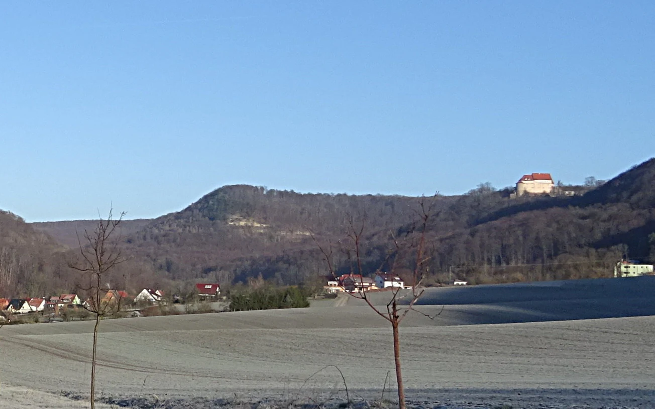
A landscape view showing rolling forested hills under a clear blue sky, with a small village nestled at the base and a prominent light-colored castle situated on the ridge.
Forested slopes of the Ohmgebirge mountains near Wintzingerode, with Schloss Bodenstein visible on the hillside.

Bodenstein Nature Reserve history and protected-area timeline

Bodenstein was formally placed under nature protection in 1961 and is registered as NSG number 006 in Thuringia's system of protected areas. The reserve has since been catalogued internationally under World Database on Protected Areas entry 14481 and is classified as an IUCN Category IV habitat and species management area. Beyond the establishment date and successive botanical studies, no further administrative milestones can be reliably reconstructed from the available source material. Scholarly attention to the site has continued over recent decades, including a 1999 expert report evaluating the reserve's conservation value and outlining management measures, as well as published bryological and vegetation studies documenting its flora.

Bodenstein Nature Reserve landscape and geographic character

The landscape of Bodenstein is defined by a steep escarpment edge separating the flat-ish Ohmgebirgsplateau from the lower terrain near Wintzingerode. This scarp has been dissected by several side valleys, breaking the slope into a chain of separate summits: the Mittelberg at roughly 485 meters, the Großer Kranzberg at 481.1 meters, the Kleiner Kranzberg at about 460 meters, and the Schlossberg at 465.2 meters, which carries the historic Burg Bodenstein but is no longer part of the reserve itself.

Below this ridge of hills lies the Silbergrund, a valley into which several small springs from the side ravines discharge and which is drained by the Silbergrundgraben, a brook flowing into the Katharine. The valley floors and the lower hillside consist largely of Upper Buntsandstein (Röt), a softer red sedimentary layer that has been repeatedly disturbed by erosion and historical landslides. Where Muschelkalk blocks have broken away from the cliff above, they now lie scattered across the slopes, and a number of older rockfalls have left exposed limestone cliffs visible within the woodland.

Bodenstein Nature Reserve ecosystems, habitats, and plant life

Bodenstein's ecological character is closely tied to its geology. The reserve includes a mix of forested hilltops, rocky cliff faces, scree slopes, and shaded spring valleys, all within a relatively compact footprint. The warm, dry microclimate of the Muschelkalk outcrops contrasts strongly with the cooler and damper conditions in the Röt-bottomed side valleys fed by small springs, producing a habitat mosaic that supports varied plant communities.

Mosses and other small vegetation of the reserve have been specifically studied in regional literature, and at least one dedicated publication has catalogued the bryophyte assemblages and bryophyte communities of the area. Broader vegetation surveys have also been conducted, treating Bodenstein and the adjacent Schlossberg area together as a coherent ecological unit along the Ohmgebirge edge. While the source material does not enumerate mammalian, avian, or insect fauna in detail, the structural complexity of the habitat mosaic clearly supports a diversified forest-floor community typical for limestone escarpments in central Germany.

Bodenstein Nature Reserve wildlife and species highlights

The available source material does not provide a specific inventory of mammal, bird, reptile, or invertebrate species recorded inside the reserve, so no detailed wildlife profile can be reliably reconstructed from the sources provided. Bodenstein is best understood ecologically as a complex mosaic of cliff, scree, forest, and spring-valley habitats, and the visible image caption within the source confirms the reserve's identity as a wooded mountainside dominated by the Großer Kranzberg and the Schlossberg rather than as an open wildlife-viewing destination.

Bodenstein Nature Reserve conservation status and protection priorities

Bodenstein has been legally protected since 1961 as one of the older nature reserves in Thuringia, classified as an IUCN Category IV habitat and species management area. Its primary conservation value lies in preserving the Muschelkalk cliff landscape and associated forest mosaic along the western edge of the Ohmgebirgsplateau, including the springs and brooks that feed the Silbergrund. The site has also been the focus of specific ecological surveys, including a 1999 protection-worthiness expert report with management recommendations and dedicated moss and vegetation studies. These documents underline its role as a reference site for understanding limestone scarp habitats within the Eichsfeld district.

Bodenstein Nature Reserve cultural meaning and human context

The most prominent cultural landmark associated with Bodenstein is the historic Burg Bodenstein castle, located on the Schlossberg above the reserve. Although the castle's built footprint lies outside the legal boundaries of the nature reserve, it sits directly atop one of the defining summits of the protected landscape and shapes how the area is perceived. The reserve itself takes its name from the nearby small locality of Bodenstein, part of the town of Leinefelde-Worbis, and the broader Eichsfeld region has a long-standing identity as a historically Catholic, rural landscape in northern Thuringia.

Top sights and standout views in Bodenstein Nature Reserve

The reserve's strongest points of distinction are its compact but well-defined Muschelkalk cliff-edge landscape, the chain of four individually named hilltops along the Ohmgebirgsplateau scarp, and the presence of exposed limestone outcrops created by historical rockfalls. Its hydrology is also distinctive within the Eichsfeld district: a network of small springs in the side valleys feeds the Silbergrundgraben and ultimately the Katharine. Bodenstein's combination of long-established protection, geological complexity, and documented bryological interest makes it a notable local reference site for habitat and species management.

Best time to visit Bodenstein Nature Reserve

The source material does not provide seasonal access guidance, so specific month-by-month visitor timing cannot be supported. Generally for a forested Muschelkalk escarpment in central Germany, spring through early autumn is the most useful period for experiencing the woodland, springs, and cliff exposures on foot, while winter access may be limited by weather and steep, snow-prone slopes. Any visitor planning a trip should consult current local information for trail and access conditions rather than relying on generic seasonal advice.

Monthly climate preview

Long-term temperature and precipitation patterns across measured coordinates

Bodenstein Climate Normals and Representative Monthly Temperature Rhythms

Bodenstein exhibits a recorded annual temperature span alongside consistent daily precipitation averages across sampled coordinates in Thuringia. Examining the complete monthly climate record reveals detailed variations in temperature and moisture distribution throughout the year.
Annual mean8 °C
-1 °C18 °C
Jan-1°
Feb-1°
Mar
Apr
May12°
Jun15°
Jul18°
Aug18°
Sep13°
Oct
Nov
Dec
Warmest month
July

17.7 °C

Coolest month
January

-1.4 °C

Wettest month
July

2.8 mm/day

Driest month
April

1.5 mm/day

Park location guide

Geography guide, regional context, and park location map for Bodenstein Nature Reserve

Bodenstein Nature Reserve park geography, regions, and map view in Germany

Understand where Bodenstein Nature Reserve sits in Germany through a broader geographic reading of the surrounding landscape, nearby location context, and its mapped position within the national park landscape.

How Bodenstein Nature Reserve fits into Germany

Germany is a federal republic in Western and Central Europe with a population of over 83 million across sixteen constituent states. It is Europe's largest economy by nominal GDP and a major global exporter and importer. The capital is Berlin, and the country borders Denmark, Poland, Czech Republic, Austria, Switzerland, France, Luxembourg, Belgium, and the Netherlands.

Wider geography shaping Bodenstein Nature Reserve in Germany

Germany is located in Western and Central Europe, spanning 357,022 km². It borders Denmark to the north, Poland and the Czech Republic to the east, Austria and Switzerland to the south, and France, Luxembourg, Belgium, and the Netherlands to the west. The country has coastlines on the Baltic Sea and North Sea to the north, with the Alps located in the southern region.

Map view of Bodenstein Nature Reserve

Use this park location map to pinpoint Bodenstein Nature Reserve in Germany, understand its exact geographic position, and read its mapped placement within the surrounding landscape more clearly.

Pigeon | © OpenStreetMap contributors

Location context for Bodenstein Nature Reserve

Thuringia

Explore visual records of the steep Ohmgebirgsplateau scarp, limestone outcrops, and valley habitats.

Bodenstein Photos and Scenery: Visualizing Limestone Escarpments and Forested Slopes

Examine detailed Bodenstein photos to understand the rugged terrain, limestone cliffs, and mixed forest habitats defining the protected nature reserve. Visual reference imagery reveals the steep escarpment edge and complex geological character shaped across the Eichsfeld landscape.

A landscape view showing rolling forested hills under a clear blue sky, with a small village nestled at the base and a prominent light-colored castle situated on the ridge.

Park atlas

Compare regional nature reserves and connected limestone escarpment terrain

Exploring Parks Near Bodenstein and Surrounding Protected Landscapes

Continue exploring protected areas near Bodenstein to examine adjacent forested ridges and limestone escarpment terrain. Comparing regional nature reserves provides a broader geographic context for central German habitat types.
A horizontal watercolor painting depicting a soft, rolling landscape with green meadows, patches of forest, and distant hills under a light sky.
Nature reserveLandkreis Eichsfeld
About 4.3 km away#1 closest

Northwest

Grenzstreifen zwischen Teistungen und Ecklingerode Protected Nature Reserve Mapping

Conservation corridor within the Landkreis Eichsfeld regional geography.

Located in the Eichsfeld district of Thuringia, the Grenzstreifen zwischen Teistungen und Ecklingerode nature reserve functions as a vital segment of the trans-European Green Belt. This protected area showcases an elongated, structural diversity of beech forest ecosystems and meadowlands shaped by natural succession. Review the mapped boundaries and topographical characteristics of this significant corridor that bridges modern forestry and historical conservation.

Area
1.477 km²
Established
2000
IUCN
IV
Relief
Upland
A soft watercolor illustration depicting layered green and pale pink rolling hills under a light sky.
Protected areaThuringia
About 10 km away#2 closest

East

Bleicheröder Berge: Geographic Profile and Protected Landscape Context in Thuringia

Mapping the forested ridges and Muschelkalk geology of the Thuringian region.

Investigate the Bleicheröder Berge as a vital protected area in Thuringia. This resource outlines the range's formation as a series of isolated hill remnants, its fossil-bearing limestone cliffs, and the botanical diversity characterizing its beech forests and rare orchid populations.

Area
16 km²
Relief
Mountain
Climate
Temperate
Access
Easy access
Nature reserveThuringia
About 16 km away#3 closest

Northeast

Sülzensee, Mackenröder Wald: A Detailed Look at Thuringia's Protected Nature Reserve

Exploring the beech forest landscapes and stream-carved terrain of northern Thuringia.

Sülzensee, Mackenröder Wald is a protected nature reserve in northern Thuringia known for its expansive beech forests and diverse geological foundation. Spanning over 280 hectares, the area features undulating ridges, deep-cut stream valleys, and a unique position atop the Elbe-Weser watershed. This geography-focused overview details the reserve's status as a corridor for wildlife and its significant role in regional habitat conservation.

Area
2.802 km²
Established
2000
IUCN
IV
A horizontal watercolor painting showing rolling green and yellow hills with distant purple-toned forests against a white background.
Nature reserveThuringia
About 17 km away#4 closest

Southeast

Keulaer Wald Nature Reserve: Geographic Overview of the Dün Plateau Forest in Thuringia

Mapped beech-dominated plenterwald and limestone escarpment terrain

Located in northern Thuringia, Keulaer Wald is a designated nature reserve characterized by its continuous beech canopy on shell limestone bedrock. This site serves as a vital protected area within the regional forest belt, offering high-elevation viewpoints over the surrounding Eichsfeld Basin and the distant Harz mountain range.

Area
2.97 km²
Established
1961
Relief
Mountain
Climate
Temperate
Nature reserveLower Saxony
About 19 km away#5 closest

North

Steinberg bei Scharzfeld Nature Reserve: Dolomite Geology and Harz Foothill Geography

A detailed protected-area profile of the dolomite ridge in Lower Saxony.

Steinberg bei Scharzfeld is a protected nature reserve in the southern Harz region, defined by its rare dolomite geology and rugged cliff habitats. This site features exposed rock outcrops, drought-prone calcareous grasslands, and the natural Steinkirche cave monument. It serves as a vital anchor for understanding the ecological diversity of the local karst landscape and its distinct geological character compared to the surrounding mountain environments.

Area
0.14 km²
Established
1988
Relief
Upland
Climate
Temperate
Watercolor painting of green rolling hills, forested slopes, and light-colored rocky outcrops in a rural landscape.
Nature reserveThuringia
About 20 km away#6 closest

Southwest

Ibenkuppe Nature Reserve and the Muschelkalk Cuesta Landscapes of Thuringia

Mapped protected woodland and limestone escarpment geography

Located in the Eichsfeld district, Ibenkuppe is a nature reserve that protects a significant Muschelkalk spur. Its geography includes the prominent Abrißwand landslide scar and the deeply cut Rosoppe valley. This site provides a focused look at the intersection of forested limestone slopes and traditional valley pasture fragments in the heart of Germany.

Area
0.292 km²
Established
1997
Relief
Mountain
Scope
Terrestrial
A soft watercolor painting of a meadow landscape, featuring a dirt path winding through wildflowers toward green trees with rolling hills in the background.
Nature reserveThuringia
About 20 km away#7 closest

South

Kühmstedter Berg Nature Reserve: A Protected Landscape and Archaeological Site in Thuringia

Examining forest ecology and medieval earthworks on a central German ridge

Kühmstedter Berg stands as a protected nature reserve in Thuringia, characterized by its Muschelkalk geology and established beech-rich oak and hornbeam woodland. This site maps a critical intersection of natural forest habitat and historical land use, featuring visible remnants of a Bronze Age tumulus cemetery and the defensive lines of the medieval Mühlhäuser Landgraben.

Area
0.387 km²
Established
1961
Relief
Upland
Scope
Terrestrial
Watercolor painting of a rolling forested ridge under a pale sky.
Nature reserveThuringia
About 22 km away#8 closest

Southwest

Lengenberg Nature Reserve: A Geographical Overview of the Eichsfeld Ridge

Protected beech and yew woodlands in Thuringia, Germany

The Lengenberg Nature Reserve forms a prominent, fully forested ridge within the Eichsfeld region of Thuringia. Renowned for hosting one of the most substantial yew populations in central Europe, the reserve showcases a geological transition between shell limestone and red sandstone. This mapping of the terrain provides insight into the ecological structure of the Eichsfeld-Hainich-Werratal area.

Area
0.26 km²
Established
1961
Relief
Mountain
Climate
Temperate

Common questions about visiting, size, designation, and location context for Bodenstein Nature Reserve

Bodenstein Nature Reserve FAQs for park facts, access, geography, and protected area context

Find quick answers about Bodenstein Nature Reserve, including protected-area facts, park geography, trail and visitor context, and how the park fits into its surrounding country and regional landscape.
MoriAtlas Explorer

Continue Your Protected Areas Search Across the Global Atlas

Deepen your exploration by continuing the structured search for national parks and protected areas worldwide. Utilize the comprehensive filtering capabilities to compare different conservation landscapes and refine your understanding of global park geography. Discover more about the distribution and characteristics of protected natural areas.

Global natural geography