
Mori Atlas logo
Wildlife reserveBoot Island National Wildlife Area

Examining the island geography and intertidal wetland ecosystems of the Bay of Fundy

Boot Island National Wildlife Area: A Protected Coastal Sanctuary in Nova Scotia

Boot Island National Wildlife Area stands as a protected coastal sanctuary located within the Southern Bight of the Minas Basin in Nova Scotia. This island reserve functions as a critical refuge for waterfowl and shorebirds, reflecting the dynamic influence of the extreme tides and salt marshes characteristic of the Bay of Fundy. The reserve provides essential undisturbed habitat within an internationally recognized estuarine environment, showcasing the importance of focused coastal conservation.

national wildlife areaisland reservecoastal habitatsalt marshintertidal mudflatswaterfowl
A stylized vector-style illustration of a coastal landscape with green shrubs in the foreground, a sandy beach, and a distant shoreline under a soft yellow sun.

Boot Island National Wildlife Area

Wildlife reserve

Park overview

Structured park overview, official facts, and landscape profile for Boot Island National Wildlife Area

Boot Island National Wildlife Area park facts, protected area profile, and essential visitor context

Review the core facts for Boot Island National Wildlife Area, including designation, size, terrain, visitor scale, habitats, and operating context in one park-focused overview.

About Boot Island National Wildlife Area

Boot Island National Wildlife Area is a compact federal wildlife reserve situated on a small island in the Southern Bight of the Minas Basin, in Kings County, Nova Scotia. The reserve covers 107 hectares of coastal terrain that exemplifies the salt-influenced, tide-shaped environment characteristic of the inner Bay of Fundy. Though modest in size, the area plays an important role in Canada's national system of wildlife reserves by safeguarding habitat for birds and other coastal wildlife in one of the most ecologically dynamic estuarine regions on the Atlantic coast.

Administratively, the reserve is managed by the Canadian Wildlife Service, the federal agency responsible for protecting and conserving migratory birds and their habitats across Canada. Founded in 1979, Boot Island was designated to preserve a representative portion of the shoreline and near-shore habitat that supports waterfowl during migration, as well as shorebirds that depend on the mudflats and marshes of the Minas Basin. The reserve's IUCN Category Ia designation reflects its status as a strictly protected area where ecological values take precedence over other uses.

The island sits within the broader Southern Bight-Minas Basin wetland complex, which was recognized as a Ramsar site in 1987 under the Convention on Wetlands of International Importance. This international designation highlights the significance of the surrounding tidal flats, salt marshes, and estuarine waters as habitat for migratory waterfowl and shorebirds traveling along the Atlantic Flyway. Boot Island functions as a protected node within this larger recognized wetland system, contributing to the connectivity and quality of habitat across the basin.

Although the reserve does not serve as a public recreation destination, its ecological importance endures. Protection of the island helps maintain breeding, roosting, and staging habitat free from the pressures that affect nearby mainland coastlines, while preserving the natural processes that define the Bay of Fundy ecosystem.

Quick facts and research context for Boot Island National Wildlife Area

Boot Island National Wildlife Area is a 107 hectare federal wildlife reserve in Kings County, Nova Scotia, situated in the Southern Bight of the Minas Basin along the Bay of Fundy. Created in 1979, it is administered by Environment and Climate Change Canada through the Canadian Wildlife Service and is classified as a strict nature reserve (IUCN Category Ia). The island forms part of the larger Southern Bight-Minas Basin Ramsar site, designated in 1987, which highlights the area's international importance for wetland conservation and migratory birds.

Protection and recognition

Examine the terrestrial protection scope, 1987 establishment year, and official status records.

Boot Island National Wildlife Area Protection Status and Designation History

Boot Island National Wildlife Area holds documented terrestrial protection status established in 1987 under verified geographic frameworks. Reference records outline the designation timeline and management scope without additional international recognition listings.

Protection details

Protection scope
Terrestrial
Designated year
1987
Transboundary protection
No
WDPA ID
18164
Park context

Deeper park guide and search-rich context for Boot Island National Wildlife Area

Boot Island National Wildlife Area history, landscape, wildlife, and travel context

Explore Boot Island National Wildlife Area through its history, landscape character, ecosystems, wildlife, conservation priorities, cultural context, and seasonal travel timing in a structured park guide built for atlas discovery and search intent.

Why Boot Island National Wildlife Area stands out

Boot Island National Wildlife Area is best known for its role in protecting coastal habitats that support concentrations of waterfowl and shorebirds within the Minas Basin. Its placement within a Ramsar-designated wetland system, combined with the dynamic intertidal environment of the Bay of Fundy, gives the reserve a strong identity as a refuge for migratory and coastal birdlife along one of North America's most ecologically significant estuarine coastlines.
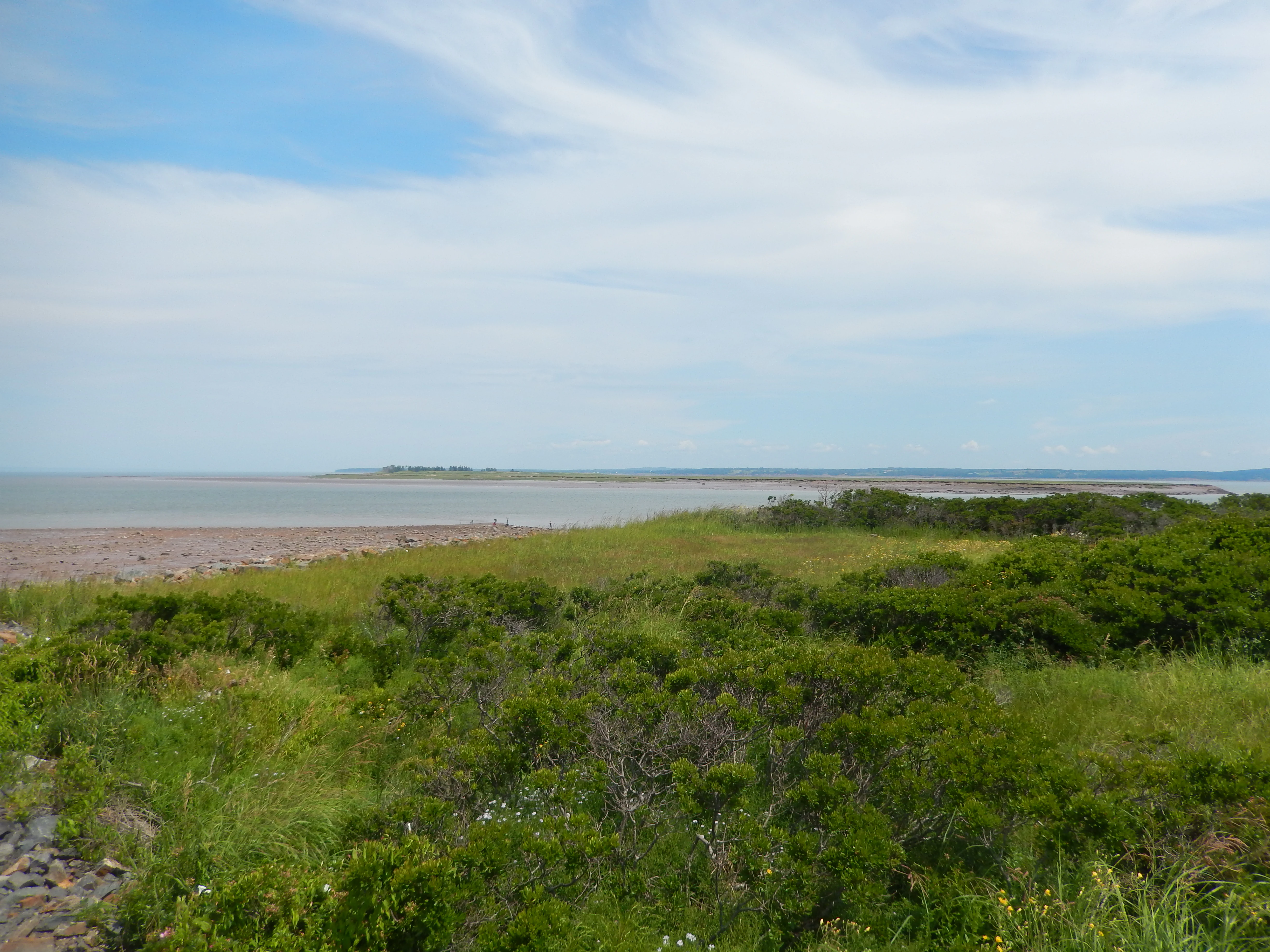
A coastal landscape view showing low-lying green shrubs in the foreground, a sandy beach area, and the ocean under a light blue sky with wispy clouds.
Coastal view of Boot Island National Wildlife Area in Nova Scotia.

Boot Island National Wildlife Area history and protected-area timeline

The Boot Island National Wildlife Area was formally established in 1979 as a federal wildlife reserve under the administration of the Canadian Wildlife Service. Its creation reflected growing awareness of the ecological importance of coastal Nova Scotia, particularly the salt marshes, mudflats, and intertidal zones of the Minas Basin, as critical habitat for migratory waterfowl and shorebirds.

In 1987, the broader wetlands of the Southern Bight and the Minas Basin, of which Boot Island is a part, were designated as a Ramsar site under the international Convention on Wetlands. This recognition underscored the hemispheric importance of the area for migratory birds and brought additional conservation attention to the region. A formal management plan for the reserve was subsequently produced by Environment Canada in 2014, providing updated guidance for the stewardship of the site.

Boot Island National Wildlife Area landscape and geographic character

Boot Island lies within the Southern Bight of the Minas Basin at the head of the Bay of Fundy, a region known for some of the highest tidal ranges in the world. The surrounding seascape is shaped by the daily rise and fall of tides that expose vast mudflats and feed a complex system of salt marshes and tidal creeks. The island itself rises modestly above this dynamic coastal environment, forming a sheltered refuge amid expansive intertidal flats.

The terrain of the reserve reflects the interplay between land and sea typical of the inner Bay of Fundy. Salt-influenced soils, beaches, and marsh margins define the shoreline, while the interior supports vegetation adapted to coastal exposure and seasonal submersion. The surrounding waters of the Minas Basin carry strong tidal currents and high sediment loads, contributing to the constantly shifting character of the basin floor and reinforcing the wild, ever-changing feel of the landscape.

Boot Island National Wildlife Area ecosystems, habitats, and plant life

The natural environment of Boot Island National Wildlife Area is shaped by the extreme tidal cycle of the Minas Basin and its influence on coastal vegetation and habitats. The island and its surrounding waters support salt marshes, intertidal mudflats, and coastal plant communities adapted to saline conditions and regular inundation. These habitats form a transitional zone between marine and terrestrial environments and are central to the area's ecological character.

Within the regional context, the reserve contributes to the ecological diversity of the Southern Bight-Minas Basin system. The combination of island nesting and roosting habitat with adjacent feeding grounds in the mudflats creates conditions favorable for birds that rely on both sheltered land and productive tidal areas. The area's ecological value is closely tied to its role within this larger wetland complex rather than to isolated features of the island itself.

Boot Island National Wildlife Area wildlife and species highlights

Boot Island National Wildlife Area is primarily valued for its importance to birds, particularly waterfowl and shorebirds that depend on the coastal habitats of the Minas Basin. The reserve serves as a gathering and staging area, offering refuge in a region where extensive mudflats provide rich feeding opportunities and sheltered shorelines offer safe roosting sites.

The surrounding Bay of Fundy coast is recognized for its concentrations of migratory species, and Boot Island contributes to the chain of protected sites that sustain populations along the Atlantic Flyway. Beyond birds, the coastal and intertidal habitats support typical Minas Basin fauna adapted to the brackish, tide-driven environment, though the reserve's wildlife significance is most strongly defined by its role for waterfowl and shorebirds.

Boot Island National Wildlife Area conservation status and protection priorities

The conservation significance of Boot Island National Wildlife Area lies in its protection of coastal island habitat within one of Canada's most ecologically important estuarine regions. By maintaining the island as a wildlife reserve under strict protection, the Canadian Wildlife Service helps preserve nesting, roosting, and resting habitat for waterfowl and shorebirds in a setting largely free from human disturbance.

The reserve's inclusion within the larger Southern Bight-Minas Basin Ramsar site, designated in 1987, places it within an internationally recognized wetland framework. This connection strengthens its role in broader migratory bird conservation, as the Minas Basin supports vast numbers of birds each year and is considered a key coastal wetland along the Atlantic Flyway. Ecosystem management at Boot Island is therefore guided not only by national wildlife area policy but also by its contribution to the long-term health of a Ramsar-listed wetland system.

Top sights and standout views in Boot Island National Wildlife Area

Boot Island National Wildlife Area stands out for its compact size, strict protection status, and integration within the internationally recognized Southern Bight-Minas Basin Ramsar site. The reserve's value lies in protecting coastal and intertidal habitats that sustain waterfowl and shorebirds in one of the most dynamic tidal environments in North America.

Its location within the Bay of Fundy system, combined with the influence of extreme tides, salt marshes, and migratory bird pathways, gives Boot Island a focused yet significant role in Canada's network of protected coastal sites.

Best time to visit Boot Island National Wildlife Area

As a non-public wildlife reserve, Boot Island National Wildlife Area is not intended for general visitation. From a purely ecological perspective, however, the seasons that bring migratory waterfowl and shorebirds to the Minas Basin generally shape when the surrounding landscape is most alive with bird activity. Warmer months tend to offer longer daylight, while periods of peak migration are typically associated with shifts in seasonal conditions along the Atlantic coast.
Monthly climate preview

Long term temperature ranges and precipitation averages for Nova Scotia

Boot Island National Wildlife Area Climate Normals and Monthly Weather Patterns

Representative coordinate records show measured monthly temperature variation alongside steady precipitation levels across the conservation area. Examining the complete twelve month climate profile reveals detailed long term weather averages for this protected location.
Annual mean6 °C
-6 °C18 °C
Jan-6°
Feb-5°
Mar-1°
Apr
May
Jun15°
Jul18°
Aug18°
Sep15°
Oct
Nov
Dec-2°
Warmest month
July

18.3 °C

Coolest month
January

-5.8 °C

Wettest month
December

3.7 mm/day

Driest month
July

2.5 mm/day

Park location guide

Geography guide, regional context, and park location map for Boot Island National Wildlife Area

Boot Island National Wildlife Area park geography, regions, and map view in Canada

Understand where Boot Island National Wildlife Area sits in Canada through a broader geographic reading of the surrounding landscape, nearby location context, and its mapped position within the national park landscape.

How Boot Island National Wildlife Area fits into Canada

Canada is a federal parliamentary constitutional monarchy spanning North America from the Atlantic to the Pacific and Arctic Oceans. With a population of over 41 million, it is officially bilingual in English and French at the federal level. The country gained independence from the United Kingdom through a gradual process culminating in 1982.

Wider geography shaping Boot Island National Wildlife Area in Canada

Canada occupies the northern portion of North America, sharing its longest international border with the United States. The country extends from the Atlantic Ocean to the Pacific Ocean and northward into the Arctic Ocean, giving it the longest coastline of any nation.

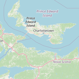
Map view of Boot Island National Wildlife Area

Use this park location map to pinpoint Boot Island National Wildlife Area in Canada, understand its exact geographic position, and read its mapped placement within the surrounding landscape more clearly.

Pigeon | © OpenStreetMap contributors

Location context for Boot Island National Wildlife Area

Nova Scotia

Visualizing intertidal mudflats, salt marshes, and Bay of Fundy habitats

Boot Island National Wildlife Area Photos and Protected Coastal Scenery

Visual documentation of Boot Island National Wildlife Area reveals the dynamic coastal terrain and expansive mudflats shaping the Minas Basin. Examining protected area imagery provides a clearer understanding of how extreme tides and salt marshes define local wildlife habitats.

A coastal landscape view showing low-lying green shrubs in the foreground, a sandy beach area, and the ocean under a light blue sky with wispy clouds.

Park atlas

Compare adjacent coastal habitats, estuarine reserves, and regional protected areas.

Other Parks Near Boot Island National Wildlife Area and Surrounding Protected Lands

Browse other parks near Boot Island National Wildlife Area to examine similar coastal habitats and intertidal environments across the surrounding region. Extending the geographic comparison reveals broader protected wetland networks and connected conservation landscapes along the coast.
Wildlife reserveNova Scotia
About 20 km away#1 closest

West

Kentville Migratory Bird Sanctuary: A Protected Wetland Reserve in the Cornwallis River Valley

Mapped riparian ecosystems and migratory bird habitats in Nova Scotia.

Discover the unique geography of the Kentville Migratory Bird Sanctuary, a compact wildlife reserve in Nova Scotia. This protected area features a blend of river channels, open fields, and forest mosaic that serves as a seasonal sanctuary for waterfowl. Learn about the riparian terrain that defines this critical node in the broader Atlantic flyway network.

Area
5.06 km²
Established
1939
Relief
Lowland
Scope
Terrestrial
A minimalist watercolor illustration showing soft green hills in the distance, a calm body of water, and stylized reddish vegetation in the foreground.
Wildlife reserveNova Scotia
About 59 km away#2 closest

West

Île Haute Wildlife Reserve: Mapped Volcanic Geography and Coastal Protected Terrain

Bay of Fundy protected area, Nova Scotia

Rising abruptly from the Bay of Fundy, Île Haute features a steep, isolated plateau encircled by 100-meter basalt cliffs. This wildlife reserve showcases Jurassic volcanic geology and provides essential habitat for migratory seabirds and marine mammals. Gain insights into the island's unique coastal geography and its role as a protected natural sanctuary in Atlantic Canada.

Area
0.8 km²
Established
2025
Relief
Upland
Scope
Mixed
Watercolor painting of a tranquil marshy wetland with calm water, sparse dead trees, and distant hills under a light, hazy sky.
Wildlife reserveNova Scotia
About 72 km away#3 closest

North

Amherst Point Migratory Bird Sanctuary: Wetland Protected Landscape and Map Explorer

Nova Scotia Wildlife Reserve and Managed Marshland Habitat

Amherst Point Migratory Bird Sanctuary protects a significant freshwater marsh and ponded wetland network in Nova Scotia. This reserve is defined by its engineered diked impoundments and role as a crucial stopover for migratory birds in the Atlantic flyway, offering a clear window into managed wetland conservation and coastal marsh terrain.

Area
4.33 km²
Established
1947
IUCN
IV
National parkNew Brunswick
About 72 km away#4 closest

Northwest

Fundy National Park: New Brunswick National Park Atlas and Geographic Exploration

Mapped protected landscape and regional park context.

Fundy National Park represents a vital protected area, offering rich geographic discovery within New Brunswick, Canada. This national park detail provides context for its mapped boundaries and landscape, supporting atlas-based exploration of its regional significance. Understand Fundy National Park's protected status and its contribution to the mapped natural terrain of eastern Canada.

Area
207 km²
Established
1948
IUCN
II
Visitors
303.6K annual
Watercolor painting of a coastal landscape with green marshlands in the foreground, water, and soft, warm-toned rolling hills in the background.
Wildlife reserveNew Brunswick
About 74 km away#5 closest

Northwest

Réserve nationale de faune de Shepody: Geographic Overview of a New Brunswick Wildlife Reserve

Coastal wetlands and protected intertidal geography

Located along the Bay of Fundy, Réserve nationale de faune de Shepody represents an essential network of salt marshes and freshwater habitats. This mapping analysis traces the intersection of tidal dynamics, riverine estuaries, and ancient sandstone formations that define this critical protected area in New Brunswick.

Area
10.69 km²
Established
1980
IUCN
IV
Relief
Lowland
Watercolor painting showing a river landscape with green trees, rolling hills, and mountains in the background
National parkNova Scotia
About 108 km away#6 closest

Southwest

Kejimkujik National Park: Detailed Protected Landscape and Regional Geography

Explore mapped boundaries and geographic context in Nova Scotia.

Kejimkujik National Park offers a dedicated entry for understanding protected natural areas. As a national park in Nova Scotia, its geographic features and protected boundaries are detailed here to support atlas-based exploration. Discover the park's unique landscape context and its positioning within regional geography, providing a factual basis for comprehending its role as a conservation area.

Area
404 km²
Established
1967
IUCN
II
Visitors
75.3K annual
A horizontal watercolor painting showing a pale green and soft pink landscape with distant hills, a calm body of water, and a tree-lined shore.
Wildlife reserveNew Brunswick
About 118 km away#7 closest

North

Réserve nationale de faune du Cap-Jourimain: Protected Coastal Wetlands and Wildlife Maps

Essential geographic context for a strategic New Brunswick wildlife reserve

Examine the mapped boundaries and complex ecosystem transitions of Réserve nationale de faune du Cap-Jourimain. This federally protected area in New Brunswick offers a distinct look at coastal marshlands, tidal flats, and island topography situated at the narrowest point of the Northumberland Strait.

Area
6.617 km²
Established
1980
IUCN
IV
Relief
Lowland
Wildlife reserveNova Scotia
About 152 km away#8 closest

South

Zugvogelschutzgebiet Port Hebert: Coastal Protected Landscapes of Nova Scotia

Wildlife reserve and intertidal wetland geography

Spanning the shallow reaches of Port L'Hebert, this wildlife reserve serves as a foundational element of the South Shore protected area network. The sanctuary is defined by its wide tidal range, which uncovers extensive sand and mudflats to provide essential feeding grounds for migratory geese and ducks. This site offers deep insight into the coastal geography and wetland preservation status of Nova Scotia's rugged Atlantic fringe.

Area
3.46 km²
Established
1941
IUCN
Ia

Common questions about visiting, size, designation, and location context for Boot Island National Wildlife Area

Boot Island National Wildlife Area FAQs for park facts, access, geography, and protected area context

Find quick answers about Boot Island National Wildlife Area, including protected-area facts, park geography, trail and visitor context, and how the park fits into its surrounding country and regional landscape.
MoriAtlas Explorer

Continue Your Protected Areas Search Across the Global Atlas

Deepen your exploration by continuing the structured search for national parks and protected areas worldwide. Utilize the comprehensive filtering capabilities to compare different conservation landscapes and refine your understanding of global park geography. Discover more about the distribution and characteristics of protected natural areas.

Global natural geography