
Mori Atlas logo
Protected landscapeBrodnicki Park Krajobrazowy

Examine the post-glacial terrain and water-rich corridors of this Polish protected area

Brodnicki Park Krajobrazowy: A Protected Landscape of Glacial Lakes and Moraine Topography

Brodnicki Park Krajobrazowy serves as a premier example of a young-glacial landscape, defined by its intricate system of parallel tunnel valleys, moraine uplands, and outwash plains. This protected area within the Kuyavian-Pomeranian Voivodeship hosts dozens of lakes, extensive peatlands, and diverse forest communities, including rare oak-hornbeam and alder swamps. The geography showcases a coherent water-rich system shaped by the Baltic ice sheet, providing a distinct window into the natural history of the Polish lowlands.

lake districtglacial landscapemorainetunnel valleypeatlandbog
A digital illustration showing a wide body of water with green pine trees on the banks and pink rocky cliffs in the background under a pale yellow sky with clouds.

Brodnicki Park Krajobrazowy

Protected landscape

Park overview

Structured park overview, official facts, and landscape profile for Brodnicki Park Krajobrazowy

Brodnicki Park Krajobrazowy park facts, protected area profile, and essential visitor context

Review the core facts for Brodnicki Park Krajobrazowy, including designation, size, terrain, visitor scale, habitats, and operating context in one park-focused overview.

About Brodnicki Park Krajobrazowy

Brodnicki Park Krajobrazowy protects a representative fragment of the young-glacial landscape of northern Poland, where the interplay of ice-age landforms, water systems, and forest communities creates one of the most characteristic regional environments of the Polish lowlands. The park is organized around three glacial tunnel valleys, formed by meltwater beneath the retreating ice sheet of the Baltic glaciation. These valleys cut through moraine uplands and outwash plains, producing the highly varied relief that defines the area.

The eastern tunnel valley hosts the Skarlanka river and a chain of lakes including Wielkie Partęczyny, Robotno, and Dębno. The western valley runs through Brodnica Struga and connects lakes Mieliwo, Sosno, and Łęckie. The central valley contains Lakes Ciche and Zbiczno. Together these corridors link lakes, peatlands, and streams into a single hydrological network that covers roughly eight percent of the park's surface. The surrounding moraine plateau is forested, giving the park its classic forest-and-lake character.

Ecologically, the park combines four major environments: lakes, peat bogs, deciduous forests, and pine-dominated woodlands. It hosts more than fifty lakes over one hectare in size, with the largest lake systems occupying nearly 1,790 ha, and roughly forty percent of the park is covered by forest. Its reserve network protects peatlands, forest stands, the Drwęca river, and a botanical island in Lake Wielkie Partęczyny. The park also preserves a significant cultural layer, including early medieval hillforts, manor ensembles, and traditional rural architecture of the 18th and 19th centuries, which gives the protected landscape an additional historical dimension.

Quick facts and research context for Brodnicki Park Krajobrazowy

Brodnicki Park Krajobrazowy is a landscape park (park krajobrazowy) in northern Poland, officially designated on 29 March 1985 by the Provincial National Council in Toruń. It was the 25th landscape park established in Poland and was expanded in 2005 to incorporate Lake Bachotek and the Boggy Drwęca Valley.

The park spans two voivodeships, Kuyavian-Pomeranian and Warmian-Masurian, and covers an area of roughly 16,685 ha following its 2005 extension. It contains nine nature reserves of varying character, including peatland, forest, river, and floristic reserves, and is associated with the Brodnica Lake District and the Drwęca Valley mesoregions.

Protection and recognition

Explore documented terrestrial protection scopes and official recognition records

Brodnicki Park Krajobrazowy Protection Status and Designated Landscape Management

Brodnicki Park Krajobrazowy maintains a documented terrestrial protection scope within its regional conservation framework. Official records compile available designation details and management parameters for geographic reference.

Protection details

Protection scope
Terrestrial
Transboundary protection
No
Buffer area
117.78 km²
Park context

Deeper park guide and search-rich context for Brodnicki Park Krajobrazowy

Brodnicki Park Krajobrazowy history, landscape, wildlife, and travel context

Explore Brodnicki Park Krajobrazowy through its history, landscape character, ecosystems, wildlife, conservation priorities, cultural context, and seasonal travel timing in a structured park guide built for atlas discovery and search intent.

Why Brodnicki Park Krajobrazowy stands out

Brodnicki Park Krajobrazowy is best known for its classic young-glacial landscape: a mosaic of moraine uplands, tunnel valleys, lakes, and peat bogs shaped during the Baltic glaciation. The park is especially notable for its three parallel glacial channels, each filled with chains of lakes and streams, which together form one of the most representative examples of tunnel-valley topography in the Polish lowlands. The park is also recognized for its rich forest cover, with Scots pine as the dominant tree, alongside oak, birch, beech, hornbeam, and ash. It marks an important biogeographical boundary, where the natural ranges of beech and wild service tree meet, and where notable bog, oak-hornbeam, and alder swamp communities support rare plant species.
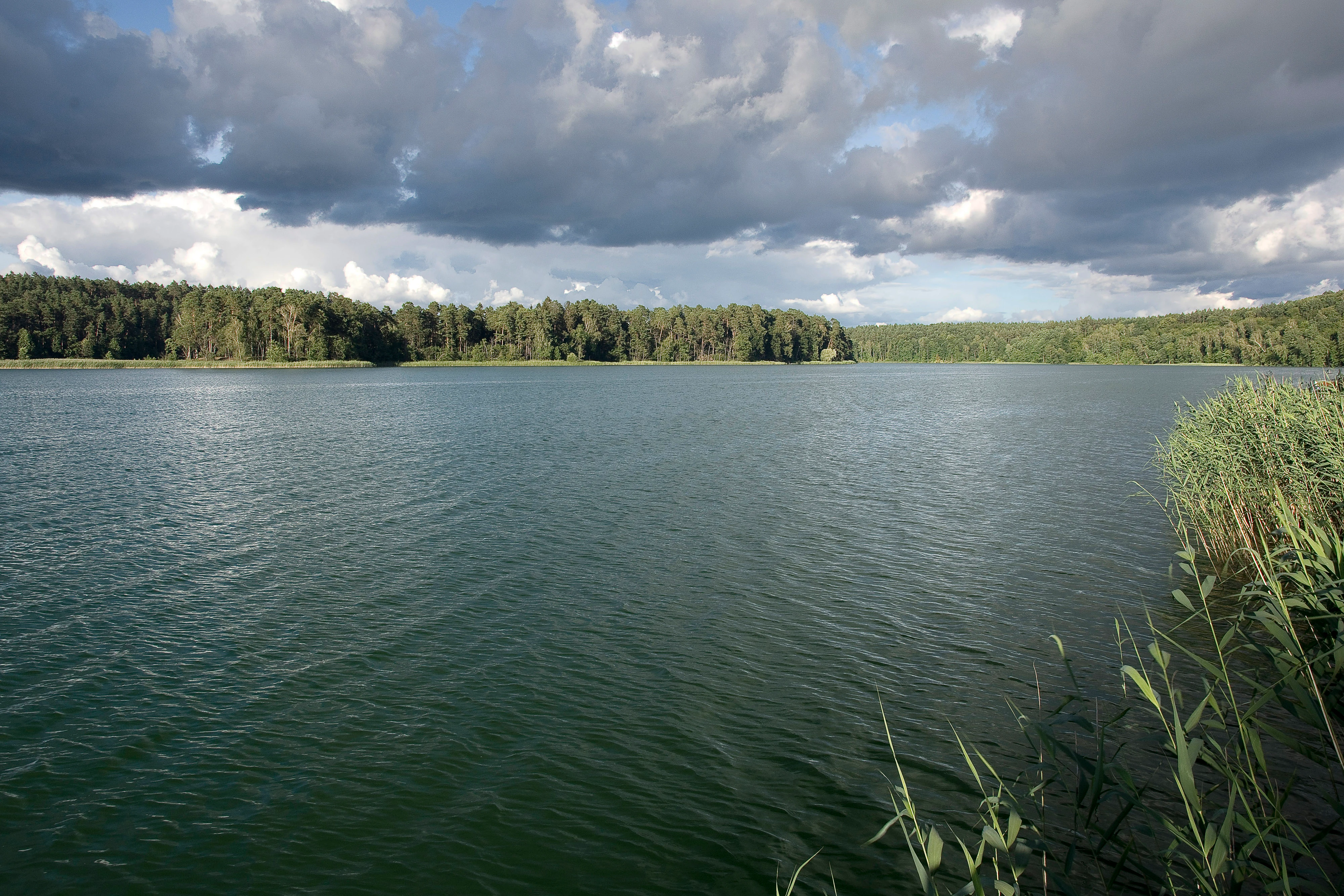
A wide lake with greenish-blue rippling water, bordered by a dense forest on the far shore, with tall reeds in the foreground right and a cloudy sky above
View of Zbiczno Lake with forested shoreline under a dramatic cloudy sky

Brodnicki Park Krajobrazowy history and protected-area timeline

The idea of establishing a landscape park in the Brodnica area predates World War II and is most closely associated with Professor Zygmunt Czubiński, an early advocate for this type of nature protection in Poland. Before 1945 he had already proposed protecting the landscapes that would later form the heart of the park.

After 1945, the most valuable areas he highlighted were placed under stricter reserve protection, building the foundation for a broader landscape-level designation. The park was formally created on 29 March 1985 by resolution of the Provincial National Council in Toruń, becoming the 25th landscape park in Poland. At its creation, the park covered about 10,462 ha, with an additional buffer zone of about 11,778 ha.

In 2005 the park was significantly expanded, gaining Lake Bachotek and the so-called Boggy Drwęca Valley. As a result, the park's total area now exceeds 16,600 ha and includes a much more complete representation of the region's lake and wetland systems.

Brodnicki Park Krajobrazowy landscape and geographic character

The physical landscape of Brodnicki Park Krajobrazowy is a textbook example of young-glacial terrain. Its relief is dominated by rolling moraine uplands, dissected by three prominent tunnel valleys, which run parallel across the southern part of the park. The uplands are dotted with kettle depressions, many of which are filled with lakes or peat bogs, giving the terrain a distinctive hummocky character.

Outwash plains (sandrs) extend across parts of the area as well, providing flatter, sandier terrain that contrasts with the more rugged moraine plateaus. The tunnel valleys themselves form continuous corridors of water and wetland, linking the lakes of Wielkie Partęczyny, Robotno, Dębno, Sosno, Mieliwo, and Zbiczno through slow streams and channels.

Water is a defining feature of the landscape, occupying about eight percent of the park's surface. Forests cover much of the surrounding uplands, creating the typical Polish lakeland scenery of wooded hills, hidden lakes, and open bog valleys. Together, these elements produce a forested lake district landscape that is both visually striking and ecologically coherent.

Brodnicki Park Krajobrazowy ecosystems, habitats, and plant life

Brodnicki Park Krajobrazowy is defined ecologically by a close relationship between water, peatland, and forest. The park's environmental mosaic includes deep and shallow lakes, transition mires, raised bogs, low moors, river corridors, pine-dominated forests, mixed forests, oak-hornbeam woodlands, and alder swamps, creating multiple overlapping habitats within a relatively compact area.

Forests span about forty percent of the park, with Scots pine as the dominant tree species. Mixed pine forests are the most widespread forest community, while fresh pine forests are also abundant. Broadleaf communities include oak-hornbeam forests, which host characteristic spring flora such as wood anemones, lesser celandine, hollowroot, and locally rare species. Alder swamp forests provide habitat for royal fern, while oak-hornbeam stands support large-flowered lady's slipper.

The park sits at an important biogeographical boundary, marking the limits of natural beech and wild service tree distribution, and lying near the edge of natural Polish larch, sycamore maple, and yew range. Peatlands are the second key habitat type, with the Okonek peatlands having been protected since before 1939. Several rare or regionally notable plant species, including willow-leaved peat willow, are recorded here, and the Brocken heathberry is abundant in the dry pine forests.

Brodnicki Park Krajobrazowy wildlife and species highlights

While the source material focuses primarily on habitats and plant communities, the park's mosaic of lakes, peatlands, rivers, and forests supports a rich and varied wildlife profile typical of the Polish lake districts. The combination of large open water bodies and extensive peat bogs is especially favorable for waterfowl, including breeding and migratory species, as well as wetland specialists associated with marsh and bog habitats.

The forest cover provides habitat for typical lowland forest mammals, while the river reserves and aquatic systems sustain fish and invertebrate communities relevant for conservation. The presence of a dedicated faunal reserve along the Drwęca river reflects the recognized importance of the area's aquatic and riparian wildlife. Although specific species lists are not detailed in the available source, the park's habitat variety ensures strong representation of aquatic, wetland, forest-floor, and woodland-edge fauna.

Brodnicki Park Krajobrazowy conservation status and protection priorities

Brodnicki Park Krajobrazowy plays a substantial role in regional conservation, both as a broad landscape-level protection area and as a host of nine nature reserves covering peatlands, forests, a river, and a botanical island. This layered protection structure safeguards some of the most ecologically valuable components of the wider Brodnica Lake District.

The park's conservation significance lies in its integration of hydrological, ecological, and biogeographical values. It protects a coherent system of glacial lakes, peatlands, and forests, including sites that were already protected as reserves before World War II. The 2005 extension, adding Lake Bachotek and the Boggy Drwęca Valley, further strengthened conservation of wetland and riverine habitats.

Beyond local importance, the park contributes a representative example of the Polish young-glacial landscape to the national network of protected areas. It also marks important biogeographical boundaries, helping conserve range-edge populations of beech, wild service tree, and other species, and supports rare plant communities such as oak-hornbeam forests with large-flowered lady's slipper and alder swamps with royal fern.

Brodnicki Park Krajobrazowy cultural meaning and human context

The cultural dimension of Brodnicki Park Krajobrazowy is closely tied to its landscape. Early medieval hillforts overlook lakes Strażym, Sosno, and Kurzyny, reflecting the strategic importance of lake-shore settlements in the region during the early Middle Ages and giving the park strong archaeological value.

Manor and palace estates at Sumowo, Tomki, and Konojady, as well as traditional rural architecture from the 18th and 19th centuries in villages such as Ciche, Gaj-Grzmięca, and Górale, add a built-heritage layer to the landscape. Numerous sacred objects further enrich the cultural fabric of the area. Together, these elements frame the protected natural environment within a broader regional identity that combines nature conservation with long-standing human settlement.

Top sights and standout views in Brodnicki Park Krajobrazowy

Brodnicki Park Krajobrazowy stands out for the clarity of its post-glacial landforms: three parallel tunnel valleys, moraine uplands, and outwash plains create a textbook young-glacial landscape. The park contains fifty-eight lakes larger than one hectare, with the largest systems covering nearly 1,790 ha, while peatlands, with the historic Okonek peatland complex, add further ecological depth.

The forest cover, dominated by Scots pine but rich in oak, birch, beech, and hornbeam, marks important biogeographical boundaries for beech and wild service tree, and supports communities such as mixed pine forest, fresh pine forest, oak-hornbeam forest, and alder swamp that host rare and regionally notable plant species. The 2005 expansion brought in Lake Bachotek and the Boggy Drwęca Valley, extending the protected system of lakes, peatlands, and rivers, while cultural sites such as early medieval hillforts, manor estates, and traditional villages connect the natural park to a long regional heritage.

Best time to visit Brodnicki Park Krajobrazowy

The park's young-glacial landscape is attractive throughout the year, but each season gives it a distinct character. Late spring and early summer are especially vivid, when lakes are ringed with fresh foliage, broadleaf forests come into leaf, and the wetland valleys are at their most biologically active. This is also a productive period for observing wetland habitats and forest-floor flora.

Summer offers long daylight for water-based recreation and easy access to the lake-and-forest scenery, while autumn brings intense color in the deciduous stands and quieter conditions across the reserve network. Winter transforms the lake district into a muted, snow-covered landscape, highlighting the contrast between open bogs, frozen lakes, and dark conifer stands, and offering a different, more contemplative perspective on the park's glacial landforms.
Monthly climate preview

Long-term representative records of monthly temperature and precipitation patterns

Brodnicki Park Krajobrazowy Climate Normals and Annual Temperature Range

Representative coordinate sampling from 1991 to 2020 documents measured temperature bounds and daily precipitation rates across twelve months in Brodnicki Park Krajobrazowy. Detailed monthly climate profiles reveal complete historical data variations for this protected landscape.
Annual mean8 °C
-4 °C19 °C
Jan-4°
Feb-2°
Mar
Apr
May13°
Jun17°
Jul19°
Aug19°
Sep14°
Oct
Nov
Dec-2°
Warmest month
July

19.1 °C

Coolest month
January

-3.6 °C

Wettest month
July

2.6 mm/day

Driest month
April

1.4 mm/day

Park location guide

Geography guide, regional context, and park location map for Brodnicki Park Krajobrazowy

Brodnicki Park Krajobrazowy park geography, regions, and map view in Poland

Understand where Brodnicki Park Krajobrazowy sits in Poland through a broader geographic reading of the surrounding landscape, nearby location context, and its mapped position within the national park landscape.

How Brodnicki Park Krajobrazowy fits into Poland

Poland, officially the Republic of Poland, is a Central European country spanning from the Baltic Sea in the north to the Carpathian Mountains in the south. It borders Germany, Czech Republic, Slovakia, Ukraine, Belarus, Lithuania, and Kaliningrad Oblast. The country has a temperate climate, diverse landscapes, and is known for its rich history, cultural heritage, and strong economic position within the EU.

Wider geography shaping Brodnicki Park Krajobrazowy in Poland

Poland occupies 312,696 km2 in Central Europe, extending from the Baltic Sea coast in the north to the Sudetes and Carpathian Mountains in the south. It borders Germany to the west, Czech Republic and Slovakia to the south, Ukraine and Belarus to the east, and Lithuania and Kaliningrad Oblast to the northeast. The landscape includes lowland plains, uplands, and mountain ranges.

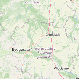
Map view of Brodnicki Park Krajobrazowy

Use this park location map to pinpoint Brodnicki Park Krajobrazowy in Poland, understand its exact geographic position, and read its mapped placement within the surrounding landscape more clearly.

Pigeon | © OpenStreetMap contributors

Location context for Brodnicki Park Krajobrazowy

Kuyavian-Pomeranian VoivodeshipWarmian-Masurian Voivodeship

Visualizing the moraine uplands, tunnel valleys, and forest habitats of northern Poland

Brodnicki Park Krajobrazowy Photos and Glacial Landscape Scenery

Photographic collections reveal the complex post glacial terrain, parallel lake chains, and dense pine forests defining Brodnicki Park Krajobrazowy. Visual documentation provides clear insight into the protected wetlands, meltwater channels, and unique aquatic habitats characterizing this northern lowland ecosystem.

A wide lake with greenish-blue rippling water, bordered by a dense forest on the far shore, with tall reeds in the foreground right and a cloudy sky above

Park atlas

Compare adjacent post-glacial terrain, tunnel valleys, and lake districts in northern Poland.

Parks Near Brodnicki Park Krajobrazowy and Surrounding Protected Landscapes

Browsing other protected areas near Brodnicki Park Krajobrazowy reveals shared young-glacial topography, moraine uplands, and interconnected lake systems across the region. Expanding the geographic comparison provides a clearer understanding of the wider natural context defining the Polish lowlands.
Nature reserveKuyavian-Pomeranian Voivodeship
Mapped location lies within the park boundary#1 closest

West

Rezerwat przyrody Mieliwo Nature Reserve: Protected Forest and Glacial Valley Geography

A scientific forest study site within the Brodnica Lake District landscape

This protected forest reserve in the Kuyavian-Pomeranian Voivodeship is defined by its position on a high glacial slope above Lake Mieliwo. It remains a key reference point for studying beech forest stands at the northern edge of their range, contributing to the regional conservation of the Brodnica Lake District and its post-glacial valley network.

Area
0.117 km²
Established
1958
Relief
Upland
Scope
Terrestrial
Nature reserveWarmian-Masurian Voivodeship
About 0.6 km away#2 closest

East

Rezerwat przyrody Jezioro Mścin: Protected Wetland Landscapes and Regional Geography

Nature reserve habitat in the Brodnica Lake District

Rezerwat przyrody Jezioro Mścin serves as a primary example of successful wetland restoration for biodiversity conservation. Situated in the Warmian-Masurian Voivodeship, this faunistic reserve integrates open water, marsh, and forest edges to support waterfowl and migratory bird populations within a broader regional network of protected Polish landscapes.

Area
0.499 km²
Established
2024
Relief
Lowland
Climate
Temperate
A horizontal watercolor illustration depicting a soft, pale green and reddish wetland environment with scattered trees and marsh vegetation.
Nature reserveKuyavian-Pomeranian Voivodeship
16 km away#3 closest

Southeast

Mszar Płociczno Nature Reserve: Protected Peatland Geography and Landscape Boundaries in Poland

Regional protected area analysis for Kuyavian-Pomeranian landscape maps.

The Mszar Płociczno nature reserve acts as a critical refuge for transitional peatland, harboring a mosaic of Sphagnum mires, swamp forests, and coniferous woodland. This area functions as a key component of the Brodnica peatland ecological network, demonstrating long-term conservation success within the flat terrain of the Równina Urszulewska mesoregion.

Area
1.824 km²
Established
1997
Relief
Lowland
Scope
Terrestrial
Protected landscapeWarmian-Masurian Voivodeship
About 17 km away#4 closest

East

Welski Park Krajobrazowy: Regional Protected Landscape in the Warmian-Masurian Voivodeship

Mapping glacial landforms and river valley ecosystems

The landscape of Welski Park Krajobrazowy is a study in Pleistocene glacial history, defined by the interplay between sandy outwash plains and morainic uplands. This protected area in the Warmian-Masurian Voivodeship shelters a series of thirteen significant post-glacial lakes and the Wel river valley, creating a dense network of wetlands, forest habitats, and geologic features perfect for atlas-based geographic study.

Area
200.233 km²
Established
1995
Relief
Lowland
Access
Easy access
Nature reserveKuyavian-Pomeranian Voivodeship
About 20 km away#5 closest

Northwest

Rezerwat przyrody Dolina Osy: Geographic Atlas of an Osa River Valley Protected Area

Riverine landscapes in the Kuyavian-Pomeranian Voivodeship

This nature reserve serves as a prime example of post-glacial river valley preservation in the Chełmińskie Lakeland. The protected area features a diverse mosaic of lowland valley terrain, including river channels, wet bottomlands, and woodland corridors, illustrating the complex geography of north-central Poland.

Area
6.679 km²
Established
1994
Relief
Upland
Climate
Temperate
Nature reserveWarmian-Masurian Voivodeship
About 22 km away#6 closest

East

Jezioro Neliwa Nature Reserve: Mapping Protected Landscapes and Glacial Lake Geography

An important eutrophic water reserve in the Warmian-Masurian Voivodeship.

Located within the Welski Landscape Park, this nature reserve protects a vanishing eutrophic lake ecosystem and its unique slope oak-lime forest. The area provides essential habitat for breeding bird populations and rare aquatic plant species, serving as a vital point of study for lowland glacial geography in northeastern Poland.

Area
0.165 km²
Established
2006
Water
Water-dominated
Protected landscapeWarmian-Masurian Voivodeship
27 km away#7 closest

Northeast

Park Krajobrazowy Wzgórz Dylewskich: Protected Moraine Terrain and Regional Geography

A study of glacial landforms and hydrological patterns in the Warmian-Masurian Voivodeship

Explore the unique geomorphology of Park Krajobrazowy Wzgórz Dylewskich, where Pleistocene glaciation has carved steep slopes, deep valleys, and expansive hill summits. This protected landscape serves as a central hub for regional biodiversity and acts as a primary source for radiating water networks in northern Poland, offering a high-relief counterpoint to the surrounding lakeland.

Area
71.7 km²
Established
1994
Relief
Mountain
Scope
Terrestrial
Nature reserveWarmian-Masurian Voivodeship
About 37 km away#8 closest

Northeast

Dylewo Nature Reserve: Protected Beech Woodland in the Warmian-Masurian Voivodeship

A study of glacial topography and rare fern habitats

Located within the Wzgórza Dylewskie landscape park, Dylewo Nature Reserve protects a stable, closed-canopy beech woodland on elevated morainic terrain. Gain deeper insights into the forest composition and the ecological importance of this site as a sheltered habitat for rare flora within the larger northern Polish lakeland region.

Area
0.101 km²
Established
1970
Relief
Mountain
Scope
Terrestrial

Common questions about visiting, size, designation, and location context for Brodnicki Park Krajobrazowy

Brodnicki Park Krajobrazowy FAQs for park facts, access, geography, and protected area context

Find quick answers about Brodnicki Park Krajobrazowy, including protected-area facts, park geography, trail and visitor context, and how the park fits into its surrounding country and regional landscape.
MoriAtlas Explorer

Continue Your Protected Areas Search Across the Global Atlas

Deepen your exploration by continuing the structured search for national parks and protected areas worldwide. Utilize the comprehensive filtering capabilities to compare different conservation landscapes and refine your understanding of global park geography. Discover more about the distribution and characteristics of protected natural areas.

Global natural geography