

Mori Atlas logo
Nature reserveBrooklyn Sanctuary

Mapping the dramatic ecological transition between the Mount Carbine Tableland and Mitchell River catchment

Brooklyn Sanctuary Nature Reserve: Exploring the Geography of this Queensland Protected Landscape

Brooklyn Sanctuary stands as a significant protected landscape in northeastern Queensland, spanning 600 square kilometres of diverse terrain. It encompasses a striking environmental gradient, rising from the rugged, rainforested peaks of the Mount Carbine Tableland down to the drier, open alluvial plains of the Mitchell River basin. This nature reserve serves as a critical junction for biodiversity by bridging the Wet Tropics and the Einasleigh Uplands bioregions, protecting a complex mosaic of rainforest, wet sclerophyll forest, and melaleuca gallery woodland.

nature reserveprivate reservetropical rainforestwet sclerophyll foresteucalypt woodlandmelaleuca gallery forest

Brooklyn Sanctuary

Nature reserve

Park overview

Structured park overview, official facts, and landscape profile for Brooklyn Sanctuary

Brooklyn Sanctuary park facts, protected area profile, and essential visitor context

Review the core facts for Brooklyn Sanctuary, including designation, size, terrain, visitor scale, habitats, and operating context in one park-focused overview.

About Brooklyn Sanctuary

Brooklyn Sanctuary is one of the largest private nature reserves in tropical Australia, forming a 600 square kilometre block of protected landscape on the Mount Carbine Tableland in north-east Queensland. Less than 100 kilometres north-west of Cairns, it sits at a biogeographically critical interface between the Wet Tropics and the Einasleigh Uplands, a position that gives the property unusually high conservation value.

The sanctuary is owned and managed by the Australian Wildlife Conservancy, which acquired it in 2004 as part of its mission to protect Australia's threatened species through large-scale private land conservation. A portion of the property is inscribed on the World Heritage List, recognising its contribution to the broader tropical rainforest heritage of the region.

What makes Brooklyn particularly distinctive is the sheer range of environments packed into a single tenure. The northern and more elevated portions of the reserve climb to around 1,200 metres and carry dense rainforest under a very wet climate with approximately 4,000 millimetres of annual rainfall. The southern and lower portions flatten into drier plains in the upper Mitchell River system, where rainfall falls below 900 millimetres and vegetation shifts to open woodlands and floodplain communities.

This internal climate gradient supports an unusually broad cross-section of ecosystems. Visitors and managers encounter wet and dry rainforests, wet sclerophyll forests, mixed eucalypt woodlands, melaleuca-dominated gallery forests along watercourses, and shallow lakes set on alluvial plains. Together, these habitats form a near-continuous bridge between two of Australia's most ecologically distinct tropical bioregions.

Quick facts and research context for Brooklyn Sanctuary

Brooklyn Sanctuary is a 600 square kilometre private nature reserve in north-east Queensland, Australia, located less than 100 kilometres north-west of Cairns. It is owned and managed by the Australian Wildlife Conservancy, which acquired the property in 2004.

The reserve lies on the Mount Carbine Tableland at the boundary between the Wet Tropics bioregion and the Einasleigh Uplands bioregion, transitioning from rainforested peaks receiving around 4,000 millimetres of annual rainfall to drier lowland plains of the upper Mitchell River with less than 900 millimetres. A portion of the property is inscribed on the World Heritage List.

Protection and recognition

Documented conservation parameters and international designation records for Brooklyn Sanctuary.

Brooklyn Sanctuary Protection Status, Terrestrial Scope, and Recognition Data

Brooklyn Sanctuary maintains a documented terrestrial protection scope within the global conservation registry. Official records compile management boundaries, designation details, and formal recognition sources for this protected natural area.

Protection details

Protection scope
Terrestrial
Transboundary protection
No
Park context

Deeper park guide and search-rich context for Brooklyn Sanctuary

Brooklyn Sanctuary history, landscape, wildlife, and travel context

Explore Brooklyn Sanctuary through its history, landscape character, ecosystems, wildlife, conservation priorities, cultural context, and seasonal travel timing in a structured park guide built for atlas discovery and search intent.

Why Brooklyn Sanctuary stands out

Brooklyn Sanctuary is best known for protecting a striking gradient of tropical environments within a single property, from high-altitude rainforests on the Mount Carbine Tableland to drier lowland woodlands of the Mitchell River catchment. This rare junction of bioregions makes it especially valuable for upland endemic species and for species that depend on both wet forest and drier woodland habitats. The reserve is also notable for its concentration of threatened tropical wildlife, including southern cassowary, buff-breasted button-quail and red goshawk among birds, and northern bettong, yellow-bellied glider, spotted-tailed quoll and spectacled flying-fox among mammals. A relict population of bunya pine adds to its botanical significance.
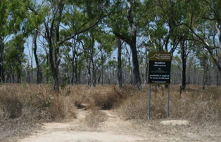
A metal information sign stands on a dirt path in a dry woodland area, identifying the location as Brooklyn Sanctuary.
Entrance signage at Brooklyn Sanctuary in Queensland.

Brooklyn Sanctuary history and protected-area timeline

Brooklyn Sanctuary was acquired by the Australian Wildlife Conservancy in 2004, becoming part of a network of large-scale private reserves managed for the long-term survival of Australia's threatened wildlife. Its establishment reflected a growing recognition that private land conservation could play a major role in protecting tropical ecosystems outside formal government reserves.

The property's ecological importance was further reinforced when part of it was inscribed on the World Heritage List, recognising its contribution to the rainforest heritage of the Wet Tropics region.

Details of earlier land use, pastoral history or pre-acquisition tenure are not strongly documented in the available source material, and the broader history of conservation management at Brooklyn is instead framed primarily around the 2004 acquisition and ongoing management by the Conservancy.

Brooklyn Sanctuary landscape and geographic character

The landscape of Brooklyn Sanctuary is shaped by the Mount Carbine Tableland, a rugged upland that gives way to flatter terrain towards the upper Mitchell River drainage in the south. Altitudes rise to roughly 1,200 metres on the forested peaks, while the lowland plains drop into the drier Mitchell River country.

This elevation range drives one of the sanctuary's defining characteristics: a steep rainfall gradient within a short distance. Higher elevation slopes receive around 4,000 millimetres of rain a year, supporting dense rainforest and persistent cloud forest conditions, while the lowlands receive less than 900 millimetres and carry a much drier, open vegetation character.

The result is a landscape of contrast: steep rainforested ridges and gorges near the higher ground, and broad alluvial plains with lakes, gallery forests and seasonal waterbodies further south. The combination of rugged upland and open lowland gives Brooklyn a strong sense of geographic variety.

Brooklyn Sanctuary ecosystems, habitats, and plant life

Brooklyn sits on the ecological boundary between the Wet Tropics and the Einasleigh Uplands bioregions, allowing it to combine species and vegetation types that rarely occur together. The reserve's ecosystems include a spectrum of rainforest types, wet sclerophyll forests, mixed eucalypt woodlands, melaleuca-dominated gallery forests along waterways, and shallow lakes on alluvial plains.

Wet sclerophyll forest, where tall eucalypts rise above a rainforest understorey, is a particularly characteristic formation here, reflecting the transition from rainforest to drier woodland as rainfall declines. The melaleuca gallery forests lining watercourses and the open eucalypt woodlands of the lower country add further diversity.

The reserve also supports a relict population of bunya pine, a distinctive conifer with a naturally restricted distribution in southern Queensland and north-eastern New South Wales. Its presence at Brooklyn adds botanical significance to the property and reflects the reserve's value as a refuge for plant species at the edges of their historical range.

Brooklyn Sanctuary wildlife and species highlights

Brooklyn Sanctuary is recognised for the richness of its tropical fauna and for the threatened species it sustains. Among birds, notable records include the southern cassowary, a large flightless rainforest species closely associated with wet tropical habitats, as well as the buff-breasted button-quail and the red goshawk, both considered threatened in Australia.

The mammal fauna is similarly varied. Northern bettong, a small marsupial that depends on grassy understorey beneath open forest, is present along with the yellow-bellied glider, a highly mobile gliding possum of tall forests. The spotted-tailed quoll, one of Australia's last large marsupial predators, and the spectacled flying-fox, a fruit bat of tropical rainforests, also occur on the property.

The mix of rainforest, woodland and floodplain habitats allows a combination of species typical of both the Wet Tropics and the drier uplands to coexist within the sanctuary, giving it unusually high conservation value for tropical wildlife.

Brooklyn Sanctuary conservation status and protection priorities

Brooklyn Sanctuary is nationally significant for the conservation of upland endemic species, particularly those caught between the Wet Tropics and the Einasleigh Uplands bioregions. Its size, around 600 square kilometres, makes it large enough to support ecologically functional populations of wide-ranging mammals and birds that smaller reserves cannot sustain.

The property's inclusion of part of a World Heritage-listed landscape reinforces its conservation importance. The combination of private reserve status and World Heritage recognition provides a strong dual framework for protecting both the rainforest heritage and the drier upland systems within the sanctuary.

Management by the Australian Wildlife Conservancy, an organisation dedicated to conserving threatened wildlife through large-scale private reserves, adds a coordinated conservation focus. The sanctuary is used both as a refuge for threatened tropical species and, implicitly, as a benchmark for landscape-scale conservation across the Wet Tropics, savanna uplands and Mitchell River catchments of Far North Queensland.

Top sights and standout views in Brooklyn Sanctuary

The strongest highlights of Brooklyn Sanctuary are its dramatic environment gradient from rainforest peaks to drier lowland plains, its position at the meeting point of the Wet Tropics and Einasleigh Uplands bioregions, and its role in protecting upland endemic and threatened species of Far North Queensland.

Part of the property bears World Heritage recognition, and the reserve supports an unusually broad mix of rainforest types, wet sclerophyll forest, mixed eucalypt woodland, melaleuca gallery forest and floodplain lakes. A relict population of bunya pine further adds to its botanical distinctiveness.

Best time to visit Brooklyn Sanctuary

As a private nature reserve managed for conservation, Brooklyn Sanctuary is not framed as a conventional visitor destination in the available source material, and detailed seasonal visitation guidance is limited. In broad terms, the cooler and drier months of the Australian late autumn, winter and early spring tend to offer more comfortable conditions in tropical north Queensland, with reduced humidity and lower rainfall, while the warmer and wetter summer months bring heavier rain, lush vegetation growth and more active wildlife, but also higher humidity and the possibility of flooding on lowland plains.

Anyone planning to engage with the sanctuary for research, conservation volunteering or guided visits should treat seasonality as a secondary consideration compared with the reserve's conservation priorities and access arrangements, which are determined by the Australian Wildlife Conservancy.


Monthly climate preview

Long-term representative temperature ranges and monthly precipitation patterns

Brooklyn Sanctuary Climate Normals and Measured Annual Weather by Month

Brooklyn Sanctuary records measured long-term averages for monthly temperature and precipitation based on historical coordinates in Queensland. Exploring the complete twelve-month climatology profile reveals detailed patterns across seasonal shifts.
Annual mean22 °C
18 °C25 °C
Jan25°
Feb24°
Mar23°
Apr22°
May20°
Jun18°
Jul18°
Aug18°
Sep21°
Oct23°
Nov24°
Dec25°
Warmest month
December

25.1 °C

Coolest month
July

17.6 °C

Wettest month
February

12.2 mm/day

Driest month
August

0.7 mm/day

Park location guide

Geography guide, regional context, and park location map for Brooklyn Sanctuary

Brooklyn Sanctuary park geography, regions, and map view in Australia

Understand where Brooklyn Sanctuary sits in Australia through a broader geographic reading of the surrounding landscape, nearby location context, and its mapped position within the national park landscape.

How Brooklyn Sanctuary fits into Australia

Australia is a constitutional monarchy and federal parliamentary democracy comprising six states and ten territories. With a population of nearly 28 million, it is one of the world's most urbanised countries, with most people concentrated on the eastern seaboard. The country has a high Human Development Index and is known for its cultural diversity, ancient Aboriginal heritage, and unique wildlife.

Wider geography shaping Brooklyn Sanctuary in Australia

Australia occupies the entire Australian continent, the island of Tasmania, and numerous smaller islands. It is the world's flattest and driest inhabited continent, featuring vast deserts in the interior (the Outback), tropical rainforests along the eastern coast, and a coastline bordering the Indian and Pacific Oceans.

Map view of Brooklyn Sanctuary

Use this park location map to pinpoint Brooklyn Sanctuary in Australia, understand its exact geographic position, and read its mapped placement within the surrounding landscape more clearly.

Pigeon | © OpenStreetMap contributors

Location context for Brooklyn Sanctuary

Queensland
Natural feature types

Map the Natural Features and Geographic Landmarks of Brooklyn Sanctuary

Continue your geographic research by mapping the diverse natural features found throughout Brooklyn Sanctuary. MoriAtlas provides a structured look at the mountain ridges, river catchments, and forest landscapes within this complex Queensland protected area.

Explore the terrain, tropical rainforests, and diverse habitats of Brooklyn Sanctuary through field photography.

Brooklyn Sanctuary Photos and Landscape Scenery: Visual Protected Area Guide

Visual records capture the steep environmental gradient across the Mount Carbine Tableland, ranging from high altitude rainforest peaks to drier lowland woodlands. Examining protected area imagery helps visitors understand the complex topography, diverse vegetation zones, and ecological transition unique to the reserve.

A metal information sign stands on a dirt path in a dry woodland area, identifying the location as Brooklyn Sanctuary.

Park atlas

Discover adjacent tropical reserves and regional wilderness areas across northern Queensland

Explore Parks Near Brooklyn Sanctuary and Surrounding Protected Landscapes

Compare Brooklyn Sanctuary with other protected areas spanning the Wet Tropics and Einasleigh Uplands transition zone. Examine regional biodiversity patterns, elevation gradients, and connected conservation landscapes across northern Queensland.
National parkQueensland
About 3.6 km away#1 closest

East

Mount Lewis National Park: Queensland National Park Protected Landscape Atlas

Explore the mapped geography and natural terrain of this protected area.

Mount Lewis National Park stands as a significant protected area within Queensland, Australia. This national park is defined by its unique geographic setting and mapped landscape features. Examining this park provides a direct window into the protected terrestrial environments of northeastern Australia, contributing to a richer atlas of natural landscapes and their regional distribution.

Area
278.6 km²
Established
2009
IUCN
II
Relief
Mountain
National parkQueensland
5.6 km away#2 closest

East

Kuranda National Park: Protected Landscape and Mapped Geography in Queensland

Discover the natural terrain and park boundaries.

Kuranda National Park represents a distinct protected landscape within the state of Queensland, Australia. This detail page offers an atlas-centric view, focusing on the park's geographic setting, its mapped boundaries, and its contribution to the understanding of natural terrain across the region. Explore the core protected-area identity of Kuranda National Park to enhance your geographic discovery.

Area
271 km²
IUCN
II
Relief
Mountain
Climate
Tropical
National parkQueensland
6.8 km away#3 closest

Northeast

Daintree National Park National Park: Protected Landscape and Regional Geography in Queensland

Explore mapped boundaries and Queensland's natural terrain.

Delve into the protected landscape of Daintree National Park, a significant national park situated in Queensland, Australia. This page offers a detailed exploration of its geographic features and mapped boundaries, providing essential context for understanding its role within the region's natural terrain. Discover the atlas-level significance of this protected area and its unique contribution to the Queensland landscape.

Area
1,200 km²
Established
1988
IUCN
II
Visitors
753K annual
National parkQueensland
11 km away#4 closest

East

Mowbray National Park: Queensland National Park with Focused Geographic Identity

Exploring protected land and regional park context.

Mowbray National Park serves as a crucial protected area, offering specific insights into Queensland's diverse natural landscapes. This page details the park's designation as a national park, providing focused exploration of its mapped boundaries and its geographic place within northeastern Australia. Understand the conservation landscape and the atlas value Mowbray National Park contributes to the region's protected areas network.

Area
1.47 km²
Established
1989
IUCN
II
Climate
Tropical
National parkQueensland
13 km away#5 closest

Southeast

Hann Tableland National Park: Queensland's Upland Forest National Park

Explore mapped boundaries and unique protected landscape.

Hann Tableland National Park, located in Queensland, Australia, is a protected area safeguarding a unique upland forest landscape within the Einasleigh Uplands. This national park is particularly notable for its conservation efforts for threatened marsupial species, including the northern greater glider and northern quoll, alongside the buff-breasted button-quail. Its relatively remote character and undeveloped natural environment offer a wilderness experience distinct from more accessible parks. Discover the mapped geography and protected-area context of Hann Tableland National Park, a vital component of northern Queensland's conservation landscape.

Area
108.2 km²
Established
1989
IUCN
II
Relief
Highland
A wide watercolor illustration showing green hills in the distance, a body of shallow water with pink and green patches, and foreground vegetation including green grasses and pink coral-like structures.
Marine protected areaQueensland
19 km away#6 closest

Southeast

Great Barrier Reef Marine Park: Atlas and Geographic Context for Queensland Protected Waters

Exploring the reef system and marine conservation zones in northeastern Australia

The Great Barrier Reef Marine Park stands as an internationally significant marine protected area. By spanning a massive stretch of the Queensland coast, this protected landscape provides a critical framework for marine governance and reef conservation. Users can examine the unique zoning and distribution of coral reef habitats that define this extensive tropical ecosystem.

Area
343,966 km²
Established
1975
Climate
Tropical
Scope
Marine
National parkQueensland
About 29 km away#7 closest

East

Macalister Range National Park: Queensland's Protected Natural Landscape Explorer

Mapping the geographic features and park boundaries in Queensland.

Delve into Macalister Range National Park, a significant protected area within the diverse geography of Queensland, Australia. This page provides detailed information on its mapped boundaries, its place within the regional landscape, and its designation as a national park. Understand the specific geographic context and landscape characteristics that make Macalister Range National Park a vital entity for atlas-based exploration of Australia's protected natural areas.

Area
55.63 km²
Established
2010
Relief
Mountain
Climate
Tropical
National parkQueensland
39 km away#8 closest

Northeast

Hope Islands National Park: National Park Atlas and Protected Landscape Geography

Explore Queensland's mapped protected area identity.

Hope Islands National Park is featured as a distinct national park entity within Queensland's protected landscapes. This entry facilitates a detailed examination of its geographic scope and mapped boundaries, contributing to a structured understanding of Australia's conservation areas within the MoriAtlas platform. Users can explore its regional context and specific park geography.

Area
1.74 km²
Established
1939
IUCN
II
Relief
Lowland

Common questions about visiting, size, designation, and location context for Brooklyn Sanctuary

Brooklyn Sanctuary FAQs for park facts, access, geography, and protected area context

Find quick answers about Brooklyn Sanctuary, including protected-area facts, park geography, trail and visitor context, and how the park fits into its surrounding country and regional landscape.
MoriAtlas Explorer

Continue Your Protected Areas Search Across the Global Atlas

Deepen your exploration by continuing the structured search for national parks and protected areas worldwide. Utilize the comprehensive filtering capabilities to compare different conservation landscapes and refine your understanding of global park geography. Discover more about the distribution and characteristics of protected natural areas.

Global natural geography