
Mori Atlas logo
Nature reserveBrückenkopf

Understanding the ecological value and geographic boundaries of this Rhine wetland corridor

Brückenkopf Nature Reserve: Mapping Protected Floodplain Habitats in Rhineland-Palatinate

(Naturschutzgebiet Brückenkopf)

Brückenkopf is a compact nature reserve situated on the Rhine riverbank within the city of Germersheim. This protected site serves as a vital floodplain habitat, preserving rare wetland plant communities and insect populations within the broader geography of the Upper Rhine. By examining the mapped boundaries of this area, users can understand how small-scale protected lands contribute to regional biodiversity in a heavily developed, historically fortified landscape.

nature reservewetlandRhine floodplainfloodplain habitatspecies protectionRhineland-Palatinate
A stylized digital illustration showing a tree standing in a calm body of water, surrounded by lush vegetation and soft lighting, evocative of a wetland nature reserve.

Brückenkopf

Nature reserve

Park overview

Structured park overview, official facts, and landscape profile for Brückenkopf Nature Reserve

Brückenkopf Nature Reserve park facts, protected area profile, and essential visitor context

Review the core facts for Brückenkopf Nature Reserve, including designation, size, terrain, visitor scale, habitats, and operating context in one park-focused overview.

About Brückenkopf Nature Reserve

Brückenkopf is a nature reserve in the Upper Rhine floodplain, just east of the old town of Germersheim in Rhineland-Palatinate. Although it covers only about 35 hectares, it represents one of the many small but ecologically focused reserves that line the German side of the Rhine in this region. The protected area lies directly adjacent to the L 555 state road and to the Baden-Württemberg state border, with the busy federal road B 35 passing not far to the north, and the Rhine itself flowing along the western edge.

The site's reserve status was established on 2 March 1982, placing it under Rhineland-Palatinate nature protection law as NSG-7300-040 and aligning it with the international IUCN Category IV framework for habitat and species management areas. Unlike larger scenic or landscape-protection parks, Brückenkopf is primarily a habitat and species protection reserve, in which the maintenance of a functioning wetland ecosystem is treated as the core conservation objective.

The name Brückenkopf, meaning "bridgehead," reflects the long military history of the Germersheim area, where extensive fortress works once controlled the Rhine crossing. That historical context gives the modern wetland reserve a layered identity, where a peaceful floodplain habitat overlaps with one of the classic sites of nineteenth century German military engineering. For visitors interested in Rhineland nature protection, Brückenkopf thus offers a compact but meaningful case study in how small reserves can preserve both ecological and cultural-historical values along the Rhine.

Quick facts and research context for Brückenkopf Nature Reserve

Brückenkopf is a designated nature reserve (Naturschutzgebiet) in Rhineland-Palatinate, Germany, administered under the designation NSG-7300-040 and classified as an IUCN Category IV habitat and species management area. It lies east of Germersheim's historic core, immediately west of the state road L 555 and the border with Baden-Württemberg, with the Rhine forming its western boundary.

The reserve covers approximately 35 hectares and was placed under legal protection on 2 March 1982. Its purpose is the conservation of a wetland habitat supporting rare species and uncommon plant communities, for both ecological and scientific reasons.

Protection and recognition

Documented terrestrial conservation measures and recognition history

Brückenkopf Protection Status and International Recognition Data

Brückenkopf maintains a recorded terrestrial protection scope within the global protected area registry. Official documentation compiles administrative designation records and management frameworks for conservation analysis.

Protection details

Protection scope
Terrestrial
WDPA ID
81468
Park context

Deeper park guide and search-rich context for Brückenkopf Nature Reserve

Brückenkopf Nature Reserve history, landscape, wildlife, and travel context

Explore Brückenkopf Nature Reserve through its history, landscape character, ecosystems, wildlife, conservation priorities, cultural context, and seasonal travel timing in a structured park guide built for atlas discovery and search intent.

Why Brückenkopf Nature Reserve stands out

Brückenkopf is best known as a compact, species-rich Rhine floodplain wetland reserve. Its protected value lies less in dramatic scenery than in the conservation of a wet habitat mosaic that still harbors rare invertebrates and plants, including the large water beetle Hydrous piceus, the dusky large blue butterfly (Maculinea nausithous), and uncommon wetland plant species such as Inula salicina and Peucedanum officinale. The reserve is also historically interesting for its name, which links the wetland to the legacy of the Germersheim fortress system and its strategic position on the right bank of the Rhine. This blend of cultural-historical naming and small-scale floodplain ecology gives Brückenkopf a distinctive identity among the protected sites of the Germersheim district.
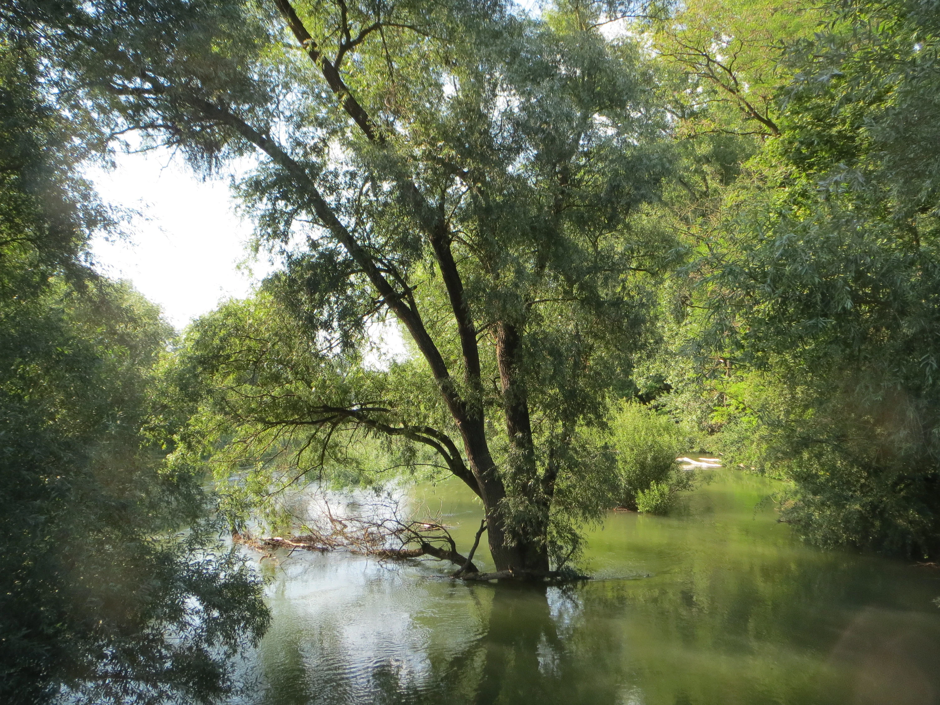
A large willow tree standing directly in calm floodwater in a densely vegetated riparian forest.
A white willow tree standing in floodwaters within the Rhine riparian forest of the Brückenkopf nature reserve.

Brückenkopf Nature Reserve history and protected-area timeline

Brückenkopf was formally designated as a nature reserve (Naturschutzgebiet) on 2 March 1982 under Rhineland-Palatinate conservation law, receiving the official designation NSG-7300-040. The protected status was assigned to preserve the area as a wetland habitat of biological and scientific importance, particularly because of the rare animal species and unusual plant communities documented there.

The reserve's name, however, originates in an older context. Brückenkopf refers to the site's role as part of the wider Germersheim fortification complex, a strategically important military position on the right bank of the Rhine. While the reserve itself is defined by ecological criteria, the persistence of the fortress-era name illustrates how military heritage and modern nature protection coexist in the cultural landscape of the Upper Rhine.

Brückenkopf Nature Reserve landscape and geographic character

Brückenkopf lies within the broad, flat Rhine floodplain landscape typical of the Upper Rhine Graben. To the west flows the Rhine itself, shaping the reserve's western boundary, while to the north the federal road B 35 passes through the broader floodplain corridor. The reserve is bordered on its eastern edges by the L 555 state road and the inter-state boundary with Baden-Württemberg, placing it in a transitional position between infrastructure corridors and natural floodplain habitat.

The terrain is low-lying and shaped by the Rhine's hydrological influence, with conditions favorable for water-retentive soils, marshy ground, and patchy wet woodland or reed vegetation. The relatively modest size of around 35 hectares means that the reserve is read less as an expansive wilderness than as an embedded fragment of floodplain habitat surrounded by roads, settlement areas, and the larger agricultural landscapes of the Germersheim district.

Brückenkopf Nature Reserve ecosystems, habitats, and plant life

The ecological character of Brückenkopf is defined above all by its wetland character, which supports a mosaic of wet meadow, reed, and aquatic habitats typical of the Upper Rhine floodplain. Such floodplain wetlands are unusually productive biotopes in central Europe, but they have also become fragmented and reduced through drainage, agriculture, and infrastructure development, which is why small protected remnants like Brückenkopf retain particular conservation significance.

The reserve is managed with explicit goals of maintaining habitat conditions for rare wetland species and preserving uncommon plant communities. Scientific interest in the site is part of the formal protection rationale, reflecting the value of these floodplain fragments as long-term monitoring sites for rare and specialist species along the Rhine.

Brückenkopf Nature Reserve wildlife and species highlights

Brückenkopf's wildlife profile reflects its character as a species-protection reserve for rare wetland and floodplain fauna. Among the documented species of particular conservation interest is the large water beetle Hydrous piceus (Pechschwarzer Kolbenwasserkäfer), an impressive aquatic beetle associated with undisturbed standing-water habitats. The presence of such species indicates that the reserve still maintains suitable open-water or reed-bed conditions despite its small size and its position near roads and settlement.

The reserve also supports Maculinea nausithous, the dusky large blue (Dunkler Wiesenknopf-Ameisenbläuling), a butterfly of European conservation concern whose life cycle depends on specific meadow host plants and host ants. Its occurrence in Brückenkopf highlights the importance of well-managed wet meadow habitat within the reserve. Together, these and other rare species make Brückenkopf a small but meaningful sanctuary for floodplain biodiversity in the Germersheim area.

Brückenkopf Nature Reserve conservation status and protection priorities

Brückenkopf is formally protected as a Naturschutzgebiet under Rhineland-Palatinate nature conservation law (NSG-7300-040) and is recorded in international databases such as the World Database on Protected Areas under WDPA ID 81468. It is classified as an IUCN Category IV area, indicating that its primary purpose is the managed conservation of particular habitats and species rather than the protection of an entire ecosystem or landscape.

The reserve's conservation value lies in the preservation of a functioning Rhine floodplain wetland that supports rare animal species and uncommon plant communities. By maintaining the hydrological and habitat conditions required by species such as Hydrous piceus, Maculinea nausithous, Inula salicina, and Peucedanum officinale, Brückenkopf contributes to broader efforts to sustain biodiversity along the heavily modified Upper Rhine. It sits within a wider cluster of protected floodplain and wetland sites in the Germersheim district, collectively forming a network of small reserves that safeguard key elements of the regional biodiversity.

Brückenkopf Nature Reserve cultural meaning and human context

The cultural context of Brückenkopf is closely tied to the military and political history of the Rhine frontier. The Germersheim fortress was historically one of the most important fortifications on the right bank of the Rhine, controlling a strategic crossing point. The term Brückenkopf, or bridgehead, evokes that defensive function, linking the modern nature reserve to a layered history of border defense, fortress engineering, and shifting national borders in the Upper Rhine region.

This military naming sits in interesting contrast to the reserve's contemporary purpose as a quiet sanctuary for wetland biodiversity. The landscape around Germersheim is rich in such overlapping layers of military, agricultural, and ecological history, and Brückenkopf is one of several sites in the district where remnants of the fortress era have become reinterpreted as protected natural areas.

Top sights and standout views in Brückenkopf Nature Reserve

Brückenkopf's strongest points of distinction are its combination of compact size, focused wetland species protection, and historically rooted name. The reserve conserves a small but ecologically valuable fragment of Upper Rhine floodplain habitat, which supports rare species such as Hydrous piceus and the dusky large blue butterfly, along with uncommon plants like Inula salicina and Peucedanum officinale.

Its placement directly along the Rhine, near the Baden-Württemberg border and within the city of Germersheim, makes it a useful example of how even very small reserves can play a meaningful role in regional biodiversity conservation in heavily modified floodplain landscapes.

Best time to visit Brückenkopf Nature Reserve

Because Brückenkopf is a small nature reserve rather than an open visitor attraction, visits are typically most rewarding in the warmer months when wetland plants are flowering and insect activity is at its peak. Late spring and summer are likely to be especially productive for observing the reserve's butterfly and aquatic invertebrate fauna, including species such as Maculinea nausithous. Wet meadows and floodplain vegetation generally take on their fullest ecological expression during this period, although visitors should keep in mind that the reserve's compact size and proximity to roads mean it is best treated as a quiet, focused nature visit rather than as a large-scale scenic destination.


Monthly climate preview

Long-term temperature and precipitation patterns across representative coordinates

Brückenkopf Climate Normals and Annual Weather by Month

Brückenkopf tracks measured monthly temperature and precipitation rhythms across a representative coordinate based on historical climate normals. Reviewing the full twelve-month profile provides deeper insight into long-term averages and environmental conditions.
Annual mean10 °C
1 °C21 °C
Jan
Feb
Mar
Apr10°
May15°
Jun19°
Jul21°
Aug20°
Sep16°
Oct10°
Nov
Dec
Warmest month
July

20.9 °C

Coolest month
January

0.6 °C

Wettest month
May

2.3 mm/day

Driest month
April

1.5 mm/day

Park location guide

Geography guide, regional context, and park location map for Brückenkopf Nature Reserve

Brückenkopf Nature Reserve park geography, regions, and map view in Germany

Understand where Brückenkopf Nature Reserve sits in Germany through a broader geographic reading of the surrounding landscape, nearby location context, and its mapped position within the national park landscape.

How Brückenkopf Nature Reserve fits into Germany

Germany is a federal republic in Western and Central Europe with a population of over 83 million across sixteen constituent states. It is Europe's largest economy by nominal GDP and a major global exporter and importer. The capital is Berlin, and the country borders Denmark, Poland, Czech Republic, Austria, Switzerland, France, Luxembourg, Belgium, and the Netherlands.

Wider geography shaping Brückenkopf Nature Reserve in Germany

Germany is located in Western and Central Europe, spanning 357,022 km². It borders Denmark to the north, Poland and the Czech Republic to the east, Austria and Switzerland to the south, and France, Luxembourg, Belgium, and the Netherlands to the west. The country has coastlines on the Baltic Sea and North Sea to the north, with the Alps located in the southern region.

Map view of Brückenkopf Nature Reserve

Use this park location map to pinpoint Brückenkopf Nature Reserve in Germany, understand its exact geographic position, and read its mapped placement within the surrounding landscape more clearly.

Pigeon | © OpenStreetMap contributors

Location context for Brückenkopf Nature Reserve

Rhineland-Palatinate

Explore detailed visual records of terrain, wet woodland habitats, and protected floodplain environments.

Brückenkopf Photos and Landscape Scenery: Visualizing the Rhine Floodplain Wetland Reserve

Visual documentation provides a clear look at the flat terrain, marshy ground, and specialized vegetation shaping this compact Rhine wetland reserve. Examining these protected area views helps reveal the ecological character and environmental setting of the Germersheim floodplain landscape.

A large willow tree standing directly in calm floodwater in a densely vegetated riparian forest.

Park atlas

Compare regional floodplain reserves and connected natural habitats across the Upper Rhine corridor

Explore Other Parks Near Brückenkopf and Surrounding Protected Wetland Landscapes

Browse protected areas near Brückenkopf to examine similar wetland habitats and floodplain ecosystems along the Rhine. Expanding the geographic scope helps connect individual reserves to broader regional conservation networks.
Watercolor painting of a tranquil wetland landscape with soft green vegetation and a calm water body, reflecting the floodplain environment of the Rhine river.
Nature reserveLandkreis Germersheim
About 2.7 km away#1 closest

South

Hördter Rheinaue Nature Reserve: Landscape and Geographic Context in Landkreis Germersheim

Examining the hydrology and floodplain forest of the German Rhine.

Hördter Rheinaue serves as a critical node in the Palatinate Rhine floodplains, preserving a vast mosaic of willow and poplar forests alongside stable hardwood stands. Analyze the mapped terrain shaped by centuries of river activity, including the meandering Michelsbach and associated oxbow systems that define this essential protected corridor in western Germany.

Area
8.18 km²
Established
1966
IUCN
IV
Relief
Lowland
A pale, atmospheric watercolor painting showing a quiet river scene with green trees and a hanging branch in the foreground, rendered in a light and airy style.
Nature reserveRhineland-Palatinate
About 3.4 km away#2 closest

North

Schwarzwald Nature Reserve: A Protected Rhine Floodplain Landscape in Rhineland-Palatinate

Geographic atlas of alluvial forests and oxbow river dynamics

Schwarzwald represents a significant nature reserve in Germany, characterized by its position between the modern Rhine and the Lingenfelder Altrhein. The area contains a rich collection of floodplain features, including alluvial forests, pollarded willows, and standing gravel pit lakes, offering a comprehensive look at the riparian geography of the Upper Rhine.

Area
3.41 km²
Established
1997
Nature reserveRhineland-Palatinate
About 7 km away#3 closest

West

Bellheimer Wald: Protected Alluvial Forest and Inland Dune Geography in Germany

Nature reserve landscapes in Rhineland-Palatinate

Bellheimer Wald offers a window into the unique geography of the Upper Rhine Plain. This protected forest is characterized by its sandy alluvial soils and rare inland dune systems, forming a core component of the alluvial-fan woodland chain that spans the southern Palatinate and supports complex habitats for specialized flora and fauna.

Area
46.79 km²
Established
2000
IUCN
IV
Relief
Lowland
Nature reserveRheinland-Pfalz
About 7.4 km away#4 closest

Northeast

Flotzgrün Nature Reserve: Protected Floodplain Landscapes and Rhine Geography in Rheinland-Pfalz

Mapping historical island creation and modern conservation polders

Flotzgrün serves as a compelling geographic entity within the Upper Rhine, functioning as both an active flood management polder and a protected riparian environment. This site offers insights into the intersection of 19th-century river straightening and modern ecological restoration, revealing a landscape defined by controlled wetlands, old river arms, and managed floodplain habitats.

Area
3.4 km²
Relief
Lowland
Scope
Terrestrial
Water
Major water bodies
A pale, minimalist watercolor painting showing a wide river flowing through a lush green floodplain with rolling hills in the background.
Nature reserveRhineland-Palatinate
About 9 km away#5 closest

Northeast

Speyerer Auwald Nature Reserve: Protected Alluvial Forest Geography in Rhineland-Palatinate

An essential Rhine valley floodplain and habitat mosaic

Located along the Upper Rhine, the Speyerer Auwald encompasses a vital protected landscape of alluvial forests, relic oxbows, and traditional meadows. This record traces the park boundaries, hydrological features, and the distinct ecological zones that make this floodplain forest a cornerstone of the regional geography in Rhineland-Palatinate.

Relief
Lowland
Climate
Temperate
Access
Easy access
Scope
Terrestrial
Soft watercolor painting of an oxbow lake landscape with green riverbanks, trees, and distant rolling hills against a pale sky.
Nature reserveRhineland-Palatinate
About 10 km away#6 closest

South

Leimersheimer Altrhein Nature Reserve: Mapped Geography and Protected Area Context

A preserved Rhine oxbow ecosystem in Rhineland-Palatinate

Leimersheimer Altrhein represents a rare, enduring fragment of the historical Rhine floodplain. This site hosts vital waterbird populations within an enclosed water landscape, providing essential habitat connectivity in a heavily regulated river region. Gain insights into the specific terrain, boundary configurations, and riparian mosaic that define this protected nature reserve.

Area
15 km²
Established
2004
IUCN
IV
A horizontal watercolor painting showing a stylized, soft-focus forest landscape with green trees against a pale, warm-toned ground.
Protected areaRhineland-Palatinate
About 11 km away#7 closest

Northwest

Speyerer Wald: Protected Alluvial Forest and Inland Sand Dune Landscape

Regional geography and protected area context in Rhineland-Palatinate.

Speyerer Wald offers a look into the formation of Rhine Plain alluvial fans and the survival of forest ecosystems on poor, sandy soils. This protected expanse showcases the intersection of inland dunes, dry sand grasslands, and riparian stream corridors. It serves as a key case study in regional landscape evolution, highlighting how ice age deposits continue to dictate current habitat distribution and nature conservation priorities.

Established
1981
Relief
Lowland
Climate
Temperate
Access
Easy access
A soft watercolor illustration of a rolling meadow landscape featuring green grasses and pink flowers against a light background.
Protected landscapeBaden-Württemberg
About 11 km away#8 closest

East

Hambrücker Wiesen Protected Landscape: A Geographical Atlas of Baden-Württemberg Terrain

Mapped meadows, wetland corridors, and regional landscape boundaries

Spanning 107 hectares in the Hardtebenen, Hambrücker Wiesen functions as a critical protected landscape in Baden-Württemberg. The area anchors a diverse geographic profile featuring lowland hay meadows, reed beds along the Wagbach, and open agricultural terrain. Discover how this site integrates into the broader network of protected zones within the Upper Rhine Plain while preserving its traditional rural character against development.

Area
1.066 km²
Established
1991
IUCN
V
Relief
Lowland

Common questions about visiting, size, designation, and location context for Brückenkopf Nature Reserve

Brückenkopf Nature Reserve FAQs for park facts, access, geography, and protected area context

Find quick answers about Brückenkopf Nature Reserve, including protected-area facts, park geography, trail and visitor context, and how the park fits into its surrounding country and regional landscape.
MoriAtlas Explorer

Continue Your Protected Areas Search Across the Global Atlas

Deepen your exploration by continuing the structured search for national parks and protected areas worldwide. Utilize the comprehensive filtering capabilities to compare different conservation landscapes and refine your understanding of global park geography. Discover more about the distribution and characteristics of protected natural areas.

Global natural geography