Mori Atlas logo
National parkBulabog Putian National Park

Understand the mapped boundaries and regional geographic context of this Philippine national park.

Bulabog Putian National Park: Philippines National Park Protected Landscape and Atlas Geography

Bulabog Putian National Park represents a key protected landscape within the Philippines, offering a distinct entry into the nation's atlas of natural areas. This page details the park's identity as a national park, providing essential geographic context and mapped information to support structured discovery and understanding of its place within the Philippine archipelago.

Limestone KarstBat CavesSecondary ForestMountain PeaksIUCN Category VWestern Visayas

Bulabog Putian National Park

National park

Park overview

Structured park overview, official facts, and landscape profile for Bulabog Putian National Park

Bulabog Putian National Park park facts, protected area profile, and essential visitor context
Review the core facts for Bulabog Putian National Park, including designation, size, terrain, visitor scale, habitats, and operating context in one park-focused overview.

About Bulabog Putian National Park

Bulabog Putian National Park occupies a distinctive place among Philippines protected areas as the sole limestone mountain formation in Iloilo province. The park straddles the municipalities of Dingle and San Enrique, covering barangays Morobaro, Lincud, Camambugan, Caguyuman, and Tulatulaan in Dingle, and Rumagayray, Campo, Palje, and Lip-ac in San Enrique. The central Bulabog Putian mountains contain Putian Peak at 322 meters, the highest elevation in Central Iloilo, which dominates the surrounding agricultural plains. The mountains derive their name from the prominent white stone wall on their northern face, visible from as far away as Passi City. Beyond the dramatic peaks, the park encompasses 13 caves, with Maestranza Cave serving as habitat for an estimated 20,000 fruit bats and Guiso Cave supporting 18 distinct bat species. The park also features Moroboro Spring, the eastern lake called Lake Bito, and a dam section of the Jalaur River. A 40-kilometer trail network traverses the rainforest, providing access to these diverse geological and ecological features.

Quick facts and research context for Bulabog Putian National Park

Bulabog Putian National Park covers 854.33 hectares in northern Iloilo, roughly 43 kilometers from Iloilo City. The park features the sole limestone mountain formation in Iloilo province, with Putian Peak reaching 322 meters as the highest point in Central Iloilo. The area contains 13 documented caves, including Maestranza Cave hosting an estimated 20,000 fruit bats and Guiso Cave with 18 bat species. The park encompasses Moroboro Spring, Lake Bito on its eastern side, and a dam along the Jalaur River. It was established on June 14, 1961 under IUCN Category V as a protected landscape and seascape.

Park context

Deeper park guide and search-rich context for Bulabog Putian National Park

Bulabog Putian National Park history, landscape, wildlife, and travel context
Explore Bulabog Putian National Park through its history, landscape character, ecosystems, wildlife, conservation priorities, cultural context, and seasonal travel timing in a structured park guide built for atlas discovery and search intent.

Why Bulabog Putian National Park stands out

The park is best known for its unique limestone karst landscape, which stands as the only such formation in Iloilo province. The dramatic white stone wall of Putian Peak serves as the park's most recognizable landmark. The extensive cave systems, particularly the bat colonies in Maestranza and Guiso caves, represent another major attraction. The historical significance of the Cry of Lincud, where the Philippine Revolution began in Iloilo in 1898, adds cultural depth to the natural landscape.

Bulabog Putian National Park history and protected-area timeline

The park was established on June 14, 1961 through Proclamation No. 760, signed by President Carlos P. Garcia. This designation placed the limestone mountain formation and surrounding rainforest under formal protection as a national park. The establishment reflected growing post-war recognition of the need to preserve distinctive geological formations and forest ecosystems in the Philippines. The park's historical significance predates its protected status, as the mountains served as the location of the Cry of Lincud in 1898, the event that initiated the Philippine Revolution in Iloilo province. This revolutionary context adds cultural importance to the natural landscape, linking the geological heritage of the formation to the broader historical narrative of Philippine independence.

Bulabog Putian National Park landscape and geographic character

The park's landscape is defined by its limestone karst mountains rising abruptly from the surrounding plains of Central Iloilo. Putian Peak at 322 meters represents the highest point in the region, a prominent geological landmark visible across considerable distances. The distinctive white stone wall on the mountain's northern face gives the formation its name and provides the most visually striking characteristic of the landscape. The terrain encompasses 13 caves of varying sizes, with the most significant including Maestranza Cave, Guiso Cave, and Lapuz Lapuz Cave. These cave systems have formed within the limestone substrate over geological time. The park also includes wetland features such as Lake Bito on its eastern boundary, springs including Moroboro Spring, and the modified course of the Jalaur River where a dam structure traverses the protected area.

Bulabog Putian National Park ecosystems, habitats, and plant life

The park supports a secondary growth forest ecosystem with diverse hardwood tree species. The forest contains commercially valuable trees including dao, molave, and narra, representing the native hardwood vegetation that has regenerated following historical disturbance. The limestone environment creates specialized habitats supporting distinct ecological communities. The cave systems represent particularly significant ecological features, with Maestranza Cave supporting an estimated colony of 20,000 fruit bats and Guiso Cave hosting 18 identified bat species. These bat populations play important roles in seed dispersal and insect control within the broader ecosystem. The forest also supports various bird species and other wildlife adapted to the limestone forest environment.

Bulabog Putian National Park wildlife and species highlights

The park supports diverse wildlife populations within its forest and cave ecosystems. Bird species present include the Philippine coucal, turtle doves, and green imperial pigeons. The reptile population includes various lizard species including iguanas. Primate species in the form of monkeys inhabit the forest canopy. The cave systems host significant bat populations with Maestranza Cave estimated to contain around 20,000 fruit bats while Guiso Cave shelters 18 different bat species. These colonial bat populations represent a notable wildlife feature, contributing to the park's ecological significance through their roles in pollination, seed dispersal, and insect population management.

Bulabog Putian National Park conservation status and protection priorities

Bulabog Putian National Park holds IUCN Category V status as a protected landscape and seascape, reflecting its role in preserving both natural and cultural values. The park protects the only limestone mountain formation in Iloilo province, representing a geologically significant landscape type in the region. The cave ecosystems with their substantial bat colonies contribute to biodiversity conservation, as these species rely on the protected cave habitats. The forest ecosystem, while secondary growth, maintains hardwood tree species including historically valuable木材 species. The 40-kilometer trail system provides sustainable access while limiting environmental impact. Conservation of this landscape also preserves the historical site associated with the Cry of Lincud, linking natural and cultural heritage protection.

Bulabog Putian National Park cultural meaning and human context

The park holds significant cultural importance as the location of the Cry of Lincud, a pivotal event in the Philippine Revolution. In 1898, revolutionary activities initiated in this area marked the beginning of organized resistance against Spanish colonial rule in Iloilo province. The mountains served as a strategic and symbolic location for this declaration, linking the natural landscape to foundational moments in regional and national history. The park encompasses areas associated with this historical narrative, including barangay Lincud which bears direct connection to the revolutionary event. This cultural dimension adds depth to the park's value beyond its geological and ecological significance, creating a place where natural heritage and historical memory converge.

Top sights and standout views in Bulabog Putian National Park

The limestone karst formation of Bulabog Putian stands as the park's most distinctive feature, the only such landscape in Iloilo province with Putian Peak dominating Central Iloilo at 322 meters. The white stone wall visible from Passi provides immediate visual recognition. The cave systems host remarkable bat colonies, particularly Maestranza Cave with its estimated 20,000 fruit bats representing one of the largest such colonies in the region. The park's historical significance as the site of the Cry of Lincud, where the Philippine Revolution began in Iloilo in 1898, adds cultural dimension not found in purely natural protected areas. The 40-kilometer trail network, Lake Bito, Moroboro Spring, and the Jalaur River dam create additional recreational and ecological features.

Best time to visit Bulabog Putian National Park

The park can be visited throughout the year given its location in the tropical Philippines. The dry season from November to April typically offers more comfortable conditions for hiking the trail network and exploring the cave systems. The wet season from May to October brings increased rainfall which can affect trail conditions and access but also enhances the lushness of the forest vegetation. Visitors interested in observing bat activity at the caves may find dawn and dusk observations most productive. The dry months generally provide more predictable conditions for outdoor exploration of the mountain trails and geological features.
Park location guide

Geography guide, regional context, and park location map for Bulabog Putian National Park

Bulabog Putian National Park park geography, regions, and map view in Philippines
Understand where Bulabog Putian National Park sits in Philippines through a broader geographic reading of the surrounding landscape, nearby location context, and its mapped position within the national park landscape.

How Bulabog Putian National Park fits into Philippines

The Philippines, officially the Republic of the Philippines, is an archipelagic nation in Southeast Asia comprising approximately 7,641 islands categorized into three main geographical divisions: Luzon, Visayas, and Mindanao. Located in the western Pacific Ocean, it shares maritime borders with Taiwan, Japan, Palau, Indonesia, Malaysia, Vietnam, and China. Manila serves as the capital city, while Quezon City is the most populated city, both within Metro Manila.

Wider geography shaping Bulabog Putian National Park in Philippines

The Philippines is an archipelagic nation in Southeast Asia, positioned in the western Pacific Ocean. Its islands are bounded by the South China Sea to the west, Philippine Sea to the east, and Celebes Sea to the south. The country shares maritime borders with Taiwan to the north, Japan to the northeast, Palau to the east and southeast, Indonesia to the south, Malaysia to the southwest, Vietnam to the west, and China to the northwest.

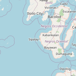
Map view of Bulabog Putian National Park

Use this park location map to pinpoint Bulabog Putian National Park in Philippines, understand its exact geographic position, and read its mapped placement within the surrounding landscape more clearly.

Pigeon | © OpenStreetMap contributors

Location context for Bulabog Putian National Park

IloiloWestern Visayas
Park atlas

Explore the regional context of protected areas beyond Bulabog Putian National Park, mapping other conservation landscapes in Western Visayas.

Explore Other National Parks and Protected Areas Near Bulabog Putian National Park
After exploring Bulabog Putian National Park's unique limestone karst landscape, browse a curated list of other national parks and protected areas across the Western Visayas region. Compare their distinct geographic features, conservation efforts, and regional importance, enhancing your understanding of protected landscapes in the Philippines.
National parkCebu

Guadalupe Mabugnao Mainit Hot Spring National Park: Protected Landscape and Watershed Geography

Explore hot springs, caves, and mapped terrain in Cebu.

Guadalupe Mabugnao Mainit Hot Spring National Park is a protected national park in Cebu, Philippines, recognized for its significant watershed function and unique natural features. Spanning forested highland terrain within the Mantalongon mountain range, the park protects natural hot springs, explored cave systems such as Cave Lorett, and river networks vital to local water supply. Its identity as a protected landscape offers rich opportunities for geographic exploration, mapping its boundaries, and understanding its role within the regional natural terrain and conservation efforts.

Area
0.575 km²
Established
1972
IUCN
V
Relief
Mountain
National parkPhilippines

Kuapnit Balinsasayao National Park: Philippines Old-Growth Forest and Endemic Wildlife Atlas

Explore protected landscape boundaries and mountainous terrain on Leyte Island.

Kuapnit Balinsasayao National Park stands as a key protected area within the Philippines, distinguished by its mature old-growth forests and its critical role in conserving endemic bird species unique to the Eastern Visayas. Located on Leyte Island within the mountainous terrain of the Anonang-Lobi Mountain Range, the park's protected landscape identity is central to understanding its geographic significance. This park offers a valuable entry point for exploring the mapped natural features and conservation importance of protected areas across the Philippine archipelago.

Area
3.64 km²
Established
1937
IUCN
V
Relief
Mountain
National parkPalo

MacArthur Landing Memorial National Park: Protected Area Geography & Map Context

Explore the mapped boundaries of this national park in Palo, Philippines.

This entry details MacArthur Landing Memorial National Park, a protected national park located near Palo, Philippines. It focuses on its identity as a mapped landscape and a distinct protected area, offering insights into its geographic context and atlas presence. Understanding this park involves exploring its mapped boundaries and its contribution to the regional protected area landscape, providing a factual basis for geographic discovery.

Area
0.068 km²
Established
1977
Relief
Lowland
Climate
Tropical
National parkPhilippines

Libmanan Caves National Park: Philippines National Park and Mapped Landscape

Explore protected area boundaries and regional geography.

Libmanan Caves National Park is a protected national park within the Philippines, offering a distinct focus for geographic discovery. This entry provides detailed context on its mapped landscape and its place within the archipelago's protected areas. Users can gain a clear understanding of the park's regional setting, facilitating atlas-style exploration and comprehension of its conservation significance within the Philippine geography.

Area
0.194 km²
Established
1934
IUCN
III
Relief
Upland
National parkLanao del Sur

Sacred Mountain National Park National Park: Detailed Geographic and Protected Landscape Context

Mapped boundaries and regional geography for Sacred Mountain National Park.

Sacred Mountain National Park, a significant national park in Lanao del Sur, offers a distinct protected landscape for atlas-driven discovery. This detailed entry provides insight into its geographic scope and mapped presence, allowing for a deeper understanding of its role within the region. Explore the specific natural terrain and protected area features that define Sacred Mountain National Park, grounded in factual geographic data.

Area
0.94 km²
Established
1965
IUCN
V
Relief
Mountain
National parkLaguna

Pagsanjan Gorge National Park: Philippines National Park & Protected Area Mapping

Explore the geographic context and mapped terrain.

Pagsanjan Gorge National Park represents a key protected natural area within the Laguna region, offering insights into Philippine national park geography. This entry focuses on understanding its mapped boundaries and the surrounding landscape context, providing a foundational element for anyone exploring protected lands through maps and regional atlases. It serves as a gateway to comprehending the park's specific geographic identity and its place within the natural environment of the Philippines.

Area
1.526 km²
Established
1939
IUCN
II
Relief
Upland
National parkLanao del Sur

Lake Butig National Park: National Park Atlas and Geographic Discovery in Lanao del Sur

Discover its mapped boundaries and regional landscape context.

Lake Butig National Park is a protected national park in the Philippines, located within Lanao del Sur. This entry provides specific geographic information and supports atlas exploration by detailing the park's mapped boundaries and its place within the regional landscape. Understand the terrain and protected area context crucial for geographic study and understanding Philippine natural landscapes.

Area
0.68 km²
Established
1965
IUCN
V
Relief
Mountain
National parkLanao del Sur

Pantuwaraya Lake National Park: National Park Atlas and Mapped Landscape

Explore the protected area and regional geography of Lanao del Sur.

Understand Pantuwaraya Lake National Park as a defined protected landscape and a significant national park within the Philippines. This entry focuses on its geographic placement in Lanao del Sur, providing context for its mapped boundaries and natural features. Users can explore its representation within a broader atlas of protected lands, gaining insight into its role and landscape identity.

Area
0.2 km²
Established
1965
IUCN
V
Climate
Tropical

Common questions about visiting, size, designation, and location context for Bulabog Putian National Park

Bulabog Putian National Park FAQs for park facts, access, geography, and protected area context
Find quick answers about Bulabog Putian National Park, including protected-area facts, park geography, trail and visitor context, and how the park fits into its surrounding country and regional landscape.
MoriAtlas Explorer

Continue Your Protected Areas Search Across the Global Atlas

Deepen your exploration by continuing the structured search for national parks and protected areas worldwide. Utilize the comprehensive filtering capabilities to compare different conservation landscapes and refine your understanding of global park geography. Discover more about the distribution and characteristics of protected natural areas.

Global natural geography