Mori Atlas logo
Nature reserveBurrinjuck Nature Reserve

A conservation-focused nature reserve showcasing inland eucalypt diversity and significant woodland habitats

Burrinjuck Nature Reserve: Mapped Protected Landscapes and Forested Terrain in New South Wales

Burrinjuck Nature Reserve spans more than 5,000 hectares of the south west slopes in New South Wales, protecting a mosaic of six unique eucalypt forest ecosystems. This significant conservation area supports a dense concentration of threatened woodland species and rare flora, including the crimson spider orchid and Grevillea iaspicula, within a terrain defined by ridges, valleys, and varied elevation. The reserve stands as a crucial inland catchment sanctuary where structured forest patches support exceptionally rich bird populations and distinct mammalian fauna.

strict nature reserveinland forestsouth west slopeseucalypt forestdry woodlandheath shrubland

Burrinjuck Nature Reserve

Nature reserve

Park overview

Structured park overview, official facts, and landscape profile for Burrinjuck Nature Reserve

Burrinjuck Nature Reserve park facts, protected area profile, and essential visitor context

Review the core facts for Burrinjuck Nature Reserve, including designation, size, terrain, visitor scale, habitats, and operating context in one park-focused overview.

About Burrinjuck Nature Reserve

Burrinjuck Nature Reserve is a protected inland reserve in southern New South Wales that exemplifies the ecological richness of the state's south west slopes. Although it covers roughly 5,250 hectares rather than the vast tracts typical of larger Australian national parks, it concentrates an extraordinary variety of vegetation within that footprint. The reserve spans gentle sloping country, steeper hillsides, and ridges, and includes patches of dry grassy woodland, heathy low woodland, moist forest, and tall eucalypt forest. Together, these habitats form a compact but ecologically meaningful sample of the inland forests that once covered much of southern New South Wales.

The reserve was gazetted in 1984 and has been managed since then by the NSW National Parks and Wildlife Service as a strict nature reserve, a designation that prioritizes ecological preservation over recreation and infrastructure development. Its setting near the well-known Burrinjuck Dam and the adjacent Burrinjuck Waters State Park gives the area a regional identity connected to water, hydroelectric infrastructure, and rural tourism, but Burrinjuck Nature Reserve itself sits apart from those more heavily used spaces, functioning primarily as a refuge for native flora and fauna.

Visitors who travel through the reserve typically do so on foot via the Hume and Hovell Track, one of Australia's historic long-distance walking routes, or via a walking track that climbs to the summit of Mount Barren Jack, which looks out over the surrounding forested catchment. These limited public facilities reflect the reserve's strict management approach. The reserve is not designed for dense recreation use; instead, its infrastructure is minimal, its access is constrained, and most of its value lies in what it protects rather than what it offers as a tourism amenity.

In conservation terms, Burrinjuck stands out for the disproportionate number of threatened species it maintains within a relatively limited forest area. A small population of the endangered crimson spider orchid grows here, vulnerable woodland plants such as the Yass daisy persist in its grassy understoreys, and sub-populations of Grevillea iaspicula occur within its boundaries. Together with a rich bird list of more than 170 species and sixteen animal species listed as vulnerable under New South Wales threatened species legislation, this concentration of rare and declining biota gives the reserve an outsized importance for biodiversity conservation in inland southern New South Wales.

Quick facts and research context for Burrinjuck Nature Reserve

Burrinjuck Nature Reserve was formally established in 1984, when an initial block of around 1,286 hectares was protected and later expanded to its current extent of approximately 5,250 hectares. It lies on the south west slopes of New South Wales, near the locality of Burrinjuck, and is administered by the NSW National Parks and Wildlife Service under an IUCN Category Ia strict nature reserve designation.

The reserve contains six recognized forest ecosystems dominated by eucalypts, with Norton's box, red stringybark, brittle gum, broad-leaved peppermint, and southern blue gum among the most characteristic canopy species. It supports one of only a handful of known populations of the endangered crimson spider orchid, and it also harbors plants such as the Yass daisy (vulnerable) and Grevillea iaspicula, which meets the criteria for critically endangered listing in New South Wales. Sixteen animal species recorded in the reserve are listed as vulnerable under the state's threatened species legislation.

Protection and recognition

Examine documented protection scope, management assignments, and recognition sources for Burrinjuck Nature Reserve.

Burrinjuck Nature Reserve Protection Status and Terrestrial Conservation Scope

Burrinjuck Nature Reserve maintains a documented terrestrial protection scope within its designated conservation framework. Structured records outline the official protection status and administrative parameters associated with the protected area.

Protection details

Protection scope
Terrestrial
Transboundary protection
No
Park context

Deeper park guide and search-rich context for Burrinjuck Nature Reserve

Burrinjuck Nature Reserve history, landscape, wildlife, and travel context

Explore Burrinjuck Nature Reserve through its history, landscape character, ecosystems, wildlife, conservation priorities, cultural context, and seasonal travel timing in a structured park guide built for atlas discovery and search intent.

Why Burrinjuck Nature Reserve stands out

Burrinjuck is best known for the unusually high diversity of eucalypt-dominated forest types packed into a relatively small inland reserve. Six distinct forest ecosystems occur across its slopes and ridges, ranging from apple box and Norton's box moist grass forests on the eastern side to blue gum and broad-leaved peppermint shrub forests on the gentle central slopes and brittle gum peppermint forests on the steeper southern hills. The reserve is also widely recognized for its role in protecting rare and threatened plant populations, particularly the crimson spider orchid, of which around 100 plants grow here as one of only four known New South Wales populations, and Grevillea iaspicula, which meets the criteria for critically endangered listing. It is similarly notable for its birdlife, with close to 180 recorded species and a particularly strong representation of vulnerable woodland birds such as the superb parrot, turquoise parrot, and gang-gang cockatoo.
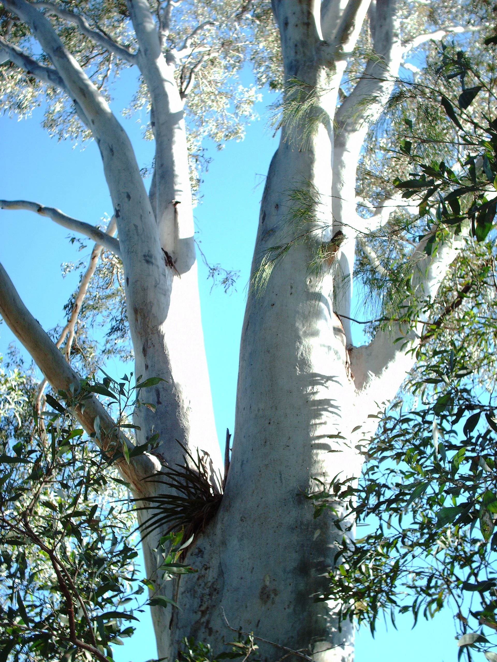
Close-up view of the smooth, pale, mottled bark of a mature blue gum tree reaching toward a clear blue sky.
A mature blue gum tree, a signature species within Burrinjuck Nature Reserve.

Burrinjuck Nature Reserve history and protected-area timeline

Burrinjuck Nature Reserve was formally established in 1984 following a process that began with the protection of an initial core area of around 1,286 hectares. After that initial designation, the reserve was progressively expanded in stages through additional land acquisitions and additions, eventually reaching its present extent of roughly 5,250 hectares. The reserve was created to protect a representative sample of the forested south west slopes country of inland New South Wales, at a time when many of these woodland and forest types were already being reduced or modified through clearing, grazing, and forestry.

The landscape within the reserve has been repeatedly shaped by fire. The entire reserve has been subject to bushfire at some stage, although the severity and frequency of burning has varied across different parts of the forest. A particularly significant fire event occurred during the summer of 1972 and 1973, before the reserve was formally gazetted, when an intense blaze burned an estimated 16,000 hectares of the broader local landscape. These fire histories continue to influence the vegetation communities found in the reserve today, particularly the grassy and heathy understorey layers.

Public access and use of the reserve have always been deliberately limited, in keeping with its designation as a strict nature reserve. The main public infrastructure consists of a section of the Hume and Hovell Track, a historic inland walking route that runs through the reserve, and a track leading to the summit of Mount Barren Jack, which provides one of the more defined walking experiences in the area. This minimal development reflects the reserve's management intent of prioritizing ecological protection over recreational infrastructure.

Burrinjuck Nature Reserve landscape and geographic character

Burrinjuck Nature Reserve lies within the gently undulating to steeply sloping country of the south west slopes of New South Wales, an inland region characterized by ridges, valleys, and forested catchments rather than the dramatic mountain peaks found further east. The reserve's topography varies from gentler slopes in its central zones to noticeably steeper terrain on the southern and western edges, producing a mosaic of landforms that supports its varied vegetation.

The summit of Mount Barren Jack provides a focal point within the reserve and offers expansive views out over the surrounding forested landscape and toward the broader Burrinjuck catchment. In the centre of the reserve, gentle slopes support a matrix of dry grassy shrub forests, while the eastern portions are dominated by a plateau-like expanse of moist eucalypt forest. Toward the south and west, steeper hillsides carry different combinations of eucalypt species and a higher proportion of heathy shrub elements, giving these parts of the reserve a structurally different appearance.

The reserve sits within the broader landscape associated with Burrinjuck Dam and the surrounding waterways, and although its boundaries are forested rather than lakeside, its catchment context shapes both its ecological conditions and its role in protecting water values for the region. The interplay of slope, aspect, and soils across the reserve is one of the main reasons such a wide range of forest types is able to coexist within a relatively small area.

Burrinjuck Nature Reserve ecosystems, habitats, and plant life

The ecological heart of Burrinjuck Nature Reserve lies in its remarkable concentration of six distinct forest ecosystems within a small area. These ecosystems range from moist grass forests dominated by apple box and Norton's box on the eastern side, to steep-slope forests of Norton's box and snow grass in the south west, to forests on the steeper southern hills dominated by brittle gum and broad-leaved peppermint. Heath shrub forests, heathy low open woodlands, and dry grass shrub forests make up the remaining ecosystem types, each with its own characteristic mix of eucalypts, wattles, pea-flowers, and native grasses.

Common canopy trees across the reserve include southern blue gum, red stringybark, Robertson's peppermint, long-leaved box, brittle gum, and inland scribbly gum, while black cypress pine features prominently in the heathy woodland at the northern edge of the reserve. The understorey is rich and varied, with silver wattle, shiny cassinia, varnish wattle, hoary guinea flower, twyning glycine, native geranium, and numerous native grasses such as snow grass, weeping grass, and silvertop wallaby grass. This diversity of structural layers and species creates a complex mosaic of habitat types across the reserve.

Habitats within the reserve include woodland, dry forest, moist forest, heathland, and grassy slope environments, and these collectively support an unusually high diversity of fauna for an inland reserve of this size. The botanical richness is also expressed in a number of rare and threatened plants, including the Yass daisy, the crimson spider orchid, and populations of Grevillea iaspicula, which together give the reserve significant value for conservation of New South Wales' inland flora.

Burrinjuck Nature Reserve wildlife and species highlights

Burrinjuck Nature Reserve supports a rich and varied fauna shaped by its diverse vegetation. Since the late 1970s, surveys have recorded three amphibian species, nine reptile species, 32 mammal species, and 179 bird species within the reserve. This high species count reflects the breadth of habitat types and the reserve's location at an inland ecological crossroads where multiple woodland and forest environments meet.

The reserve is particularly notable for its birdlife. Among the species recorded there, sixteen are listed as vulnerable under New South Wales threatened species legislation, including the gang-gang cockatoo, turquoise parrot, superb parrot, barking owl, powerful owl, brown treecreeper, speckled warbler, black-chinned honeyeater, hooded robin, grey-crowned babbler, olive whistler, and diamond firetail. These woodland-dependent species give the reserve a strong profile as habitat for declining inland and forest-edge birds, many of which face ongoing pressure from habitat loss elsewhere in the region.

Mammal diversity is also significant, with arboreal and ground-dwelling species both represented. Notable threatened mammals include the spotted-tailed quoll, yellow-bellied glider, squirrel glider, and eastern bent-wing bat, all of which are listed as vulnerable. The presence of multiple gliding possums alongside marsupial predators and cave-roosting bats indicates that the reserve retains not only tree cover but also older hollow-bearing trees and roosting sites that are essential to these species.

Burrinjuck Nature Reserve conservation status and protection priorities

Burrinjuck Nature Reserve plays an important conservation role as one of the key refuges for woodland and dry forest biodiversity on the south west slopes of New South Wales. Its strict nature reserve designation under IUCN Category Ia signals a management intent focused on ecological integrity rather than recreation, and its protected status helps shield a representative sample of inland forest ecosystems from ongoing pressures such as clearing, grazing, and inappropriate fire regimes.

The reserve's conservation importance is strongly reinforced by the number of threatened species it supports. Two plant species listed under the New South Wales Threatened Species Conservation Act 1995 are known to occur within the reserve, including the endangered crimson spider orchid, of which approximately 100 plants grow in one of only four known New South Wales populations, and the vulnerable Yass daisy. A further plant species, Grevillea iaspicula, meets the criteria for critically endangered listing, and one of its seven known Wee Jasper to Burrinjuck sub-populations falls within the reserve. Sixteen animal species recorded in the reserve are also listed as vulnerable, giving the reserve a meaningful role in maintaining populations of declining woodland birds, gliders, and bats.

Beyond its direct protection of habitat, the reserve contributes to broader landscape connectivity in the Burrinjuck and Wee Jasper region, where adjoining protected lands, forested catchments, and the waters of Burrinjuck Dam form an integrated natural landscape. Its fire history, including a significant 1972 to 1973 fire event that burned roughly 16,000 hectares across the broader area, has also shaped ongoing thinking about fire management and the resilience of the forest communities the reserve protects.

Burrinjuck Nature Reserve cultural meaning and human context

The cultural context of Burrinjuck Nature Reserve is closely bound up with the broader Burrinjuck landscape, which is dominated by Burrinjuck Dam and the surrounding forested catchment. The reserve sits adjacent to Burrinjuck Waters State Park, a recreation-focused counterpart where most public facilities in the broader area are concentrated, and it shares its regional identity with the inland water and power infrastructure that has shaped settlement patterns and tourism in southern New South Wales.

A defining cultural thread running through the reserve is the Hume and Hovell Track, a historic inland walking route that commemorates the early nineteenth century exploration of the region by Hamilton Hume and William Hovell. The track's passage through the reserve connects visitors to the broader story of inland exploration and pastoral expansion in New South Wales, while also framing the reserve as part of a wider network of cultural and recreational routes in inland Australia.

The reserve itself has been managed to keep public infrastructure minimal, with only the walking track to the summit of Mount Barren Jack and the section of the Hume and Hovell Track available to visitors. This restrained approach reflects both the reserve's strict nature reserve status and an effort to protect the cultural and natural values of the landscape from the impacts of heavier recreational use.

Top sights and standout views in Burrinjuck Nature Reserve

Burrinjuck Nature Reserve stands out for six distinct forest ecosystems in a single inland reserve, including blue gum peppermint shrub forests, brittle gum peppermint forests, and heathy woodlands dominated by black cypress pine. The reserve's bird list of 179 species is exceptionally rich for its size, and its mammal fauna includes significant populations of gliding possums and a resident spotted-tailed quoll population.

More distinctive still is the reserve's role in protecting rare plants. The crimson spider orchid occurs here in one of only four known New South Wales populations, with about 100 plants growing within the reserve, and Grevillea iaspicula, which meets the threshold for critically endangered listing, also has a sub-population within the reserve's boundaries.

Best time to visit Burrinjuck Nature Reserve

Spring and early summer are typically the most rewarding periods to experience Burrinjuck Nature Reserve, when native wildflower displays are at their peak across the grassy and heathy woodland understoreys, orchids such as the crimson spider orchid are more likely to be in flower, and the eucalypt forests are in active growth following winter rainfall. Early morning visits during these seasons also tend to provide the most rewarding birdwatching, as the rich bird list of the reserve is most active in cooler parts of the day.

Autumn offers a contrasting experience, with cooler temperatures, often clearer skies, and excellent conditions for longer walks including a traverse of the summit of Mount Barren Jack. Winter can be colder and quieter, with shorter daylight hours, and summers in inland New South Wales can be hot and carry elevated bushfire risk, particularly given the reserve's history of significant fire events. Visitors in any season should be conscious of changing fire conditions and seasonal track accessibility.


Monthly climate preview

Examine long-term representative temperature ranges and monthly precipitation rhythm for Burrinjuck Nature Reserve

Burrinjuck Nature Reserve Climate Normals and Annual Weather Patterns

Long-term data records for Burrinjuck Nature Reserve outline a distinct annual temperature progression alongside steady monthly precipitation averages measured at a representative elevation coordinate. Detailed month-by-month analysis profiles provide complete historical climatology statistics for deep geographic study.
Annual mean14 °C
6 °C22 °C
Jan22°
Feb21°
Mar18°
Apr14°
May10°
Jun
Jul
Aug
Sep10°
Oct13°
Nov17°
Dec20°
Warmest month
January

22.4 °C

Coolest month
July

5.7 °C

Wettest month
November

2.3 mm/day

Driest month
April

1.1 mm/day

Park location guide

Geography guide, regional context, and park location map for Burrinjuck Nature Reserve

Burrinjuck Nature Reserve park geography, regions, and map view in Australia

Understand where Burrinjuck Nature Reserve sits in Australia through a broader geographic reading of the surrounding landscape, nearby location context, and its mapped position within the national park landscape.

How Burrinjuck Nature Reserve fits into Australia

Australia is a constitutional monarchy and federal parliamentary democracy comprising six states and ten territories. With a population of nearly 28 million, it is one of the world's most urbanised countries, with most people concentrated on the eastern seaboard. The country has a high Human Development Index and is known for its cultural diversity, ancient Aboriginal heritage, and unique wildlife.

Wider geography shaping Burrinjuck Nature Reserve in Australia

Australia occupies the entire Australian continent, the island of Tasmania, and numerous smaller islands. It is the world's flattest and driest inhabited continent, featuring vast deserts in the interior (the Outback), tropical rainforests along the eastern coast, and a coastline bordering the Indian and Pacific Oceans.

Map view of Burrinjuck Nature Reserve

Use this park location map to pinpoint Burrinjuck Nature Reserve in Australia, understand its exact geographic position, and read its mapped placement within the surrounding landscape more clearly.

Pigeon | © OpenStreetMap contributors

Location context for Burrinjuck Nature Reserve

New South Wales

Visual reference for eucalypt ecosystems, slopes, and protected habitats

Burrinjuck Nature Reserve Photos, Scenery, and Protected Forest Landscapes

Visual documentation reveals the diverse forest ecosystems and rugged terrain defining Burrinjuck Nature Reserve. Field photography provides clear context on eucalypt woodlands, steep southern ridges, and protected catchment habitats.

Close-up view of the smooth, pale, mottled bark of a mature blue gum tree reaching toward a clear blue sky.

Park atlas

Compare nearby reserves, regional catchments, and connected eucalypt forests across the southern slopes.

Parks Near Burrinjuck Nature Reserve and Surrounding Protected Landscapes

Browsing parks near Burrinjuck Nature Reserve reveals a rich network of protected forests and catchment reserves across New South Wales. Examining adjacent landscapes provides deeper geographic context into the regional spread of eucalypt woodlands and vulnerable wildlife habitats.
Nature reserveNew South Wales
About 9.5 km away#1 closest

South

Black Andrew Nature Reserve: Protected Landscape and Geographic Mapping in New South Wales

Strict conservation habitat within the Murrumbidgee River catchment

Black Andrew Nature Reserve features an intricate landscape of undulating slopes and riparian gullies on the south west slopes of New South Wales. The reserve is notable for its high botanical richness, with seven distinct vegetation communities mapped across substrates that range from granite to basalt. This protected area provides essential habitat for multiple threatened species while maintaining vital forest connectivity along the Burrinjuck Dam shoreline.

Area
15.59 km²
Established
2001
IUCN
Ia
Relief
Upland
Nature reserveNew South Wales
About 14 km away#2 closest

Southeast

Oak Creek Nature Reserve: Regional Forest Conservation and Geographic Mapping

Strictly protected eucalypt forest in the Southern Tablelands

Oak Creek Nature Reserve represents an ecologically focused protected area within southeastern Australia. Spanning roughly 400 hectares of forest and woodland, this nature reserve illustrates the critical role of small, strictly managed sites in maintaining habitat connectivity across the diverse topography of the New South Wales Southern Tablelands region.

Area
4.04 km²
Established
2001
IUCN
Ia
Scope
Terrestrial
Nature reserveNew South Wales
About 15 km away#3 closest

South

Wee Jasper Nature Reserve: Protected Woodland Geography and Ecological Mapping in New South Wales

Explore the forest terrain and conservation landscape of this Southern Tablelands reserve.

Wee Jasper Nature Reserve provides a focused look at how slope aspect and drainage shape forest plant communities. Located near the Goodradigbee River corridor in New South Wales, this reserve protects a high concentration of rare flora within a compact, strictly managed geographic boundary.

Area
6.3 km²
Established
1979
IUCN
Ia
Relief
Upland
National parkNew South Wales
About 24 km away#4 closest

Southeast

Brindabella National Park: A Protected Mountain Landscape in New South Wales' Australian Alps

Discover its mapped terrain and regional geographic context.

Brindabella National Park offers a unique perspective on the mountainous terrain of the Brindabella Range, forming a vital protected area within the Australian Alps. Located in New South Wales, its landscape features rugged ridgelines and diverse subalpine vegetation, recognized for its national environmental significance. This park serves as a key destination for understanding protected area geography and the mapped context of Australia's high country.

Area
184.54 km²
Established
1996
IUCN
II
Relief
Mountain
Watercolor painting showing mountains, fields, and a river
National parkNew South Wales
About 43 km away#5 closest

South

Kosciuszko National Park: Australia's Highest Alpine Terrain and Mapped Protected Landscape

Discover unique glacial landscapes and geographic context in New South Wales.

Kosciuszko National Park represents the pinnacle of Australia's alpine geography, preserving the continent's only true alpine ecosystems. This extensive national park in New South Wales features dramatic glacial landforms, including its namesake Mount Kosciuszko, Australia's highest peak. Users can explore the park's mapped boundaries, surrounding natural terrain, and unique landscape features for a comprehensive understanding of this significant protected area.

Area
6,900 km²
Established
1944
IUCN
II
Visitors
3.3M annual
National parkAustralian Capital Territory
About 43 km away#6 closest

Southeast

Namadgi National Park: Protected Landscape and Geographic Context in Australian Capital Territory

Explore the mapped boundaries and regional geography of this national park.

Namadgi National Park is a designated national park situated in the Australian Capital Territory. This dedicated page offers detailed information on its protected status, geographic features, and its role within the regional landscape atlas of Australia. Dive into the mapped terrain and understand the park's environmental significance and its contribution to the conservation landscape of the Australian Capital Territory.

Area
1,060.95 km²
Established
1984
IUCN
II
Relief
Mountain
A soft watercolor illustration of a grassy woodland landscape with scattered trees, rolling hills in the background, and a small meandering creek in the foreground.
Nature reserveAustralian Capital Territory
About 55 km away#7 closest

Southeast

Mulligans Flat Woodland Sanctuary: A Detailed Geographic and Protected Landscape Overview

Ecological restoration and woodland geography in the Australian Capital Territory

Mulligans Flat Woodland Sanctuary operates as a fenced nature reserve in northern Canberra, protecting expansive grassy woodland habitats and native ecosystems. The site provides a unique look at temperate woodland recovery, featuring a diverse mix of remnant eucalypt forests, seasonal wetlands, and volcanic terrain that serves as a key component of regional ecological connectivity.

Area
12.53 km²
Established
1994
IUCN
IV
Relief
Upland
Marine protected areaAustralia
About 63 km away#8 closest

Southeast

Australian Whale Sanctuary: Mapping the Scale of Australia's Marine Protected Area Jurisdictions

Oceanic landscape, maritime boundaries, and cetacean conservation zones.

Discover the expansive geographic reach of the Australian Whale Sanctuary, an oceanic conservation zone that encompasses the entire Australian exclusive economic zone. This protected landscape is defined by its immense scale, stretching across varied marine environments to provide a continuous refuge for whales and dolphins. Gain perspective on the sanctuary's role as both a legal framework and a massive, interconnected maritime atlas.

Established
1999
Access
Access unknown
Scope
Marine
Water
Water-dominated

Common questions about visiting, size, designation, and location context for Burrinjuck Nature Reserve

Burrinjuck Nature Reserve FAQs for park facts, access, geography, and protected area context

Find quick answers about Burrinjuck Nature Reserve, including protected-area facts, park geography, trail and visitor context, and how the park fits into its surrounding country and regional landscape.
MoriAtlas Explorer

Continue Your Protected Areas Search Across the Global Atlas

Deepen your exploration by continuing the structured search for national parks and protected areas worldwide. Utilize the comprehensive filtering capabilities to compare different conservation landscapes and refine your understanding of global park geography. Discover more about the distribution and characteristics of protected natural areas.

Global natural geography