

Mori Atlas logo
Wildlife reserveCabadbaran-Santiago Watershed Forest Reserve

Mapping the forested headwaters and mountainous terrain of the Diwata range ecosystem

Cabadbaran-Santiago Watershed Forest Reserve: A Protected Upland Landscape in Agusan del Norte

Cabadbaran-Santiago Watershed Forest Reserve encompasses over 16,000 hectares of vital tropical mountain terrain on the northern flanks of Mount Hilong-hilong. As a core protected area within the Diwata range of Agusan del Norte, the reserve functions as an essential water catchment system for surrounding municipalities. Its geography spans from lowland elevations to rugged montane forests, providing significant habitat for diverse endemic wildlife and maintaining the integrity of major river headwaters.

watershed reservetropical forestupland catchmentMindanao forestsDiwata rangeMount Hilong-hilong foothills

Cabadbaran-Santiago Watershed Forest Reserve

Wildlife reserve

Park overview

Structured park overview, official facts, and landscape profile for Cabadbaran-Santiago Watershed Forest Reserve

Cabadbaran-Santiago Watershed Forest Reserve park facts, protected area profile, and essential visitor context

Review the core facts for Cabadbaran-Santiago Watershed Forest Reserve, including designation, size, terrain, visitor scale, habitats, and operating context in one park-focused overview.

About Cabadbaran-Santiago Watershed Forest Reserve

Cabadbaran-Santiago Watershed Forest Reserve is one of the key upland protected areas of northeastern Mindanao, anchoring the forested upper slopes of the Diwata Mountain range where the provinces of Agusan del Norte, Agusan del Sur, and Surigao del Sur meet. Although it is often overlooked compared to the more famous national parks and seascapes of the southern Philippines, the reserve plays a foundational role in regional hydrology by safeguarding the forested catchments that feed the rivers and streams supplying nearby communities.

The reserve's elevation span is one of its most defining physical traits, rising from lowlands at around 200 meters above sea level to mid-mountain elevations approaching 1,700 meters along the flanks of Mount Hilong-hilong. This vertical range produces a layering of habitats from lowland forest communities, through transitional zones of mixed tree cover, into cooler mid-elevation forest types. The forest remains the dominant land cover, giving way in patches to shrubby areas with low trees and limited open grassland. Within the forested extent, managed rattan palm plantations occupy a small but notable portion, reflecting a pattern of regulated use rather than strict preservation in this particular reserve.

Watershed function is the heart of the reserve's identity. The protected area captures the headwaters of the Cabadbaran River and the Narog River, as well as a network of smaller streams such as Tumipi, Pamulanganan, Saypon, Damasigan, Subayon, Sigupanon, Kalupsagan, Landulan, Kalasonon, Dacnalay, and Hamindangan. These waterways ultimately feed the broader Agusan drainage system, which supports both rural livelihoods and urban water demand in the region. The protection of these headwaters, combined with the persistence of contiguous forest cover, gives the reserve its practical and ecological value.

From a biodiversity standpoint, the reserve contributes to the integrity of one of Mindanao's more important forest blocks. Its elevation range and relative inaccessibility have allowed populations of native mammals, forest birds, reptiles, and freshwater species to persist. As part of the Caraga region's protected-area network, Cabadbaran-Santiago provides a crucial terrestrial counterpoint to the more frequently visited coastal and wetland reserves of the area, including Agusan Marsh, the Andanan Watershed, and the Siargao and Mahaba Island seascapes.

Quick facts and research context for Cabadbaran-Santiago Watershed Forest Reserve

Cabadbaran-Santiago Watershed Forest Reserve is situated on northeastern Mindanao in the Philippines and forms part of the protected-area network of the Caraga administrative region. The reserve overlaps three provinces, Agusan del Norte, Agusan del Sur, and Surigao del Sur, and lies adjacent to Cabadbaran City, the nearest urban center.

It covers approximately 160.25 square kilometers of terrain ranging from roughly 200 meters to about 1,700 meters above sea level, encompassing the lower flanks and mid-elevation slopes of the Diwata range on the northern side of Mount Hilong-hilong. Designated in 1991, the reserve exists primarily to protect upland forests and the rivers that originate within them, including the Cabadbaran and Narog rivers along with numerous smaller tributaries.

Protection and recognition

Documented terrestrial protection scope, designation history, and international registry records

Cabadbaran-Santiago Watershed Forest Reserve Protection Status and Recognition

Cabadbaran-Santiago Watershed Forest Reserve maintains a documented terrestrial protection scope within official conservation databases. Protected area records outline the baseline designation framework and international recognition data associated with this reserve.

Protection details

Protection scope
Terrestrial
Transboundary protection
No
WDPA ID
306541
Park context

Deeper park guide and search-rich context for Cabadbaran-Santiago Watershed Forest Reserve

Cabadbaran-Santiago Watershed Forest Reserve history, landscape, wildlife, and travel context

Explore Cabadbaran-Santiago Watershed Forest Reserve through its history, landscape character, ecosystems, wildlife, conservation priorities, cultural context, and seasonal travel timing in a structured park guide built for atlas discovery and search intent.

Why Cabadbaran-Santiago Watershed Forest Reserve stands out

The reserve is best known as the principal watershed supplying freshwater to the municipalities of Cabadbaran and Santiago, and as a forested stronghold on the northern slopes of Mount Hilong-hilong within the Diwata range. It is recognized for its mosaic of closed-canopy forest, scattered rattan plantations, shrubland, and grassland, as well as for the headwater streams that drain into the broader Agusan drainage system. It also carries conservation importance as habitat for Mindanao's native forest wildlife, including the Philippine deer, wild pigs, macaques, and several bird species of conservation interest. BirdLife International has historically designated the broader Mount Hilong-hilong area, which includes this reserve, as an Important Bird Area, reflecting its role in supporting forest and raptor populations in northeastern Mindanao.

Cabadbaran-Santiago Watershed Forest Reserve history and protected-area timeline

The Cabadbaran-Santiago Watershed Forest Reserve was formally established on November 13, 1991, by Presidential Proclamation No. 834 of the Republic of the Philippines. The proclamation recognized the area's role as a vital water catchment for the lowland municipalities of Cabadbaran and Santiago in Agusan del Norte, and placed its roughly 16,000 hectares of forested upper watershed under state protection.

The designation came during a period in which the Philippine government sought to formalize protection for many of Mindanao's remaining forest watersheds, many of which were under mounting pressure from logging, slash-and-burn agriculture, and resettlement. By setting aside the upper Diwata range as a watershed reserve rather than a stricter national park, the proclamation allowed for regulated uses such as small-scale rattan cultivation and limited agricultural activity, while still aiming to maintain forest cover and river flow. The reserve has since been recognized in regional and international databases, including the World Database on Protected Areas, and its broader landscape context, the Mount Hilong-hilong area, has been identified by BirdLife International as a site of notable conservation value.

Cabadbaran-Santiago Watershed Forest Reserve landscape and geographic character

The landscape of the reserve is dominated by mountainous terrain associated with the Diwata range, particularly the northern flanks of Mount Hilong-hilong, one of the prominent high points of northeastern Mindanao. Elevations within the reserve rise from around 200 meters in the lower transition zones to roughly 1,700 meters along the upper slopes, producing a layered topography of ridges, valleys, and steep forested hillsides.

The reserve's drainage network is a defining element of its scenery. The Cabadbaran and Narog rivers carve the main valleys, while numerous smaller tributaries, including Tumipi, Pamulanganan, Saypon, Damasigan, Subayon, Sigupanon, Kalupsagan, Landulan, Kalasonon, Dacnalay, and Hamindangan, descend through forested ravines and gorges. These streams form cascades, small waterfalls, and boulder-strewn channels typical of humid tropical mountain terrain.

Below the closed forests, the reserve transitions into mosaics of secondary shrubland, low-stature woodland, narrow grassland openings, and patches of cultivated land where cereals and fast-growing timber species such as Gmelina arborea are grown. These more open and modified areas are concentrated along the lower elevations and in accessible valley margins, while the steepest and highest sections tend to retain denser forest cover. The result is a landscape pattern in which vigorous, well-watered forest dominates the visual impression, but with visible evidence of human land use in the lower reaches.

Cabadbaran-Santiago Watershed Forest Reserve ecosystems, habitats, and plant life

Ecologically, Cabadbaran-Santiago Watershed Forest Reserve represents a substantial block of tropical lowland and mid-elevation forest on northeastern Mindanao. Its elevation gradient, combined with persistent forest cover, supports habitat diversity that ranges from lowland dipterocarp communities in the lower zones to more montane-influenced forest types at higher elevations.

The vegetation profile is mixed. Closed-canopy forest occupies the majority of the reserve, with included stands of cultivated rattan palms covering a portion of the wooded area. Beyond the main forest belt, the reserve includes patches of shrubby vegetation interspersed with low trees, limited grassland openings, and agricultural clearings used for cereal crops and fast-growing timber species such as Yemane. This mosaic reflects both the natural transition from forest to more open environments and a history of regulated human use aimed at maintaining the protective forest cover rather than excluding human activity entirely.

The reserve's continuous forest cover and high rainfall climate favor rich understory plant communities and abundant fruiting trees, which in turn sustain a wide range of forest fauna. The combination of intact forest, varied elevation, and intact headwater streams allows the reserve to function as both a forest refuge and a freshwater habitat system, with ecological value extending beyond its boundaries through the rivers that originate within it.

Cabadbaran-Santiago Watershed Forest Reserve wildlife and species highlights

The reserve supports a representative sample of Mindanao's forest-dependent wildlife. Mammal populations include the Philippine deer, wild pigs, and macaques, alongside various bat species and the Philippine flying lemur, all of which depend on the persistence of mature forest cover and the availability of fruiting trees.

Birdlife in the reserve reflects its broader recognition as part of the Mount Hilong-hilong Important Bird Area. Forest and raptor species recorded include the Rufous-crowned Heron, the Philippine Eagle, and kingfishers associated with the reserve's streams and rivers. These and other species use the reserve's mix of closed forest, ridge-lines, and watercourses, making the area valuable both for resident forest birds and for larger raptors that require extensive tracts of undisturbed habitat.

Reptiles and freshwater fauna add further ecological interest. The reserve is known to host various turtle species and the reticulated python, while its rivers support snakehead fish species, including the locally named Haluan and Ulang, both of which are part of traditional fisheries and freshwater food systems in the region. Together, these faunal groups highlight the reserve's value not only as a watershed but as a refuge for native Mindanao biodiversity.

Cabadbaran-Santiago Watershed Forest Reserve conservation status and protection priorities

Conservation significance at Cabadbaran-Santiago lies primarily in its watershed protection role. By safeguarding the headwaters of the Cabadbaran and Narog rivers, the reserve underpins the freshwater supply for surrounding communities and contributes to the stability of the larger Agusan River system. Loss of forest cover here would directly translate into reduced water quality, increased sedimentation, and heightened flood and drought risk downstream.

Beyond hydrology, the reserve contributes to biodiversity conservation at the regional scale. The Mount Hilong-hilong area, of which the reserve forms a core component, has been identified by BirdLife International as an Important Bird Area because of its populations of forest birds and raptors. The reserve also complements other protected areas in the Caraga region, including the wetland ecosystem of Agusan Marsh, the Andanan Watershed Forest Reserve to the south, and the marine-focused Siargao Islands and Mahaba Island protected seascapes along the coast. Together, these areas form a network covering freshwater, forest, and marine habitats on the northeast Mindanao coast and interior uplands.

Because the reserve allows regulated uses, including rattan cultivation and small-scale agriculture, its conservation model emphasizes maintaining forest cover and watershed function rather than total exclusion. Managed correctly, this approach helps to keep the reserve ecologically resilient while supporting the livelihoods that depend on the surrounding landscape.

Cabadbaran-Santiago Watershed Forest Reserve cultural meaning and human context

The reserve's cultural context is rooted primarily in the rural communities of Agusan del Norte, whose main lowland centers, Cabadbaran and Santiago, depend on its rivers for domestic water, irrigation, and small-scale fisheries. Long before formal protection, the surrounding population relied on the upper watershed for hunting, gathering, and shifting cultivation, and modern land use in the lower elevations continues that relationship with cereals and Yemane timber.

Fish species such as Haluan and Ulang, found in the reserve's rivers, are part of regional freshwater food traditions, linking the watersheds to local cuisine and livelihoods. The reserve's role as a shared water source, rather than a strictly off-limits park, also shapes its cultural meaning: it is widely regarded less as a tourism destination and more as a working landscape whose forests and streams sustain daily life in the surrounding municipalities.

Top sights and standout views in Cabadbaran-Santiago Watershed Forest Reserve

The reserve's standout features include its position on the forested northern flanks of Mount Hilong-hilong within the Diwata range, its elevation span from roughly 200 to 1,700 meters, and its headwater function for the Cabadbaran and Narog river systems. Roughly 13,000 hectares of the reserve remain under closed-canopy forest, with notable managed rattan stands embedded within that wooded area.

It is also distinguished by its biodiversity profile as part of the Mount Hilong-hilong Important Bird Area, holding populations of Philippine Eagle, Rufous-crowned Heron, and forest kingfishers, alongside Philippine deer, wild pigs, macaques, and the Philippine flying lemur. Its rivers sustain snakehead fish and turtles, anchoring a freshwater ecosystem that links upland forest to lowland communities.

Best time to visit Cabadbaran-Santiago Watershed Forest Reserve

Mindanao's northeastern uplands experience a relatively humid tropical climate with rainfall distributed across much of the year, so conditions in and around the reserve are influenced more by the relative dry and wet periods than by sharp seasonal contrasts. The drier months generally offer more stable conditions for accessing the lower elevations and forest edges, with clearer river conditions and reduced landslide risk in the steep valleys. By contrast, the wetter months bring lusher forest foliage, fuller waterfalls and stream flow, and more active wildlife behavior, but also more challenging terrain and muddy trails.

For visitors interested in birdwatching and forest wildlife, conditions during the drier months usually make it easier to hear and see forest birds and raptors along ridge-lines and river corridors. Anyone planning to explore the higher elevations should generally expect cooler temperatures than the surrounding lowlands because of the reserve's substantial elevation range.
Monthly climate preview

Long-term representative point measurements tracking monthly temperature and precipitation cycles

Cabadbaran-Santiago Watershed Forest Reserve Climate Normals and Annual Weather Rhythm

Representative coordinates record measured monthly averages spanning consistent baseline temperatures alongside varying daily precipitation rates across the year. Detailed monthly climate profiles provide complete twelve-month normals for deeper geographic analysis of the protected landscape.
Annual mean25 °C
24 °C26 °C
Jan24°
Feb24°
Mar24°
Apr25°
May26°
Jun26°
Jul25°
Aug26°
Sep25°
Oct25°
Nov25°
Dec24°
Warmest month
May

25.9 °C

Coolest month
February

23.8 °C

Wettest month
January

15.1 mm/day

Driest month
May

5.2 mm/day

Park location guide

Geography guide, regional context, and park location map for Cabadbaran-Santiago Watershed Forest Reserve

Cabadbaran-Santiago Watershed Forest Reserve park geography, regions, and map view in Philippines

Understand where Cabadbaran-Santiago Watershed Forest Reserve sits in Philippines through a broader geographic reading of the surrounding landscape, nearby location context, and its mapped position within the national park landscape.

How Cabadbaran-Santiago Watershed Forest Reserve fits into Philippines

The Philippines, officially the Republic of the Philippines, is an archipelagic nation in Southeast Asia comprising approximately 7,641 islands categorized into three main geographical divisions: Luzon, Visayas, and Mindanao. Located in the western Pacific Ocean, it shares maritime borders with Taiwan, Japan, Palau, Indonesia, Malaysia, Vietnam, and China. Manila serves as the capital city, while Quezon City is the most populated city, both within Metro Manila.

Wider geography shaping Cabadbaran-Santiago Watershed Forest Reserve in Philippines

The Philippines is an archipelagic nation in Southeast Asia, positioned in the western Pacific Ocean. Its islands are bounded by the South China Sea to the west, Philippine Sea to the east, and Celebes Sea to the south. The country shares maritime borders with Taiwan to the north, Japan to the northeast, Palau to the east and southeast, Indonesia to the south, Malaysia to the southwest, Vietnam to the west, and China to the northwest.

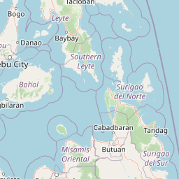
Map view of Cabadbaran-Santiago Watershed Forest Reserve

Use this park location map to pinpoint Cabadbaran-Santiago Watershed Forest Reserve in Philippines, understand its exact geographic position, and read its mapped placement within the surrounding landscape more clearly.

Pigeon | © OpenStreetMap contributors

Location context for Cabadbaran-Santiago Watershed Forest Reserve

Agusan del Norte
Park atlas

Compare regional mountain reserves, forest catchments, and connected conservation areas across Mindanao

Parks Near Cabadbaran-Santiago Watershed Forest Reserve and Surrounding Protected Landscapes

Browsing other protected areas near Cabadbaran-Santiago Watershed Forest Reserve reveals the broader ecological network of the Diwata Mountain range and surrounding regional catchments. Comparing adjacent forest reserves and mountain habitats provides valuable geographic context for understanding Mindanao conservation lands.
Nature reserveAgusan del Sur
About 39 km away#1 closest

South

Andanan Watershed Forest Reserve: Protected Landscape and Watershed Geography in Agusan del Sur

Exploring the Diwata Mountains and Andanan River headwaters

Spanning mountainous terrain in Agusan del Sur, the Andanan Watershed Forest Reserve acts as a primary catchment area for the Andanan River system. This nature reserve sustains a mosaic of forest and grassland habitats within the Diwata Mountains, representing a vital node in the regional protected-area network of Mindanao.

Area
150.97 km²
Established
1991
Relief
Mountain
Scope
Terrestrial
Protected landscapeSurigao del Norte
About 58 km away#2 closest

North

Mahaba Island Protected Landscape and Seascape: Regional Geography and Island Reserve

A combined coastal and marine protected area in Surigao del Norte.

Spanning both a flat sandy island and its surrounding sea, Mahaba Island Protected Landscape and Seascape illustrates the integrated conservation model of the Philippines. Discover the layered geography of mangrove-fringed shorelines, interior coconut patches, and marine habitats that form this protected reserve in the Caraga region.

Area
57.04 km²
Established
1991
Relief
Lowland
Climate
Tropical
Protected landscapeSurigao del Norte
About 79 km away#3 closest

Northeast

Siargao Islands Protected Landscape and Seascape: Geographic Atlas and Park Profile

Protected marine and island landscapes in Surigao del Norte

Spanning Siargao, Bucas Grande, and surrounding islets, this major reserve offers a unique look at the integration of karst-featured terrestrial landscapes with diverse marine zones. Trace the boundaries of a significant Philippine protected area defined by its dense coral reefs, sheltered lagoons, and expansive seagrass meadows supporting rare coastal biodiversity.

Area
2,789.14 km²
Established
1996
Relief
Upland
Climate
Tropical
Wildlife reserveAgusan del Sur
About 98 km away#4 closest

South

Agusan Marsh Wildlife Sanctuary: Mapping a Vast Freshwater Protected Area

Swamp forests and river basin geography in Agusan del Sur

Agusan Marsh Wildlife Sanctuary represents a crucial freshwater wetland complex within the Agusan River basin. The area is defined by its expansive swamp forests and semi-permanent floating lakes, which serve as essential migratory transit points and support an intricate network of aquatic ecosystems across the Mindanao region.

Area
148.36 km²
Established
1996
IUCN
IV
Relief
Lowland
National parkLanao del Sur
About 173 km away#5 closest

Southwest

Rungkunan National Park: Mapped Protected Landscape and Regional Geography Overview

Discover Rungkunan National Park's protected boundaries and landscape context.

Gain insight into Rungkunan National Park, a protected national park situated in Lanao del Sur. This page details the park's geographic positioning, mapped outlines, and its significance as a conservation landscape. It provides essential context for understanding the distribution of protected areas and the regional geography of the Philippines, facilitating a deeper atlas-style exploration.

Established
1965
IUCN
V
Water
Minor water
Protected landscapeBohol
About 181 km away#6 closest

West

Rajah Sikatuna Protected Landscape: Mapping the Limestone Forest of Bohol, Philippines

A vital protected area of karst ridges and endemic forest habitats

Rajah Sikatuna Protected Landscape sits as a premier natural landmark in southern Bohol. This area is defined by its extensive karst topography, significant cave systems, and expansive limestone forests. It serves as an essential ecological anchor for the province, offering a unique perspective on the island's diverse upland geography and natural mountain systems.

Area
104.526 km²
Established
1987
IUCN
V
Relief
Mountain
National parkLanao del Sur
About 181 km away#7 closest

Southwest

Salikata National Park: Explore Philippines National Park Geography

Mapped protected area boundaries and regional context.

Investigate Salikata National Park, a key protected area designated as a national park within Lanao del Sur, Philippines. This detailed view provides essential context for understanding its mapped boundaries, its place in the regional geography, and its significance as a protected landscape. Discover the unique geographic attributes that define Salikata National Park for atlas-based exploration.

Established
1965
IUCN
V
Relief
Mountain
Climate
Tropical
National parkPhilippines
About 185 km away#8 closest

Northwest

Kuapnit Balinsasayao National Park: Philippines Old-Growth Forest and Endemic Wildlife Atlas

Explore protected landscape boundaries and mountainous terrain on Leyte Island.

Kuapnit Balinsasayao National Park stands as a key protected area within the Philippines, distinguished by its mature old-growth forests and its critical role in conserving endemic bird species unique to the Eastern Visayas. Located on Leyte Island within the mountainous terrain of the Anonang-Lobi Mountain Range, the park's protected landscape identity is central to understanding its geographic significance. This park offers a valuable entry point for exploring the mapped natural features and conservation importance of protected areas across the Philippine archipelago.

Area
3.64 km²
Established
1937
IUCN
V
Relief
Mountain

Common questions about visiting, size, designation, and location context for Cabadbaran-Santiago Watershed Forest Reserve

Cabadbaran-Santiago Watershed Forest Reserve FAQs for park facts, access, geography, and protected area context

Find quick answers about Cabadbaran-Santiago Watershed Forest Reserve, including protected-area facts, park geography, trail and visitor context, and how the park fits into its surrounding country and regional landscape.
MoriAtlas Explorer

Continue Your Protected Areas Search Across the Global Atlas

Deepen your exploration by continuing the structured search for national parks and protected areas worldwide. Utilize the comprehensive filtering capabilities to compare different conservation landscapes and refine your understanding of global park geography. Discover more about the distribution and characteristics of protected natural areas.

Global natural geography