

Mori Atlas logo
Nature reserveCecil Hoskins Nature Reserve

A vital riverine refuge and mapped ecological sanctuary in the New South Wales interior

Cecil Hoskins Nature Reserve Protected Area and Wetland Geography in the Southern Highlands

Cecil Hoskins Nature Reserve comprises a 46-hectare protected wetland centered on the dammed Wingecarribee River in the Southern Highlands of New South Wales. This reserve preserves critical riverine swamp and remnant eucalypt woodland, serving as a drought refuge for migratory waterbirds. Its landscape is characterized by a transition from open floodplains to dense patches of snow gum and Camden woollybutt, offering a unique study in managed ecological recovery within a rural, historically cleared environment.

nature reserveSouthern Highlandswetlandswampriverine habitatbirdwatching

Cecil Hoskins Nature Reserve

Nature reserve

Park overview

Structured park overview, official facts, and landscape profile for Cecil Hoskins Nature Reserve

Cecil Hoskins Nature Reserve park facts, protected area profile, and essential visitor context

Review the core facts for Cecil Hoskins Nature Reserve, including designation, size, terrain, visitor scale, habitats, and operating context in one park-focused overview.

About Cecil Hoskins Nature Reserve

Cecil Hoskins Nature Reserve sits in the gently rolling countryside of the Southern Highlands of New South Wales, between the historic towns of Bowral and Moss Vale. Although the reserve covers only about 46 hectares, it carries an ecological identity shaped by the Wingecarribee River, which has been dammed within the reserve to create a swamp and wetland system that anchors its natural values. The broader region around the reserve has long been used for pasture and orchards, and the reserve represents one of the few places in the immediate area where wetland habitat is actively protected.

The reserve is far more than a simple patch of bush. It combines a permanently watered wetland, open grassy areas that were originally cleared in the early colonial period, and scattered stands of remnant native vegetation. Among the surviving trees are some of the best examples of snow gums in the Southern Highlands, along with the rare Camden woollybutt, a eucalypt of limited regional distribution. Recent planting efforts have worked to expand these native vegetation areas, slowly rebuilding a bushland character in a landscape that was heavily cleared in the 1820s by explorer and settler Charles Throsby.

Visitors typically encounter the reserve as a peaceful, lightly developed site offering picnic facilities, barbecues, and public toilets. Managed by the NSW National Parks and Wildlife Service, it functions as both a recreational green space for local communities and a working conservation site, particularly for waterbirds. The reserve's role as a drought refuge, its bird diversity, and its blend of restored and remnant habitat all contribute to its significance, while the surrounding Southern Highlands scenery gives it a broader scenic setting that complements the experience of visiting.

Quick facts and research context for Cecil Hoskins Nature Reserve

Cecil Hoskins Nature Reserve is a 46-hectare protected nature reserve in the Southern Highlands of New South Wales, located between Bowral and Moss Vale. It is managed by the NSW National Parks and Wildlife Service and was formally established as a nature reserve in 1975, classified under the IUCN framework as a habitat and species management area.

The reserve is defined by a dammed reach of the Wingecarribee River and its associated swamp and wetland, with surrounding open ground and patches of remnant eucalypt bushland. It is particularly valued as an inland refuge for waterbirds, with roughly 90 bird species recorded, including migratory species and occasional appearances of rare birds such as the Australasian bittern.

Protection and recognition

Review documented terrestrial protection scope and international recognition records

Cecil Hoskins Nature Reserve Protection Status and Governance Framework

Cecil Hoskins Nature Reserve holds a documented terrestrial protection scope within the global conservation network. Review recorded designation details, management frameworks, and international recognition sources associated with this protected area.

Protection details

Protection scope
Terrestrial
Transboundary protection
No
Park context

Deeper park guide and search-rich context for Cecil Hoskins Nature Reserve

Cecil Hoskins Nature Reserve history, landscape, wildlife, and travel context

Explore Cecil Hoskins Nature Reserve through its history, landscape character, ecosystems, wildlife, conservation priorities, cultural context, and seasonal travel timing in a structured park guide built for atlas discovery and search intent.

Why Cecil Hoskins Nature Reserve stands out

Cecil Hoskins Nature Reserve is best known as a compact wetland and birdwatching site in the Southern Highlands, where a dammed section of the Wingecarribee River supports swampy habitat used by a wide variety of waterbirds. It functions as a vital refuge for migratory species and for inland birds during drought, giving the reserve an ecological importance that exceeds its small size. The reserve is also recognized for its unusual mix of open, historically cleared countryside and surviving remnants of native bushland, including some of the better stands of snow gums in the Southern Highlands and the locally rare Camden woollybutt. This blend of wetland, grassland, and remnant eucalypt woodland defines the reserve's character and makes it a quietly distinctive pocket of habitat within a heavily modified rural landscape.
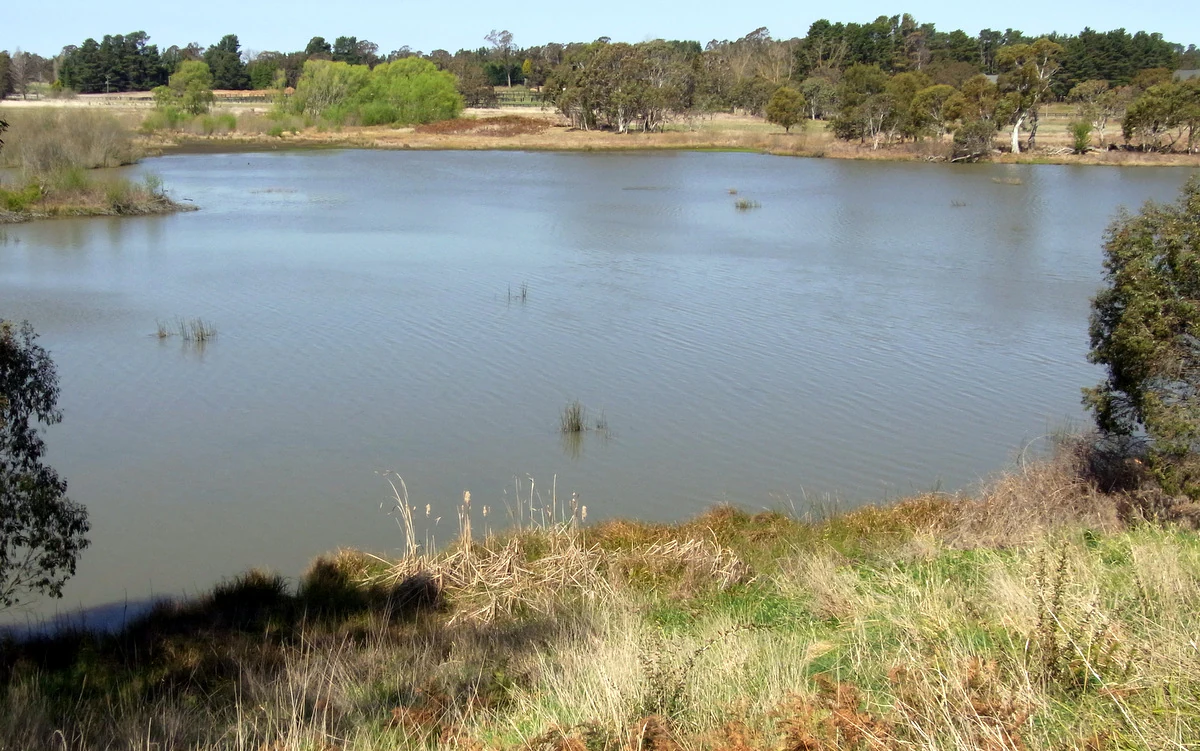
A wide landscape view of a calm body of water surrounded by grassy banks and a line of trees in the background under a clear blue sky.
View of the dammed Wingecarribee River within Cecil Hoskins Nature Reserve.

Cecil Hoskins Nature Reserve history and protected-area timeline

The land within Cecil Hoskins Nature Reserve has a long history of European use, with the area being originally cleared by explorer and settler Charles Throsby in the 1820s. This early pastoral use shaped much of the open, grassy character that still defines parts of the reserve today, while remnants of the original bushland survived in pockets that have since become some of the most ecologically important parts of the site.

The reserve itself was formally established as a protected area on 7 March 1975, reflecting growing recognition of the need to safeguard wetland habitat and surviving native vegetation in the heavily modified Southern Highlands landscape. Its management was assigned to the NSW National Parks and Wildlife Service, placing it within the formal system of New South Wales nature reserves. Over time, the reserve has also been shaped by deliberate restoration, with recent plantings increasing the extent of native bushland beyond what originally survived.

The reserve's name honors Cecil Hoskins, a long-time resident of Exeter and Moss Vale who had a deep knowledge of trees, shrubs, and landscape design. His influence on the Southern Highlands is visible in several nearby parks and gardens, including the planned layout of the Portland Cement Works garden at Berrima and the development of Seymour Park in Moss Vale, and his legacy was a key reason this particular reserve was named in his honor.

Cecil Hoskins Nature Reserve landscape and geographic character

The landscape of Cecil Hoskins Nature Reserve is shaped primarily by the Wingecarribee River, which flows through the reserve and has been dammed to create a system of still water, swamp, and associated wetlands. These wetter areas give the reserve its defining scenery, with patches of open water, marshy ground, and fringing vegetation standing in contrast to the surrounding higher and drier country of the Southern Highlands.

Away from the river corridor, the reserve is largely open ground, much of it historically cleared for grazing and now managed as grassy open space. Interspersed within this open setting are small but important stands of native eucalypts, including some of the stronger examples of snow gum found anywhere in the Southern Highlands, alongside the locally rare Camden woollybutt. The resulting blend of wetland, grassland, and small patches of bush gives the reserve a layered, transitional character rather than a single dominant landform.

The reserve lies between Bowral and Moss Vale and sits within reach of the Throsby Park Historic Site, an important early colonial property near the reserve. Its modest scale makes the landscape feel intimate, with visitors able to easily move between open water, picnic clearings, and bushy edges within a short walk, and the wider Southern Highlands scenery provides a gentle, rural backdrop to the entire experience.

Cecil Hoskins Nature Reserve ecosystems, habitats, and plant life

Ecologically, Cecil Hoskins Nature Reserve is defined by a relatively compressed but meaningful mix of habitats. The dammed Wingecarribee River creates a permanent freshwater system of swamp, wetland, and open water, which in turn supports aquatic vegetation and the aquatic and semi-aquatic wildlife that depend on these conditions. The reserve's wetter zones are the most ecologically active parts of the site and the reason it holds such importance for waterbirds.

Surrounding the wetland, the reserve carries an unusual mix of open grassy ground and small remnants of native eucalypt forest. The presence of snow gums and the rare Camden woollybutt hints at the original character of the Southern Highlands before widespread clearing. Recent replanting efforts have strengthened this native vegetation base, gradually reconnecting scattered patches of bush and improving habitat continuity within the reserve.

Despite its small size and heavily modified surroundings, the reserve functions as a refuge habitat in a region that has otherwise lost much of its original vegetation cover. Its permanent water, mix of open and wooded areas, and protected status combine to create an ecological niche that supports a broad range of species relative to the area it occupies.

Cecil Hoskins Nature Reserve wildlife and species highlights

The wildlife profile of Cecil Hoskins Nature Reserve is dominated by its birdlife. At least 90 bird species have been recorded on the site, making it a recognized birdwatching destination in the Southern Highlands. The reserve is particularly important for migratory waterbirds, which use the wetland for resting and feeding at various points in the year. During periods of inland drought, many birds that typically live further from the coast find refuge here, taking advantage of the reserve's reliable water and habitat.

Among the more unusual sightings at the reserve are the blue-billed duck, a species of interest to Australian birdwatchers, and the Australasian bittern, a rare and secretive wetland bird of conservation concern. The presence of these species adds considerable ecological weight to what would otherwise be a small, ordinary reserve.

Beyond birds, the reserve supports native mammals such as the platypus, which depends on healthy river habitat, the Australian water rat, which is associated with the wetland margins, and the eastern grey kangaroo, which is recorded in the area. Feral foxes are present and have caused significant damage to local wildlife, prompting active control through shooting, poisoning, and trapping as part of the reserve's ongoing management.

Cecil Hoskins Nature Reserve conservation status and protection priorities

Cecil Hoskins Nature Reserve was formally protected in 1975 and is now managed as a nature reserve under the New South Wales National Parks and Wildlife Service, with its conservation role recognized under the IUCN framework as a habitat and species management area. This designation reflects the reserve's purpose of safeguarding specific habitats and species rather than preserving an entirely intact natural landscape.

The reserve's main conservation value lies in its wetland. In a region that has been extensively cleared for agriculture since the 1820s, the dammed section of the Wingecarribee River and its associated swamp represent one of the few persistent freshwater habitats left in the immediate area. As a result, the reserve plays an important role as a refuge, especially during drought, when birds and other wildlife from drier inland areas concentrate in any remaining suitable habitat.

Conservation work at the reserve is ongoing. Active fox control efforts aim to reduce pressure on ground-nesting birds and small native mammals, while planting programs are gradually restoring native bushland beyond the surviving remnants. Together, these efforts work to maintain the reserve's mix of wetland, open ground, and native vegetation, ensuring that its ecological function continues even as the surrounding landscape remains heavily modified.

Cecil Hoskins Nature Reserve cultural meaning and human context

The cultural identity of Cecil Hoskins Nature Reserve is closely linked to the early colonial history of the Southern Highlands. Much of the reserve's land was originally cleared by Charles Throsby in the 1820s, and the nearby Throsby Park Historic Site preserves the legacy of that pioneering era. This early pastoral and agricultural shaping of the landscape is part of why the reserve today blends open country with patches of surviving native vegetation.

The reserve's name reflects a different strand of local heritage. Cecil Hoskins was a respected figure across the Southern Highlands, remembered for his deep knowledge of horticulture and his influence on the design of several important parks and gardens in the region, including Seymour Park in Moss Vale and the gardens of the Portland Cement Works at Berrima. His legacy as a creator of green spaces shaped the way the local community came to value this particular reserve.

For visitors, the reserve also carries a gentle layer of everyday cultural use. Its barbecue facilities, picnic areas, and public toilets make it a relaxed community space as much as a nature reserve, and the experience of visiting it is shaped by the kind of quiet, rural Southern Highlands atmosphere that surrounds Bowral, Moss Vale, and the smaller villages nearby.

Top sights and standout views in Cecil Hoskins Nature Reserve

The Cecil Hoskins Nature Reserve's standout quality is the way a compact 46-hectare site delivers a surprising mix of habitats, from a dammed stretch of the Wingecarribee River and its associated swamp to open ground, scattered eucalypt woodland, and actively restored native bushland. This diversity, set within the wider Southern Highlands context, makes the reserve feel larger and richer than its modest footprint suggests.

Its birdlife is another defining feature. With around 90 species recorded and a strong role as a refuge for migratory and drought-affected waterbirds, the reserve holds genuine ecological value, particularly through occasional sightings of rare species such as the Australasian bittern. Combined with its cultural namesake, its early colonial history, and its quietly attractive scenery, this mix of ecological and human heritage gives the reserve a layered and distinctive identity.

Best time to visit Cecil Hoskins Nature Reserve

The reserve can be visited throughout the year, but its character shifts with the seasons. Spring and early summer tend to bring the most active bird displays, with migratory waterbirds and breeding behavior making the wetland areas particularly lively. Cool, clear Southern Highlands mornings during these seasons also offer comfortable conditions for walking and birdwatching.

Autumn brings softer light and quieter conditions, making it a good period for visitors who prefer a more peaceful atmosphere and for observing kangaroos and other mammals around the grassy edges. Winter can be crisp and cold in the Highlands, but persistent water in the reserve means waterbirds are usually still active, and the snow gum stands take on a deeper character in the cooler months. During dry periods inland, the reserve often becomes especially significant ecologically, as drought-driven birds concentrate around the permanent water, making almost any season potentially rewarding for birdwatchers.


Monthly climate preview

Long-term temperature ranges and precipitation patterns measured across the protected terrain

Cecil Hoskins Nature Reserve Climate Normals and Monthly Weather Records

Representative coordinate data records a measured annual temperature rhythm alongside consistent monthly precipitation patterns spanning a 1991 to 2020 climatology period. Examining the full twelve-month profile reveals detailed baseline fluctuations in average temperature and daily moisture across the New South Wales reserve.
Annual mean15 °C
9 °C21 °C
Jan21°
Feb21°
Mar19°
Apr16°
May13°
Jun10°
Jul
Aug10°
Sep13°
Oct15°
Nov18°
Dec20°
Warmest month
January

21.4 °C

Coolest month
July

9.2 °C

Wettest month
February

4.5 mm/day

Driest month
July

1.8 mm/day

Park location guide

Geography guide, regional context, and park location map for Cecil Hoskins Nature Reserve

Cecil Hoskins Nature Reserve park geography, regions, and map view in Australia

Understand where Cecil Hoskins Nature Reserve sits in Australia through a broader geographic reading of the surrounding landscape, nearby location context, and its mapped position within the national park landscape.

How Cecil Hoskins Nature Reserve fits into Australia

Australia is a constitutional monarchy and federal parliamentary democracy comprising six states and ten territories. With a population of nearly 28 million, it is one of the world's most urbanised countries, with most people concentrated on the eastern seaboard. The country has a high Human Development Index and is known for its cultural diversity, ancient Aboriginal heritage, and unique wildlife.

Wider geography shaping Cecil Hoskins Nature Reserve in Australia

Australia occupies the entire Australian continent, the island of Tasmania, and numerous smaller islands. It is the world's flattest and driest inhabited continent, featuring vast deserts in the interior (the Outback), tropical rainforests along the eastern coast, and a coastline bordering the Indian and Pacific Oceans.

Map view of Cecil Hoskins Nature Reserve

Use this park location map to pinpoint Cecil Hoskins Nature Reserve in Australia, understand its exact geographic position, and read its mapped placement within the surrounding landscape more clearly.

Pigeon | © OpenStreetMap contributors

Location context for Cecil Hoskins Nature Reserve

New South Wales

Visualizing wetland habitats and riverine terrain across the Southern Highlands

Cecil Hoskins Nature Reserve Photos: Landscape and Scenery Views

Visual records reveal the diverse swampy floodplains and remnant eucalypt woodlands defining Cecil Hoskins Nature Reserve. Examining national park photography helps researchers understand local protected area terrain and riverine wetland environments.

A wide landscape view of a calm body of water surrounded by grassy banks and a line of trees in the background under a clear blue sky.

Park atlas

Compare nearby wetland habitats, river corridors, and regional reserve networks.

Other Parks Near Cecil Hoskins Nature Reserve And Surrounding Protected Landscapes

Browse protected areas and regional reserves located near Cecil Hoskins Nature Reserve in the Southern Highlands. Expanding the search reveals connected wetland habitats, riverine corridors, and neighboring conservation landscapes across New South Wales.
Watercolor landscape illustration showing green fields, trees, hills, and pastel sky
National parkNew South Wales
About 13 km away#1 closest

South

Morton National Park: A Protected Landscape of Waterfalls and Dissected Plateaus in New South Wales

Explore its mapped boundaries and regional geographic context.

Morton National Park is a nationally recognized protected area within New South Wales, Australia, celebrated for its striking natural features and geographic significance. The park's landscape is characterized by a dramatic dissected plateau, giving rise to impressive waterfall systems such as Fitzroy Falls and Belmore Falls that cascade into deep gorges. As a key component of the Southern Highlands' natural heritage, Morton National Park provides a rich subject for atlas exploration, offering insights into regional terrain, protected land distribution, and the unique interplay of natural elements within this Australian national park.

Area
1,997.45 km²
Established
1967
IUCN
II
Relief
Mixed relief
National parkNew South Wales
About 18 km away#2 closest

North

Nattai National Park: Protected Landscape Within New South Wales Geography

Mapped boundaries and regional context for this national park.

Nattai National Park represents a distinct protected landscape within the broader geographic context of New South Wales, Australia. This entry focuses on its identity as a national park, detailing its mapped boundaries and its significance for structured geographic and atlas exploration. Users can uncover the specific park identity and its role within the regional mapped terrain.

Area
489.84 km²
Established
1991
IUCN
II
Visitors
1K annual
National parkNew South Wales
About 19 km away#3 closest

Northwest

Bangadilly National Park: Protected Sandstone Plateau and Gorge Landscape in NSW

Explore its unique terrain and Wingecarribee River geography.

Bangadilly National Park, situated in New South Wales, is a critical protected area characterized by its striking sandstone plateau and gorge formations bordering the Wingecarribee River. As a strict nature reserve, it safeguards a significant transition zone for local flora and provides essential habitat for numerous rare and threatened species, making it a key site for understanding regional landscape ecology and protected area distribution in Australia.

Area
21.35 km²
Established
2001
IUCN
Ia
Relief
Mixed relief
National parkNew South Wales
About 19 km away#4 closest

Southeast

Budderoo National Park: Protected Landscape Exploration in New South Wales

Mapping the protected area and its regional geographic context.

Gain a clear understanding of Budderoo National Park as a protected national park situated within New South Wales. This detail page focuses on its mapped geographic features and protected landscape characteristics, providing critical context for atlas-based discovery. Explore the park's position within the broader regional geography of Australia and appreciate its identity as a conservation landscape.

Area
72.19 km²
Established
1986
IUCN
II
Climate
Subtropical
Nature reserveNew South Wales
About 19 km away#5 closest

East

Robertson Nature Reserve: Mapping a Rare Rainforest Remnant in the New South Wales Highlands

Protected warm temperate rainforest and escarpment geography

Robertson Nature Reserve serves as a vital conservation anchor in the New South Wales Southern Highlands. This reserve protects a dense fragment of warm temperate rainforest, characterized by its low canopy and rich basaltic soil composition. The area offers an opportunity to study the distinct ecology of the historic Yarrawa Brush and its adaptation to the high rainfall conditions along the Illawarra Escarpment.

Area
0.053 km²
Established
1979
Relief
Upland
Climate
Temperate
Nature reserveNew South Wales
About 20 km away#6 closest

Southeast

Barrengarry Nature Reserve: A Protected Forest Mosaic in New South Wales, Australia

Illawarra hinterland geography and forest ecosystem mapping

Barrengarry Nature Reserve protects a 21-hectare mosaic of warm temperate rainforest and eucalyptus forest. Situated near Kangaroo Valley, the area demonstrates complex habitat transition and serves as a significant site for threatened species conservation within the broader New South Wales ecological landscape.

Area
0.21 km²
Established
2001
IUCN
Ia
Scope
Terrestrial
National parkNew South Wales
About 22 km away#7 closest

East

Macquarie Pass National Park: National Park Protected Landscape and Regional Geography

Mapped protected area boundaries and natural terrain context.

Macquarie Pass National Park is an important protected natural landscape situated in New South Wales. This page offers an atlas-focused view, detailing the park's precise geographic extent and its significance as a national park. Understanding its mapped boundaries and its position within the regional geography allows for a deeper appreciation of its protected status and the natural terrain it encompasses, serving as a key entry point for geographic discovery.

Area
11 km²
Established
1969
IUCN
II
Relief
Mountain
Nature reserveNew South Wales
About 23 km away#8 closest

South

Kangaroo River Nature Reserve: Protected Valley Landscapes in New South Wales

Mapping rainforest gullies and diverse forest ecosystems

Located in the heart of the Kangaroo Valley, this nature reserve protects a vital ecological corridor of sclerophyll forest and rainforest. Its distinct gully systems and volcanic soil pockets provide essential habitat, serving as a cornerstone of the broader Shoalhaven protected landscape network in southern New South Wales.

Area
1.26 km²
Established
2001
IUCN
Ia
Relief
Upland

Common questions about visiting, size, designation, and location context for Cecil Hoskins Nature Reserve

Cecil Hoskins Nature Reserve FAQs for park facts, access, geography, and protected area context

Find quick answers about Cecil Hoskins Nature Reserve, including protected-area facts, park geography, trail and visitor context, and how the park fits into its surrounding country and regional landscape.
MoriAtlas Explorer

Continue Your Protected Areas Search Across the Global Atlas

Deepen your exploration by continuing the structured search for national parks and protected areas worldwide. Utilize the comprehensive filtering capabilities to compare different conservation landscapes and refine your understanding of global park geography. Discover more about the distribution and characteristics of protected natural areas.

Global natural geography