

Mori Atlas logo
Wildlife reserveCedar River National Grassland

A detailed geographic look at the prairie terrain and watershed character of this federal grassland

Cedar River National Grassland: Exploring North Dakota Protected Area Boundaries and Landscapes

Cedar River National Grassland represents a distinct segment of the northern Great Plains, spanning rolling prairie hills and intermittent stream corridors in southern North Dakota. This protected landscape, administered within the Dakota Prairie Grasslands network, offers a clear window into regional mixed-grass prairie ecosystems. The area preserves significant open-space character where federal land management overlaps with the Standing Rock Sioux Reservation, creating a unique geographic and cultural footprint across the regional watershed.

national grasslandgreat plainsmixed-grass prairieprairie conservationNorth DakotaStanding Rock Sioux Reservation

Cedar River National Grassland

Wildlife reserve

Park overview

Structured park overview, official facts, and landscape profile for Cedar River National Grassland

Cedar River National Grassland park facts, protected area profile, and essential visitor context

Review the core facts for Cedar River National Grassland, including designation, size, terrain, visitor scale, habitats, and operating context in one park-focused overview.

About Cedar River National Grassland

Cedar River National Grassland occupies a modest but ecologically meaningful footprint in the southernmost tier of North Dakota, where the state meets the South Dakota border. Comprising approximately 6,717 acres in Sioux and Grant counties, it sits within a transitional sliver of the northern Great Plains, a region defined historically by expansive grasslands, open skies, and the headwater drainages that connect the Missouri River basin with the surrounding plains.

The landscape is shaped by level plains and rolling hills, with a network of seasonal and intermittent streams. Many of these channels run dry for much of the year, while a few small flowing streams maintain more consistent water presence. This combination of rolling uplands, shallow valleys, and intermittent drainages supports the mixed-grass prairie ecosystem that once dominated much of the region.

A notable feature of the grassland is its overlap with the Standing Rock Sioux Reservation in its Sioux County portion. This places part of the federal grassland on tribally significant land and reflects the broader pattern across the northern Plains where federal land management units and tribal boundaries intersect. The cultural and ecological importance of these lands has long been recognized both by tribal communities and by federal conservation agencies.

Administratively, the grassland is managed by the U.S. Forest Service as part of the Dakota Prairie Grasslands, a consolidated administrative unit that brings together multiple National Grasslands in North Dakota and South Dakota under coordinated oversight. Day-to-day operations are handled through shared ranger district offices in Lemmon, South Dakota, which also serve the neighboring Grand River National Grassland, with overall administration based in Bismarck, North Dakota.

While Cedar River National Grassland is small relative to western forest or grassland units, its value lies in its contribution to a connected prairie landscape and its representation of an ecosystem that has seen significant conversion to agriculture across the region. As part of a broader network of Dakota grasslands, it helps sustain wildlife habitat, native plant communities, and the open-space character of the Great Plains.

Quick facts and research context for Cedar River National Grassland

Cedar River National Grassland is a National Grassland in southern North Dakota, spanning Sioux and Grant counties near the South Dakota border. Its closest community reference point is Lemmon, South Dakota. The total area is about 6,717 acres, or roughly 27 square kilometers.

The grassland is part of the Standing Rock Sioux Reservation in its Sioux County portion and is administered by the U.S. Forest Service under the Dakota Prairie Grasslands unit. Management and ranger operations are shared with Grand River National Grassland out of Lemmon, South Dakota, with broader oversight from Bismarck, North Dakota.

Protection and recognition

Terrestrial protected area framework and official recognition records

Cedar River National Grassland Protection Status and Designated Area Record

Cedar River National Grassland maintains a defined terrestrial protection scope within the broader protected area network. Official records compile documented management history, designation frameworks, and international recognition sources for structural analysis.

Protection details

Protection scope
Terrestrial
Transboundary protection
No
Park context

Deeper park guide and search-rich context for Cedar River National Grassland

Cedar River National Grassland history, landscape, wildlife, and travel context

Explore Cedar River National Grassland through its history, landscape character, ecosystems, wildlife, conservation priorities, cultural context, and seasonal travel timing in a structured park guide built for atlas discovery and search intent.

Why Cedar River National Grassland stands out

Cedar River National Grassland is best known as a representative tract of the northern Great Plains mixed-grass prairie, characterized by level plains, rolling hills, dry streambeds, and the gentle drainages that feed into the Cedar River watershed. The grassland's defining identity is its combination of small-scale prairie preservation and its location partly within the Standing Rock Sioux Reservation, tying together tribal land heritage and federal grassland conservation. It also contributes to the larger Dakota Prairie Grasslands network, linking it to broader prairie habitat, watershed, and open-landscape conservation efforts across the region.
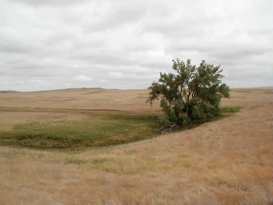
A lone green tree stands in a field of dry, golden grass under a cloudy sky, with a patch of greener vegetation at its base indicating a dry stream bed.
A Plains cottonwood tree growing along a tributary of the Cedar River within the Cedar River National Grassland.

Cedar River National Grassland history and protected-area timeline

Cedar River National Grassland was established under the National Grassland system administered by the U.S. Forest Service. It has been managed as part of the Dakota Prairie Grasslands, a Forest Service administrative grouping that unites scattered National Grassland holdings in the Dakotas to streamline planning, fire management, grazing coordination, and other shared operational functions.

The grassland has historically been part of the broader Standing Rock landscape, with its Sioux County portion lying within the Standing Rock Sioux Reservation. This reflects the long-standing intersection of tribal lands and federally managed public grassland tracts in the region, an arrangement that predates the consolidation of these holdings under the National Grassland umbrella.

Over time, federal and tribal authorities have coordinated land management priorities in ways that balance ecological conservation, watershed protection, and the cultural and practical interests of tribal communities on the reservation. The shared ranger office in Lemmon, South Dakota, which serves both Cedar River National Grassland and Grand River National Grassland, illustrates how this coordination operates at the local level.

Cedar River National Grassland landscape and geographic character

The terrain of Cedar River National Grassland is characteristic of the transitional northern Great Plains, with level plains giving way to gently rolling hills across much of the area. These landforms create subtle but persistent variation in elevation and exposure, supporting a mosaic of prairie vegetation types.

A defining feature of the landscape is its drainage pattern. The grassland is crossed by dry stream channels that carry water only seasonally, alongside a smaller number of small flowing creeks that maintain base flow through much of the year. Together, these drainages shape the topography and contribute to the broader Cedar River watershed of the region.

This mix of upland plains, low rolling hills, and intermittent stream corridors produces a recognizable prairie topography, where the eye can travel for considerable distances across open country and where sky and land define the visual character of the place.

Cedar River National Grassland ecosystems, habitats, and plant life

Cedar River National Grassland protects a representative portion of northern mixed-grass prairie, an ecosystem defined historically by a blend of cool-season and warm-season native grasses along with a diverse community of prairie forbs and shrubs. The combination of level plains, rolling hills, and dry and flowing drainages creates a variety of microhabitats within a relatively small land area.

This kind of mixed-grass landscape supports native plant communities adapted to the semi-arid continental climate of the northern Plains, including species that respond to drought, fire, grazing, and seasonal temperature extremes. The varied terrain offers subtle differences in soil moisture, aspect, and exposure that contribute to plant diversity across the grassland.

Because mixed-grass prairie has been substantially reduced across the Great Plains through agricultural conversion, tracts like Cedar River National Grassland play an outsize ecological role relative to their size. Even small public grassland units contribute to habitat continuity, watershed function, and the preservation of native plant and animal communities that depend on intact prairie.

Cedar River National Grassland wildlife and species highlights

The mixed-grass prairie ecosystem of Cedar River National Grassland supports a typical northern Great Plains wildlife community. Open-country birds, small mammals, and grassland-dependent species characteristic of the northern Plains region can occupy the area, using the cover provided by native grasses and forbs and the movement corridors shaped by dry and flowing stream channels.

The combination of uplands and drainages offers a range of habitats within a compact area, supporting the kind of species diversity typical of healthy mixed-grass sites. Even where individual species populations are modest, the grassland contributes to broader regional wildlife patterns across the Dakota Prairie system.

Because the area is managed as part of a network of National Grasslands, its wildlife value is not only local; it also connects to habitat conditions across adjacent grasslands and to the wider northern Plains landscape.

Cedar River National Grassland conservation status and protection priorities

Cedar River National Grassland is significant from a conservation perspective because it preserves a working example of northern mixed-grass prairie within a region where most native prairie has been converted to cropland or pasture. By maintaining native vegetation, open space, and a functioning watershed, the grassland contributes directly to habitat, soil, and water conservation in the southern North Dakota landscape.

As part of the Dakota Prairie Grasslands administrative unit, the grassland benefits from coordinated regional management that integrates fire, grazing, and vegetation management across multiple National Grasslands. This networked approach helps sustain ecological processes at a scale appropriate for prairie ecosystems, even when individual units like Cedar River are relatively small.

The grassland also carries an additional layer of conservation significance because a portion lies within the Standing Rock Sioux Reservation. This relationship connects federal grassland conservation with tribal land stewardship, two traditions that together shape the long-term protection of the area.

Cedar River National Grassland cultural meaning and human context

The most important cultural dimension of Cedar River National Grassland is its overlap with the Standing Rock Sioux Reservation, through which the Standing Rock Sioux Tribe has longstanding ties to the land, its resources, and its landscape. The intersection of federal grassland management and tribal jurisdiction in this part of North Dakota reflects the broader history of the northern Plains, where tribal nations have deep cultural, historical, and ecological relationships with prairie landscapes.

For visitors and researchers, this context is central to understanding the grassland. The land is not simply an abstract ecological site; it is part of a living regional landscape with indigenous heritage, contemporary tribal presence, and an ongoing relationship between tribal communities and the federal agencies that co-manage portions of the area.

Top sights and standout views in Cedar River National Grassland

A representative tract of northern mixed-grass prairie in southern North Dakota, with rolling plains and intermittent stream corridors typical of the upper Great Plains. The grassland's overlap with the Standing Rock Sioux Reservation gives it cultural significance beyond its ecological value, connecting federal conservation with tribal land stewardship.

As part of the Dakota Prairie Grasslands network, Cedar River National Grassland contributes to coordinated prairie conservation and shares management infrastructure with neighboring Grand River National Grassland. Its combination of openness, subtle topography, and prairie character captures the essence of the Dakota plains even at a modest scale.

Best time to visit Cedar River National Grassland

The character of Cedar River National Grassland shifts with the seasons in ways typical of the northern Great Plains. Late spring and early summer bring fresh growth across the prairie, with native grasses beginning to green up and wildflowers emerging in favorable conditions. This period offers the most visually active landscape and is generally comfortable for outdoor activity.

Summer brings warmer temperatures and the full expression of the mixed-grass prairie, with mature grasses and continued wildflower displays. Early mornings and evenings tend to be the most pleasant times to experience the open landscape. Wildlife and bird activity often peak during these seasons as well.

Fall cools the prairie and changes its color palette, with grasses turning golden and the landscape taking on a more muted, expansive feel. Winters in the region can be cold and at times snowy, producing a stark but distinctive prairie atmosphere. Visitors interested in the open-landscape character of the area may appreciate any season, with each offering a different angle on the grassland.
Monthly climate preview

Long term representative temperature and precipitation averages across twelve months

Cedar River National Grassland Climate Normals and Annual Weather Patterns

Cedar River National Grassland experiences a wide annual temperature range alongside distinct monthly precipitation variations recorded at representative coordinates from 1991 to 2020. Reviewing the complete monthly climate profile provides deeper insight into long term averages for temperature extremes and precipitation patterns.
Annual mean7 °C
-8 °C23 °C
Jan-8°
Feb-5°
Mar
Apr
May13°
Jun19°
Jul23°
Aug22°
Sep16°
Oct
Nov
Dec-6°
Warmest month
July

23.3 °C

Coolest month
January

-7.6 °C

Wettest month
June

2.7 mm/day

Driest month
January

0.4 mm/day

Park location guide

Geography guide, regional context, and park location map for Cedar River National Grassland

Cedar River National Grassland park geography, regions, and map view in United States of America

Understand where Cedar River National Grassland sits in United States of America through a broader geographic reading of the surrounding landscape, nearby location context, and its mapped position within the national park landscape.

How Cedar River National Grassland fits into United States of America

The United States of America is a federal presidential republic and one of the world's largest countries by area and population. It consists of 50 states across a vast territory spanning multiple time zones, with its capital in Washington, D.C. and largest city in New York City. The nation has a diverse economy, influential political system, and significant cultural and military presence globally.

Wider geography shaping Cedar River National Grassland in United States of America

The United States occupies a vast territory in North America, bordered by Canada to the north and Mexico to the south. The 48 contiguous states stretch from the Atlantic to the Pacific Ocean, while Alaska occupies the northwestern region and Hawaii is an archipelago in the Pacific. The country encompasses diverse terrain including the Rocky Mountains, Appalachian Mountains, Great Plains, and extensive river systems.

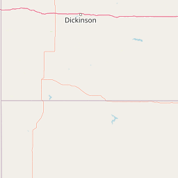
Map view of Cedar River National Grassland

Use this park location map to pinpoint Cedar River National Grassland in United States of America, understand its exact geographic position, and read its mapped placement within the surrounding landscape more clearly.

Pigeon | © OpenStreetMap contributors

Location context for Cedar River National Grassland

North Dakota

Explore photographic records of mixed grass prairie terrain, rolling hills, and river drainages.

Cedar River National Grassland Photos and Scenery: Visualizing Northern Great Plains Landscapes

Visual documentation captures the open terrain, transitional mixed grass prairie, and dry stream corridors that define the protected landscape. Examining these photographs helps observers understand the subtle topography and ecological character of the upper Great Plains.

A lone green tree stands in a field of dry, golden grass under a cloudy sky, with a patch of greener vegetation at its base indicating a dry stream bed.

Park atlas

Compare adjacent Great Plains terrain and connected regional conservation areas

Parks Near Cedar River National Grassland and Surrounding Protected Landscapes

Browsing other protected areas near Cedar River National Grassland reveals broader ecological patterns across the northern mixed-grass prairie. Comparing these neighboring habitats provides essential regional context for understanding regional watershed preservation.
Protected landscapeSouth Dakota
21 km away#1 closest

Southwest

Grand River National Grassland: Protected Landscape and Regional Geography in South Dakota

Mapped prairie, riparian corridors, and badland terrain.

Grand River National Grassland represents a complex protected landscape in South Dakota. Managed by the U.S. Forest Service, this area features diverse landforms including sand dunes, claypan playas, and green ash draws. This record provides a structured geographic overview of the grassland mosaic, spanning Perkins, Corson, and Ziebach counties with significant cultural ties to local tribal lands.

Area
626.38 km²
Established
1960
Relief
Lowland
Climate
Temperate
Protected landscapeNorth Dakota
113 km away#2 closest

Northwest

Little Missouri National Grassland: Geography and Protected Landscape Context

Exploring North Dakota's expansive badlands and prairie terrain

Spanning over a million acres, Little Missouri National Grassland stands as a massive protected landscape in western North Dakota. This area showcases the complex transition where open mixed-grass prairie meets the eroded, rugged badlands of the Little Missouri River corridor. Home to White Butte, the state's highest point, the grassland offers a unique topographic profile of buttes, canyons, and canyons that defines the region's broader geographic and conservation character.

Area
4,163.34 km²
Established
1960
Relief
Upland
Climate
Temperate
National parkNorth Dakota
150 km away#3 closest

Northwest

Theodore Roosevelt National Park: Mapped Protected Landscape in North Dakota

Explore the geography and protected natural boundaries.

Theodore Roosevelt National Park represents a distinct protected landscape within North Dakota, offering a valuable entry point for exploring its unique geographic setting. This page provides a concentrated view of the park's mapped boundaries and its contribution to regional natural context. It is designed for users seeking detailed atlas-level information and a clear understanding of the park's protected-area status and geographic significance within the United States.

Area
285.08 km²
Established
1978
IUCN
II
Visitors
668.7K annual
Protected areaSouth Dakota
202 km away#4 closest

Southeast

Fort Pierre National Grassland: An Atlas of South Dakota Mixed-Grass Prairie Ecosystems

Exploration of central Great Plains protected terrain and boundaries

Focusing on the authentic mixed-grass prairie of South Dakota, Fort Pierre National Grassland serves as a critical example of northern Plains conservation. Its landscape, marked by sweeping vistas and seasonal wetlands, provides a deep look into the spatial character and ecological heritage of the interior United States. Gain a precise understanding of its boundaries and the surrounding geographic features that define this expansive public land.

Area
469 km²
Relief
Upland
Access
Access unknown
Scope
Terrestrial
National parkSouth Dakota
229 km away#5 closest

South

Badlands National Park: South Dakota's Premier National Park for Atlas Exploration

Explore mapped terrain and protected landscape boundaries.

Badlands National Park stands as a key protected area within the geography of South Dakota, offering a distinct natural landscape for detailed atlas exploration. This National Park's unique terrain and mapped boundaries provide crucial context for understanding regional geography and conservation landscapes. Engage with structured information that highlights the park's geographic identity, making it an essential destination for those seeking to map and comprehend protected natural areas.

Area
982.4 km²
Established
1939
IUCN
II
Visitors
1M annual
National parkCuster County
284 km away#6 closest

Southwest

Wind Cave National Park: A National Park with Distinct Protected Landscape and Geographic Identity

Explore the mapped terrain and regional context of this US protected area.

Wind Cave National Park represents a key protected area within Custer County, offering users a deep dive into its unique geography and landscape characteristics. As a designated national park in the United States, its mapped boundaries provide crucial context for understanding its ecological and geological significance. This MoriAtlas entry facilitates detailed exploration, focusing on the protected land's identity and its role within the wider regional geography and natural landscape.

Area
136.97 km²
Established
1903
IUCN
II
Visitors
489.4K annual
A pale, minimalist watercolor illustration of a wide, open grassy landscape with soft rolling hills in the background and light green vegetation in the foreground.
Protected landscapeSouth Dakota
About 284 km away#7 closest

South

Buffalo Gap National Grassland: Regional Geography and Protected Prairie Boundaries

Mapping the vast grasslands of southwestern South Dakota

Spanning across four counties in southwestern South Dakota, Buffalo Gap National Grassland serves as a premier example of a working Great Plains landscape. The region is defined by its immense scale, where undulating mixed-grass prairie transitions into striking, chalky badlands. This area is recognized for its vital conservation role, including successful species recovery programs, and stands as a foundational feature of the regional geological and ecological map.

Area
2,410.77 km²
Established
1960
Relief
Upland
Climate
Temperate
Protected landscapeWyoming
285 km away#8 closest

Southwest

Thunder Basin National Grassland: A Protected Landscape in the Wyoming Powder River Basin

Mapping the prairie and sagebrush mosaic of northeastern Wyoming

Thunder Basin National Grassland is a sprawling, federally protected territory in northeastern Wyoming that functions as a critical ecotone between the Great Plains and the Rocky Mountain region. Its landscape is characterized by wide-open vistas, intricate sedimentary bluffs, and diverse habitats shaped by natural disturbance patterns and ongoing grassland management. This record outlines the geography, terrain features, and protected boundaries that define this essential segment of the American West.

Area
2,215.65 km²
Established
1960
Relief
Upland
Climate
Arid

Common questions about visiting, size, designation, and location context for Cedar River National Grassland

Cedar River National Grassland FAQs for park facts, access, geography, and protected area context

Find quick answers about Cedar River National Grassland, including protected-area facts, park geography, trail and visitor context, and how the park fits into its surrounding country and regional landscape.
MoriAtlas Explorer

Continue Your Protected Areas Search Across the Global Atlas

Deepen your exploration by continuing the structured search for national parks and protected areas worldwide. Utilize the comprehensive filtering capabilities to compare different conservation landscapes and refine your understanding of global park geography. Discover more about the distribution and characteristics of protected natural areas.

Global natural geography