

Mori Atlas logo
Wildlife reserveChayu Nain Communal Reserve

Mapping the ecological transitions and sandstone ridge landscapes within the Cordillera del Condor

Chayu Nain Communal Reserve: A Comprehensive Geographic Profile of Northern Peru Protected Lands

(Reserva Comunal Chayu Nain)

Chayu Nain Communal Reserve encompasses more than 23,000 hectares of diverse terrain across the Bagua and Utcubamba provinces in the Amazonas region. This protected area represents a critical Andean and Amazonian interface, featuring a mosaic of high-altitude shrublands, sandstone ridges, and dense cloud forests. The reserve serves as a model for indigenous-led conservation efforts and provides essential habitat for endangered primates, Andean bears, and unique endemic species along its eastern escarpment.

Andean-Amazon transitioncommunal reserveindigenous-led conservationcloud forestlowland tropical forestsandstone ridges

Chayu Nain Communal Reserve

Wildlife reserve

Park overview

Structured park overview, official facts, and landscape profile for Chayu Nain Communal Reserve

Chayu Nain Communal Reserve park facts, protected area profile, and essential visitor context

Review the core facts for Chayu Nain Communal Reserve, including designation, size, terrain, visitor scale, habitats, and operating context in one park-focused overview.

About Chayu Nain Communal Reserve

The Chayu Nain Communal Reserve lies in northern Peru, where the eastern Cordillera del Cóndor descends from the Andes into the upper Amazon basin. It occupies a transitional zone between mountain ridges, cloud forests, and lowland tropical forest, spanning the Bagua and Utcubamba provinces of the Amazonas Region. Within Peru's national system of natural protected areas, Chayu Nain holds the status of a communal reserve, a category designed to recognize territories managed in close cooperation with Indigenous peoples and local communities for both conservation and sustainable use.

The landscape of the reserve is built around dramatic sandstone formations. Above the forested slopes, high-altitude shrublands and grasslands cover exposed rocky terrain, while below them, dense forests extend down toward the river valleys of the Marañón basin. This ecological staircase supports a mix of Andean, sub-Andean, and Amazonian species within a relatively compact area, making the reserve unusually rich for its size.

Chayu Nain is best understood as both a biodiversity refuge and a recognition of Indigenous stewardship. Its creation came at the request of the Awajun communities whose traditional territories include the area, and the reserve's management is tied directly to the priorities of those communities. Combined with its classification under IUCN Category VI, this makes Chayu Nain an example of how conservation in Peru increasingly integrates cultural identity, traditional land use, and protection of endangered ecosystems.

Quick facts and research context for Chayu Nain Communal Reserve

Chayu Nain is a communal reserve in the Amazonas Region of northern Peru, created on December 9, 2009, through Supreme Decree No. 021-2009-MINAM. Its territory covers more than 23,500 hectares across Bagua and Utcubamba provinces, where the Andes descend toward the Amazon basin along the Cordillera del Cóndor. The protected area is classified as IUCN Category VI, emphasizing sustainable use of natural resources by Indigenous and local communities, and it is administered by SERNANP at the national level. The reserve is particularly notable for endemic and threatened fauna tied to its sandstone ridges, cloud forests, and high-altitude shrublands.

Protection and recognition

Review documented terrestrial protection scope and conservation status details.

Chayu Nain Communal Reserve Protection Status and Governance Framework

Chayu Nain Communal Reserve maintains a documented terrestrial protection scope within the regional conservation network. Structured facts outline administrative management boundaries and official international recognition records.

Protection details

Protection scope
Terrestrial
Transboundary protection
No
Park context

Deeper park guide and search-rich context for Chayu Nain Communal Reserve

Chayu Nain Communal Reserve history, landscape, wildlife, and travel context

Explore Chayu Nain Communal Reserve through its history, landscape character, ecosystems, wildlife, conservation priorities, cultural context, and seasonal travel timing in a structured park guide built for atlas discovery and search intent.

Why Chayu Nain Communal Reserve stands out

Chayu Nain is known above all for protecting one of the last strongholds of the yellow-tailed woolly monkey, an endangered primate endemic to a narrow Andean-Amazonian corridor in northern Peru and southern Ecuador. The reserve also conserves high-altitude shrublands and grasslands on sandstone formations of the Cordillera del Cóndor, a geological and ecological gradient between the Andes and the Amazon basin. It is equally recognized as a model of communal conservation, created at the request of local Awajun communities as part of Peru's framework for Indigenous-led protected areas. The reserve's profile combines threatened primates, the only Andean bear species in South America, lowland tapirs, unusual endemic marsupials, and a distinctive bird community associated with the sandstone ridges and forests that define the area.

Chayu Nain Communal Reserve history and protected-area timeline

The Chayu Nain Communal Reserve was officially established on December 9, 2009, through Supreme Decree No. 021-2009-MINAM, signed under Peru's Ministry of Environment. Its creation formalized decades of Indigenous presence and stewardship in the area by the Awajun, whose traditional lands include the forests and sandstone ridges now encompassed by the reserve.

The reserve joined Peru's National System of Natural Protected Areas as a communal reserve, a category that reflects the country's evolving approach to conservation. Communal reserves are typically created at the initiative of local communities and are intended to combine the protection of biodiversity with the recognition of Indigenous land use, traditional knowledge, and community governance structures. Chayu Nain's inclusion in this category marked a milestone in expanding Indigenous-led conservation in the Amazonas Region.

Since its creation, the reserve has been administered by SERNANP, Peru's national service for natural protected areas, in coordination with the local Awajun communities. The protected-area status has helped consolidate attention on the area's threatened primates and other endemic species, while reinforcing local claims to traditional territory in a region where Andean and Amazonian ecosystems meet.

Chayu Nain Communal Reserve landscape and geographic character

The terrain of Chayu Nain is defined by the eastern flank of the Cordillera del Cóndor, a mountain range that forms part of the Andes-Amazon transition in northern Peru. Sandstone is a dominant geological feature, producing ridges, cliffs, and dissected plateaus that shape both the scenery and the drainage patterns of the reserve. These formations create abrupt transitions between high-elevation open habitats and steep forested slopes.

Above the forest line, the landscape includes high-altitude shrublands and grasslands growing on shallow soils over sandstone. These open habitats are interspersed with patches of stunted vegetation adapted to rocky substrates, and they contrast sharply with the dense evergreen forests found at lower elevations. Together, the elevation gradients and geological structure create a layered landscape in which Andean and Amazonian environments meet within a single protected area.

Below the sandstone ridges, the reserve extends into the upper tributaries of the Marañón river basin. Forest cover here is dense, and the terrain becomes more broken as streams cut through valleys between the ridges. The combination of rivers, valleys, sandstone walls, and high-elevation open country makes Chayu Nain a visually distinctive and ecologically varied protected area.

Chayu Nain Communal Reserve ecosystems, habitats, and plant life

The reserve protects a stratified set of ecosystems along the Andes-Amazon transition. At higher elevations, sandstone scrublands and grasslands host plant communities adapted to thin soils, cool temperatures, and high exposure. Moving downslope, vegetation shifts into montane and cloud-forest formations, eventually giving way to lowland tropical forest in the valleys and along the river systems that drain the reserve toward the Marañón basin.

This gradient allows Andean, sub-Andean, and Amazonian species to coexist in relatively close proximity. The high-altitude shrublands and grasslands of the sandstone plateaus support hardy vegetation specialized for rocky terrain, while the forested slopes below provide habitat for larger mammals and dense populations of trees and epiphytes. The mosaic of habitats is one of the defining ecological features of Chayu Nain and explains why the area harbors both cloud-forest and lowland-forest species.

The reserve's biodiversity is enhanced by its position along the Cordillera del Cóndor, a range known for endemic species tied to its sandstone geology. The combination of unusual substrates, altitudinal range, and relatively intact forest cover gives Chayu Nain a strong role within Peru's broader network of Andean-Amazon protected areas.

Chayu Nain Communal Reserve wildlife and species highlights

Chayu Nain is most strongly associated with the yellow-tailed woolly monkey, an endangered primate that survives in only a handful of Andean-Amazonian forests in northern Peru and southern Ecuador. The reserve is considered one of the important refuges for this species, which depends on primary forest along the eastern Andean slopes. Its presence is a central reason the area has received protected status and conservation attention.

The reserve also supports the spectacled bear, the only bear species in South America, which ranges across the upper elevations of the Cordillera del Cóndor and into the forested slopes. The South American tapir, a large browsing mammal associated with well-preserved forest, is also recorded in Chayu Nain, highlighting the presence of wide-ranging mammals that depend on extensive tracts of intact habitat. Birdlife in the reserve includes species tied to the sandstone ridges and humid forests, contributing to the region's growing profile for ornithology.

A particularly notable wildlife feature is the record of Caenolestes condorensis, an endemic marsupial described from the Cordillera del Cóndor. Its presence underlines the scientific importance of the reserve's high-elevation habitats and supports the recognition of the Cordillera del Cóndor as a center of endemism for small mammals as well as primates.

Chayu Nain Communal Reserve conservation status and protection priorities

Chayu Nain contributes to the protection of a recognized biodiversity corridor between the Andes and the Amazon, an interface consistently highlighted as a conservation priority in northern Peru. By encompassing a continuous gradient from sandstone highlands through cloud forest to lowland forest, the reserve buffers multiple ecosystems against the fragmentation pressures affecting the surrounding landscape. Its protected status places large tracts of the Cordillera del Cóndor under formal conservation management for the long term.

The reserve is also significant for threatened species conservation. The protection of remaining populations of the yellow-tailed woolly monkey, the maintenance of habitat for spectacled bears and tapirs, and the safeguarding of endemic species tied to the Cordillera del Cóndor's sandstone formations all give the area an outsized conservation value relative to its size. The presence of recently described endemic species suggests that further undocumented biodiversity may yet be found within the reserve.

Its IUCN Category VI status reflects the role of the Awajun communities and other local inhabitants as partners in conservation. By recognizing traditional land use alongside biodiversity protection, the reserve exemplifies an approach in which Indigenous stewardship and formal protection reinforce each other. Administered by SERNANP, Chayu Nain is part of the national strategy for protecting the country's distinctive Andean-Amazonian ecosystems and the species that depend on them.

Chayu Nain Communal Reserve cultural meaning and human context

Chayu Nain takes its name and character from the Awajun, an Indigenous people whose territories stretch across the forests and foothills of the Cordillera del Cóndor in northern Peru. The creation of the reserve at their request reflects a long-standing relationship between Awajun communities and the land it protects. Traditional knowledge of forest resources, hunting grounds, and sacred areas is closely tied to the geography of the reserve.

Communal reserves in Peru are designed to recognize the role of Indigenous and local communities in maintaining biodiversity through sustainable use of forest products, traditional management practices, and cultural continuity. Chayu Nain operates within this framework, and the cultural identity of the Awajun is woven into the reserve's purpose and governance. The combination of cultural heritage and ecological protection is one of the defining features of the protected area.

Top sights and standout views in Chayu Nain Communal Reserve

Chayu Nain protects a near-continuous Andean-Amazon gradient of more than 23,500 hectares along the eastern flank of the Cordillera del Cóndor. Its sandstone ridges, shrublands, cloud forests, and lowland forests support a level of ecological diversity that is rare within a single accessible protected area. The reserve is a recognized refuge for the endangered yellow-tailed woolly monkey and continues to produce significant records of endemic species, including marsupials unique to the Cordillera del Cóndor.

The reserve's character is shaped by its Awajun-led governance and its IUCN Category VI status, which together make it an important example of community-based conservation in Peru. The mix of threatened primates, Andean bears, lowland tapirs, and unusual endemic wildlife places Chayu Nain among the more distinctive protected areas in the country's northern Andean-Amazonian corridor.

Best time to visit Chayu Nain Communal Reserve

The climate of northern Peru's Andean-Amazon transition influences both the atmosphere and accessibility of Chayu Nain. The region has a markedly wet and dry seasonal pattern, with the dry months generally offering more stable conditions for traveling through forested terrain and along rural roads, while the wetter months bring heavy rainfall that can complicate trail travel and increase river levels. Cooler, clearer conditions often occur at higher elevations along the sandstone ridges during the dry season.

Wildlife observation tends to benefit from periods when fruiting trees support key species such as primates and birds, and from quieter forest conditions in the early dry months. Visitors focused on the area's endemic fauna and on experiencing the landscape in its more open, less rainy configuration generally find the dry season more suitable, while the wetter months emphasize the lush, fog-laden character of the cloud forests.

Monthly climate preview

Long term temperature averages and precipitation rhythms across the protected landscape

Chayu Nain Communal Reserve Climate Normals and Monthly Weather Patterns

Representative coordinates record measured monthly temperature ranges and precipitation levels from 1991 through 2020 at an elevation of 1550 meters. Complete twelve month records provide detailed comparative metrics for analyzing regional environmental variation.
Annual mean20 °C
19 °C20 °C
Jan20°
Feb19°
Mar19°
Apr19°
May19°
Jun19°
Jul19°
Aug20°
Sep20°
Oct20°
Nov20°
Dec20°
Warmest month
September

20.4 °C

Coolest month
June

18.8 °C

Wettest month
February

3.2 mm/day

Driest month
August

0.6 mm/day

Park location guide

Geography guide, regional context, and park location map for Chayu Nain Communal Reserve

Chayu Nain Communal Reserve park geography, regions, and map view in Peru

Understand where Chayu Nain Communal Reserve sits in Peru through a broader geographic reading of the surrounding landscape, nearby location context, and its mapped position within the national park landscape.

How Chayu Nain Communal Reserve fits into Peru

Peru is a megadiverse country in western South America with a population of over 34 million. It spans three distinct geographic regions: the Pacific coastal desert in the west, the Andes mountains running north to south, and the Amazon rainforest in the east. The country has one of the longest histories of civilization in the world, tracing back to the Caral-Supe civilization of the 10th millennium BCE, and was home to the Inca Empire before Spanish colonization in the 16th century.

Wider geography shaping Chayu Nain Communal Reserve in Peru

Peru is located in western South America along the Pacific coast. The country encompasses three major geographic regions: the coastal desert plains along the Pacific, the Andes mountain range extending from north to southeast, and the Amazon basin rainforest in the eastern interior. It shares borders with Ecuador and Colombia to the north, Brazil to the east, Bolivia to the southeast, and Chile to the south.

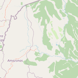
Map view of Chayu Nain Communal Reserve

Use this park location map to pinpoint Chayu Nain Communal Reserve in Peru, understand its exact geographic position, and read its mapped placement within the surrounding landscape more clearly.

Pigeon | © OpenStreetMap contributors

Location context for Chayu Nain Communal Reserve

Amazonas Region
Recorded earthquake history

Explore the Historical Earthquake Record for Chayu Nain Communal Reserve

Navigate the structured catalogue of recorded seismic events associated with the geography of Chayu Nain Communal Reserve. Use these historical records to examine past activity, epicentre distances, and magnitude details documented for the surrounding Andean-Amazon corridor without assessing current risk.

Chayu Nain Communal Reserve Earthquake History

Catalogued events

35 events

Strongest magnitude

Magnitude 5.3

Most recent event

Mar 25, 2024

This history includes earthquakes recorded inside the park or within 50 km of its borders

Park atlas

Compare regional mountain forests and connected conservation areas across the northern highlands

Parks Near Chayu Nain Communal Reserve and Surrounding Protected Landscapes

Browsing other protected areas near Chayu Nain Communal Reserve reveals wider ecological gradients across the Cordillera del Cóndor. Examining adjacent regional reserves helps place local Andean-Amazon transition habitats into a broader geographical perspective.
A watercolor illustration of layered green hills and distant mountain ridgelines, depicted in soft pastel tones against a white background.
Nature reserveSan Martin
43 km away#1 closest

East

Alto Mayo Protection Forest: Geographic Boundaries and Andean Slope Landscape Mapping

Protected watershed and cloud forest in San Martin, Peru

Spanning the eastern Andes, Alto Mayo Protection Forest functions as a foundational watershed for the Mayo River basin. This reserve preserves significant cloud forest habitats and high-gradient terrain, serving as an important link between Andean highlands and the Amazonian lowlands. Study the topographic features, hydrological network, and protected boundaries that define this crucial Peruvian wilderness.

Area
1,820 km²
Established
1987
IUCN
VI
Relief
Mountain
National parkCajamarca Region
85 km away#2 closest

Southwest

Cutervo National Park: Peru's Oldest National Park Atlas and Protected Landscape

Andean Montane Forests and Mapped Geography of a Pioneering Protected Area

As Peru's oldest national park, established in 1961, Cutervo National Park offers a unique glimpse into the protected geography of the northern Peruvian Andes. Located in the Cajamarca Region, it preserves diverse Andean montane forests and páramo grasslands across a significant elevation gradient from 1,550 to 3,500 meters. This page details the park's landscape, including its role as a headwater conservation area and its position within a critical South American ecoregion, providing rich context for geographic and protected-area exploration.

Area
82.14 km²
Established
1961
IUCN
II
Relief
Mountain
Nature reserveZamora Chinchipe
95 km away#3 closest

Northwest

Reserva Biológica Cerro Plateado: Andean and Amazonian Landscape and Protected Area Context

Vertical gradient and mountain forest geography in Zamora Chinchipe

Spanning elevations from 840 to 3,120 meters, Reserva Biológica Cerro Plateado represents a significant conservation effort within the Zamora Chinchipe province. The reserve preserves intact montane cloud forests and paramo, serving as a vital link between the eastern Andean slopes and the Nangaritza watershed in southeastern Ecuador.

Area
307.607 km²
Established
2010
IUCN
Ia
Relief
Mountain
National parkEcuador
119 km away#4 closest

Northwest

Podocarpus National Park: Ecuador's Diverse National Park and Protected Landscape

Discover elfin forests, paramo, and over 100 lagoons.

Podocarpus National Park, situated in southeastern Ecuador, stands as a prime example of a protected natural area at a unique biogeographic crossroads. This national park spans dramatic elevational zones, from montane rain forests to high-elevation paramo ecosystems dotted with more than 100 lagoons, offering rich mapped landscape exploration. Its significance lies in the convergence of four distinct ecological systems, contributing to exceptional biodiversity and a rich tapestry of natural terrain.

Area
1,462.8 km²
Established
1982
IUCN
II
Relief
Mountain
National parkZamora Chinchipe
125 km away#5 closest

Northwest

Yacurí National Park: Protected Andean Lakes and Volcanic Landscape in Zamora Chinchipe

Discover highland geography and the ancient Inca Trail.

Yacurí National Park is a key protected landscape in Ecuador's southern Andes, celebrated for its remarkable collection of over 46 high-altitude lakes set within dramatic volcanic terrain. Situated in Zamora Chinchipe province, the park preserves a vital stretch of the Inca Trail, complete with archaeological sites. This national park offers a rich exploration of Andean geography, páramo ecosystems, and significant cultural heritage, making it a cornerstone of the region's protected areas.

Area
431 km²
Established
2009
IUCN
II
Relief
Mountain
Protected areaCajamarca Region
125 km away#6 closest

Southwest

Pagaibamba Protection Forest: Geography and Protected Area Landscape Analysis

Highland Watershed Protection in the Cajamarca Andes

Pagaibamba Protection Forest represents a key protected land entity in northern Peru. Focused on maintaining the local water cycle, the area showcases dense cloud forest vegetation and steep Andean terrain. Use this mapping data to analyze its ecological boundaries, watershed significance, and regional landscape context in the Cajamarca department.

Area
20.784 km²
Established
1987
IUCN
VI
Relief
Mountain
Wildlife reserveLambayeque Region
152 km away#7 closest

Southwest

Laquipampa Wildlife Refuge: Geography and Protected Area Map of Northern Peru

Tracing the tropical dry forest boundaries of the Lambayeque Region

Laquipampa Wildlife Refuge stands as a critical protected landscape within the Lambayeque Region, preserving rare tropical dry forest ecosystems along the western Andean foothills. The refuge features a unique vertical gradient, ranging from exposed dry-forest slopes to moist highland ravines. Use this atlas resource to understand the park's mapped boundaries, diverse terrain, and central role in regional conservation.

Area
113.47 km²
Established
2006
IUCN
IV
Visitors
2K annual
Wildlife reserveCajamarca
156 km away#8 closest

Southwest

Bosques Nublados de Udima Wildlife Refuge: Protected Andean Cloud Forest and River Basin

A critical mountain reserve in the Cajamarca region of northern Peru.

Situated on the dramatic western slopes of the Andes, Bosques Nublados de Udima Wildlife Refuge protects 12,183 hectares of cloud forest ecosystem. The reserve is characterized by a sharp vertical gradient dropping over 1,000 metres toward the Zaña River basin, preserving both rare Amazonian-linked plant species and significant pre-Columbian archaeological irrigation structures.

Area
121.83 km²
Established
2011
IUCN
IV
Relief
Mountain

Common questions about visiting, size, designation, and location context for Chayu Nain Communal Reserve

Chayu Nain Communal Reserve FAQs for park facts, access, geography, and protected area context

Find quick answers about Chayu Nain Communal Reserve, including protected-area facts, park geography, trail and visitor context, and how the park fits into its surrounding country and regional landscape.
MoriAtlas Explorer

Continue Your Protected Areas Search Across the Global Atlas

Deepen your exploration by continuing the structured search for national parks and protected areas worldwide. Utilize the comprehensive filtering capabilities to compare different conservation landscapes and refine your understanding of global park geography. Discover more about the distribution and characteristics of protected natural areas.

Global natural geography
