

Mori Atlas logo
Biosphere reserveChini Lake

A complex mosaic of twelve interconnected lake basins, forested islands, and wetland margins

Chini Lake Biosphere Reserve: Mapping the Protected Freshwater Landscape in Pahang, Malaysia

Chini Lake stands as a major protected freshwater system in central Pahang, defined by a network of twelve linked lake basins nestled within lowland tropical forest. This UNESCO Biosphere Reserve serves as a critical geographic junction where river-fed channels, swampy wetland habitats, and indigenous Orang Asli settlements converge. Understanding this terrain involves examining the hydrological connection to the Pahang River and the seasonal transformation of the surface landscape.

freshwater lakeUNESCO Biosphere ReserveOrang AsliJakun communitylotus bloomslowland tropical forest
A flat-style vector illustration of a tranquil lake surrounded by a colorful forest and distant hills, with a prominent tree trunk in the foreground.

Chini Lake

Biosphere reserve

Park overview

Structured park overview, official facts, and landscape profile for Chini Lake

Chini Lake park facts, protected area profile, and essential visitor context

Review the core facts for Chini Lake, including designation, size, terrain, visitor scale, habitats, and operating context in one park-focused overview.

About Chini Lake

Chini Lake, known locally as Tasik Chini, is one of the most distinctive freshwater landscapes in Peninsular Malaysia. Located in the Pekan District of Pahang, the lake system is a chain of about twelve interconnected water bodies set within a lowland tropical catchment between Chini, Pekan, and Temerloh. Together they form the second largest natural freshwater lake complex in Malaysia, behind only Tasik Bera, and have been formally recognised as a UNESCO Biosphere Reserve under the Man and the Biosphere Programme.

The cultural identity of Chini Lake is inseparable from the Jakun Orang Asli who live on its shores and small islands. Villages such as Kampung Gumum, Kampung Cendahan, Tanjung Puput, Melai, and Ulu Melai maintain traditional relationships with the water and forest. The lake's folklore is anchored by the legend of Naga Seri Gumum, a dragon reputed to dwell in its depths, and by persistent stories of an ancient Khmer city lying beneath the surface. Folk linguistic links between the local Orang Asli dialect and the Khmer language have also drawn academic interest, supporting broader theories about ancient migration patterns through the peninsula.

Ecologically, Chini Lake is notable for its lotus flowers, which bloom across the surface during the drier months and historically turned the lake into a striking floating garden. The surrounding forest, islands, and wetlands support varied flora and freshwater fauna. However, the lake has also become a well-known case study in Malaysia of the tensions that arise when a protected freshwater ecosystem sits alongside logging, mining, plantations, and rural development. Logging and iron ore mining near Bukit Ketaya, as well as later licensing of manganese mining, have raised serious concerns about sedimentation, water quality, the loss of traditional forest resources, and the long-term viability of the biosphere reserve designation.

Conservation responses have included the 2019 gazetting of a permanent reserve forest around significant portions of the lake, the formation of monitoring teams, and in 2021 the announcement of an end to mining around the lake, addressing long-standing fears that the ecosystem could collapse. Chini Lake therefore stands at the intersection of cultural heritage, indigenous life, freshwater biodiversity, and environmental policy in Malaysia, making it far more than a scenic site alone.

Quick facts and research context for Chini Lake

Chini Lake lies in the Pekan District of central Pahang in Peninsular Malaysia, near the Pahang River. The lake system covers roughly 5,085 hectares of surface water and consists of twelve interlinked lakes. It has held UNESCO Biosphere Reserve status under the Man and the Biosphere Programme, and in March 2019, 4,498 hectares around it were gazetted as a permanent reserve forest by the Pahang state government. The lake's dispersed shoreline settlements support around 400 to 500 Orang Asli, mostly from the Jakun community, with Kampung Gumum as one of the principal villages.

Protection and recognition

Terrestrial protected area designation history established in 2009

Chini Lake Protection Status and International Recognition Record

Chini Lake features documented terrestrial protection status with an established designation year of 2009. Official records outline the conservation scope and administrative background without imported international recognitions.

Protection details

Protection scope
Terrestrial
Designated year
2009
Transboundary protection
No
Park context

Deeper park guide and search-rich context for Chini Lake

Chini Lake history, landscape, wildlife, and travel context

Explore Chini Lake through its history, landscape character, ecosystems, wildlife, conservation priorities, cultural context, and seasonal travel timing in a structured park guide built for atlas discovery and search intent.

Why Chini Lake stands out

Chini Lake is best known for its lotus blooms, which carpet the lake surface in white and pink flowers during the mid-year dry months, and for its rich cultural ties to the local Orang Asli. It is equally recognised for the legend of Naga Seri Gumum, the so-called Malaysian Loch Ness Monster, said to live in the depths of the lake alongside a mythical sunken Khmer city. Beyond folklore, the lake draws attention as a UNESCO Biosphere Reserve under pressure: a rare example in Peninsular Malaysia where indigenous settlement, freshwater biodiversity, and tropical forest converge within a formally recognised international protection framework.
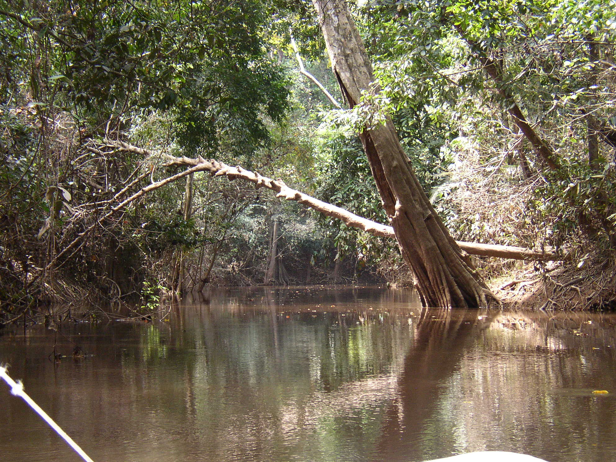
A view from water level looking into a narrow, dark channel surrounded by dense tropical forest, with a large tree leaning over the water.
A calm, narrow channel within the tropical wetlands of Chini Lake.

Chini Lake history and protected-area timeline

Chini Lake's modern history has been marked by competing pressures from development and conservation. In 2009, the lake was formally part of UNESCO's Man and the Biosphere network, alongside the Crocker Range in Sabah, making it one of only two sites in Malaysia to hold this international designation.

Over the following decade, concerns grew about logging, iron ore mining on Bukit Ketaya beside the lake, plantations belonging to RISDA, and upstream land conversion. Community leaders and public intellectuals warned that rapid environmental change could trigger an ecosystem collapse by 2030, while Transparency International cautioned that the lake risked losing its UNESCO Biosphere Reserve status. The Pahang state government countered that state health studies found water quality broadly normal, attributing visible sediment to nearby plantations.

In March 2019, 4,498 hectares around the lake were gazetted as a permanent reserve forest under the administration of the Pahang state government, a major protective milestone. In June 2021, however, a mining licence for manganese and other minerals covering over 40 hectares near the lake was granted to a company with royal Pahang family ownership, prompting criticism from conservationists who argued this contradicted the state's stated conservation commitments. Later in 2021, the government announced an end to mining around the lake, and by 2022 UNESCO's reviews noted that deforestation and intensive land conversion had already affected the site's biosphere standing.

Parallel to environmental governance, the lake's Orang Asli communities, principally Jakun, have continued their longstanding presence, and there have been state-led efforts to build chalets, new jetties, craft workshops, and homestay programmes in collaboration with village residents, recognising both the lake's tourism potential and its cultural significance.

Chini Lake landscape and geographic character

Chini Lake sits within a lowland tropical landscape in central Pahang, where dense rainforest meets a mosaic of freshwater lakes, islands, and river channels. The lake system is shaped by the surrounding catchment and the Chini River, which carries water from the lake into the much larger Pahang River. A dam on the outflow helps regulate lake depth during the dry season, although the raised water levels have contributed to shoreline tree mortality, a visible physical change in the landscape.

The broader terrain combines broad open water surfaces, gently shelving shorelines, peat-influenced wetlands, and small forested islands that break up the lake's expanse. The Bukit Ketaya hill next to the lake has historically been associated with iron ore extraction, illustrating how mineral resources and freshwater ecology share the same geographic setting. The area's mix of still water, swampy margins, and forested uplands creates a layered scenery that both defines the lake's character and underlies its ecological sensitivity to upstream land use.

Chini Lake ecosystems, habitats, and plant life

Chini Lake's natural value lies in its combination of open freshwater habitat, fringing wetlands, and lowland tropical forest. The lake system supports reported populations of freshwater fish, aquatic plants, and surrounding terrestrial flora, with the lake itself serving as both habitat and dispersal corridor across the twelve connected water bodies. The presence of permanent water year-round, partly maintained by the dam on the Chini River, sustains wetland vegetation along the margins.

Seasonally, the lake becomes an ecological stage for lotus blooms, when large numbers of white and pink lotus flowers spread across the surface and transform the open water into a dense floating garden during the drier months of the year. This recurring phenomenon, alongside the surrounding peat and forest vegetation, gives Chini Lake a distinct ecological identity within Peninsular Malaysia. The mosaic of habitats, however, is also ecologically fragile: changes in water level, sedimentation from mining, and forest clearing upstream have all had direct impacts on shoreline vegetation, including the historic dieback of lakeside trees.

Chini Lake wildlife and species highlights

Wildlife at Chini Lake reflects the wider biodiversity of Peninsular Malaysia's lowland freshwater and forest ecosystems. The lake itself is associated with a wide range of freshwater fish, as well as aquatic and semi-aquatic fauna supported by the twelve interconnected lake basins. The surrounding forest sustains non-aquatic wildlife drawn from the regional tropical forest community, contributing to the lake's broader ecological character.

Beyond aquatic life, the lotus blooms that carpet the lake surface during the dry season not only define the visual identity of the site but also shape its ecological dynamics, supporting pollinators and other organisms tied to the lake's seasonal cycle. Local communities have long noted the lake as a source of fish for subsistence, although fish catches have reportedly declined in quality and availability as environmental pressures have increased. The lake's wildlife significance is therefore tightly bound to the health of its water, forest, and shoreline habitats.

Chini Lake conservation status and protection priorities

Chini Lake holds a unique conservation position in Malaysia as one of only two UNESCO Biosphere Reserves in the country, alongside the Crocker Range in Sabah. Biosphere Reserve status places the lake within an international framework that balances ecological preservation, research, and sustainable use, and recognises the site's combined importance for freshwater ecosystems, tropical forest, and indigenous cultural heritage.

Conservation efforts at Chini Lake have been shaped by persistent conflict with industrial and agricultural pressures. Logging, iron ore mining on Bukit Ketaya, and the later licensing of manganese mining have all raised concerns about sedimentation, water quality decline, and disruption to traditional forest use by Orang Asli communities. The gazetting of 4,498 hectares as a permanent reserve forest in March 2019 was a key formal protection step, reinforced in 2021 by a government announcement halting mining around the lake.

At the same time, the lake's conservation status remains a source of debate. By 2022, UNESCO's own reviews found that observed deforestation and intensive land conversion had diminished the lake's standing within its biosphere framework, illustrating how international recognition alone does not guarantee ecological security. Monitoring teams, state pollution studies, and community-driven programmes continue to attempt to reconcile the lake's protected status with the livelihoods of surrounding Orang Asli and broader development pressures in central Pahang.

Chini Lake cultural meaning and human context

Chini Lake is strongly tied to the cultural identity of the Jakun Orang Asli, the indigenous peoples of Peninsular Malaysia who inhabit its shores and small islands. Communities such as Kampung Gumum, Kampung Cendahan, Tanjung Puput, Melai, and Ulu Melai maintain traditional practices connected to fishing, forest resource use, and local medicine, and their language has drawn academic interest because of its possible historical links to Khmer, supporting theories of ancient northward-to-southward migration across Southeast Asia.

The lake is also defined by highly visible folklore. According to Orang Asli legend, the waters are home to a dragon called Naga Seri Gumum, sometimes referred to as Malaysia's own Loch Ness Monster. Local tradition also holds that an ancient Khmer city lies submerged beneath the lake, a story that has fuelled both popular imagination and modern research efforts, though such projects have not been completed. Together, the indigenous presence and these layered legends give Chini Lake a cultural depth that goes well beyond its natural setting.

Top sights and standout views in Chini Lake

Few sites in Malaysia combine a UNESCO Biosphere Reserve designation, an indigenous Jakun Orang Asli community, and internationally referenced folklore within a single freshwater landscape, and Chini Lake is one of them. Its twelve interconnected lake basins, set in lowland tropical forest near the Pahang River, offer a distinctive combination of open water, forested islands, and culturally rooted shoreline settlements.

The lake's signature seasonal phenomenon, the blooming of thousands of white and pink lotus flowers across the water surface during the drier months, remains one of its most distinctive visual highlights. Combined with the legend of Naga Seri Gumum and the broader story of indigenous resilience against environmental pressure, Chini Lake stands as a place where ecology, mythology, and community history intersect.

Best time to visit Chini Lake

The most distinctive time to experience Chini Lake is during the drier months of the year, particularly June through September, when lotus flowers spread across the water surface in white and pink blooms and the lake becomes its most visually recognisable floating garden. Outside of this lotus season, drier weather generally provides calmer conditions and clearer views across the lake system, while the surrounding wet season can raise water levels, increase sediment runoff, and alter the appearance of the shoreline.

Because the lake's character shifts so strongly with the seasons, visitors interested in experiencing the lake's signature lotus phenomenon, as well as its quieter forested and cultural landscapes, will find the mid-year window especially rewarding. Travellers focused more on cultural and community engagement with the Orang Asli villages around Chini may find that the village rhythm and accessibility are less tied to the lotus bloom itself, and any visit benefits from awareness of the lake's environmental sensitivity and ongoing conservation context.

Monthly climate preview

Long-term representative temperature ranges and monthly precipitation patterns

Chini Lake Climate Normals and Measured Weather by Month in Pahang

Historical NASA Power records track monthly temperature averages alongside precipitation totals across the representative coordinate. Exploring the complete twelve-month climatology profile reveals detailed shifts in temperature and rainfall rhythm.
Annual mean26 °C
25 °C28 °C
Jan25°
Feb25°
Mar26°
Apr27°
May28°
Jun27°
Jul27°
Aug26°
Sep27°
Oct27°
Nov26°
Dec26°
Warmest month
May

27.6 °C

Coolest month
January

25.2 °C

Wettest month
December

16.4 mm/day

Driest month
February

4.5 mm/day

Park location guide

Geography guide, regional context, and park location map for Chini Lake

Chini Lake park geography, regions, and map view in Malaysia

Understand where Chini Lake sits in Malaysia through a broader geographic reading of the surrounding landscape, nearby location context, and its mapped position within the national park landscape.

How Chini Lake fits into Malaysia

Malaysia is a federal constitutional monarchy located in Southeast Asia. The country consists of 13 states and three federal territories, divided by the South China Sea into Peninsular Malaysia on the Indochinese Peninsula and East Malaysia on the island of Borneo. With a population of over 34 million, it achieved independence from Britain in 1957 and became a modern federation in 1963. The country is recognized for its multicultural population, tropical climate, and significant economic role in the region.

Wider geography shaping Chini Lake in Malaysia

Malaysia occupies a strategic position in Southeast Asia, split by the South China Sea into two distinct regions. Peninsular Malaysia lies on the Indochinese Peninsula, sharing a land border with Thailand to the north and maritime borders with Singapore, Vietnam, and Indonesia. East Malaysia occupies the northern portion of Borneo, sharing land borders with Brunei and Indonesia, and maritime borders with the Philippines and Vietnam. The country's terrain includes coastal plains, mountain ranges such as the Titiwangsa in the peninsula, and extensive tropical rainforests.

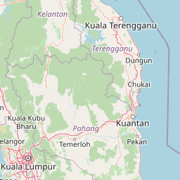
Map view of Chini Lake

Use this park location map to pinpoint Chini Lake in Malaysia, understand its exact geographic position, and read its mapped placement within the surrounding landscape more clearly.

Pigeon | © OpenStreetMap contributors

Location context for Chini Lake

Pahang

Visual reference of wetland habitats and protected forest terrain

Chini Lake Photos and Landscape Scenery Exploration

Visual records capture the interconnected water basins, wetland margins, and lowland tropical forest defining Chini Lake. Photographic documentation reveals the seasonal lotus blooms and shoreline terrain that shape this protected freshwater environment.

A view from water level looking into a narrow, dark channel surrounded by dense tropical forest, with a large tree leaning over the water.

A wide view of Chini Lake showing dark, calm water in the foreground and tree-covered hills in the background under a hazy sky.

Park atlas

Compare regional wetland habitats and lowland tropical forest reserves

Explore Parks Near Chini Lake and Surrounding Protected Natural Areas

Browse protected areas and river-fed ecosystems situated near Chini Lake in Peninsular Malaysia. Comparing these neighboring natural landscapes reveals broader regional biodiversity patterns and regional conservation priorities.
Nature reserveMalaysia
About 84 km away#1 closest

Southwest

Pasoh Forest Reserve: Lowland Dipterocarp Protected Area in Peninsular Malaysia

Mapping tropical rainforest boundaries and ecological research zones

Situated in the interior of Peninsular Malaysia, Pasoh Forest Reserve protects a vital fragment of lowland dipterocarp rainforest. The reserve is globally recognized for its long-term forest dynamics plot, which tracks hundreds of thousands of trees to inform modern understanding of rainforest ecology. The mapped landscape displays clear boundaries between the dense protected forest and surrounding agricultural plantations, offering a distinct view of land use and tropical conservation.

Area
24.5 km²
Established
1987
Relief
Upland
Scope
Terrestrial
Wildlife reservePahang
About 88 km away#2 closest

West

Tengku Hassanal Wildlife Reserve: Protected Forest and Mountain Geography in Pahang

Mapping a vast lowland dipterocarp forest sanctuary.

Spanning over 600 square kilometers, Tengku Hassanal Wildlife Reserve stands as a core protected area within Pahang. Its landscape includes riverine valleys and the steep montane terrain of the Benom Complex, supporting unique biodiversity and active wildlife conservation. This overview traces the park's geographic footprint and its role as an ecological corridor within the broader Titiwangsa mountain system.

Area
605.52 km²
Established
1923
Relief
Mountain
Climate
Tropical
National parkJohor
About 102 km away#3 closest

South

Endau-Rompin National Park: Ancient Tropical Rainforest Protected Landscape in Johor, Malaysia

Explore unique mapped geography and ancient geological features.

Endau-Rompin National Park in Johor, Malaysia, is a testament to Earth's ancient history, housing tropical rainforests built upon geological formations around 248 million years old. This protected area offers a detailed look at rugged mountainous terrain, vital river systems, and a diverse mapped landscape, crucial for understanding regional geography and conservation. Its status as one of the oldest rainforest complexes makes it a significant site for exploring the planet's prehistoric natural heritage and protected land distribution.

Area
870 km²
Established
1993
IUCN
II
Relief
Mountain
State or regional parkSelangor
About 136 km away#4 closest

West

Selangor State Park: Protected Rainforest and Geological Landscape Discovery

Highland water catchment and quartz ridge geography in Selangor

Selangor State Park forms a massive block of continuous tropical rainforest serving as the principal water supply for the Klang Valley. This protected area features rugged slopes, diverse river basins, and the dramatic 14-kilometer Klang Gates Quartz Ridge. Use this map-integrated record to understand the park's critical role in regional hydrological regulation and its significance as a research-anchored highland ecosystem.

Area
914.41 km²
Established
2007
Relief
Highland
Climate
Tropical
Nature reserveSelangor
About 143 km away#5 closest

West

Templer Park: Protected Hill Forest Reserve and Landscape Geography in Selangor, Malaysia

Mature forest canopy and tropical stream terrain

Templer Park preserves a critical patch of mature lowland and hill forest within Selangor. Featuring multi-tiered waterfalls, shaded riverbanks, and limestone caves, the reserve supports high biological interest including rare endemic species. Its mapped boundaries reflect an essential green refuge amidst regional development, offering a window into the natural forest geography north of Kuala Lumpur.

Area
12.14 km²
Established
1954
Relief
Upland
Climate
Tropical
National parkPahang
About 149 km away#6 closest

North

Taman Negara National Park: Pahang Protected Area with Mapped Boundaries for Geographic Discovery

Explore the unique landscape context within Pahang, Malaysia.

Delve into Taman Negara National Park, a significant protected area situated in Pahang, Malaysia. This detailed view highlights the park's mapped boundaries and its contribution to the regional geography. Understand the protected landscape and its place within the natural terrain of Peninsular Malaysia, essential for atlas-based geographic exploration.

Area
4,343 km²
Established
1938
IUCN
II
Relief
Mixed relief
A watercolor painting showing layers of soft green and pink rolling hills, with a line of trees in the midground and an open, flat foreground.
Protected areaJohor
About 155 km away#7 closest

Southeast

Rawa Island Protected Area: Coastal Geography and Island Landscape Context in Johor

A protected coral island within the Johor archipelago

Rawa Island serves as a significant protected landscape off the coast of Johor, Malaysia. Defined by its sharp contrast between rocky cliffs and clear, coral-filled waters, the island represents a crucial node in regional island geography. Delve into the spatial characteristics and environmental features of this South China Sea destination through our map-driven atlas framework.

Area
0.23 km²
Water
Water-dominated
A minimalist watercolor illustration depicting abstract green rolling hills and distant pink-toned ridges against a white background.
Wildlife reservePahang
About 156 km away#8 closest

Southeast

Pulau Tioman Wildlife Reserve: Mapping Island Rainforests and Marine Boundaries

Protected island geography within the Pahang region

Covering the forested interior of Tioman Island, this wildlife reserve protects lowland and hill rainforest habitats that rise to Gunung Kajang. The area serves as a significant conservation landscape, bridging remote inland mountain terrain with vibrant coral-fringed coastlines in the South China Sea.

Area
136 km²
Established
1972
Relief
Mountain
Climate
Tropical

Common questions about visiting, size, designation, and location context for Chini Lake

Chini Lake FAQs for park facts, access, geography, and protected area context

Find quick answers about Chini Lake, including protected-area facts, park geography, trail and visitor context, and how the park fits into its surrounding country and regional landscape.
MoriAtlas Explorer

Continue Your Protected Areas Search Across the Global Atlas

Deepen your exploration by continuing the structured search for national parks and protected areas worldwide. Utilize the comprehensive filtering capabilities to compare different conservation landscapes and refine your understanding of global park geography. Discover more about the distribution and characteristics of protected natural areas.

Global natural geography