
Mori Atlas logo
Protected areaComanche National Grassland

Tracing the geological corridors and prairie ecosystems of southeastern Colorado protected lands

Comanche National Grassland: An Atlas of Protected Shortgrass Prairie and Canyon Landscapes

Comanche National Grassland encompasses a vast stretch of protected shortgrass prairie and incised canyon systems across southeastern Colorado. This geographic database tracks the unique landscape transitions from open steppe to the deep, river-cut terrain of the Purgatoire and Carrizo watersheds. Researchers and enthusiasts can examine the intersection of high-plains ecology, prehistoric paleontological sites, and significant cultural history preserved within these federal boundaries.

shortgrass prairiesteppenational grasslandcanyonspinyon juniper woodlandriparian habitat
A stylized vector illustration showing a cracked asphalt road with puddles in the foreground, leading through a green pine forest towards a tall waterfall cascading down pink and yellow cliffs under a pastel sky.

Comanche National Grassland

Protected area

Park overview

Structured park overview, official facts, and landscape profile for Comanche National Grassland

Comanche National Grassland park facts, protected area profile, and essential visitor context

Review the core facts for Comanche National Grassland, including designation, size, terrain, visitor scale, habitats, and operating context in one park-focused overview.

About Comanche National Grassland

Comanche National Grassland is a sizable National Grassland in the southeastern plains of Colorado, where it preserves an unusual combination of open shortgrass prairie and sheltered sandstone canyons. Stretching across three counties, Baca, Otero, and Las Animas, it sits in a transition zone between the Great Plains and the foothills that mark the western edge of the Arkansas River drainage. The nearest city is La Junta, and the grassland is also paired geographically and administratively with Cimarron National Grassland just across the border in Kansas.

The land is organized into two main units that are physically separated by significant distances. The Timpas Unit lies south of La Junta and is shaped largely by the Purgatoire River, also known historically as the Purgatory or Picketwire River, while the Carrizo Unit lies further south near Springfield and follows the watershed of Carrizo Creek toward the Cimarron River. Private ranch inholdings are interspersed throughout the federally owned land, and the area remains an active working landscape under grazing permits issued by the Forest Service.

Ecologically, the grassland ranges from rolling uplands of steppe and shortgrass prairie to cooler, more sheltered canyon bottoms where moisture supports denser growth. Pinyon and juniper cling to rocky canyon walls, while cottonwoods and willows line the streams. The semi-arid climate and elevation extremes create strong seasonal contrasts, with hot summers and notably cold winters in places such as Fallas Mesa.

Comanche's significance extends well beyond its scenery. The Timpas Unit contains the Purgatoire River track site, one of the largest known dinosaur trackways in the world, set in a canyon more than 400 feet deep. The grassland also preserves an exceptional record of human history, from prehistoric hunting-and-gathering cultures and 1,000-year-old agricultural experiments to Apache, Comanche, and Spanish-era transitions, and ultimately to nineteenth-century ranching along the Santa Fe Trail. The Rourke Ranch and the Dolores Mission in Picketwire Canyon, along with ancient petroglyph galleries like those in Picture Canyon, anchor the grassland's identity as both a natural and a cultural landscape. The site is administered together with the Pike and San Isabel National Forests under common Forest Service leadership, which keeps management linked across Colorado's southern plains and southern mountains.

Quick facts and research context for Comanche National Grassland

Comanche National Grassland is located in southeastern Colorado, covering land across Baca, Otero, and Las Animas counties and is centered around the regional hub of La Junta. The protected area was formally established on June 23, 1960 and is managed by the United States Forest Service, which also oversees the adjoining Cimarron National Grassland in Kansas.

The landscape is organized into two units, Timpas and Carrizo, with elevations ranging from roughly 3,900 feet along the Oklahoma border to about 6,200 feet on Fallas Mesa. Climate is semi-arid, with annual precipitation between roughly 12 and 17 inches and pronounced swings between hot summers and cold winters. The grassland pairs extensive shortgrass prairie with sheltered canyon systems that hold most of the park's cultural and natural highlights.

Protection and recognition

Documented management scope and official recognition framework

Comanche National Grassland Protection Status and Terrestrial Designation

Comanche National Grassland maintains a terrestrial protection scope within its designated conservation boundaries. Official records organize administrative status and territorial management metrics for geographic reference.

Protection details

Protection scope
Terrestrial
Transboundary protection
No
Park context

Deeper park guide and search-rich context for Comanche National Grassland

Comanche National Grassland history, landscape, wildlife, and travel context

Explore Comanche National Grassland through its history, landscape character, ecosystems, wildlife, conservation priorities, cultural context, and seasonal travel timing in a structured park guide built for atlas discovery and search intent.

Why Comanche National Grassland stands out

Comanche National Grassland is best known for its blend of shortgrass prairie and deeply cut canyon country, particularly the Purgatoire River canyon system in the Timpas Unit. Picketwire Canyon holds one of the largest dinosaur track sites in the world, with more than 1,300 brontosaur and allosaur prints preserved in the Morrison Formation and accessible along a long foot, bike, and horseback trail. The grassland is also recognized for its rich Native American and frontier-era rock art. Petroglyphs in sites such as Picture Canyon can be thousands of years old, with one cave aligning with the spring and fall equinox sunrises. Combined with surviving Santa Fe Trail remnants and the historic Rourke Ranch, Comanche is valued as much for its cultural and paleontological record as for its open plains ecology.
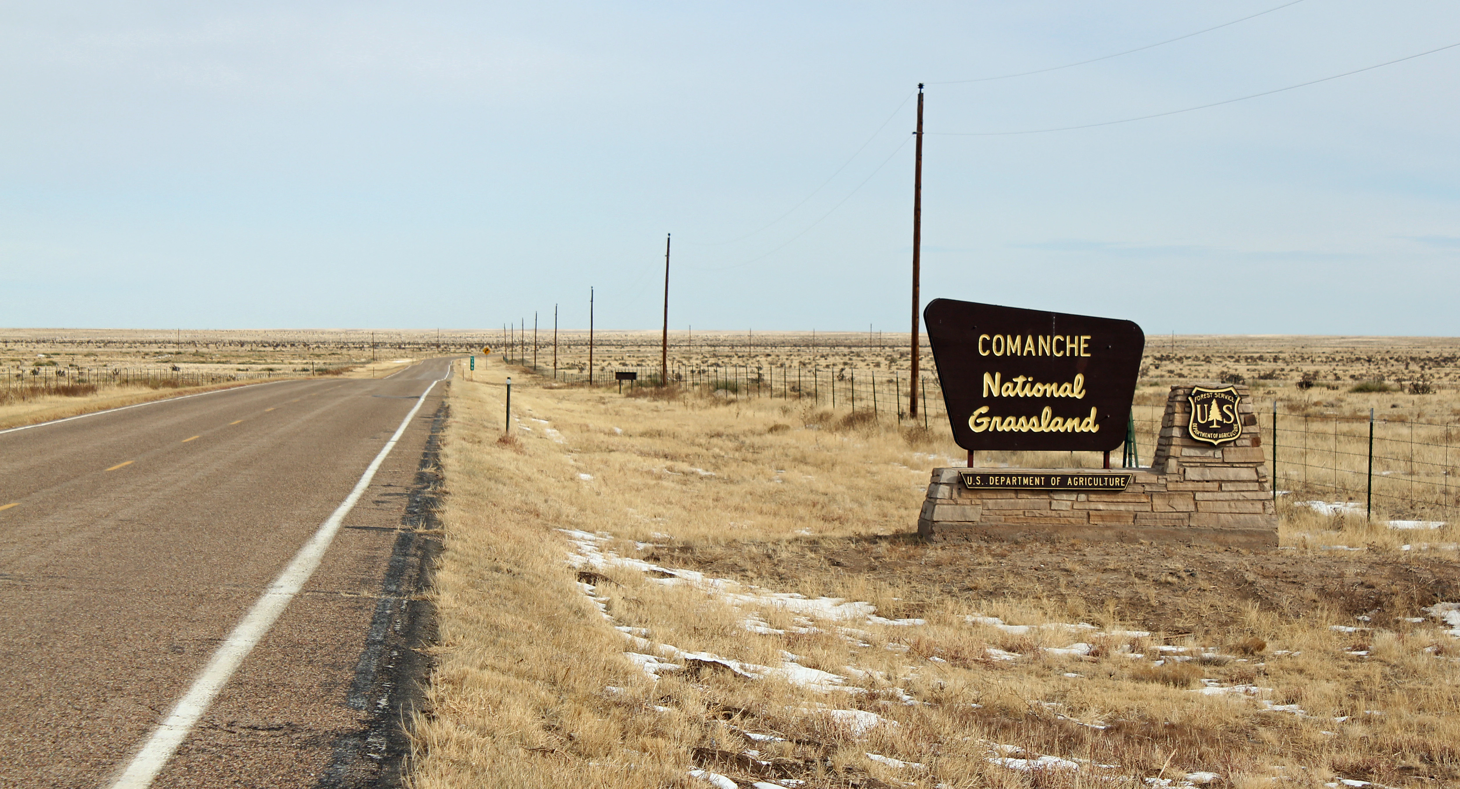
A large brown sign reading 'Comanche National Grassland' stands beside a paved road stretching into a flat, grassy landscape with patches of snow.
View of the entrance sign for Comanche National Grassland along a highway.

Comanche National Grassland history and protected-area timeline

The human history of Comanche National Grassland extends back thousands of years. Early inhabitants used the canyons as rock shelters and left petroglyphs on cliff faces and boulders across the area, with some of the imagery potentially dating back as far as 8,000 years and some showing the horses that arrived with the Spanish in the 1500s. Around 1000 AD, a people known as the Apishipa attempted farming in the region without lasting success. Apache groups occupied the area when Spanish explorers arrived, but they were pushed southward by the Comanche during the eighteenth century, leaving behind tipi rings and other traces of their presence across the plains.

During the 1800s, the Santa Fe Trail cut across the Timpas Unit, and from the 1820s onward wagon trains from Missouri and Kansas rolled through the future grassland bound for New Mexico. After the Civi War era, New Mexican families began settling along the Purgatory River in 1871, and shortly afterward Eugene and Mary Rourke established their ranch nearby, the forerunner of the historic Rourke Ranch that still stands within the grassland. Homesteaders followed the early ranchers, and the area became heavily devoted to broomcorn cultivation.

That agricultural era collapsed during the Dust Bowl of the 1930s, when drought and soil loss bankrupted many families and forced the sale of their lands. The federal government acquired these failed homesteads, and on June 23, 1960, the area was formally established as Comanche National Grassland under U.S. Forest Service management. Grazing permits for cattle have remained a central part of its working landscape identity since the beginning of federal protection.

In 1991, the U.S. Army transferred 16,000 acres along the Purgatoire River Canyon from the Piñon Canyon Maneuver Site into the grassland, enriching the protected area with additional canyon scenery and wildlife habitat. In 2007, the Army proposed a major expansion of that same maneuver site that could have absorbed most of the grassland and displaced thousands of residents across southeastern Colorado. After years of local opposition, the Army formally cancelled the Piñon Canyon expansion plan in November 2013, securing the grassland's continued status as a National Grassland.

Comanche National Grassland landscape and geographic character

Comanche National Grassland occupies a broad sweep of southeastern Colorado where the Great Plains roll toward breaks cut by rivers and creeks. The topography mixes gentle uplands with sudden drops into steep-walled canyons. Elevations run from roughly 3,900 feet at the southeastern corner of the Carrizo Unit along the Oklahoma border up to about 6,200 feet on Fallas Mesa in the northwestern part of the same unit.

The Timpas Unit is defined by the Purgatoire River and its tributaries, which have carved incised canyons such as Picketwire and Vogel, both offering stony cliffs, mesa tops, and seasonal springs. Picketwire Canyon in particular is about 400 feet deep and forms a dramatic geological corridor through the uplands. The Carrizo Unit, by contrast, follows the Carrizo Creek watershed as it flows toward the Cimarron River, and includes canyons like Picture Canyon, Carrizo Canyon, and Cottonwood Canyon, which combine rugged walls with springs and riparian growth.

Climate shapes the landscape as much as geology. The area is semi-arid, with annual precipitation ranging from around 12 inches near La Junta to roughly 17 inches around Springfield. Summers are hot and winters cold, producing a continental grassland climate that emphasizes resilient native grasses over woody vegetation across most of the uplands, while concentrating denser plant life into the cooler, moister canyon bottoms.
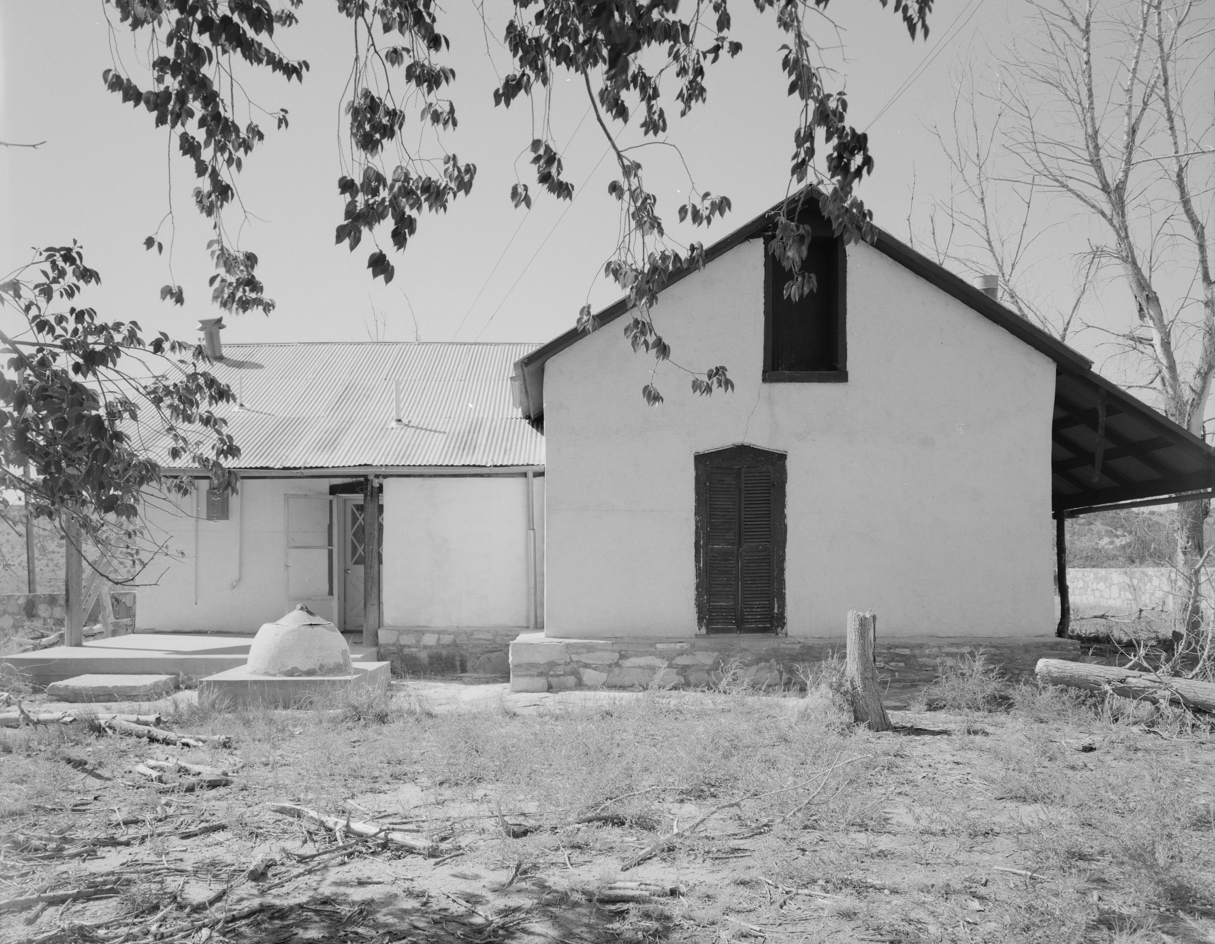
Black and white photograph of the front facade of a historic ranch house with a gabled roof and dark door, surrounded by trees.
Front facade of the 1875 residence at Rourke Ranch Historic District in Comanche National Grassland, Colorado.

Comanche National Grassland ecosystems, habitats, and plant life

The grassland's natural character is dominated by steppe vegetation and shortgrass prairie, the classic plant communities of the southern Great Plains. Across the open uplands, native grasses and forbs prevail, with scattered shrubs such as Chickasaw plum and fragrant mimosa adding seasonal diversity. The repeated message of the landscape is one of drought-adapted grassland rather than forest.

Where streams and canyons interrupt the prairie, the ecological picture changes. Pinyon and juniper grow along rocky canyon walls, while cottonwoods and willows form green ribbons along permanent watercourses. Western soapberry and netleaf hackberry are common along some canyon bottoms, occasional stands of Gambel oak appear where moisture is sufficient, and a few ponderosa pines cling to shaded, cool hillsides. Together these canyon microhabitats create ecological islands of tree and shrub cover amid the surrounding prairie sea.

The watershed framework supports this diversity. The Timpas Unit is organized around the Purgatoire River, bringing riparian vegetation and gallery-style habitats into the canyons, while the Carrizo Unit is structured by Carrizo Creek and its springs, sustaining both aquatic and riparian life. The combination of exposed uplands and sheltered canyons gives Comanche a layered ecological character unusual for a National Grassland, with related conservation going beyond simply preserving open grass.

Comanche National Grassland wildlife and species highlights

Wildlife at Comanche is shaped by the open prairie and the sheltered canyons, and includes both wide-ranging plains species and creatures tied to the canyon's rocky environments. Pronghorn, mule deer, and elk move across the uplands, while prairie dogs occupy their characteristic colonies. Wild turkey inhabits the areas where trees and brush provide cover, and golden eagles soar over the open landscape.

Smaller, sometimes less conspicuous species are also part of the fauna. Swift fox is among the predators adapted to the shortgrass, and roadrunners appear only occasionally through the grasslands. Bird diversity is unusually rich for a grassland: roughly 328 bird species have been documented in Baca County alone, including many eastern species reaching the western edge of their range.

Cottonwood Canyon in the Carrizo Unit is regarded as one of the best birding areas in Colorado, drawing birders because of its combination of riparian habitat and prairie-edge mosaics. The grassland also hosts Colorado's only publicly accessible lesser prairie chicken lek at Campo, although the displayed ground is often closed because of declines in the species. In late summer and early fall, male tarantulas emerge from their burrows beginning around September to seek out females, and the resulting crossings of public roads have become a small but well-known spectacle of the area.

Comanche National Grassland conservation status and protection priorities

Comanche National Grassland is one of the designated National Grasslands within the U.S. National Forest System, managed by the Forest Service as part of a broader landscape that includes Pike and San Isabel National Forests and Kansas's Cimarron National Grassland. The protected designation, which took formal effect in 1960, was itself a kind of conservation outcome: the land had been abandoned during the Dust Bowl of the 1930s and was acquired by the federal government from bankrupt homesteaders before being consolidated into a single managed grassland.

The conservation value of the area lies in both its prairies and its canyons. Preserving semi-arid shortgrass steppe protects a Great Plains ecosystem type that has been widely altered by cultivation and development, while the canyons shelter pinyon, juniper, riparian woodland, and oak communities that complement the open uplands. The presence of significant paleontological resources, including the dinosaur trackways of Picketwire Canyon, gives the area a scientific importance that goes beyond its modern ecology.

Lesser prairie chicken habitat at the Campo Lek gives the grassland a specific role in the conservation of a species that has declined across much of its range. The 1991 transfer of 16,000 acres from the Piñon Canyon Maneuver Site added canyon wildlife habitat to the protected area, and the eventual cancellation of the proposed major expansion of that maneuver site in 2013 preserved the integrity of the grassland against a large-scale land transfer to military use. Grazing management under federal permits continues to shape how conservation objectives balance with the area's working landscape character.

Comanche National Grassland cultural meaning and human context

Comanche National Grassland preserves an unusually deep cultural record for a grassland landscape, beginning with prehistoric Native American rock art that can be thousands of years old and continues through the era of Plains tribes and the arrival of Euro-Americans. The petroglyph vocabulary includes both very ancient imagery and more recent figures showing horses, evidence of the cultural transitions that took place after the Spanish brought horses north into the Southwest in the 1500s. Tipi rings scattered across the uplands are reminders of more recent Plains cultures, particularly Comanche presence in the area after pushing Apache groups southward in the 1700s.

The Santa Fe Trail era is the next major cultural layer. A branch of the trail runs through the Timpas Unit, and stone posts preserve sections of the route between overlooks such as Sierra Vista and the Timpas Picnic Area. Nineteenth-century settlements followed, including the New Mexican families who arrived along the Purgatory River in 1871 and the founding of the Rourke Ranch in the same period. The Rourke Ranch and the Dolores Mission in Picketwire Canyon remain visible reminders of that homesteading and ranching era.

More recently, the cultural context of the grassland has also been shaped by debates over the proposed expansion of the Piñon Canyon Maneuver Site, which would have absorbed large parts of southeastern Colorado had it not been cancelled in 2013. That history ties the grassland directly to the broader story of land use and rural identity across the southern Great Plains.

Top sights and standout views in Comanche National Grassland

The Purgatoire River track site in Picketwire Canyon, one of the largest dinosaur trackways in the world, is a defining feature of Comanche National Grassland, with thousands of brontosaur and allosaur prints from the Morrison Formation set within an 8.7-mile canyon trail. Along the same trail, the historic Dolores Mission and Rourke Ranch connect prehistoric geology with nineteenth-century ranching heritage.

In the Carrizo Unit, Picture Canyon offers extensive petroglyphs and a special equinox-aligned cave, Crack Cave, where sunlight briefly illuminates key images during spring and fall. Cottonwood Canyon stands out for birding, while Vogel Canyon in the Timpas Unit pairs easy mesa-top walks with hidden springs and rock art. Across all of this, the unbroken sweep of shortgrass prairie gives the cultural and natural sites a striking, wide-open setting.

Best time to visit Comanche National Grassland

The character of Comanche National Grassland shifts clearly with the seasons, and visitors with different interests may favor different windows. Spring and fall are generally the most comfortable periods for hiking and for visiting places like Vogel Canyon, Picture Canyon, and the Santa Fe Trail historic sites; cooler temperatures make the multi-mile trails through Picketwire Canyon far more manageable, and ranger-led vehicle tours into the canyon have historically been offered on weekends during these seasons.

Summer can be brutally hot, particularly in the open prairie uplands of both units, with daytime highs well above 90 degrees Fahrenheit. Winter brings cold air and occasional snow, with average January lows dropping below 20 degrees Fahrenheit and freezing conditions shaping access to remote or canyons roads. Late summer into early fall has its own appeal because of the tarantula emergence that begins around September, when males are often visible crossing roads and trails.
Monthly climate preview

Long-term representative point measurements of monthly temperature and precipitation rhythms

Comanche National Grassland Climate Normals and Annual Weather by Month

Comanche National Grassland climate normals document a measured range of average monthly temperatures from 1.34 degrees Celsius to 25.91 degrees Celsius alongside recorded precipitation patterns from 0.33 to 2.14 millimeters per day. Reviewing the complete twelve month profile provides detailed context on long-term thermal variations and precipitation distribution across the protected landscape.
Annual mean13 °C
1 °C26 °C
Jan
Feb
Mar
Apr12°
May18°
Jun24°
Jul26°
Aug24°
Sep20°
Oct13°
Nov
Dec
Warmest month
July

25.9 °C

Coolest month
December

1.3 °C

Wettest month
July

2.1 mm/day

Driest month
January

0.3 mm/day

Park location guide

Geography guide, regional context, and park location map for Comanche National Grassland

Comanche National Grassland park geography, regions, and map view in United States of America

Understand where Comanche National Grassland sits in United States of America through a broader geographic reading of the surrounding landscape, nearby location context, and its mapped position within the national park landscape.

How Comanche National Grassland fits into United States of America

The United States of America is a federal presidential republic and one of the world's largest countries by area and population. It consists of 50 states across a vast territory spanning multiple time zones, with its capital in Washington, D.C. and largest city in New York City. The nation has a diverse economy, influential political system, and significant cultural and military presence globally.

Wider geography shaping Comanche National Grassland in United States of America

The United States occupies a vast territory in North America, bordered by Canada to the north and Mexico to the south. The 48 contiguous states stretch from the Atlantic to the Pacific Ocean, while Alaska occupies the northwestern region and Hawaii is an archipelago in the Pacific. The country encompasses diverse terrain including the Rocky Mountains, Appalachian Mountains, Great Plains, and extensive river systems.

Map view of Comanche National Grassland

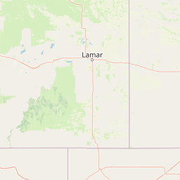
Use this park location map to pinpoint Comanche National Grassland in United States of America, understand its exact geographic position, and read its mapped placement within the surrounding landscape more clearly.

Pigeon | © OpenStreetMap contributors

Location context for Comanche National Grassland

Colorado
Recorded earthquake history

Review the Historical Earthquake Catalogue for Comanche National Grassland

Browse the documented seismic history associated with the geography of Comanche National Grassland. This structured record provides details on past earthquake activity for those examining the regional seismic profile and historical data surrounding this protected landscape through MoriAtlas.

Comanche National Grassland Earthquake History

Catalogued events

7 events

Strongest magnitude

Magnitude 3.8

Most recent event

Sep 13, 2021

This history includes earthquakes recorded inside the park or within 50 km of its borders

Visual reference for shortgrass prairie terrain and deep canyon habitats

Comanche National Grassland Landscape and Scenery Photography Gallery

Comanche National Grassland photos reveal the wide open shortgrass prairie and deep river canyons defining southeastern Colorado. Protected area views highlight dramatic rock formations, pinyon juniper woodlands, and remote terrain characteristics.

A large brown sign reading 'Comanche National Grassland' stands beside a paved road stretching into a flat, grassy landscape with patches of snow.

A series of large, deep fossilized dinosaur footprints embedded in a light gray limestone rock surface, some filled with water, leading toward a dry grassland landscape with rocky hills and blue sky in the background.

Black and white photograph of the front facade of a historic ranch house with a gabled roof and dark door, surrounded by trees.

Park atlas

Compare regional canyon landscapes, shortgrass steppe habitats, and neighboring reserves.

Parks Near Comanche National Grassland and Surrounding Protected Areas

Browsing other protected areas near Comanche National Grassland reveals broader regional connections across the shortgrass prairie and deeply cut river canyons of southeastern Colorado. Comparing these adjacent reserves provides valuable geographical context for understanding the wider steppe ecosystems and protected landscapes of the American plains.
A pale, soft watercolor illustration of a wide, open prairie with gentle rolling hills in the background, low shrubs, and grasses in the foreground.
Protected areaKansas
24 km away#1 closest

East

Cimarron National Grassland: Mapping the Largest Protected Area in Kansas

Shortgrass prairie geography and historical riparian landscapes

Spanning over 100,000 acres in southwestern Kansas, Cimarron National Grassland serves as a major ecological refuge within the Great Plains. The protected area features a unique terrain characterized by sand sagebrush uplands, cottonwood-forested bottomlands, and the winding course of the Cimarron River. This mapping data highlights the intersection of modern wildlife conservation and the remnants of the historic Santa Fe Trail.

Area
437.77 km²
Established
1960
Relief
Upland
Climate
Arid
A horizontal watercolor illustration of a wide, open prairie landscape featuring soft green hills, sparse shrubs, and grasses against a pale background.
Protected landscapeNew Mexico
36 km away#2 closest

South

Kiowa National Grassland: Protected Landscapes, Canyon Terrain, and Prairie Geography

Northeastern New Mexico shortgrass prairie and river canyon systems.

Kiowa National Grassland represents a distinctive protected landscape within the southwestern Great Plains, featuring a mix of rolling steppe, pinyon-juniper woodland, and the deep gorges of the Canadian River Canyon. This area offers significant insight into the regional geography of New Mexico, where historic Santa Fe Trail corridors and seasonal playa lakes define the local terrain and ecosystem.

Area
554.95 km²
Established
1960
Relief
Upland
Climate
Temperate
A horizontal watercolor painting showing a soft, stylized view of open, rolling grassland under a hazy sky, with yucca-like plants in the foreground.
Wildlife reserveTexas
46 km away#3 closest

Southeast

Rita Blanca National Grassland: Protected Shortgrass Prairie Geography and Map

Mapping the mosaic of federal lands in the Texas Panhandle

Rita Blanca National Grassland offers a detailed look at restored shortgrass prairie ecosystems within the southern Great Plains. The area consists of intermixed federal and private land parcels that define the regional geography of the Texas and Oklahoma borderlands. This protected landscape provides habitat for pronghorn, prairie dogs, and raptors across a semi-arid, gently sloping terrain.

Area
376.31 km²
Established
1960
Relief
Upland
Climate
Arid
Watercolor painting of a serene mountain landscape featuring rolling hills, coniferous trees, and a lake in the foreground, rendered in light pastel tones.
Protected landscapeColorado
78 km away#4 closest

West

San Isabel National Forest: Geographic Overview and Protected Mountain Landscape Atlas

Central Colorado alpine terrain and designated wilderness areas

Spanning eleven counties in central Colorado, San Isabel National Forest serves as a cornerstone of the Southern Rocky Mountains. The forest landscape is dominated by the Sawatch and Sangre de Cristo ranges, offering a unique atlas of alpine tundra, dense coniferous forests, and high-altitude peaks that define the character of the region. This protected area provides a vital habitat and a vast, rugged environment characterized by volcanic formations like the Spanish Peaks and glacial geological features.

Area
4,533.42 km²
Established
1902
Relief
Mountain
Climate
Alpine
A soft watercolor illustration depicting a simplified, layered landscape of rolling hills and distant mountains in shades of light green, pale yellow, and soft pink.
Protected areaColorado
124 km away#5 closest

Northwest

Pike National Forest: Protected Mountain Landscapes and Regional Geography in Central Colorado

Granite peaks, montane forests, and diverse alpine terrain

Spanning from the rolling foothills of the Front Range to the high alpine summits of the Rocky Mountains, Pike National Forest is a significant protected area defined by its unique Pikes Peak granite bedrock and deep river-carved canyons. This analysis provides a structured look at its expansive wilderness boundaries, drainage basins, and the vertical transitions that characterize this vital central Colorado highland.

Area
4,478.27 km²
Established
1892
Relief
Mountain
Climate
Alpine
Watercolor painting of soft, layered mountain ranges behind green hills and patches of evergreen trees on a white background.
Protected landscapeColorado
125 km away#6 closest

West

Rio Grande National Forest: Atlas and Geographic Profile of a Southern Colorado Landscape

Watershed geography and Continental Divide terrain analysis.

Rio Grande National Forest represents an immense protected landscape encompassing diverse terrain from high desert steppe to rugged alpine peaks. This profile details the forest's hydrological significance as the source of the Rio Grande and its role as a massive ecological transition zone in the Mountain West. Examine the boundaries and mountain geography that define this critical protected area.

Area
7,500 km²
Established
1908
Relief
Mountain
Climate
Boreal
National parkColorado
About 128 km away#7 closest

West

Great Sand Dunes National Park and Preserve: Colorado's Unique Mapped Landscape

Explore the natural terrain and protected boundaries.

Great Sand Dunes National Park and Preserve offers a unique protected landscape within Colorado, characterized by its distinct natural terrain and extensive dune fields. This destination provides valuable context for atlas exploration, detailing the park's mapped boundaries and its specific geographic setting. Understand its significance as a protected area and appreciate the unique natural features that define its landscape for a richer geographic discovery.

Area
603.1 km²
Established
2004
IUCN
V
Visitors
432.5K annual
A watercolor illustration of a landscape with a central lake reflecting soft pink hues, surrounded by green rolling hills and pine forests under a hazy sky.
Protected areaTexas
151 km away#8 closest

Southeast

Lake Meredith National Recreation Area: An Atlas Guide to Texas Panhandle Canyon Landscapes

Geography of the Canadian River reservoir and High Plains terrain

Analyze the topography of Lake Meredith National Recreation Area, where the Canadian River has sculpted deep canyons through the flat Texas High Plains. The site serves as a vital protected area for both water-based recreation and the preservation of arid, canyon-rim habitats near the Alibates Flint Quarries.

Area
182.02 km²
Established
1990
Visitors
1.3M annual
Relief
Upland

Common questions about visiting, size, designation, and location context for Comanche National Grassland

Comanche National Grassland FAQs for park facts, access, geography, and protected area context

Find quick answers about Comanche National Grassland, including protected-area facts, park geography, trail and visitor context, and how the park fits into its surrounding country and regional landscape.
MoriAtlas Explorer

Continue Your Protected Areas Search Across the Global Atlas

Deepen your exploration by continuing the structured search for national parks and protected areas worldwide. Utilize the comprehensive filtering capabilities to compare different conservation landscapes and refine your understanding of global park geography. Discover more about the distribution and characteristics of protected natural areas.

Global natural geography