Mori Atlas logo
National parkConimbla National Park

Discover the mapped boundaries and regional terrain of this significant Australian national park.

Conimbla National Park: Protected Landscape Identity and Geographic Context in New South Wales

Conimbla National Park stands as a notable protected area within the broader geographic tapestry of New South Wales, Australia. This page offers an atlas-focused lens to understand the park's distinct protected landscape character and its relationship to the surrounding regional geography. Explore the mapped outlines and territorial context that define Conimbla National Park as a key natural area for structured discovery.

Australian national parksCentral West NSWMountain landscapesBiodiversity refugesConservation reservesProtected areas

Conimbla National Park

National park

Park overview

Structured park overview, official facts, and landscape profile for Conimbla National Park

Conimbla National Park park facts, protected area profile, and essential visitor context
Review the core facts for Conimbla National Park, including designation, size, terrain, visitor scale, habitats, and operating context in one park-focused overview.

About Conimbla National Park

Conimbla National Park represents one of the few remaining naturally vegetated areas in the central west of New South Wales, a region that has undergone extensive clearing for agricultural purposes. The park occupies a strategic position in the landscape, preserving ecological communities that would otherwise be lost from the broader region. Its conservation value stems from the fact that the surrounding land has been largely transformed by farming, making the park's intact vegetation communities increasingly rare and significant.

The park's terrain features notable variation including dramatic clifflines, a small gorge system, and several waterfalls that add to its visual appeal. These landscape features serve as important geographic markers within the district and contribute to the park's identity as a scenic natural area. The ranges and peaks within the park are significant landscape features that break up the otherwise flat agricultural terrain of the surrounding region.

Conimbla National Park functions as both a conservation reserve and a potential educational and recreational resource for local communities and visitors. Its position as one of the few remaining naturally vegetated areas gives it particular significance for environmental education and interpretation of the region's natural history. The park offers opportunities for visitors to experience native Australian vegetation communities that have been largely eliminated from the surrounding landscape.

Quick facts and research context for Conimbla National Park

Conimbla National Park spans 8,471 hectares in the Central West region of New South Wales, Australia. The park was officially established on 18 July 1980 and is managed by the NSW National Parks and Wildlife Service. It is located northwest of Cowra and northeast of Grenfell, approximately 253 kilometres west of Sydney. The park protects remnants of native vegetation in a region where the majority of land has been cleared for agriculture, making it an important refuge for biodiversity. Mount Yambira, the park's most distinctive feature, rises 500 metres above the surrounding plain.

Park context

Deeper park guide and search-rich context for Conimbla National Park

Conimbla National Park history, landscape, wildlife, and travel context
Explore Conimbla National Park through its history, landscape character, ecosystems, wildlife, conservation priorities, cultural context, and seasonal travel timing in a structured park guide built for atlas discovery and search intent.

Why Conimbla National Park stands out

Conimbla National Park is best known for its role as a biodiversity refuge in a heavily cleared agricultural landscape. The park conserves what remains of the original central west vegetation communities and provides critical habitat for threatened fauna species. Its most visually striking feature is Mount Yambira, a prominent peak that rises 500 metres above the plain and forms a wooded island of natural vegetation surrounded by farmlands. The park also features attractive scenic elements including clifflines, a small gorge, and several waterfalls that contribute to its landscape significance within the district.

Conimbla National Park history and protected-area timeline

Conimbla National Park was formally established on 18 July 1980, creating protected status for the area's remaining natural vegetation and wildlife communities. The establishment of the park reflected a growing recognition during the late 1970s of the need to preserve representative samples of New South Wales' native ecosystems, particularly in regions where extensive agricultural development had significantly reduced the extent of original vegetation cover.

The park's creation was part of a broader movement to protect remaining natural areas in the central west of New South Wales, a region that had experienced substantial land clearing for farming. By the time of the park's establishment, much of the original vegetation had been removed, making the protected area increasingly important as a refuge for native species and as a representative sample of the region's pre-European vegetation communities.

Conimbla National Park landscape and geographic character

The landscape of Conimbla National Park is characterised by elevated terrain, dramatic clifflines, and distinctive geological features that stand in stark contrast to the surrounding cleared agricultural plains. The park's most prominent feature is Mount Yambira, a peak that rises approximately 500 metres above the surrounding plain, creating a prominent natural landmark visible from considerable distances across the flat farmland of the central west.

The park contains a small gorge system and several waterfalls that add to its topographic diversity. These water features cut through the rocky terrain, creating scenes of natural beauty that are uncommon in the broader region. The clifflines along the park's ridges provide additional scenic interest and contribute to the park's importance as a landscape feature in the district. The combination of peaks, gorges, and waterfalls within a relatively compact area makes Conimbla visually distinctive among the largely flat and cleared surrounding landscape.

Conimbla National Park ecosystems, habitats, and plant life

Conimbla National Park protects significant plant and animal communities that represent what remains of the original central west ecosystems. The park conserves vegetation communities that have become uncommon or rare across the broader region due to extensive agricultural development. These communities include various native plant assemblages that once covered much of the central west but now exist only in protected remnants such as Conimbla.

The park's value as an ecological refuge is heightened by its position as one of the few naturally vegetated areas remaining in the district. This makes it an important site for the preservation of biodiversity in a landscape where native vegetation has been dramatically reduced. The protected area maintains ecological processes and species populations that would otherwise be lost from the central west region.

Conimbla National Park wildlife and species highlights

Conimbla National Park provides habitat for several species of threatened fauna, making it significant for wildlife conservation in the central west region. The park's intact vegetation communities and protected status create conditions suitable for species that have declined elsewhere due to habitat loss and fragmentation. While the source material does not specify individual species, the presence of threatened fauna highlights the park's importance as a refuge for vulnerable wildlife populations.

The park's conservation of both fauna and flora reflects its broader role in maintaining biodiversity in a region where extensive land clearing has reduced available habitat for native species. The protected area supports populations of animal species that depend on the intact vegetation communities that Conimbla preserves.

Conimbla National Park conservation status and protection priorities

Conimbla National Park holds significant conservation importance as a protected area in a region that has been extensively cleared for agriculture. The park conserves representative samples of plant and animal communities from the central west of New South Wales, ecosystems that have been largely eliminated from the broader landscape. This conservation role is particularly important given the extent of development in the surrounding region.

The park provides habitat for threatened fauna species and conserves plant species and communities that are now uncommon or rare because of clearing. These conservation values make Conimbla an important site for maintaining regional biodiversity. The park's role as a conservation refuge is enhanced by its position as one of the few remaining naturally vegetated areas in the district, making it a critical component of the regional conservation network.

Conimbla National Park cultural meaning and human context

Conimbla National Park occupies land within the traditional territory of theWiradjuri people, the Aboriginal peoples of the central west region of New South Wales. The park's landscape features, including the prominent Mount Yambira and the gorge system, would have held significance for local Aboriginal communities historically. However, detailed information about specific cultural heritage values is not extensively documented in the available source material.

Top sights and standout views in Conimbla National Park

Conimbla National Park's primary highlight is its role as a biodiversity refuge in a predominantly agricultural landscape. The park protects the distinctive Mount Yambira, a prominent peak rising 500 metres above the plain and forming a wooded "bush island" surrounded by farmland. The park also features scenic clifflines, a small gorge, and several waterfalls that add to its natural appeal. As one of the few remaining naturally vegetated areas in the central west region, the park provides critical habitat for threatened species and preserves plant communities that have become rare across the broader landscape.

Best time to visit Conimbla National Park

Conimbla National Park can be visited throughout the year, though spring and autumn typically offer the most comfortable conditions for exploring the park's trails and features. The warmer months from December to February allow for full access to the park's outdoor opportunities, while the cooler winter months may provide a different perspective on the landscape. Visitors interested in viewing the park's waterfalls should consider that water flows may vary seasonally depending on rainfall patterns.

Park location guide

Geography guide, regional context, and park location map for Conimbla National Park

Conimbla National Park park geography, regions, and map view in Australia
Understand where Conimbla National Park sits in Australia through a broader geographic reading of the surrounding landscape, nearby location context, and its mapped position within the national park landscape.

How Conimbla National Park fits into Australia

Australia is a constitutional monarchy and federal parliamentary democracy comprising six states and ten territories. With a population of nearly 28 million, it is one of the world's most urbanised countries, with most people concentrated on the eastern seaboard. The country has a high Human Development Index and is known for its cultural diversity, ancient Aboriginal heritage, and unique wildlife.

Wider geography shaping Conimbla National Park in Australia

Australia occupies the entire Australian continent, the island of Tasmania, and numerous smaller islands. It is the world's flattest and driest inhabited continent, featuring vast deserts in the interior (the Outback), tropical rainforests along the eastern coast, and a coastline bordering the Indian and Pacific Oceans.

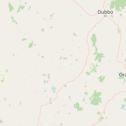
Map view of Conimbla National Park

Use this park location map to pinpoint Conimbla National Park in Australia, understand its exact geographic position, and read its mapped placement within the surrounding landscape more clearly.

Pigeon | © OpenStreetMap contributors

Location context for Conimbla National Park

New South Wales
Park atlas

Trace the Mountain Landscapes and Conservation Reserves Surrounding Conimbla National Park

Discover More National Parks Near Conimbla National Park, Central West NSW Protected Areas
After exploring Conimbla National Park, continue your geographic discovery by browsing other protected areas and national parks located across the Central West New South Wales region. Compare varied conservation landscapes, identify additional biodiversity refuges, and map the spread of native vegetation zones surrounding this prominent bush island.
National parkNew South Wales

Nangar National Park: Australian National Park Geography and Mapped Boundaries

Explore the protected landscape within New South Wales.

Nangar National Park is a key protected area situated in New South Wales, Australia, offering a valuable point for geographic discovery. This page details its status as a national park, providing insight into its mapped boundaries and its role within the regional landscape. Users can utilize this information to understand the park's specific geographic context and its contribution to the broader atlas of Australia's protected lands.

Area
94 km²
Established
1983
IUCN
II
Relief
Mountain
National parkNew South Wales

Weddin Mountains National Park: National Park Mapping and Geographic Context

Discover mapped protected landscape boundaries in New South Wales.

Weddin Mountains National Park represents a key protected area within New South Wales, Australia, offering a focused lens for geographic exploration. This detail page provides access to the park's specific mapped boundaries and its role as a national park. Understand the surrounding regional geography and the protected landscape's identity through a detailed atlas perspective, ideal for mapping conservation areas.

Area
83.61 km²
Established
1971
IUCN
II
Relief
Mountain
Watercolor depiction of a river, trees, and rolling hills in a landscape
National parkNew South Wales

Jindalee National Park: New South Wales National Park Protecting Cypress Pine Woodlands

Explore unique mapped terrain and regional conservation landscape.

Jindalee National Park represents a vital conservation effort in New South Wales, safeguarding remaining cypress pine woodlands and Critically Endangered grassy woodland ecosystems. Situated in the South West Slopes region, its undulating terrain and drainage lines form a distinctive natural landscape. The park's designation as a national park underscores its importance for preserving threatened species habitats and offers a focused point for atlas-driven discovery of its unique protected-area character and geographic context.

Area
10.76 km²
Established
2011
IUCN
II
Relief
Lowland
National parkNew South Wales

Abercrombie River National Park: A Protected Landscape in New South Wales

Explore its national park designation and mapped geography.

Delve into the details of Abercrombie River National Park, a designated national park situated in New South Wales. This entry focuses on its identity as a protected landscape, providing a geographically specific atlas perspective. Understand the extent of its mapped boundaries and its contribution to the regional geography, offering a clear view of its protected area status for discovery and reference.

Area
190 km²
Established
1995
IUCN
II
Relief
Mountain
National parkNew South Wales

Mares Forest National Park: New South Wales National Park Atlas and Protected Landscape

Explore mapped boundaries and forest terrain.

Mares Forest National Park, situated in New South Wales, offers a distinct protected landscape defined by its wet eucalyptus forest and kurrajong trees. As a national park, it provides valuable insight into the regional geography of the Southern Tablelands, showcasing its unique terrain and role as wildlife habitat. This park serves as an essential point for atlas-based exploration of Australia's conservation estate, highlighting its mapped boundaries and natural features.

Area
25.59 km²
Established
2010
IUCN
II
Relief
Upland
National parkNew South Wales

Turon National Park National Park: Protected Landscape and Geographic Atlas Details

Mapped boundaries and regional context within New South Wales.

Turon National Park is a protected national park in New South Wales, Australia, offering a distinct geographic identity for atlas exploration. This entry focuses on its mapped boundaries, natural terrain, and its role as a conservation landscape. Users can discover its specific features and regional context, enhancing their understanding of Australia's protected areas.

Established
2002
IUCN
II
Relief
Mixed relief
Climate
Temperate
National parkNew South Wales

Kanangra-Boyd National Park: A Protected Landscape within New South Wales' Geography

Mapped boundaries and regional park context.

Kanangra-Boyd National Park represents a significant protected area, offering valuable insights into the natural landscapes and geographic context of New South Wales. As a national park, it provides a clear example of mapped terrain and protected land distribution, crucial for anyone exploring the atlas of Australian conservation areas. Understanding this park contributes to a broader appreciation of its regional geography and specific landscape identity.

Area
686.6 km²
Established
1969
IUCN
Ib
Relief
Mountain
National parkNew South Wales

Tarlo River National Park: Rugged Protected Wilderness Landscape of New South Wales

Explore its unique terrain, mapped boundaries, and cultural heritage.

Tarlo River National Park stands as a testament to rugged protected wilderness within New South Wales, Australia. Its distinctive terrain, marked by steep valleys and rocky ridges, presents a rare topographical feature not replicated elsewhere in the region. This national park is also a vital site for Aboriginal cultural heritage, offering a unique lens through which to understand Australia's protected landscapes. The park's mapped geography provides essential context for appreciating its conservation significance and the preservation of its natural and cultural values.

Area
80.74 km²
Established
1982
IUCN
II
Relief
Upland

Common questions about visiting, size, designation, and location context for Conimbla National Park

Conimbla National Park FAQs for park facts, access, geography, and protected area context
Find quick answers about Conimbla National Park, including protected-area facts, park geography, trail and visitor context, and how the park fits into its surrounding country and regional landscape.
MoriAtlas Explorer

Continue Your Protected Areas Search Across the Global Atlas

Deepen your exploration by continuing the structured search for national parks and protected areas worldwide. Utilize the comprehensive filtering capabilities to compare different conservation landscapes and refine your understanding of global park geography. Discover more about the distribution and characteristics of protected natural areas.

Global natural geography