Mori Atlas logo
Nature reserveConradswiese

A classic mountain forest clearing located along the watershed of the Zwickauer Mulde and Schwarzwasser.

Conradswiese Nature Reserve: Mapping the Forest and Meadow Landscapes of the Saxon Erzgebirge

(Naturschutzgebiet Conradswiese)

Conradswiese is a significant nature reserve situated at 645 meters above sea level on the slopes of the Morgenleithe in the western Erzgebirge of Saxony. The area showcases a transition between open mountain meadows and dense Bergmischwald, preserving a unique forest meadow complex that reflects the historical and ecological character of the Saxon highlands. As a center for forest education and silvicultural research, the site serves as a vital protected landscape for the study of regional habitat management and mountain woodland ecosystems.

Erzgebirgeforest meadowmixed mountain forestnature reserveSaxon uplandsWaldwiese

Conradswiese

Nature reserve

Park overview

Structured park overview, official facts, and landscape profile for Conradswiese

Conradswiese park facts, protected area profile, and essential visitor context

Review the core facts for Conradswiese, including designation, size, terrain, visitor scale, habitats, and operating context in one park-focused overview.

About Conradswiese

Conradswiese lies in the western Ore Mountains of Saxony, in the upper reaches of a landscape historically defined by mining, smelting, and forestry. The protected area encompasses a Waldwiese, a forest clearing or mountain meadow, surrounded by Bergmischwald, the mixed deciduous and coniferous forest typical of the higher elevations of the Erzgebirge. At roughly 645 meters above sea level and situated on the western flank of the Morgenleithe, the reserve reflects the transition between montane forest and open clearing habitats that once characterized this part of the Saxon uplands.

Beyond its ecological role, the site carries a layered human history. The buildings below the Morgenleithe originated as a small outworking (Vorwerk) belonging to the administrative town of Schwarzenberg in the Erzgebirge, and were later taken over by the forestry office at Bockau. The earliest documented name, Cunnertswiesen, dates to 1646. Through the nineteenth century the site functioned as a forester's house, a simple inn, and a popular Waldgasthaus serving day visitors, especially from Lauter. After the Second World War the inn closed and the buildings served as a forestry training station until 1957, then as a company holiday home until 1990, before being converted into the Conradswiese Forest School (Waldschulheim Conradswiese) under Sachsenforst.

The nature reserve itself is small in inventory terms but ecologically meaningful, classified as an IUCN Category IV area focused on habitat and species management. Its location above the watershed between the Zwickauer Mulde to the west and the Schwarzwasser to the east gives it a subtle hydrological significance within the broader Erzgebirge river system. Trails such as the Alter Jägerhäuser Weg radiate outward from the clearing, and the open Tränktrögel (a historic wildlife watering site) sits nearby in the forest, reinforcing the area's character as a place where working forestry heritage, ecological protection, and outdoor education intersect.

Quick facts and research context for Conradswiese

Conradswiese is a Saxon nature reserve located in the western Erzgebirge within the municipality of Lauter-Bernsbach, at approximately 645 meters elevation on the western flanks of the Morgenleithe. The reserve covers about 39 square kilometers of terrain (as listed in the official designation) and combines a central Waldwiese (forest meadow) with surrounding Bergmischwald, the mixed mountain forest typical of the higher Ore Mountains. It carries the WDPA protected-area identifier 162683, the German designation code C 18, and is classified under IUCN Category IV as a Habitat and Species Management Area. The site is administratively connected to the state forest service Sachsenforst, whose Forest District Eibenstock maintains a forest school (Waldschulheim) on the historic grounds of an early forestry outworking.

Protection and recognition

Examine official records, international recognition, and conservation designations for Conradswiese.

Conradswiese Protection Status and Documented Protected Area Record

Examine the verified protection status and administrative records linked to Conradswiese within global databases. Official designation details and international recognition metrics offer clear context for conservation research.

Protection details

WDPA ID
162683
Park context

Deeper park guide and search-rich context for Conradswiese

Conradswiese history, landscape, wildlife, and travel context

Explore Conradswiese through its history, landscape character, ecosystems, wildlife, conservation priorities, cultural context, and seasonal travel timing in a structured park guide built for atlas discovery and search intent.

Why Conradswiese stands out

Conradswiese is best known as a small but characteristic example of an Erzgebirge forest-meadow complex, where an open mountain clearing sits embedded within a larger tract of Bergmischwald. The reserve is particularly associated with the conservation and study of mixed mountain forest habitats at upper-mid elevations of the Ore Mountains, including the silver fir (Weißtanne, Abies alba), which has been the subject of genetic conservation research conducted from the Tharandt forest botany institute of TU Dresden. The site is also recognized for its educational role through Waldschulheim Conradswiese, a long-standing forest school operated by Sachsenforst. Programs at the Waldschulheim include forest youth games (Waldjugendspiele) and thematic activities on topics such as the return of the wolf to German landscapes, linking conservation science with hands-on public environmental education.
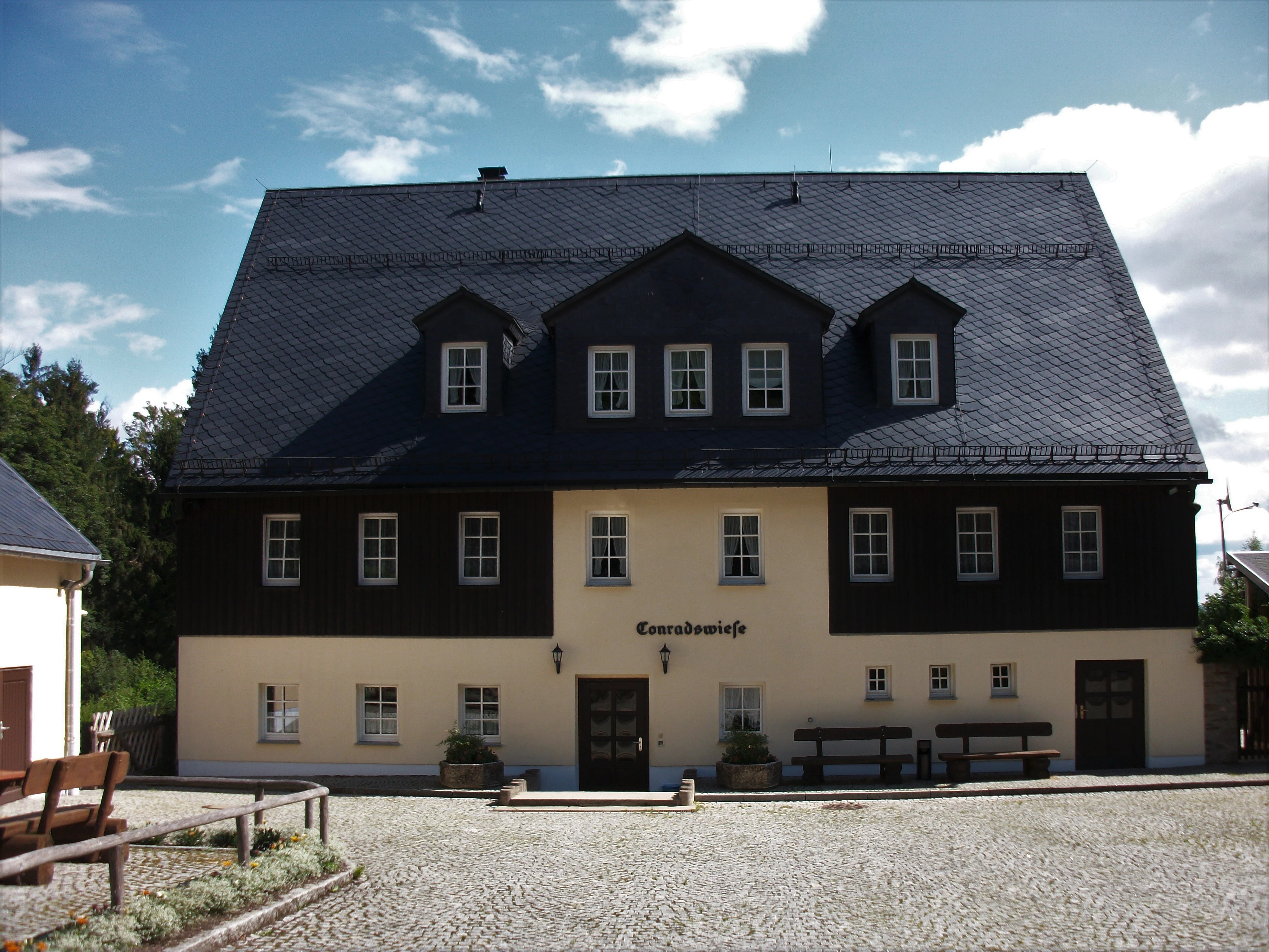
A two-story building with dark wooden siding on the upper floor, cream-colored lower walls, and a large slate-tiled roof, set in a courtyard with a gravel surface.
The Waldschulheim forest school building situated within the Conradswiese nature reserve.

Conradswiese history and protected-area timeline

The history of Conradswiese reaches back to the early modern period. The name Cunnertswiesen appears in records as early as 1646, indicating long-standing use of the clearing. The original buildings on the site derived from a small outworking of the Amtsstadt Schwarzenberg in the Erzgebirge, and were later taken on by the Oberförsterei, or higher forestry office, of Bockau. Ecclesiastically, Conradswiese was linked, together with Fällbach, to the parish of Bockau, while administratively and in terms of land registry it belonged to Lauter within the Kreisamt Schwarzenberg.

In the nineteenth century the forester's, warden and forest house was used as a simple tavern as early as 1839, growing into a Waldgasthaus that drew many day visitors, particularly from the direction of Lauter. The inn closed at the end of the Second World War, after which the building served as a forestry training facility until 1957. From the late 1950s it functioned as a Betriebsferienheim, a company holiday home, until 1990. Following German reunification the complex was converted into the Waldschulheim Conradswiese, a forest school run by Sachsenforst (the state forest enterprise of Saxony) and its Forstbezirk Eibenstock. The school hosts forest youth games and educational workshops, and has more recently been used as a base for academic work by the TU Dresden Institute of Forest Botany and Forest Zoology, including research on silver fir (Abies alba) genealogy and forest pedagogy projects on wolves in Germany.

Conradswiese landscape and geographic character

The reserve sits on the upper western slopes of the Erzgebirge at roughly 645 meters above sea level, on the flank of the Morgenleithe. The defining landform of the site is a forest clearing, the Waldwiese, set within a larger ring of mixed mountain forest. The forest itself is a Bergmischwald, the classic Erzgebirge mix of spruce, fir, and beech characteristic of mid- to upper-elevation sites in the Saxon Ore Mountains.

A notable geographic feature of the area is its position along the watershed between two river systems: the Zwickauer Mulde to the west and the Schwarzwasser to the east. This subtle but real hydrological divide runs through the forest above the clearing. Other landscape elements include the historic Tränktrögel, a small woodland watering feature used in earlier centuries for game, and the Alter Jägerhäuser Weg, an old forest track running roughly 3.5 kilometers toward Jägerhaus near Schwarzenberg.

Conradswiese ecosystems, habitats, and plant life

The ecological interest of Conradswiese lies in its juxtaposition of two complementary habitats at upper-mid elevation of the Saxon Ore Mountains: an open mountain meadow and the surrounding Bergmischwald. The Waldwiese provides sun-exposed grassland habitat and ecological edge effects, while the encircling mixed forest offers cooler, shaded interior conditions. Together they form a mosaic that supports the range of plant and animal communities typical of transitional Erzgebirge landscapes.

The site's mix of spruce, silver fir, and beech is consistent with traditional Erzgebirge silviculture and is one reason the area has been used for conservation-oriented silvicultural study. Research on the genetic background of silver fir (Abies alba) progeny from the nearby Erhaltungssamenplantage, or conservation seed plantation, of Conradswiese and Bockau underlines the value of the area for forest genetic resources. The reserve is also a working landscape for forest education, with the Waldschulheim providing a continuous input of observational and pedagogical activity into the surrounding woodland.

Conradswiese wildlife and species highlights

The source material describes Conradswiese primarily as a forest-meadow reserve and does not provide detailed species inventories. Its wildlife character can be inferred from its landscape composition: a forest clearing within a Bergmischwald supports the typical bird, insect, and mammal assemblages of Erzgebirge mixed forests at around 600 to 700 meters elevation, including small mammals, forest birds, and the wider community associated with montane spruce, fir, and beech stands.

The site's modern role in environmental education has placed it in the broader discourse about larger carnivores in Germany: a 2014 academic work from TU Dresden developed a forest-pedagogical concept on the theme of the wolf in Germany specifically for the Waldschulheim Conradswiese, reflecting the rising relevance of returning large predators in Saxon forest landscapes.

Conradswiese conservation status and protection priorities

Conradswiese is officially designated as a Naturschutzgebiet, a nature reserve, under German Saxon conservation law, and is registered internationally with WDPA ID 162683. Its IUCN classification is Category IV, Habitat/Species Management Area, indicating that the primary conservation objective is the active management of particular habitats and species rather than the maintenance of a strict, undisturbed wilderness.

The reserve forms part of the network of protected areas in the Erzgebirgskreis, alongside other Saxon Naturschutzgebiete such as Bockautal, Fichtelberg, Großer Kranichsee, and the Schwarzwassertal. Through the Waldschulheim, it also serves a conservation-education function, communicating forest ecology, forest heritage, and species-management themes to school groups, youth programs, and the wider visiting public under the auspices of Sachsenforst.

Conradswiese cultural meaning and human context

Conradswiese is embedded in the cultural landscape of the upper Erzgebirge, a region historically defined by mining, forestry, and small mountain settlements. The clearing and its buildings originated as a forestry outworking tied to Schwarzenberg and Bockau, and the site evolved through the centuries as a forester's house, a public inn, a training station, a holiday home, and finally a forest school, each layer reflecting a different era of Saxon rural and forestry history.

The Waldgasthaus tradition, in particular, made the clearing a familiar destination for day visitors from Lauter during the nineteenth and early twentieth centuries, embedding it into regional leisure and hiking culture. Today, the Waldschulheim carries that legacy forward in an educational key, hosting Waldjugendspiele and academic collaborations with TU Dresden that link Conradswiese to wider Saxon identity, forestry heritage, and contemporary debates about forests and wildlife in Germany.

Top sights and standout views in Conradswiese

A compact Erzgebirge forest-meadow reserve combining a classic Waldwiese with surrounding Bergmischwald, set at roughly 645 meters on the lower slopes of the Morgenleithe. Its position along the watershed between the Zwickauer Mulde and the Schwarzwasser adds quiet geographic interest, while its historic Tränktrögel and old forester's paths underscore its identity as a long-used working forest landscape. The site is also notable as the home of Waldschulheim Conradswiese, where forest education, silvicultural research, and habitat management come together under the auspices of Sachsenforst.

Best time to visit Conradswiese

Conradswiese lies at roughly 645 meters elevation in the western Erzgebirge, where winters are typically snowy and summers are mild to warm, with vegetation conditions similar to other mid-elevation Saxon upland sites. The forest-meadow character of the reserve is most striking in late spring and summer, when the open Waldwiese is in active growth and the surrounding mixed forest is fully leafed. Autumn brings coning and the seasonal color shift typical of mixed spruce, fir, and beech stands, while winter offers a quieter, snow-covered atmosphere that aligns with the site's traditions as a Waldgasthaus destination and forest-school setting. As an actively managed educational and conservation site, visitors generally encounter the reserve on guided walks, school programs, and self-directed hikes along forest tracks such as the Alter Jägerhäuser Weg.

Monthly climate preview

Long-term representative point measurements tracking annual temperature and precipitation rhythm

Conradswiese Climate Normals and Monthly Weather Records in Sachsen

Representative coordinate records show measured monthly temperature variations alongside steady precipitation patterns across the elevation profile. Complete twelve-month climate normals provide detailed numerical context for long-term meteorological research in Sachsen.
Annual mean7 °C
-3 °C17 °C
Jan-3°
Feb-2°
Mar
Apr
May12°
Jun15°
Jul17°
Aug17°
Sep13°
Oct
Nov
Dec-1°
Warmest month
July

17.5 °C

Coolest month
January

-2.5 °C

Wettest month
July

2.8 mm/day

Driest month
April

1.4 mm/day

Park location guide

Geography guide, regional context, and park location map for Conradswiese

Conradswiese park geography, regions, and map view in Germany

Understand where Conradswiese sits in Germany through a broader geographic reading of the surrounding landscape, nearby location context, and its mapped position within the national park landscape.

How Conradswiese fits into Germany

Germany is a federal republic in Western and Central Europe with a population of over 83 million across sixteen constituent states. It is Europe's largest economy by nominal GDP and a major global exporter and importer. The capital is Berlin, and the country borders Denmark, Poland, Czech Republic, Austria, Switzerland, France, Luxembourg, Belgium, and the Netherlands.

Wider geography shaping Conradswiese in Germany

Germany is located in Western and Central Europe, spanning 357,022 km². It borders Denmark to the north, Poland and the Czech Republic to the east, Austria and Switzerland to the south, and France, Luxembourg, Belgium, and the Netherlands to the west. The country has coastlines on the Baltic Sea and North Sea to the north, with the Alps located in the southern region.

Map view of Conradswiese

Use this park location map to pinpoint Conradswiese in Germany, understand its exact geographic position, and read its mapped placement within the surrounding landscape more clearly.

Pigeon | © OpenStreetMap contributors

Location context for Conradswiese

Sachsen

Explore protected habitats, mountain clearings, and mixed forest scenery across Conradswiese.

Conradswiese Photos and Landscape Views: Visualizing Ore Mountain Nature Reserves

Photographic documentation reveals the distinct transition between open mountain meadows and dense mixed forest within this Saxon reserve. Visual reference material captures the terrain, canopy structure, and protected landscape character defining the upper Ore Mountains.

A two-story building with dark wooden siding on the upper floor, cream-colored lower walls, and a large slate-tiled roof, set in a courtyard with a gravel surface.

Park atlas

Compare surrounding mountain forests and connected nature reserves across Saxony

Explore Protected Areas and Parks Near Conradswiese in the Erzgebirge

Visitors exploring Conradswiese can browse other protected areas and mountain reserves located across the surrounding region. Comparing these adjacent forest landscapes provides a broader geographic view of the upper Ore Mountains and local conservation patterns.
Nature reserveSachsen
About 8.2 km away#1 closest

South

Friedrichsheider Hochmoor Nature Reserve: Geography and Protected Bog Landscape in Sachsen

High-elevation peatland and bog pine forest mapping

Situated at 800 meters above sea level near Sosa, Friedrichsheider Hochmoor serves as a cornerstone of peatland conservation in the Erzgebirge. This reserve is defined by its thick peat body and dense Spirken moor forest, offering a rare look at near-intact mire ecosystems that support diverse Sphagnum mosses and subarctic plant communities within a protected regional framework.

Area
0.19 km²
Established
1967
IUCN
IV
Nature reserveSaxony
About 9.2 km away#2 closest

West

Heide und Moorwald am Filzteich: Nature Reserve and Bog Landscape in Saxony

Protected moorland forest and heathland geographic context

Heide und Moorwald am Filzteich provides a unique look at habitat management in the Erzgebirge region. This nature reserve, adjacent to the Filzteich reservoir, encompasses a protected mosaic of open heath, remnant bog systems, and historical peatland terrain. Its geographic boundaries offer insights into the transitional landscapes of the Saxon uplands and local water table influences on wetland biodiversity.

Area
3.14 km²
Established
2010
IUCN
IV
Nature reserveSachsen
About 12 km away#3 closest

North

Hartensteiner Wald Nature Reserve: Saxon Protected Landscapes and Regional Geography

Woodland habitat and river valley terrain in Zwickau

Hartensteiner Wald functions as a key Natura 2000 protected area within the Free State of Sachsen. This reserve offers a layered landscape of native beech woodlands, steep valley slopes, and striking rocky outcrops along the Zwickauer Mulde. Use this atlas perspective to map the reserve's historic features, such as the Prinzenhöhle and Knoblauchfelsen, while understanding its conservation role in the broader Erzgebirge transition zone.

Area
0.89 km²
Established
1961
IUCN
IV
Relief
Upland
A horizontal watercolor illustration of a gentle landscape with scattered trees, soft green foliage, and faint mountain outlines in the background.
Nature reserveSaxony
About 14 km away#4 closest

Southwest

Am Riedert Nature Reserve: Protected Mountain Forest Geography in Saxony, Germany

Analyzing the ecological boundaries and Hercynian mountain mixed forest terrain

Am Riedert is a compact but ecologically important nature reserve situated on the rugged slopes of the western Erzgebirge. This site protects a significant example of mountain mixed forest, characterized by its mature silver fir populations and active natural regeneration. By examining its location south of the Zwickauer Mulde river, visitors can trace the intersection of Saxon history and conservation within this unique protected landscape.

Area
0.185 km²
Established
1961
IUCN
IV
Relief
Mountain
Watercolor painting of a flat marshy landscape with a small winding stream in the foreground, green trees in the midground, and soft purple mountain silhouettes in the distance.
Nature reserveSaxony
About 16 km away#5 closest

Southwest

Großer Kranichsee Nature Reserve: Protected Raised Bog Geography and Ore Mountain Landscapes

Watershed moorland, mountain pine forests, and Saxony high plateau geography.

Großer Kranichsee serves as a primary example of an intact raised bog system in the Ore Mountains. The reserve features rare peat-forming vegetation and highland bog forests, occupying a high-altitude plateau that bridges the border between Saxony and the Czech Republic. Its geographic significance stems from its role as a triple watershed, defining the drainage patterns for three distinct regional river systems within the protected Erzgebirgskamm zone.

Area
6.11 km²
Established
1912
Natural monumentKarlovarský kraj
About 16 km away#6 closest

South

Vlčí jámy Natural Monument: Protected Geological and Industrial Heritage in Bohemia

Ore Mountains mining collapse and relict microclimate landscape

Vlčí jámy protects a rare intersection of medieval mining history and environmental significance in the Karlovarský kraj. The site is defined by two deep collapse features, Ledová jáma and Vlčí jáma, which function as persistent cold traps. These geological anomalies support critically endangered mosses and bat colonies, illustrating how abandoned industrial landscapes in the Ore Mountains evolve into essential, small-scale protected habitats.

Area
0.014 km²
Established
1975
IUCN
III
Relief
Mountain
A horizontal watercolor painting showing rolling green hills and distant mountain ridgelines behind a foreground of grassy meadows and trees.
Nature reserveSaxony
About 17 km away#7 closest

Southwest

Dreibächel Nature Reserve: Mapping the Old-Growth Spruce Stands of the Western Ore Mountains

A historic protected landscape and mountain watershed in Saxony, Germany

Dreibächel serves as a living archive of traditional forest management, holding the distinction of containing the oldest spruce trees in Saxony. Located on the slopes of the Schneehübel, the reserve is characterized by a dense, multi-layered mountain forest canopy and the confluence of three vital streams. The area remains a essential site for observing historical plenterwald ecology and the natural hydrology of the Westerzgebirge region.

Area
0.147 km²
Established
1961
IUCN
IV
A horizontal watercolor illustration depicting a soft, green, mountain landscape with hills, conifers, and a waterlogged meadow.
Natural monumentKarlovy Vary Region
About 20 km away#8 closest

South

Rudenská luční prameniště Natural Monument: Protected Mountain Wetland Atlas

Karlovy Vary Region Ore Mountains landscape mapping

Rudenská luční prameniště is a protected mountain wetland in the Ore Mountains, defined by a distinct mosaic of spring fens, peat deposits, and mountain meadows. Its geographic layout, spanning twenty three hectares across sloping terrain, creates a vital drainage system for the local landscape. By examining this protected site, you can better understand the unique hydrological and botanical features that distinguish these rare mountain mire complexes from the surrounding highland forests.

Area
0.232 km²
Established
2020
IUCN
IV
Relief
Mountain

Common questions about visiting, size, designation, and location context for Conradswiese

Conradswiese FAQs for park facts, access, geography, and protected area context

Find quick answers about Conradswiese, including protected-area facts, park geography, trail and visitor context, and how the park fits into its surrounding country and regional landscape.
MoriAtlas Explorer

Continue Your Protected Areas Search Across the Global Atlas

Deepen your exploration by continuing the structured search for national parks and protected areas worldwide. Utilize the comprehensive filtering capabilities to compare different conservation landscapes and refine your understanding of global park geography. Discover more about the distribution and characteristics of protected natural areas.

Global natural geography