
Mori Atlas logo
Marine protected areaCook Island Aquatic Reserve

Explore the reef ecosystems and zoned marine boundaries defining this coastal reserve.

Cook Island Aquatic Reserve: Mapping the Protected Marine Landscapes of New South Wales

Cook Island Aquatic Reserve protects the vital reef communities and marine habitats surrounding a rocky island off the far north coast of New South Wales. This marine protected area serves as an essential nexus for tropical and temperate species, featuring a zoned management approach that separates a no-fishing core from surrounding waters. The reserve provides critical structural complexity for diverse marine life, standing as a significant coastal landscape within the broader Australian maritime geography.

aquatic reservemarine protected areareef ecosystemcoastal reserveisland reserveshark habitat
A flat vector-style illustration of a coastal scene featuring a small island in the distance, gentle ocean waves, a sandy shoreline with rocks, and grasses in the foreground, all bathed in soft sunset lighting.

Cook Island Aquatic Reserve

Marine protected area

Park overview

Structured park overview, official facts, and landscape profile for Cook Island Aquatic Reserve

Cook Island Aquatic Reserve park facts, protected area profile, and essential visitor context

Review the core facts for Cook Island Aquatic Reserve, including designation, size, terrain, visitor scale, habitats, and operating context in one park-focused overview.

About Cook Island Aquatic Reserve

Cook Island Aquatic Reserve sits in the South Pacific Ocean along the Tweed Coast of New South Wales, anchoring a small but ecologically meaningful marine protected area around a rocky island roughly 600 metres from the mainland at Fingal Head. Established in the late 1990s, the reserve was designed to protect the reef communities and surrounding waters of an island that, despite its tiny footprint, supports a remarkable concentration of marine life.

The reserve's design reflects careful marine planning. Its area is defined in relation to the mean high water mark of the island and extends outwards across the surrounding ocean, encompassing both shallow reef zones where biodiversity is concentrated and the wider waters where fishing activity continues to occur under controlled conditions. The reserve is administered by the New South Wales Department of Primary Industries, which oversees aquatic reserves across the state as part of a broader network of marine conservation areas.

For visitors and the local community alike, the reserve represents a focal point for marine appreciation on the Tweed Coast. Its accessibility from the mainland, its clear waters, and the abundance of reef life all contribute to its appeal. Yet the reserve's deeper importance lies in what it preserves beneath the surface: a functioning reef ecosystem at the transition between tropical and temperate marine provinces, and habitat that supports both resident reef species and larger migratory animals moving along the east Australian coast.

Quick facts and research context for Cook Island Aquatic Reserve

Cook Island Aquatic Reserve is a New South Wales marine protected area situated about 600 metres offshore from Fingal Head, near the Queensland border on Australia's east coast. Declared on 23 October 1998 under the state's Fisheries Management Act 1994, the reserve covers the waters surrounding Cook Island up to the mean high water mark and extends outwards in a roughly circular pattern.

The reserve is managed by the New South Wales Department of Primary Industries and operates under a zoned system that pairs a fully protected no-fishing area with an outer zone allowing line fishing. It is small in scale but ecologically significant, recognised for its reef biodiversity and its role as habitat for sharks and other marine fauna frequenting the Tweed Coast.

Protection and recognition

Examine the documented marine protection status and official governance details.

Cook Island Aquatic Reserve Protection Status and Marine Conservation Framework

Marine protection status records for Cook Island Aquatic Reserve outline the documented conservation scope and administrative framework. Verified governance data provides clear insight into the protected area designation and management parameters.

Protection details

Protection scope
Marine
Transboundary protection
No
Park context

Deeper park guide and search-rich context for Cook Island Aquatic Reserve

Cook Island Aquatic Reserve history, landscape, wildlife, and travel context

Explore Cook Island Aquatic Reserve through its history, landscape character, ecosystems, wildlife, conservation priorities, cultural context, and seasonal travel timing in a structured park guide built for atlas discovery and search intent.

Why Cook Island Aquatic Reserve stands out

Cook Island Aquatic Reserve is best known for the rich reef communities encircling the small rocky island just off Fingal Head, and for its recognised importance as shark habitat along the New South Wales far north coast. The reserve sits at a meeting point between tropical and temperate marine influences, which contributes to a particularly varied fish fauna for such a small area. The reserve is also notable for its clear zoned management approach. A no-fishing core bounded by marker buoys protects the most sensitive reef habitat, while a surrounding zone permits line fishing, illustrating a balance between ecological protection and continuing recreational use. Its proximity to the mainland, combined with the diversity of reef life it supports, gives the reserve a significance that punches well above its modest size.
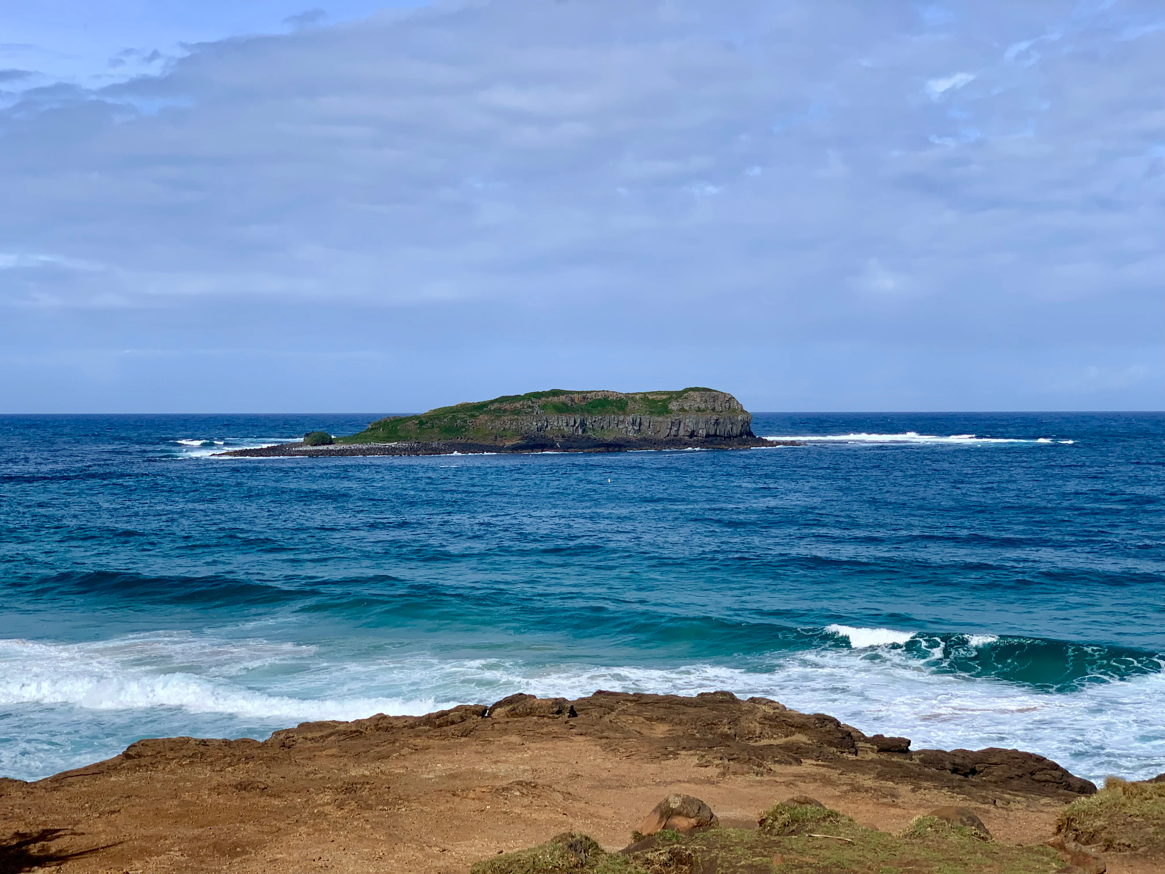
A distant view of a small, green island surrounded by the blue ocean, seen from a rocky coastal vantage point.
Cook Island viewed from the coast of Fingal Head.

Cook Island Aquatic Reserve history and protected-area timeline

Cook Island Aquatic Reserve was formally declared on 23 October 1998 under New South Wales' Fisheries Management Act 1994, becoming part of the state's growing system of aquatic reserves designed to protect representative marine habitats. The reserve was established around an existing rocky island environment that had long been recognised locally for the productivity and diversity of its surrounding waters.

The declaration followed a period during which New South Wales increasingly recognised the value of formal marine protection along its coast. By placing the waters around Cook Island under reserve status, the state created a legal framework for managing fishing pressure, protecting reef habitat, and safeguarding the diverse fish and invertebrate communities of the area. The reserve's zoned structure, combining a fully protected core with a line-fishing outer zone, was developed to provide meaningful protection while still accommodating recreational use.

In the years since its establishment, the reserve has continued to be regarded as an important local marine asset. Municipal authorities and environmental commentators have highlighted its ecological role, including its recognised value as shark habitat. The reserve now forms one element of the broader New South Wales network of aquatic reserves administered by the Department of Primary Industries.

Cook Island Aquatic Reserve landscape and geographic character

Cook Island Aquatic Reserve surrounds a small rocky island that rises from the South Pacific Ocean just offshore from Fingal Head on the far north coast of New South Wales. The island itself is compact and rugged, sitting at the outer edge of a coastal landscape shaped by volcanic headlands, sandy beaches, and the broad mouth of the Tweed River system nearby.

The marine landscape within the reserve is dominated by reef formations and varied seafloor topography encircling the island. Shallow reef platforms and rocky reef structures are central to the reserve's character, supporting dense communities of marine life. Around these reef zones, the seafloor grades into deeper sandy and rubble areas that extend across the rest of the reserve's waters.

Above the waterline, the island acts as a small but prominent visual landmark along the coast, visible from Fingal Head and from elevated lookouts in the surrounding area. Below the surface, the reserve's reef-dominated seascape provides the structural backbone for its ecological richness, offering shelter, feeding grounds, and breeding habitat for a wide variety of marine species in a setting shaped by the swell and clear waters typical of the eastern Australian coastline.

Cook Island Aquatic Reserve ecosystems, habitats, and plant life

Cook Island Aquatic Reserve protects a compact but ecologically rich marine environment centred on the reef systems surrounding Cook Island. The reserve's habitats include shallow rocky reef platforms, deeper reef structures, and surrounding seafloor environments that together support a high diversity of marine life for such a small area.

The reserve lies in a transition zone where tropical and temperate marine influences meet, and this is reflected in the variety of species found within its waters. Reef-associated habitats dominate the protected area, providing shelter for a wide range of fish, invertebrates, and other marine animals. The combination of rocky substrate, clear oceanic water, and varied seafloor topography creates the ecological complexity that underpins the reserve's biodiversity.

The reserve's no-fishing core plays a particularly important ecological role, allowing reef communities to develop with minimal direct human pressure. Within this zone, reef structures support dense populations of fish and invertebrates, which in turn attract larger predatory and migratory species. The result is a small marine protected area whose ecological character is shaped as much by the productivity and connectivity of its reef environments as by its size on a map.

Cook Island Aquatic Reserve wildlife and species highlights

The waters of Cook Island Aquatic Reserve host an impressive variety of marine life for such a small protected area. The reserve is particularly notable for its fish diversity, with reef-dwelling species including anemonefish, bullseyes, groupers, leatherjackets, parrotfish, pufferfish, surgeonfish, sweetlips, and trevally recorded within its boundaries.

Sharks are among the reserve's most significant wildlife features. Blind sharks, leopard sharks, wobbegongs, and various migratory shark species have been recorded frequenting the area, leading Tweed Shire Council's Coast and Waterways Officer Tom Alletson to note in 2009 that the reserve constitutes important shark habitat. This recognition underlines the reserve's ecological role beyond its reef fish communities, highlighting its value as habitat for species that range widely along the east Australian coast.

In addition to fish and sharks, the reserve supports a broad range of other marine animals. Brittle stars, flatworms, shrimps, nudibranchs, crustaceans, molluscs, and stingrays are all present in the waters around Cook Island. Green turtles and jellyfish have also been recorded, contributing to a faunal profile that reflects both the reef productivity of the site and its position along a major oceanic migration corridor.

Cook Island Aquatic Reserve conservation status and protection priorities

Cook Island Aquatic Reserve was established specifically to provide formal protection for the marine environment surrounding Cook Island, recognising both the productivity of its reef communities and the ecological value of its waters. Declared under New South Wales' Fisheries Management Act 1994, the reserve contributes to the state's broader network of aquatic reserves aimed at conserving representative marine habitats along the coast.

The reserve's zoned conservation design is central to its ecological function. A no-fishing core, anchored by marker buoys and managed as an IUCN Category II area, provides the highest level of protection within the reserve, allowing reef communities and associated fauna to thrive with minimal direct human impact. The surrounding waters, classified as an IUCN Category IV habitat and species management area, permit line fishing only, providing a buffer zone while still contributing to broader conservation outcomes.

Beyond its formal conservation designations, the reserve is recognised for its role in maintaining habitat for sharks and other species of conservation interest along the Tweed Coast. Its accessibility, reef complexity, and position at the interface between tropical and temperate marine provinces give it an importance that extends well beyond its modest size, making it a meaningful contributor to marine biodiversity conservation in northern New South Wales.

Cook Island Aquatic Reserve cultural meaning and human context

Cook Island Aquatic Reserve sits within a regional landscape long valued for its coastal scenery, recreational waters, and abundance of marine life. The Tweed Coast area, where the reserve is located, has a strong identity tied to the ocean, with Fingal Head serving as a well-known lookout and surf-oriented destination adjacent to the reserve.

Local government and community stakeholders have taken an active interest in the reserve's ecological role, particularly regarding its value as habitat for sharks and other marine species. Recognition of the reserve by Tweed Shire Council underscores its place within the broader coastal identity of the region, where marine conservation sits alongside fishing heritage, tourism, and outdoor recreation.

While the reserve itself does not carry a major built-heritage or indigenous-cultural profile in the available sources, its proximity to culturally and recreationally significant coastal sites places it within a wider cultural context shaped by centuries of human interaction with the New South Wales far north coast.

Top sights and standout views in Cook Island Aquatic Reserve

Cook Island Aquatic Reserve's standout quality is the concentration of marine biodiversity around such a small rocky island, supported by reef habitats at the boundary between tropical and temperate marine influences.

The reserve's zoned management approach, combining a fully protected no-fishing core with a controlled fishing outer zone, gives it both ecological integrity and practical relevance for the local community. Its recognition as important shark habitat further elevates its standing as a marine protected area of regional significance along the New South Wales coast.

Best time to visit Cook Island Aquatic Reserve

The waters around Cook Island Aquatic Reserve offer their clearest conditions and warmest temperatures during the southern hemisphere summer and early autumn months, when visibility for diving and snorkeling is typically at its best along the Tweed Coast. During this period, calm seas and warmer water enhance the experience of the reserve's reef communities, which are the main attraction for most visitors.

Cooler months bring rougher swells and less predictable conditions, but can still offer rewarding viewing on calmer days, particularly for divers and fishers familiar with local conditions. Wildlife viewing, including reef fish, sharks, and visiting turtles, can occur throughout much of the year, though specific seasonal concentrations of migratory species may vary.

Visitors should generally recognise that conditions on the far north coast of New South Wales can shift rapidly, and the reserve's exposure to open ocean means that weather and swell heavily influence the experience of any visit regardless of season.

Monthly climate preview

Long-term representative monthly temperature and precipitation rhythm

Cook Island Aquatic Reserve Climate Normals and Annual Temperature Patterns

Cook Island Aquatic Reserve displays measured long-term temperature swings and precipitation averages across representative coordinates in New South Wales. Examining the complete monthly climate dataset provides deeper insight into historical meteorological patterns for the protected area.
Annual mean22 °C
18 °C25 °C
Jan25°
Feb25°
Mar25°
Apr23°
May21°
Jun19°
Jul18°
Aug19°
Sep20°
Oct21°
Nov23°
Dec24°
Warmest month
February

25.2 °C

Coolest month
July

18.5 °C

Wettest month
February

5.7 mm/day

Driest month
September

1.2 mm/day

Park location guide

Geography guide, regional context, and park location map for Cook Island Aquatic Reserve

Cook Island Aquatic Reserve park geography, regions, and map view in Australia

Understand where Cook Island Aquatic Reserve sits in Australia through a broader geographic reading of the surrounding landscape, nearby location context, and its mapped position within the national park landscape.

How Cook Island Aquatic Reserve fits into Australia

Australia is a constitutional monarchy and federal parliamentary democracy comprising six states and ten territories. With a population of nearly 28 million, it is one of the world's most urbanised countries, with most people concentrated on the eastern seaboard. The country has a high Human Development Index and is known for its cultural diversity, ancient Aboriginal heritage, and unique wildlife.

Wider geography shaping Cook Island Aquatic Reserve in Australia

Australia occupies the entire Australian continent, the island of Tasmania, and numerous smaller islands. It is the world's flattest and driest inhabited continent, featuring vast deserts in the interior (the Outback), tropical rainforests along the eastern coast, and a coastline bordering the Indian and Pacific Oceans.

Map view of Cook Island Aquatic Reserve

Use this park location map to pinpoint Cook Island Aquatic Reserve in Australia, understand its exact geographic position, and read its mapped placement within the surrounding landscape more clearly.

Pigeon | © OpenStreetMap contributors

Location context for Cook Island Aquatic Reserve

New South Wales

Visualizing marine habitats, rocky island terrain, and coastal reef environments

Cook Island Aquatic Reserve Photos and Mapped Landscape Scenery

Visual documentation captures the rugged terrain, shallow reef platforms, and distinct marine habitats defining Cook Island Aquatic Reserve. Examining these coastal photographs reveals the unique topography and protected environments supporting diverse reef communities.

A distant view of a small, green island surrounded by the blue ocean, seen from a rocky coastal vantage point.

Park atlas

Compare nearby marine reserves, coastal ecosystems, and protected waters across the region

Other Parks Near Cook Island Aquatic Reserve and Surrounding Protected Coastal Areas

Browsing other protected areas near Cook Island Aquatic Reserve reveals broader marine conservation patterns along the coast. Comparing adjacent coastal reserves and reef ecosystems provides a wider geographic perspective on regional biodiversity.
A soft watercolor painting of a landscape featuring rolling green hills, a faint mountain range in the distance, and sparse vegetation in the foreground.
Nature reserveNew South Wales
About 0.2 km away#1 closest

North

Cook Island Nature Reserve: Coastal Protected Landscapes and Island Geography in New South Wales

Strictly protected island terrain and offshore seabird refuge.

Cook Island Nature Reserve represents a specialized five-hectare island protected area off the northern New South Wales coastline. This offshore site functions as a vital nature reserve, characterized by its preserved scrub vegetation and role as a high-value habitat for breeding seabirds. Its geographic isolation and strict conservation focus offer a defined landscape contrast to the adjacent mainland coastal environments.

Area
0.05 km²
Established
1959
IUCN
Ia
Relief
Lowland
Nature reserveNew South Wales
About 3 km away#2 closest

West

Ukerabagh Island Nature Reserve: Mapped Geography and Protected Estuarine Landscapes

Coastal river island habitat in Northern New South Wales

Ukerabagh Island Nature Reserve offers a distinct look at tidal estuarine environments and coastal vegetation. This 125 hectare protected area acts as a sanctuary for bird populations and preserves remnant littoral rainforests within the lower Tweed River, providing a clear view into the ecological character of this southeastern Australian coastal region.

Area
1.25 km²
Established
1983
IUCN
Ia
Relief
Lowland
Nature reserveNew South Wales
About 11 km away#3 closest

Southwest

Stotts Island Nature Reserve: Mapping Protected Rainforest Landscapes in Northern New South Wales

A fluvial river island refuge within the Tweed River valley.

Stotts Island Nature Reserve stands as a significant protected area in New South Wales, preserving a rare, intact block of lowland subtropical rainforest. As a dynamic river island shaped by alluvial deposits and flood cycles, the reserve functions as critical habitat for local species while maintaining a distinct forest canopy against the backdrop of the heavily developed Tweed Valley floodplain.

Area
1.41 km²
Established
1971
IUCN
Ia
Relief
Lowland
National parkQueensland
About 15 km away#4 closest

West

Nicoll Scrub National Park: Queensland National Park Geography and Landscape

Explore the mapped boundaries and regional context of this protected area.

Nicoll Scrub National Park is a designated national park contributing to the rich protected landscape tapestry of Queensland, Australia. This entry provides detailed information focused on its geographic identity, allowing for atlas-style exploration of its mapped boundaries and its role within the state's natural geography. Understand the specific context of this park as a protected natural area.

Area
0.27 km²
Established
1986
IUCN
II
Relief
Mountain
National parkQueensland
About 16 km away#5 closest

Northwest

Burleigh Head National Park: Queensland National Park Geographic Atlas

Explore mapped boundaries and regional landscape context.

Delve into the specifics of Burleigh Head National Park, a protected national park located in Queensland, Australia. This detail page offers a focused view on its geographic setting and landscape characteristics, enabling atlas-based discovery. Understand the park's protected area status and its role within the regional geography of northeastern Australia, providing clear context for map-oriented exploration.

Area
0.3 km²
Established
1994
IUCN
II
Visitors
1.2M annual
National parkNew South Wales
About 22 km away#6 closest

Southwest

Mooball National Park: Protected Landscape Identity and Geographic Context in New South Wales

Atlas exploration of its mapped boundaries and regional setting.

Mooball National Park is a key protected area within New South Wales, Australia, offering a distinct focus for atlas and geography exploration. This detail page illuminates its identity as a national park, detailing its mapped geographic presence and the surrounding regional context. Understand the protected landscape's characteristics and its unique position within the broader atlas of Australian natural reserves.

Area
12 km²
Established
1999
IUCN
II
Relief
Lowland
National parkQueensland
About 22 km away#7 closest

West

Springbrook National Park National Park: Exploring Queensland's Protected Landscape Atlas

Mapped boundaries and regional geographic context for this Australian national park.

Springbrook National Park serves as a vital entry for understanding protected landscapes within Queensland, Australia. As a national park, it offers a distinct geographic profile, contributing to the broader atlas of conservation areas in northeastern Australia. Users can explore its specific mapped boundaries and appreciate its role in the regional geography, providing a factual basis for understanding the distribution and character of Australia's natural parklands.

Area
61.56 km²
Established
1990
IUCN
II
Relief
Mountain
National parkNew South Wales
About 29 km away#8 closest

Southwest

Mount Jerusalem National Park: Ancient Volcanic Terrain and Protected Landscape Discovery in New South Wales

Explore its mapped geography and Albert's lyrebird habitat.

Mount Jerusalem National Park stands as a key protected area within the dramatic landscape of New South Wales. Situated on the eroded outer rim of the ancient Tweed Caldera, the park showcases distinctive volcanic terrain shaped over millions of years. Its protected boundaries encompass vital habitats, notably supporting significant populations of Albert's lyrebird, and contribute to the watershed dynamics of the Tweed, Brunswick, and Richmond River systems, offering a rich focus for geographic and landscape exploration.

Area
52 km²
Established
1995
IUCN
II
Relief
Mountain

Common questions about visiting, size, designation, and location context for Cook Island Aquatic Reserve

Cook Island Aquatic Reserve FAQs for park facts, access, geography, and protected area context

Find quick answers about Cook Island Aquatic Reserve, including protected-area facts, park geography, trail and visitor context, and how the park fits into its surrounding country and regional landscape.
MoriAtlas Explorer

Continue Your Protected Areas Search Across the Global Atlas

Deepen your exploration by continuing the structured search for national parks and protected areas worldwide. Utilize the comprehensive filtering capabilities to compare different conservation landscapes and refine your understanding of global park geography. Discover more about the distribution and characteristics of protected natural areas.

Global natural geography