
Mori Atlas logo
Nature reserveCrailsheimer Hart und Reusenberg

A mosaic of karst doline terrain and alluvial forest within the Baden-Württemberg protected network

Crailsheimer Hart und Reusenberg Protected Nature Reserve and Jagst Valley Landscape Geography

(FFH-Gebiet Crailsheimer Hart und Reusenberg)

Crailsheimer Hart und Reusenberg functions as a critical nature reserve in the Jagst valley, defined by its complex gypsum keuper substrate and varied calcareous grasslands. This protected habitat captures the regional transition between the Schwäbisch-Fränkische Waldberge and the Frankenhöhe. The area offers a detailed view of karst-influenced terrain, where sinkholes and meadows form a unique natural mosaic across the regional landscape.

Natura 2000FFH-Gebietjuniper heathscalcareous grasslandstraditional orchardsdoline landscape
An illustration showing a valley with large cliffs, a central waterfall, and several blooming trees in the foreground against a pastel sky.

Crailsheimer Hart und Reusenberg

Nature reserve

Park overview

Structured park overview, official facts, and landscape profile for Crailsheimer Hart und Reusenberg

Crailsheimer Hart und Reusenberg park facts, protected area profile, and essential visitor context

Review the core facts for Crailsheimer Hart und Reusenberg, including designation, size, terrain, visitor scale, habitats, and operating context in one park-focused overview.

About Crailsheimer Hart und Reusenberg

Crailsheimer Hart und Reusenberg represents one of many designated Habitats Directive sites (FFH-Gebiete) in Baden-Württemberg, contributing to the larger Natura 2000 ecological network across Europe. It is located in eastern Baden-Württemberg, where the rolling, forested hills of the Schwäbisch-Fränkische Waldberge transition into the Frankenhöhe and the flatter Hohenloher-Haller Ebene. The protected area follows the Jagst river through this transitional landscape, creating a corridor that links forestry, agriculture, and natural habitats.

Visitors to the area encounter a striking diversity of semi-natural habitat types within a relatively compact extent. Old orchards (Streuobstwiesen) perch above small villages such as Hörbühl, while juniper heaths and species-rich dry meadows climb the warmer slopes. In the valley bottoms, wet meadows, sedge fens, and calcareous springs create localized pockets of moisture-dependent vegetation. The doline landscape, formed in the underlying gypsum keuper, includes sinkholes that fill with water and contribute to the mosaic of small aquatic habitats scattered across the site.

The Jagst river itself is a defining feature, with substantial stretches characterized as a near-natural watercourse. Side channels, gravel beds, and adjacent softwood floodplain forests form a continuous riparian environment that supports freshwater biodiversity, including fish, dragonflies, and macroinvertebrates of European conservation interest. The combination of dry, warm slopes and cool, wet valley habitats gives Crailsheimer Hart und Reusenberg a strong internal ecological contrast and makes it a representative example of the traditional cultural landscape of the region.

Quick facts and research context for Crailsheimer Hart und Reusenberg

Crailsheimer Hart und Reusenberg is a European Habitats Directive (FFH) site in Baden-Württemberg, Germany, classified under site code DE-6926-341. It lies in the Jagst valley on the border between the Ostalbkreis and Landkreis Schwäbisch Hall, distributed across five municipalities with Crailsheim holding the largest share.

The site encompasses roughly 714 hectares of juniper heaths, calcareous grasslands, traditional orchards, doline-rich gypsum keuper terrain, wet meadows, and floodplain forests along the Jagst river.

Protection and recognition

Documented Natura 2000 recognition records and protected area boundaries

Crailsheimer Hart und Reusenberg Protection Status and Recognition Data

Consolidated protection records for Crailsheimer Hart und Reusenberg feature verified Natura 2000 designations and official WDPA entries. Structured compliance sources track international recognition frameworks across the protected landscape.
Park context

Deeper park guide and search-rich context for Crailsheimer Hart und Reusenberg

Crailsheimer Hart und Reusenberg history, landscape, wildlife, and travel context

Explore Crailsheimer Hart und Reusenberg through its history, landscape character, ecosystems, wildlife, conservation priorities, cultural context, and seasonal travel timing in a structured park guide built for atlas discovery and search intent.

Why Crailsheimer Hart und Reusenberg stands out

The site is especially known for its juniper heaths on calcareous soils, its mosaic of dry and wet limestone grasslands, and its doline-rich gypsum keuper landscape shaped by traditional land use. The near-natural course of the Jagst river and its associated alluvial forests add further ecological value and give the protected area a distinctive valley character within the Schwäbisch-Fränkische Waldberge natural region.
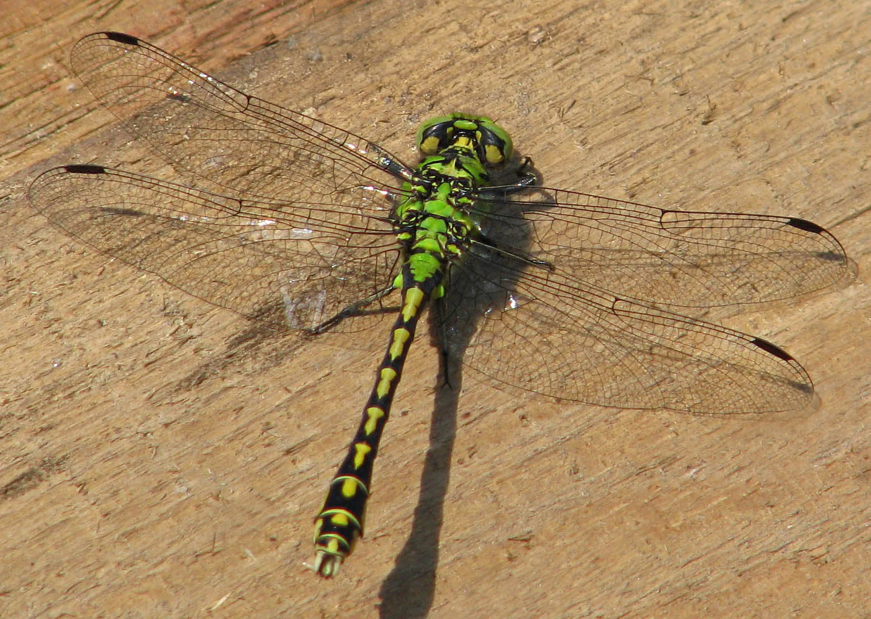
A green snaketail dragonfly with lime green and black patterned body and translucent wings resting on light brown wood.
A green snaketail dragonfly, Ophiogomphus cecilia, resting on a wooden surface.

Crailsheimer Hart und Reusenberg history and protected-area timeline

The site was identified in 2015 by the Regierungspräsidium Stuttgart as a candidate Special Area of Conservation under the European Habitats Directive. After a formal assessment and designation process, the Regierungspräsidium issued an ordinance on 30 October 2018 establishing the site as an Area of Community Importance, with the regulation entering into force on 11 January 2019.

The landscape itself, however, has a much older history shaped by centuries of agricultural use. Juniper heaths, dry grasslands, and traditional orchards reflect historical land management practices such as grazing, hay-making, and fruit cultivation, which have maintained open habitats that would otherwise have become forested. The doline fields of the gypsum keuper are the product of long-term geological processes interacting with this human land use, and the near-natural state of parts of the Jagst river is the result of limited channelization in this section of the valley.

Crailsheimer Hart und Reusenberg landscape and geographic character

The protected area sits in the transition between several major natural regions of Baden-Württemberg, including the Schwäbisch-Fränkische Waldberge (No. 108), the Frankenhöhe (No. 114), and the Hohenloher-Haller Ebene (No. 127). These natural regions belong to the larger units of the Schwäbisches Keuper-Lias-Land, Fränkisches Keuper-Lias-Land, and the Neckar- und Tauber-Gäuplatten, giving the area a transitional geological character.

Geologically, the site is dominated by gypsum keuper, a substrate that dissolves to form sinkholes and dolines, creating the distinctive small-scale surface relief visible across the slopes. The Jagst valley cuts through this terrain, producing a contrast between open, sun-exposed slope habitats in dry grasslands and juniper heaths and the more sheltered, humid conditions along the river. In wetter pockets, calcareous springs and small peat-forming areas support distinct vegetation communities. The combination of doline formations, slope grasslands, traditional orchards, and floodplain forest makes the landscape visually varied despite its limited overall size.

Crailsheimer Hart und Reusenberg ecosystems, habitats, and plant life

Ecologically, Crailsheimer Hart und Reusenberg is defined by an unusually dense concentration of small habitat types within a single protected boundary. Warm, dry calcareous substrates support juniper heaths (Wacholderheiden), species-rich calcareous dry grasslands, and submontane mat-grass swards. Cool, wet valley bottoms contrast sharply with these dry slopes, holding molinia meadows on calcareous or peaty soils, calcareous fens, calcium-rich spring mires, and dystrophic as well as eutrophic standing waters.

The site's aquatic component is significant despite its modest scale. Small standing waters range from dystrophic to eutrophic in character, while the Jagst river includes sections classified as natural flowing waters with Ranunculus vegetation and stretches with muddy pioneer-vegetated banks. Oak-hornbeam forests in both sub-Atlantic and more continental variants add a wooded element to the mosaic. Alluvial forests of alder, ash, and willow line the Jagst, tying the river and its floodplain into the broader habitat network.

Habitat transitions are key to the site's ecological character. Dry hillside juniper heaths meet moist valley meadows, calcareous springs emerge at the foot of gypsum slopes, and dolines capture surface water to form isolated wet pockets. The result is a finely structured landscape in which small changes in geology and hydrology create pronounced differences in vegetation.

Crailsheimer Hart und Reusenberg wildlife and species highlights

Wildlife of conservation concern within the site includes the Eurasian beaver (Castor fiber) along the Jagst riparian corridor, and the yellow-bellied toad (Bombina variegata), an amphibian associated with small water bodies and floodplain habitats. The bullhead (Cottus gobio), a small freshwater fish sensitive to water quality, is present in the Jagst and its tributaries.

Invertebrate diversity is a notable feature. The site supports the dark green large blue butterfly (Maculinea nausithous, now often classified as Phengaris nausithous), a species tied to wet meadows where its host gentians and ant colonies occur. The green snaketail dragonfly (Ophiogomphus cecilia) inhabits cleaner stretches of the Jagst, while the stone crayfish (Austropotamobius torrentium) is recorded in the area. The narrow-mouthed whorl snail (Vertigo angustior), a small mollusc of wet calcareous habitats, also occurs here, completing a substantial freshwater and wetland fauna of European interest.

Crailsheimer Hart und Reusenberg conservation status and protection priorities

Crailsheimer Hart und Reusenberg contributes to the European Natura 2000 network as a designated Special Area of Conservation under the EU Habitats Directive. Its conservation value lies primarily in the combination of habitat types and species listed in Annex I and Annex II of the directive, including juniper heaths, calcareous dry grasslands, alluvial forests, and specific habitat types for rare freshwater species.

The overlap between the FFH site and several landscape protection areas (Landschaftsschutzgebiete) enhances its long-term protection, and two nature reserves: the Reußenberg nature reserve and the Wacholderberg-Geigerswasen nature reserve; lie at least partly within its boundaries, reinforcing landscape-level protection for juniper-heath and dry-grassland habitats.

Maintenance of the site's conservation value depends largely on the continuation of extensive traditional land uses such as grazing, meadow management, and orchard cultivation. Without these practices, dry and open habitats would gradually succeed toward forest, while wet meadows require active management to prevent scrub encroachment and loss of habitat structure for the species they support.

Crailsheimer Hart und Reusenberg cultural meaning and human context

The cultural landscape of Crailsheimer Hart und Reusenberg reflects centuries of agricultural use in the Jagst valley. Traditional orchards, particularly the Streuobstwiesen visible near small settlements such as Hörbühl, are emblematic of regional land use. Juniper heaths and dry grasslands, while often viewed today as natural features, are themselves the product of historical grazing and hay-making that prevented forest encroachment.

Small villages such as Crailsheim, Jagstzell, Satteldorf, Kreßberg, Stimpfach, and Frankenhardt; with Crailsheim municipality including the largest share of the site by area; are intimately tied to the maintenance of these landscapes. Local farming communities continue to shape the protected area's habitat character through their choices of cultivation, grazing, and orchard management, making the site not only an ecological reserve but also a working cultural landscape.

Top sights and standout views in Crailsheimer Hart und Reusenberg

Crailsheimer Hart und Reusenberg is distinguished by a high habitat diversity concentrated in a relatively small area, combining juniper heaths, calcareous dry grasslands, wet meadows, calcareous springs, doline-rich gypsum terrain, and near-natural stretches of the Jagst river. The site supports several species of European conservation concern, including beaver, yellow-bellied toad, bullhead, stone crayfish, and the dark green large blue butterfly.

Its layered protection status; from Natura 2000 designation through landscape protection areas to two embedded nature reserves; gives the site a strong role in maintaining habitat connectivity in the transition zone between the Schwäbisch-Fränkische Waldberge and the Frankenhöhe.

Best time to visit Crailsheimer Hart und Reusenberg

The different habitat types of the site offer varied seasonal appeal. Late spring and early summer are particularly rewarding for botanical interest, as calcareous dry grasslands, juniper heaths, and species-rich meadows come into flower. Early summer is also a good period for observing dragonflies and butterflies, including the dark green large blue butterfly in suitable wet meadow habitats.

Autumn brings traditional orchards into productivity and gives the broader forest and orchard landscape warm, colorful tones. Winters are typically quiet and cool, though they can be a good time for observing waterbirds and beaver activity along the Jagst. Hydrological conditions, particularly the filling of dolines and seasonal dynamics of wet meadows, shape much of the seasonal character of the valley.

Monthly climate preview

Long-term representative point measurements for temperature and precipitation patterns

Crailsheimer Hart und Reusenberg Climate Normals and Annual Temperature Rhythm

Representative coordinate records outline the measured annual temperature and precipitation rhythm across twelve baseline months for Crailsheimer Hart und Reusenberg. Detailed monthly climate profiles provide deeper analytical context for long-term averages without relying on live forecasts.
Annual mean9 °C
-1 °C18 °C
Jan-1°
Feb
Mar
Apr
May13°
Jun16°
Jul18°
Aug18°
Sep14°
Oct
Nov
Dec
Warmest month
July

18.4 °C

Coolest month
January

-1 °C

Wettest month
July

3 mm/day

Driest month
April

1.6 mm/day

Park location guide

Geography guide, regional context, and park location map for Crailsheimer Hart und Reusenberg

Crailsheimer Hart und Reusenberg park geography, regions, and map view in Germany

Understand where Crailsheimer Hart und Reusenberg sits in Germany through a broader geographic reading of the surrounding landscape, nearby location context, and its mapped position within the national park landscape.

How Crailsheimer Hart und Reusenberg fits into Germany

Germany is a federal republic in Western and Central Europe with a population of over 83 million across sixteen constituent states. It is Europe's largest economy by nominal GDP and a major global exporter and importer. The capital is Berlin, and the country borders Denmark, Poland, Czech Republic, Austria, Switzerland, France, Luxembourg, Belgium, and the Netherlands.

Wider geography shaping Crailsheimer Hart und Reusenberg in Germany

Germany is located in Western and Central Europe, spanning 357,022 km². It borders Denmark to the north, Poland and the Czech Republic to the east, Austria and Switzerland to the south, and France, Luxembourg, Belgium, and the Netherlands to the west. The country has coastlines on the Baltic Sea and North Sea to the north, with the Alps located in the southern region.

Map view of Crailsheimer Hart und Reusenberg

Use this park location map to pinpoint Crailsheimer Hart und Reusenberg in Germany, understand its exact geographic position, and read its mapped placement within the surrounding landscape more clearly.

Pigeon | © OpenStreetMap contributors

Location context for Crailsheimer Hart und Reusenberg

Baden-Württemberg
Recorded earthquake history

Explore Historical Earthquake Records for Crailsheimer Hart und Reusenberg

Browse the comprehensive catalogue of recorded seismic events associated with the geography of Crailsheimer Hart und Reusenberg. Use this data to track historical earthquake patterns and epicentre proximity within the surrounding Baden-Württemberg landscape through MoriAtlas.

Crailsheimer Hart und Reusenberg Earthquake Records

Catalogued events

5 events

Strongest magnitude

Magnitude 4.1

Most recent event

Aug 1, 1999

This history includes earthquakes recorded inside the park or within 50 km of its borders

Visualizing gypsum keuper terrain, juniper heaths, and Jagst valley habitats

Crailsheimer Hart und Reusenberg Landscape Photos and Protected Area Scenery

Visual records capture the distinctive topography of Crailsheimer Hart und Reusenberg, featuring juniper heaths, calcareous grasslands, and gypsum sinkhole formations. Photographic documentation reveals the environmental character of the protected area, providing clear visual reference for its mosaic of slope habitats and valley ecosystems.

A green snaketail dragonfly with lime green and black patterned body and translucent wings resting on light brown wood.

A wide view of a rolling green meadow featuring scattered blooming fruit trees and a small forest in the background under a clear blue sky.

Park atlas

Compare regional geography, connected valley reserves, and adjacent habitats in Baden-Württemberg

Exploring Parks Near Crailsheimer Hart und Reusenberg and Surrounding Protected Landscapes

Browse other protected areas and nature reserves located near Crailsheimer Hart und Reusenberg across the Jagst river basin. Compare regional park geography and adjacent valley landscapes to expand your understanding of local conservation networks.
Watercolor painting of a river winding through a gentle green valley with distant hills.
Nature reserveBaden-Württemberg
Park boundaries overlap#1 closest

Northwest

Jagst bei Kirchberg und Brettach Nature Reserve: Protected River Landscapes of Baden-Württemberg

River valleys, calcareous grasslands, and limestone terrain in Southwestern Germany.

The Jagst bei Kirchberg und Brettach nature reserve preserves a diverse corridor of natural river meanders, floodplain meadows, and beech forests. Situated in the Baden-Württemberg region, this protected area spans nearly 900 hectares, offering a rich study in limestone geology and riparian ecology within the Kocher-Jagst plains.

Area
8.93 km²
Established
2019
Relief
Upland
Climate
Temperate
A soft watercolor illustration of rolling hills and gentle terrain in shades of pale green and muted earth tones against a white background.
Protected landscapeMittelfranken
0 km away#2 closest

Northeast

Naturpark Frankenhöhe Protected Landscape: Geography, Map, and Regional Conservation Context

Explore the diverse natural terrain of the Mittelfranken region in Bavaria.

Naturpark Frankenhöhe serves as a significant protected landscape in western Mittelfranken, encompassing a unique mosaic of forests, vineyards, and agricultural valleys. This geographic entity is shaped by the European Main Watershed, where rivers divide between the Rhine and Danube systems. Its terrain provides a study in transitions, from higher forested crests to open orchard meadows that define the local Bavarian countryside.

Area
1,104.06 km²
Established
1974
Relief
Mixed relief
Climate
Temperate
A soft watercolor painting of a river valley with green fields, distant hills, and a prominent tree in the foreground on the right.
Protected areaBaden-Württemberg
1.6 km away#3 closest

West

Bühlertal Vellberg-Geislingen: Protected River Valley and Karst Geography

A concentrated habitat corridor in Baden-Württemberg

This protected area follows the Bühler river through a series of tight meanders and dramatic limestone formations. The landscape is characterized by a transition from wet floodplain woods and tall-herb fringes to dry calcareous grasslands and hillside forests. Covering over 800 hectares, the site serves as a vital ecological link across the Kocher-Jagst plains and the forested ridges of the Schwäbisch-Fränkische Waldberge.

Area
8.474 km²
Established
2019
Relief
Upland
Climate
Temperate
A soft watercolor painting of a calm reservoir surrounded by light green trees and low vegetation.
Protected landscapeBaden-Wuerttemberg
About 3.2 km away#4 closest

South

Speicherbecken Orrot: Geography and Protected Landscape Analysis in Baden-Wuerttemberg

Reservoir, valley terrain, and wetland mapping

Speicherbecken Orrot serves as a significant example of a protected valley landscape within the Ostalbkreis. The area centers on the Orrotsee reservoir, surrounded by a mosaic of fish ponds, wet meadows, and forested slopes. Our mapping provides a clear view of the park boundaries and the ecological features that distinguish this wetland geography from the surrounding upland terrain.

Area
0.567 km²
Established
1968
IUCN
V
A wide watercolor illustration showing a landscape of rolling green hills and trees under a pastel pink and yellow sky.
Protected landscapeGermany
About 24 km away#5 closest

North

Niederstetten (Landschaftsschutzgebiet) Protected Landscape Map and Regional Terrain Data

Protected landscape and topographic features in Baden-Württemberg

Covering 1,786 hectares, the Niederstetten (Landschaftsschutzgebiet) serves as a vital protected landscape within the Hohenlohe region. It is recognized for its deeply incised side valleys, stream-fed corridors, and traditional dry-stone wall boundaries that define this portion of the German countryside.

Area
17.86 km²
Established
1992
Relief
Upland
Climate
Temperate
Faint watercolor illustration of rolling green hills and a pinkish foreground against a white background.
Protected areaBaden-Württemberg
28 km away#6 closest

South

Albtrauf Donzdorf-Heubach: Protected Escarpments and Karst Terrain in the Swabian Alb

Natura 2000 protected area in eastern Baden-Württemberg

The Albtrauf Donzdorf-Heubach site comprises eight protected parcels along the Swabian Alb. Its geography is defined by steep limestone cliffs, dissected valleys, and extensive karst systems that support specialized biodiversity. This protected landscape highlights the complex interaction between Upper Jurassic geological formations and traditional land-use patterns across the Göppingen and Ostalbkreis districts.

Area
25.333 km²
Established
2019
Relief
Highland
Climate
Temperate
A watercolor illustration of rolling hills in shades of purple and green against a white background.
Nature reserveBaden-Württemberg
28 km away#7 closest

Northwest

Jagsttal Dörzbach-Krautheim Protected Area: Landscape Geography and Atlas Map Context

Nature reserve featuring karst features and riparian corridors

Spanning the Jagst river valley in Baden-Württemberg, Jagsttal Dörzbach-Krautheim showcases a sophisticated mosaic of dry calcareous grasslands and wet floodplain woodlands. This atlas entry focuses on the park boundary geography, identifying the intersection of limestone scree slopes, plateau forests, and karst caves that create its distinct ecological profile. Gain a comprehensive view of how these features form a vital conservation link within the regional river network.

Area
17.502 km²
Established
2005
Relief
Mixed relief
Climate
Temperate
A horizontal watercolor painting showing rolling green meadows with small clusters of trees and soft hills in the background on a white background.
Protected areaBaden-Württemberg
29 km away#8 closest

South

Albuchwiesen: A Protected Landscape of Wetlands and Historical Grasslands on the Swabian Alb

Geographic atlas of the smallest Habitats Directive site in Baden-Württemberg

Albuchwiesen represents a critical refuge for wetland biodiversity outside the Brenz valley, characterized by its scattered parcels of calcareous dry grasslands and wet meadow systems. The area preserves essential remnants of historical land use on the Ostalb, including distinct clay-lined ponds and transitional mires that define this localized plateau terrain.

Area
51.1 km²
Established
2019

Common questions about visiting, size, designation, and location context for Crailsheimer Hart und Reusenberg

Crailsheimer Hart und Reusenberg FAQs for park facts, access, geography, and protected area context

Find quick answers about Crailsheimer Hart und Reusenberg, including protected-area facts, park geography, trail and visitor context, and how the park fits into its surrounding country and regional landscape.
MoriAtlas Explorer

Continue Your Protected Areas Search Across the Global Atlas

Deepen your exploration by continuing the structured search for national parks and protected areas worldwide. Utilize the comprehensive filtering capabilities to compare different conservation landscapes and refine your understanding of global park geography. Discover more about the distribution and characteristics of protected natural areas.

Global natural geography