
Mori Atlas logo
Protected landscapeCuatro Islas Protected Landscape/Seascape

Mapping the coral reef islands and marine ecosystems of the Camotes Sea near Leyte

Cuatro Islas Protected Landscape/Seascape: A Comprehensive Geographic Atlas and Protected Area Map

Cuatro Islas Protected Landscape/Seascape represents a significant marine and terrestrial protected area located off the western coast of Leyte in the Philippines. This atlas entry provides a detailed view of the four distinct islands, which include raised coral reef structures and low-lying sandy cays, all set within the ecologically diverse waters of the Camotes Sea. Analyze the complex interplay between the white sand coastlines, fossilized reef formations, and the expansive coral reef systems that define this protected territory.

islandscoral reefsmarine protected areasmall islandssea turtle nestingdolphins
Stylized vector art of a valley with steep canyon walls, pine forests, multiple waterfalls, and a rising sun in the background.

Cuatro Islas Protected Landscape/Seascape

Protected landscape

Park overview

Structured park overview, official facts, and landscape profile for Cuatro Islas Protected Landscape/Seascape

Cuatro Islas Protected Landscape/Seascape park facts, protected area profile, and essential visitor context

Review the core facts for Cuatro Islas Protected Landscape/Seascape, including designation, size, terrain, visitor scale, habitats, and operating context in one park-focused overview.

About Cuatro Islas Protected Landscape/Seascape

Cuatro Islas Protected Landscape/Seascape is a small but ecologically distinctive protected area in the Philippines that combines island terrestrial habitat with surrounding marine ecosystems. The protected area lies in the Camotes Sea, west of the main Leyte coastline, and is named after a cluster of four small islands: Digyo, Apid, Mahaba, and Himokilan. These islands, together with their encircling reefs and waters, form the core of a protected landscape and seascape that was officially established on April 23, 2000. The setting reflects a classic tropical small-island environment. Apid and Mahaba are formed from uplifted coral reefs that have emerged above sea level and become vegetated with dense shrubs and small trees, surrounded by white sand beaches and notable fossilized coral formations. Digyo is a lower, sand-dominated islet built from accumulated coral material and bearing a few coconut palms. There are no freshwater sources on any of the four islands, underscoring their small size and their geological origins from coral rather than from larger landforms. The marine dimension is equally central to the park's value. The reefs circling the islands host an exceptionally high diversity of stony corals, and the open waters attract marine mammals and provide habitat for sea turtles and reef sharks. Administratively, the islands lie within the municipalities of Inopacan and Hindang, both in the province of Leyte, placing the protected area firmly within the Eastern Visayas region of the Philippines. Despite the small overall footprint of the emergent land, the inclusion of surrounding seascape brings the total protected area to approximately 125 square kilometers, making it a genuinely integrated land-and-sea conservation site.

Quick facts and research context for Cuatro Islas Protected Landscape/Seascape

Cuatro Islas Protected Landscape/Seascape is a combined land and marine sanctuary located in the Camotes Sea off the western coast of Leyte province in the Eastern Visayas region of the Philippines. It was formally established on April 23, 2000, and covers an area of approximately 125 square kilometers. The protected area is named after the four small islands of Digyo, Apid, Mahaba, and Himokilan, which administratively fall within the municipalities of Inopacan and Hindang. The site sits roughly 130 kilometers west of Tacloban City, and the islands are accessible from the mainland via Baybay City or a roughly two-hour boat crossing from Ormoc City. The surrounding reefs are recorded as hosting 287 species of stony corals, and the islands have no freshwater sources, reflecting their small size and coral-based geology.

Protection and recognition

Documented protection scope and international designation records

Cuatro Islas Protected Landscape/Seascape Protection Status and Recognition

Cuatro Islas Protected Landscape/Seascape encompasses a mixed protection scope managed under established conservation frameworks. Official datasets track the documented status, administrative boundaries, and international recognition metrics for the protected area.

Protection details

Protection scope
Mixed
WDPA ID
306495
Park context

Deeper park guide and search-rich context for Cuatro Islas Protected Landscape/Seascape

Cuatro Islas Protected Landscape/Seascape history, landscape, wildlife, and travel context

Explore Cuatro Islas Protected Landscape/Seascape through its history, landscape character, ecosystems, wildlife, conservation priorities, cultural context, and seasonal travel timing in a structured park guide built for atlas discovery and search intent.

Why Cuatro Islas Protected Landscape/Seascape stands out

Cuatro Islas is best known for its compact grouping of four small coral-derived islands and the rich marine ecosystem that surrounds them. Apid and Mahaba are particularly notable as raised former coral reefs now bearing dense shrub vegetation and fringed by white sand beaches, while Digyo stands out as a low coral sand islet with scattered coconut palms. The entire area is recognized for fossilized coral formations that document the islands' geological origins. The surrounding marine environment defines the park's identity as much as the islands themselves. Divers and researchers highlight its biodiversity, including more than 280 recorded stony coral species, frequent sightings of dolphins and short-finned pilot whales, nesting populations of green sea turtles and hawksbill turtles, and several species of reef sharks around the coral formations.
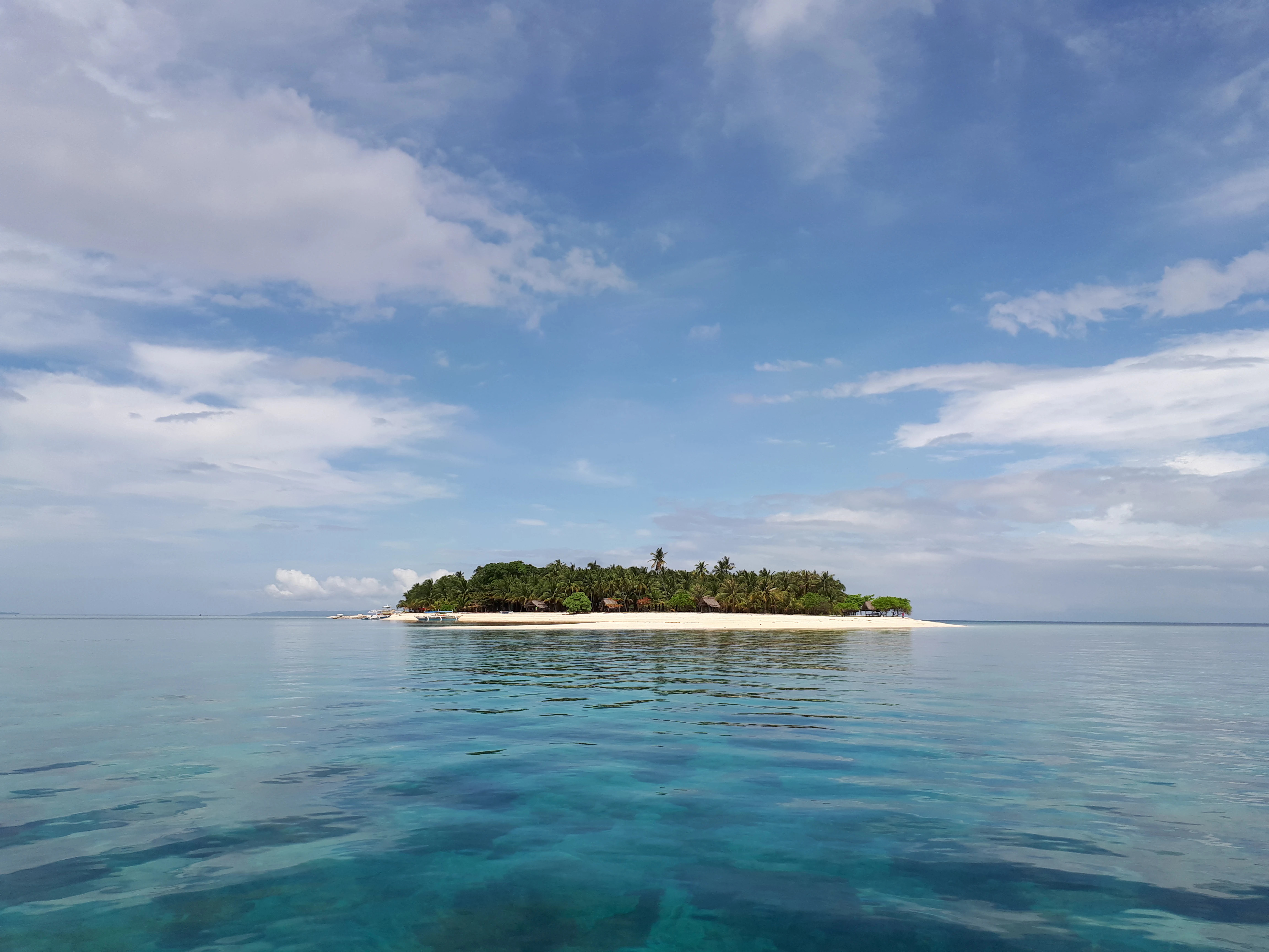
A small tropical island with a white sand beach and dense green vegetation sits in the middle of calm, clear blue water under a partly cloudy sky.
A view of Digyo Island, one of the four islands within the Cuatro Islas Protected Landscape and Seascape.

Cuatro Islas Protected Landscape/Seascape history and protected-area timeline

Cuatro Islas Protected Landscape/Seascape was formally established as a combined land and marine protected area on April 23, 2000, under Philippines protected-area legislation. The designation reflects a recognition of both the geological and ecological significance of the four islands themselves and the biodiversity of their surrounding coral reef and pelagic waters. By 2002, the islands supported a small resident population of 603 people living in 115 households, indicating that the protected area overlays inhabited small-island communities rather than purely uninhabited territory. The site's inclusion in international databases, such as the World Database on Protected Areas, and its involvement in European-supported island rehabilitation projects point to broader regional and international interest in its conservation beyond the moment of its original designation.

Cuatro Islas Protected Landscape/Seascape landscape and geographic character

The physical landscape of Cuatro Islas is defined by its coral geology. Apid and Mahaba are raised former coral reefs that have been lifted above sea level, exposing fossilized coral structures that document the islands' formation over geological time. These two larger islands support a dense cover of shrubs and small trees, and their coastlines are characterized by white sand beaches. Digyo is a very different type of feature: a low islet formed mainly from accumulated coral sand, with only sparse vegetation consisting of a few coconut palms. Himokilan completes the group. None of the four islands carries any freshwater source, a defining limitation of their physical geography. Around the islands, the underwater landscape is equally important. Smaller coral reefs fringe the group, transitioning into the open waters of the Camotes Sea. This combination of raised reef islands, sandy cays, fringing reefs, and surrounding pelagic waters creates a layered island-and-seascape that determines both the visual character and the ecological value of the site.

Cuatro Islas Protected Landscape/Seascape ecosystems, habitats, and plant life

Cuatro Islas Protected Landscape/Seascape protects a layered tropical marine and small-island ecosystem. The terrestrial component is shaped by coral-derived substrates, supporting shrubland vegetation and isolated coconut palms rather than closed-canopy forest. Because none of the four islands has a freshwater source, the terrestrial habitats are fundamentally dry, low, and adapted to nutrient-limited, salt-influenced conditions. The dominant ecological feature, however, is marine. The fringing reefs around the islands are recorded as supporting 287 species of stony corals, indicating an exceptionally diverse reef-building coral community relative to the area's size. The combination of reef habitat and adjacent open water creates a productive system that links benthic coral communities to pelagic species. The protected area effectively functions as a tightly integrated reef-and-island habitat complex within the Camotes Sea, a regional sea of the central Philippines rich in coral ecosystems.

Cuatro Islas Protected Landscape/Seascape wildlife and species highlights

The wildlife profile of Cuatro Islas is strongly marine. Dolphins are a regularly noted presence in the surrounding waters, including Fraser's dolphin and the spinner dolphin, while the short-finned pilot whale is also documented. Sea turtles are central to the park's conservation identity: Digyo supports nesting activity of the green sea turtle, while the hawksbill turtle also nests in the area, making the islands important for reproduction by both species. Reef-associated sharks add to the marine biodiversity around the islands. The grey reef shark, whitetip reef shark, and blacktip reef shark have been observed patrolling the coral formations, alongside thresher sharks in the broader waters. On the terrestrial side, vegetation is limited to drought-tolerant shrubs, small trees, and coconut palms, with the small-island environment precluding larger terrestrial fauna but offering important seabird and migratory coastal bird habitat.

Cuatro Islas Protected Landscape/Seascape conservation status and protection priorities

Cuatro Islas is significant for conservation because it integrates protection of coral reef ecosystems, sea turtle nesting habitat, and marine mammal habitat into a single combined land-and-sea framework. Its designation as a Protected Landscape/Seascape, rather than a purely terrestrial reserve, reflects recognition that the islands and their surrounding waters function as a single ecological unit. The reef system, with 287 recorded stony coral species, is a particularly important conservation asset for the region. The islands' turtle nesting sites, especially on Digyo, give the protected area direct reproductive habitat value for green and hawksbill turtles. The consistent presence of dolphins and pilot whales in the surrounding waters highlights the offshore habitat's importance. Inclusion in the World Database on Protected Areas and participation in multi-country island rehabilitation initiatives have helped connect the site's conservation work to broader Philippine and international biodiversity efforts.

Cuatro Islas Protected Landscape/Seascape cultural meaning and human context

The Cuatro Islands are inhabited small islands, with 603 residents recorded across 115 households in 2002, distributed between the municipalities of Inopacan and Hindang. This means the protected area overlays a living coastal community whose livelihood, daily life, and identity are tightly bound to the sea and to small-island living. The islands' lack of freshwater and their reliance on coconut cultivation and marine resources reflect a traditional pattern of adaptation to low coral islets in the Philippine seas. The cultural context of the wider region is rooted in the coastal communities of western Leyte and the Camotes Sea, where small-island fishing, boat travel, and seasonal movement between islands and the mainland have long shaped local life. The islands' modest size and their multi-municipality administrative split means they sit at the intersection of two local communities rather than forming a single dominant cultural center of their own.

Top sights and standout views in Cuatro Islas Protected Landscape/Seascape

Cuatro Islas Protected Landscape/Seascape combines in a compact area the distinct landscapes of raised reef islands, a coral sand cay, white sand beaches, and an exceptionally diverse reef system. The 287 recorded stony coral species around the islands make the surrounding waters ecologically significant far beyond the modest land area. Sea turtle nesting on Digyo, and the presence of multiple dolphin species and reef sharks, give the protected area an unusually rich animal life for its size. The islands' near-pristine coral vegetation, visible fossilized reef formations, and lack of freshwater sources together create a distinctive and easily understood natural profile. The site rewards both above-water appreciation of small-islet scenery and underwater exploration of coral and pelagic wildlife, making it a compact showcase of Philippine small-island marine conservation.

Best time to visit Cuatro Islas Protected Landscape/Seascape

The climate around Cuatro Islas follows the typical tropical pattern of the central Philippines, with a drier season and a wetter season that influences sea conditions and visibility. Calm seas and clearer skies during the drier months generally favor boat travel to the islands, snorkeling on the fringing reefs, and clearer underwater visibility for appreciating the site's coral diversity. The wetter months may bring rougher seas, reduced visibility, and heavier rainfall, though the islands themselves remain largely unaffected by terrestrial seasonal change because of their coral-based, low-vegetation character. Sea turtle nesting activity on Digyo and the seasonal movement patterns of dolphins and pilot whales in the surrounding Camotes Sea also shape the wildlife experience across the year, so visitors interested in specific animals may want to time their trip around broader marine wildlife seasons rather than fixed calendar months.
Monthly climate preview

Long-term representative temperature and precipitation rhythm across annual cycles

Cuatro Islas Protected Landscape/Seascape Climate Normals and Weather by Month

Representative coordinate records show measured average temperatures ranging from 26.79 °C to 29.03 °C alongside variable monthly precipitation rates across the landscape. Examining the full twelve-month profile reveals detailed baseline patterns for sustained geographical comparison.
Annual mean28 °C
27 °C29 °C
Jan27°
Feb27°
Mar27°
Apr28°
May29°
Jun29°
Jul28°
Aug28°
Sep28°
Oct28°
Nov28°
Dec28°
Warmest month
May

29 °C

Coolest month
February

26.8 °C

Wettest month
October

7 mm/day

Driest month
April

2.5 mm/day

Park location guide

Geography guide, regional context, and park location map for Cuatro Islas Protected Landscape/Seascape

Cuatro Islas Protected Landscape/Seascape park geography, regions, and map view in Philippines

Understand where Cuatro Islas Protected Landscape/Seascape sits in Philippines through a broader geographic reading of the surrounding landscape, nearby location context, and its mapped position within the national park landscape.

How Cuatro Islas Protected Landscape/Seascape fits into Philippines

The Philippines, officially the Republic of the Philippines, is an archipelagic nation in Southeast Asia comprising approximately 7,641 islands categorized into three main geographical divisions: Luzon, Visayas, and Mindanao. Located in the western Pacific Ocean, it shares maritime borders with Taiwan, Japan, Palau, Indonesia, Malaysia, Vietnam, and China. Manila serves as the capital city, while Quezon City is the most populated city, both within Metro Manila.

Wider geography shaping Cuatro Islas Protected Landscape/Seascape in Philippines

The Philippines is an archipelagic nation in Southeast Asia, positioned in the western Pacific Ocean. Its islands are bounded by the South China Sea to the west, Philippine Sea to the east, and Celebes Sea to the south. The country shares maritime borders with Taiwan to the north, Japan to the northeast, Palau to the east and southeast, Indonesia to the south, Malaysia to the southwest, Vietnam to the west, and China to the northwest.

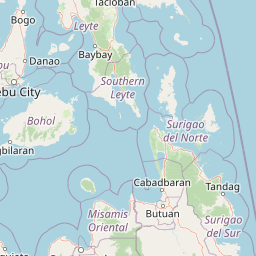
Map view of Cuatro Islas Protected Landscape/Seascape

Use this park location map to pinpoint Cuatro Islas Protected Landscape/Seascape in Philippines, understand its exact geographic position, and read its mapped placement within the surrounding landscape more clearly.

Pigeon | © OpenStreetMap contributors

Location context for Cuatro Islas Protected Landscape/Seascape

Leyte

Visual reference for raised coral reefs, white sand cays, and marine habitats

Cuatro Islas Protected Landscape/Seascape Photos and Scenic Island Landscapes

Visual records document the raised coral terrain, shrub vegetation, and sandy cays that define the four distinct islands. Photographic archives reveal the marine habitats, fringing coral formations, and coastal scenery protected within the Camotes Sea.

A small tropical island with a white sand beach and dense green vegetation sits in the middle of calm, clear blue water under a partly cloudy sky.

Park atlas

Compare adjacent marine reserves, island habitats, and coastal conservation zones

Parks Near Cuatro Islas Protected Landscape/Seascape and Regional Protected Areas

Browse protected areas near Cuatro Islas Protected Landscape/Seascape to compare surrounding marine ecosystems and coastal geography. Regional park exploration reveals connected island habitats and diverse coral landscapes across the broader maritime territory.
National parkPhilippines
About 41 km away#1 closest

Northeast

Kuapnit Balinsasayao National Park: Philippines Old-Growth Forest and Endemic Wildlife Atlas

Explore protected landscape boundaries and mountainous terrain on Leyte Island.

Kuapnit Balinsasayao National Park stands as a key protected area within the Philippines, distinguished by its mature old-growth forests and its critical role in conserving endemic bird species unique to the Eastern Visayas. Located on Leyte Island within the mountainous terrain of the Anonang-Lobi Mountain Range, the park's protected landscape identity is central to understanding its geographic significance. This park offers a valuable entry point for exploring the mapped natural features and conservation importance of protected areas across the Philippine archipelago.

Area
3.64 km²
Established
1937
IUCN
V
Relief
Mountain
A watercolor painting showing a panoramic view of a lush wetland landscape with gentle green hills in the distance, a winding stream, and tall grasses and pink wildflowers in the foreground.
Wildlife reserveCentral Visayas
About 72 km away#2 closest

Southwest

Olango Island Wildlife Sanctuary: Coastal Protected Area and Migratory Bird Habitat in Central Visayas

Explore the interconnected mudflats, reefs, and mangrove forest ecosystems

Olango Island Wildlife Sanctuary stands as a key protected landscape in the Central Visayas, defined by its vast tidal flats and critical role in international bird migration patterns. This site features a unique mosaic of salt marshes, seagrass beds, and coral reef systems that support diverse coastal life within the low-lying terrain of the Olango Island Group.

Area
10.3 km²
Established
1992
Relief
Lowland
Climate
Tropical
National parkPalo
About 81 km away#3 closest

Northeast

MacArthur Landing Memorial National Park: Protected Area Geography & Map Context

Explore the mapped boundaries of this national park in Palo, Philippines.

This entry details MacArthur Landing Memorial National Park, a protected national park located near Palo, Philippines. It focuses on its identity as a mapped landscape and a distinct protected area, offering insights into its geographic context and atlas presence. Understanding this park involves exploring its mapped boundaries and its contribution to the regional protected area landscape, providing a factual basis for geographic discovery.

Area
0.068 km²
Established
1977
Relief
Lowland
Climate
Tropical
Protected landscapeBohol
About 108 km away#4 closest

Southwest

Rajah Sikatuna Protected Landscape: Mapping the Limestone Forest of Bohol, Philippines

A vital protected area of karst ridges and endemic forest habitats

Rajah Sikatuna Protected Landscape sits as a premier natural landmark in southern Bohol. This area is defined by its extensive karst topography, significant cave systems, and expansive limestone forests. It serves as an essential ecological anchor for the province, offering a unique perspective on the island's diverse upland geography and natural mountain systems.

Area
104.526 km²
Established
1987
IUCN
V
Relief
Mountain
National parkCebu
About 122 km away#5 closest

West

Guadalupe Mabugnao Mainit Hot Spring National Park: Protected Landscape and Watershed Geography

Explore hot springs, caves, and mapped terrain in Cebu.

Guadalupe Mabugnao Mainit Hot Spring National Park is a protected national park in Cebu, Philippines, recognized for its significant watershed function and unique natural features. Spanning forested highland terrain within the Mantalongon mountain range, the park protects natural hot springs, explored cave systems such as Cave Lorett, and river networks vital to local water supply. Its identity as a protected landscape offers rich opportunities for geographic exploration, mapping its boundaries, and understanding its role within the regional natural terrain and conservation efforts.

Area
0.575 km²
Established
1972
IUCN
V
Relief
Mountain
Marine protected areaVisayas
About 124 km away#6 closest

West

Tañon Strait Protected Seascape: Marine Geography and Protected Landscape Analysis

An expansive marine passage located within the central Visayas island group.

As the largest marine protected area in the Philippines, the Tañon Strait Protected Seascape represents a complex aquatic geography spanning 160 kilometres. Its protected waters serve as a vital corridor for marine biodiversity, linking the northern Visayan Sea to the southern Bohol Sea. This resource provides a detailed look at the strait's maritime boundaries, coastal ecosystems, and the distinct underwater terrain that defines this critical conservation zone.

Area
5,000 km²
Established
1998
IUCN
V
Scope
Marine
A horizontal watercolor painting showing a soft, hazy landscape with a body of water in the foreground, grassy banks, and rolling hills in the distance.
National parkCentral Visayas
About 137 km away#7 closest

Southwest

Panglao Island Protected Seascape: Geographic Atlas and Marine Park Boundaries

A vital protected marine zone in Central Visayas

The Panglao Island Protected Seascape acts as a key site for studying tropical marine biodiversity and karst-driven coastal geography in the Philippines. Spanning the waters around Panglao Island, this protected area features a mosaic of coral reefs, white sand beaches, and offshore limestone islets that provide essential habitats for thousands of mollusk and crustacean species.

Area
91.12 km²
Established
2018
Relief
Mixed relief
Scope
Mixed
Protected landscapeSurigao del Norte
About 144 km away#8 closest

Southeast

Mahaba Island Protected Landscape and Seascape: Regional Geography and Island Reserve

A combined coastal and marine protected area in Surigao del Norte.

Spanning both a flat sandy island and its surrounding sea, Mahaba Island Protected Landscape and Seascape illustrates the integrated conservation model of the Philippines. Discover the layered geography of mangrove-fringed shorelines, interior coconut patches, and marine habitats that form this protected reserve in the Caraga region.

Area
57.04 km²
Established
1991
Relief
Lowland
Climate
Tropical

Common questions about visiting, size, designation, and location context for Cuatro Islas Protected Landscape/Seascape

Cuatro Islas Protected Landscape/Seascape FAQs for park facts, access, geography, and protected area context

Find quick answers about Cuatro Islas Protected Landscape/Seascape, including protected-area facts, park geography, trail and visitor context, and how the park fits into its surrounding country and regional landscape.
MoriAtlas Explorer

Continue Your Protected Areas Search Across the Global Atlas

Deepen your exploration by continuing the structured search for national parks and protected areas worldwide. Utilize the comprehensive filtering capabilities to compare different conservation landscapes and refine your understanding of global park geography. Discover more about the distribution and characteristics of protected natural areas.

Global natural geography