Mori Atlas logo
Protected areaCurlew National Grassland

A detailed geographic look at restored rangeland and protected sagebrush ecosystems in the northern Great Basin

Curlew National Grassland: Exploring the Sagebrush Steppe Landscapes of Southeastern Idaho

Curlew National Grassland represents a significant protected area within southeastern Idaho, featuring a classic sagebrush steppe environment shaped by mid-twentieth-century soil and vegetation rehabilitation. This vast expanse of rolling plains and seasonal drainages offers a unique perspective on the restoration of degraded agricultural lands into stable, semi-arid habitats. By examining the terrain and vegetation patterns of this Intermountain West landscape, visitors can better understand the ecological importance of sagebrush-dependent wildlife and the quiet character of the upper Snake River Plain transition zone.

sagebrush steppenational grasslandsoutheastern IdahoIntermountain Westrangeland restorationsagebrush habitat

Curlew National Grassland

Protected area

Park overview

Structured park overview, official facts, and landscape profile for Curlew National Grassland

Curlew National Grassland park facts, protected area profile, and essential visitor context

Review the core facts for Curlew National Grassland, including designation, size, terrain, visitor scale, habitats, and operating context in one park-focused overview.

About Curlew National Grassland

Curlew National Grassland occupies a slice of southeastern Idaho between the Bear River Range and the deeper valleys of the upper Snake River Plain. Its landscape is defined by rolling, semi-arid rangeland dominated by sagebrush and native grasses, with isolated stands of juniper, washes, and seasonal drainages interrupting the otherwise open terrain. The elevation is moderate and the climate is dry and continental, with cold winters and warm, dry summers that reinforce the region's steppe character.

Like many National Grasslands, Curlew was created from land that was once privately farmed or grazed. During the 1930s, prolonged drought, deflation of topsoil, and the abandonment of unsuitable farmland left large tracts across the Great Plains and Intermountain West exposed to wind and water erosion. Federal programs of the era purchased damaged or marginal land with the goal of replanting it to grass, controlling erosion, and returning it to a more stable vegetative cover. Between 1934 and 1942, the tracts that would become Curlew National Grassland were acquired, mostly from settlers whose dryland farms had failed or whose grazing had degraded native vegetation.

Today the grassland reflects both its rehabilitative origins and its present-day identity as a working landscape. The U.S. Forest Service administers it together with the Caribou-Targhee National Forest, with administrative headquarters in Idaho Falls and a local ranger district office in nearby Malad City. This shared management reflects a broader approach across the western National Grasslands, where grassland units are integrated into the administrative structure of nearby national forests. Although modest in size compared with many of the larger National Grasslands farther east, Curlew still represents a substantial block of sagebrush-steppe habitat and an important example of restoration-era land management in the Intermountain West.

Quick facts and research context for Curlew National Grassland

Curlew National Grassland spans roughly 47,790 acres, or about 193 square kilometers, across parts of Oneida and Power counties in southeastern Idaho. It is administered by the U.S. Forest Service and managed jointly with the Caribou-Targhee National Forest from headquarters in Idaho Falls, with a local ranger district office in Malad City. The land that forms the grassland was acquired between the mid-1930s and early 1940s, primarily to rehabilitate soil and vegetation that had been damaged by dryland farming and grazing. The area lies within the sagebrush steppe ecosystem that is characteristic of the Intermountain West and that supports a distinctive community of wildlife adapted to arid, open country.

Protection and recognition

Explore terrestrial protected area data and official conservation recognition metrics.

Curlew National Grassland Protection Status and Designated Area Record

Curlew National Grassland holds a recorded terrestrial protection scope within the federal protected lands inventory. Official data entries outline baseline designation frameworks and administrative status without external international recognition sources.

Protection details

Protection scope
Terrestrial
Park context

Deeper park guide and search-rich context for Curlew National Grassland

Curlew National Grassland history, landscape, wildlife, and travel context

Explore Curlew National Grassland through its history, landscape character, ecosystems, wildlife, conservation priorities, cultural context, and seasonal travel timing in a structured park guide built for atlas discovery and search intent.

Why Curlew National Grassland stands out

Curlew National Grassland is best known as a sagebrush-steppe landscape that was actively restored after the dust-bowl era, when formerly plowed or overgrazed land was purchased and re-vegetated to stabilize soils. Its identity is tied to the long history of grassland conservation in the American West, and in particular to the chain of National Grasslands created through federal land purchases in Idaho and neighboring states during the 1930s and early 1940s. The grassland also stands out as habitat in a region where intact sagebrush ecosystems are ecologically important. Curlew is associated with the broader sage-steppe environment that supports characteristic wildlife such as mule deer and a variety of sagebrush-associated birds. While it is not defined by dramatic landforms, it represents the kind of wide-open, semi-arid rangeland that defines much of southeastern Idaho and that contrasts sharply with the forested mountains managed as part of the adjacent Caribou-Targhee National Forest.
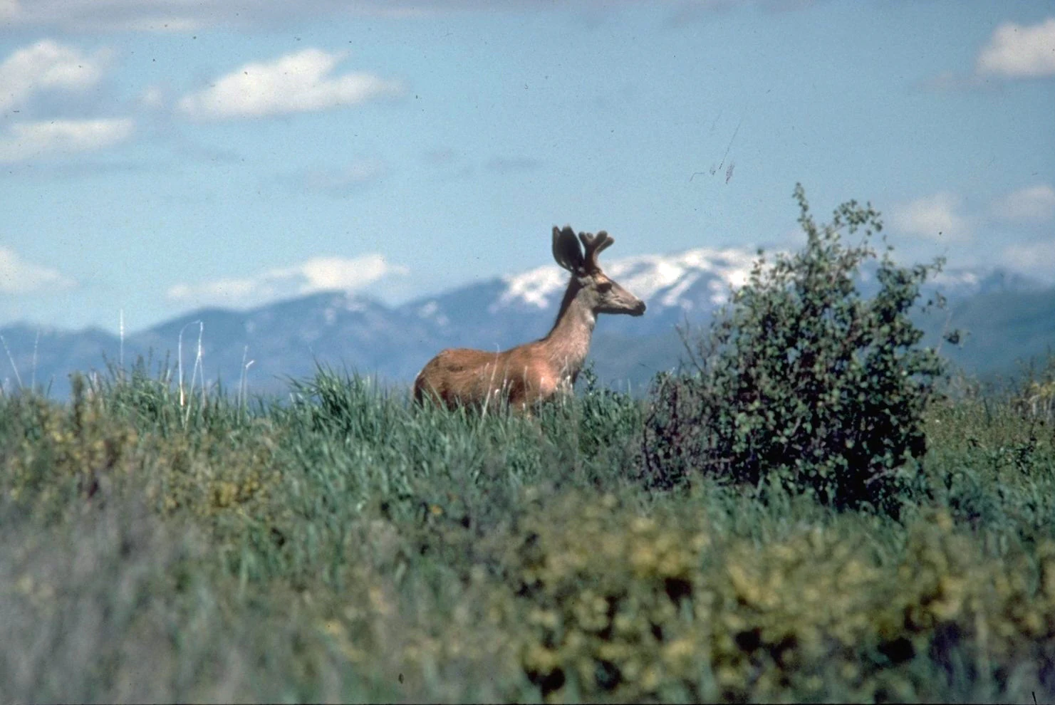
A mule deer standing in tall grasses with snow-capped mountains in the distant background.
A mule deer with velvet antlers standing in the open grasslands of Curlew National Grassland.

Curlew National Grassland history and protected-area timeline

Curlew National Grassland traces its origin to one of the most consequential land-conservation eras in the western United States. In the early 1930s, the combination of severe drought, low agricultural prices, and accumulating soil damage led to widespread farm abandonment across much of the Great Plains, the Great Basin, and the Intermountain West. Many of the dryland farming operations that had been encouraged by homesteading policies proved unsuitable for the region's climate, leaving behind fields vulnerable to wind erosion and dust storms.

Between 1934 and 1942, the federal government purchased tracts of degraded or abandoned land in southeastern Idaho and set them aside for rehabilitation. These purchases became the foundation for what is now Curlew National Grassland. The primary goal of these acquisitions was to improve soil and vegetation conditions on lands that had been damaged by cultivation and grazing, replanting them with perennial grasses and allowing native sagebrush communities to recover. The acquisition period aligned closely with broader New Deal and post-New Deal conservation efforts that produced many of today's National Grasslands across the West.

Over the decades since its establishment, the grassland has been managed as a multiple-use landscape that permits grazing, recreation, and wildlife habitat conservation. Administration was later consolidated with that of the Caribou-Targhee National Forest, and management has increasingly emphasized sagebrush steppe conservation, watershed health, and the habitat needs of sagebrush-dependent wildlife.

Curlew National Grassland landscape and geographic character

The landscape of Curlew National Grassland is defined by the sagebrush steppe that covers much of southeastern Idaho. The terrain consists of gently rolling plains and low uplands, crossed by shallow draws and seasonal drainages that flow toward larger drainages in the region. Elevations are moderate, and the overall impression is of wide-open, sparsely settled rangeland rather than rugged mountains.

Vegetation on the grassland is dominated by big sagebrush and a mix of native bunchgrasses and forbs, with the precise composition varying according to slope, soil type, and past management. In some areas, particularly along shallow drainages and rocky soil patches, Utah juniper and other drought-tolerant trees add vertical structure to the otherwise low-stature vegetation. The result is a semi-arid mosaic of silver-green sagebrush, pale grasses, and exposed soil, framed by distant views toward the surrounding mountain ranges of the region.

The climate supporting this landscape is cold and dry in winter and hot and dry in summer, with relatively limited precipitation. Rainfall patterns strongly favor grasses and woody shrubs over forest cover, which is why coniferous forest on the grassland is sparse and largely confined to the higher or more sheltered sites. The combination of climate, soils, and topography gives Curlew its characteristic steppe appearance: extended views, muted colors, and a sense of quiet openness that is typical of the northern Great Basin and adjacent Snake River Plain transition.

Curlew National Grassland ecosystems, habitats, and plant life

Ecologically, Curlew National Grassland belongs to the sagebrush steppe ecosystem that stretches across much of the Intermountain West. This ecosystem is characterized by an overstory of sagebrush, especially big sagebrush, underlain by a diverse community of perennial bunchgrasses, herbaceous flowering plants, and biological soil crusts that stabilize the surface. Despite its subdued appearance from a distance, sagebrush steppe supports a high degree of plant diversity and a tightly woven web of ecological interactions.

Because the grassland sits at the boundary between the northern Great Basin and the upper Snake River Plain, its vegetation includes species typical of both regions. Native grasses such as wheatgrasses and needlegrasses are important components of the understory, while native forbs contribute seasonal wildflower displays during wetter years. Scattered stands of juniper and other woody vegetation occur on sites where soil depth, moisture, or topography allow tree growth, but the dominant ecological character remains that of an arid, shrub-dominated steppe.

The soils and topography of the grassland reflect the same patterns observed across many southern Idaho rangelands: layers of loess and volcanic-derived sediments overlying older bedrock, shaped by erosion and, in places, by historic cultivation. Biological soil crusts are an important but easily overlooked feature of the system, helping to retain moisture, fix nitrogen, and reduce erosion on otherwise vulnerable surfaces. The result is an ecosystem whose productivity and biodiversity depend heavily on conserving intact soils and on sustaining the ecological processes that maintain the sagebrush overstory.

Curlew National Grassland wildlife and species highlights

Sagebrush steppe ecosystems of the type found at Curlew National Grassland support a distinctive community of wildlife that is in many cases highly dependent on intact sagebrush habitat. Large mammals characteristic of the Intermountain West, including mule deer, are present on the grassland and use the open rangeland for foraging and movement between seasonal ranges. Predators associated with this kind of open, shrub-dominated landscape may also be encountered in the wider area.

The grassland is also significant for birdlife associated with sagebrush. Several species of songbirds, including sagebrush-obligate species that nest exclusively in big sagebrush, rely on this kind of habitat for breeding and wintering. Because sagebrush songbird populations have declined substantially across much of their historic range, areas of intact sagebrush steppe such as Curlew take on added importance for conservation. Raptors, including those that nest in juniper patches or on nearby cliffs, also forage across the grassland as they hunt small mammals.

Small mammals and other ground-dwelling fauna are an integral part of the ecosystem. Sagebrush-dependent rodents and other small mammals form the base of the food web for many predators, and they also influence vegetation patterns through their burrowing and seed predation activities. Reptiles and insects typical of arid Intermountain environments are present as well, completing the faunal profile of a healthy sagebrush-steppe system.

Curlew National Grassland conservation status and protection priorities

Curlew National Grassland matters from a conservation perspective primarily because it preserves a meaningful block of sagebrush steppe at a time when this ecosystem is among the most threatened in North America. Conifer encroachment, historic overgrazing, conversion to cropland, invasive annual grasses such as cheatgrass, and frequent wildfire have all reduced the extent and quality of sagebrush habitat across much of the West. Federally protected grasslands like Curlew help maintain ecological processes and habitat connectivity that would otherwise be difficult to sustain on private rangeland alone.

Because the grassland was created from formerly cultivated land, its conservation story is also closely tied to soil and watershed health. Maintaining perennial grass cover, limiting further soil loss, and managing invasive plants are core concerns. Management of grazing on the grassland is intended to balance the needs of ranching with the long-term recovery of native vegetation, mimicking the disturbance regimes that shaped the original steppe.

The grassland's administration through the Caribou-Targhee National Forest framework means that its conservation is integrated with the broader strategy of the regional Forest Service program, including efforts to conserve sagebrush-dependent species and to coordinate across landownership boundaries. Even at its relatively modest size, Curlew contributes to the network of protected sagebrush habitats that conservation biologists consider essential to the long-term viability of species tied closely to this ecosystem.

Curlew National Grassland cultural meaning and human context

The cultural dimension of Curlew National Grassland is best understood through the story of agriculture and settlement in southeastern Idaho. The land that became the grassland was once part of a wave of homesteading and dryland farming that pushed into the Intermountain West in the late nineteenth and early twentieth centuries. Many of the farms that were eventually acquired could not be sustained under the region's climate, and their abandonment during the drought and Depression years shaped both the landscape and the local memory of the area.

Today the grassland reflects a different relationship between people and land. Ranching remains a common use of the broader landscape, and the Forest Service works with permittees to maintain grazing as an integral part of management. Local communities such as Malad City remain closely connected to the surrounding rangelands, and the grassland is woven into the working agricultural identity of the region. There are no prominent built features, archaeological sites, or formal cultural landmarks documented within the grassland itself, and its cultural significance lies primarily in its role as restored landscape rather than as a site of historic human settlement.

Top sights and standout views in Curlew National Grassland

Curlew National Grassland is most notable for its restored sagebrush-steppe character, shaped by Depression-era land purchases and decades of subsequent rangeland management. Its size and ecological context make it a contributing piece of the larger network of sagebrush conservation across the Intermountain West.

The grassland is also distinctive for its integration into the Caribou-Targhee National Forest administrative system, its proximity to communities such as Malad City, and its accessibility as a quiet, open landscape for visitors interested in wildlife, birdwatching, hunting, and simply experiencing the character of southeastern Idaho rangeland.

Best time to visit Curlew National Grassland

The character of a visit to Curlew National Grassland shifts noticeably with the seasons. Late spring and early summer are typically the most ecologically active periods, when native grasses green up and seasonal wildflowers appear, bird activity is high, and temperatures are generally mild enough for outdoor exploration. Early mornings and evenings during this period tend to offer the best chances of observing mule deer and other wildlife.

Summer brings hotter, drier conditions, with midday heat making midday activity less comfortable, though cooler early mornings and evenings remain productive for watching wildlife and birds. Winter visits can be cold and snowy, with limited access to some roads and trails, but offer a stark, quiet view of the sagebrush landscape and may provide opportunities to track wildlife in snow. Autumn, after the heat of summer, often features crisp, clear weather and is a popular period for hunters and for those seeking quieter conditions on the rangeland.

Monthly climate preview

Long-term monthly temperature and precipitation data for Idaho protected terrain

Curlew National Grassland Climate Normals and Average Temperature Profiles

Historical NASA records for Curlew National Grassland outline a measured annual cycle of temperature variation and monthly precipitation totals at a representative coordinate. Reviewing the complete twelve-month climatology profile provides deeper context on long-term weather patterns across the protected landscape.
Annual mean8 °C
-5 °C24 °C
Jan-5°
Feb-2°
Mar
Apr
May13°
Jun18°
Jul24°
Aug23°
Sep16°
Oct
Nov
Dec-5°
Warmest month
July

23.9 °C

Coolest month
January

-5.3 °C

Wettest month
May

1.8 mm/day

Driest month
July

0.5 mm/day

Park location guide

Geography guide, regional context, and park location map for Curlew National Grassland

Curlew National Grassland park geography, regions, and map view in United States of America

Understand where Curlew National Grassland sits in United States of America through a broader geographic reading of the surrounding landscape, nearby location context, and its mapped position within the national park landscape.

How Curlew National Grassland fits into United States of America

The United States of America is a federal presidential republic and one of the world's largest countries by area and population. It consists of 50 states across a vast territory spanning multiple time zones, with its capital in Washington, D.C. and largest city in New York City. The nation has a diverse economy, influential political system, and significant cultural and military presence globally.

Wider geography shaping Curlew National Grassland in United States of America

The United States occupies a vast territory in North America, bordered by Canada to the north and Mexico to the south. The 48 contiguous states stretch from the Atlantic to the Pacific Ocean, while Alaska occupies the northwestern region and Hawaii is an archipelago in the Pacific. The country encompasses diverse terrain including the Rocky Mountains, Appalachian Mountains, Great Plains, and extensive river systems.

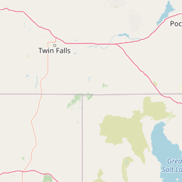
Map view of Curlew National Grassland

Use this park location map to pinpoint Curlew National Grassland in United States of America, understand its exact geographic position, and read its mapped placement within the surrounding landscape more clearly.

Pigeon | © OpenStreetMap contributors

Location context for Curlew National Grassland

Idaho
Recorded earthquake history

Review the Historical Earthquake Catalogue for Curlew National Grassland

Examine documented seismic activity near Curlew National Grassland through our curated earthquake catalogue. This resource aggregates data from regional monitors to provide a transparent look at recorded events, their magnitudes, and their proximity to this specific Idaho protected landscape.

Curlew National Grassland Earthquake History

Catalogued events

81 events

Strongest magnitude

Magnitude 6.1

Most recent event

May 28, 2026

This history includes earthquakes recorded inside the park or within 50 km of its borders

Visualizing the sagebrush steppe terrain and protected rangeland character of southeastern Idaho

Curlew National Grassland Photos and Landscape Scenery

Visual records capture the sweeping sagebrush steppe, rolling uplands, and semi-arid terrain that define the protected environment of Curlew National Grassland. Studying these field photographs reveals the subtle vegetative mosaic and wide-open topography of a restored Intermountain ecosystem.

A mule deer standing in tall grasses with snow-capped mountains in the distant background.

Park atlas

Compare regional protected areas and neighboring rangeland geography across southeastern Idaho

Exploring Parks Near Curlew National Grassland and Surrounding Protected Landscapes

Continue geographic discovery by browsing other protected areas and public lands located near Curlew National Grassland. Comparing adjacent sagebrush steppe and regional terrain helps place this restored grassland into a wider conservation context.
Watercolor painting of a calm lake surrounded by forested shores and distant mountains, depicted in soft pastel tones.
Protected landscapeIdaho
2.2 km away#1 closest

Northwest

Sawtooth National Forest: Geographic Overview and Protected Mountain Boundaries

Central Idaho mountain systems and wilderness corridors

Spanning over two million acres, Sawtooth National Forest defines the heart of the Rocky Mountains in Idaho. This protected landscape contains a complex network of glacial basins, alpine lakes, and varied ecosystems ranging from arid sagebrush foothills to high-altitude peaks. Explore the internal boundaries, drainage systems, and structural geography of this significant wilderness area.

Area
8,540.52 km²
Established
1905
Visitors
1.2M annual
Relief
Mountain
Wildlife reserveUtah
66 km away#2 closest

East

Mount Naomi Wilderness: Mapping High-Altitude Protected Landscapes in Northern Utah

Alpine summits, forested ridges, and subalpine lake basins

Situated in the Bear River Range of northern Utah, Mount Naomi Wilderness stands as a protected corridor of rugged mountain terrain. This wilderness area preserves a diverse high-elevation environment, spanning from the steep western canyons of the Logan River to the prominent summits of Naomi Peak. It serves as a vital point of geographic interest for understanding the subalpine ecosystems and wilderness boundaries within the Uinta-Wasatch-Cache National Forest.

Area
180.18 km²
Established
1984
IUCN
Ib
Relief
Mountain
Protected landscapeUnited States of America
About 69 km away#3 closest

Southeast

Wasatch-Cache National Forest Protected Area: Geography, Mountains, and Wilderness Mapping

Analyzing high-mountain terrain and watershed connectivity across the Intermountain West

Wasatch-Cache National Forest serves as a major ecological anchor in the United States. Its territory encompasses the iconic Wasatch Range, extensive designated wilderness zones, and alpine basins. The region provides critical watershed protection and supports diverse high-altitude ecosystems, from narrow, dissected ridges to broad, glaciated terrain throughout northern Utah and surrounding areas.

Area
6,504.01 km²
Established
1906
Relief
Mountain
Access
Easy access
Soft watercolor illustration of a rolling mountain landscape with a forested foreground and faded, distant peaks.
Protected landscapeIdaho
149 km away#4 closest

North

Salmon, Challis National Forest: Geography and Protected Land Map in Central Idaho

Extensive alpine ridges and wild river corridors

Spanning over 4.2 million acres, Salmon, Challis National Forest is a foundational protected landscape in Idaho. This area includes the highest peaks in the state, such as Borah Peak, and holds the majority of the Frank Church, River of No Return Wilderness. Utilize this atlas resource to examine the intricate mountain topography, expansive river systems, and the contiguous wild corridors that define this significant portion of the northern Rockies.

Area
17,142.2 km²
Established
1908
Relief
Mountain
Climate
Temperate
A pale watercolor painting showing a wide, panoramic view of layered mountains with light green and muted red hills in the foreground and clusters of pine trees.
Wildlife reserveUtah
About 171 km away#5 closest

Southeast

Mount Olympus Wilderness: Geographic Overview of the Iconic Wasatch Range Protected Landscape

Steep granite massif and alpine terrain in northern Utah

Explore the distinct topography of Mount Olympus Wilderness, a protected sanctuary in Utah featuring soaring granite outcrops and deep drainage systems. The park is anchored by a recognizable twin-peak silhouette that rises abruptly from the Salt Lake Valley, encompassing high alpine ridges and one of the deepest known cave systems in the United States within its rugged forested boundaries.

Access
Easy access
A watercolor painting showing soft green hills, distant pink-hued mountains, and a pale blue lake in a serene, stylized landscape.
Protected landscapeNevada
178 km away#6 closest

Southwest

Humboldt, Toiyabe National Forest: Protected Landscape and Regional Mountain Geography

A vast network of Nevada mountain ranges and alpine wilderness

Humboldt, Toiyabe National Forest serves as a defining public land entity across Nevada and eastern California. As the largest national forest in the contiguous United States, it preserves a striking collection of isolated mountain ranges, including the Ruby Mountains and the rugged Jarbidge wilderness, within a broader basin-and-range landscape. Examine the boundaries and terrain that characterize this complex, high-desert ecosystem.

Area
25,454 km²
Established
1908
Relief
Mountain
Access
Easy access
Wildlife reserveUtah
179 km away#7 closest

Southeast

Lone Peak Wilderness: Protected Alpine Geography and Wasatch Range Map Insights

Rugged glacial terrain and granite summits in Northern Utah

Lone Peak Wilderness represents a dramatic intersection of high-mountain wilderness and urban geography. Rising from the Salt Lake and Utah Valleys, its alpine terrain features jagged granite peaks, persistent snowfields, and steep glacial canyons. This protected landscape remains a critical reference for understanding the ecological and topographical character of the central Wasatch Range and Utah's wilderness preservation history.

Area
121.76 km²
Established
1978
IUCN
Ib
Relief
Mountain
Wildlife reserveWyoming
191 km away#8 closest

Northeast

Jedediah Smith Wilderness: Protected Alpine Terrain and Teton Range Geography

Glacially sculpted high-country basins in western Wyoming

Spanning the western face of the Teton Range, the Jedediah Smith Wilderness serves as a federally protected buffer for iconic mountain landscapes. The region features dramatic cirques, hanging valleys, and dense subalpine forest habitats, forming an essential, roadless link within the broader Greater Yellowstone Ecosystem. Explore the terrain features and structural geography that define this remote high-country wilderness area.

Area
499.59 km²
Established
1984
IUCN
Ib
Relief
Mountain

Common questions about visiting, size, designation, and location context for Curlew National Grassland

Curlew National Grassland FAQs for park facts, access, geography, and protected area context

Find quick answers about Curlew National Grassland, including protected-area facts, park geography, trail and visitor context, and how the park fits into its surrounding country and regional landscape.
MoriAtlas Explorer

Continue Your Protected Areas Search Across the Global Atlas

Deepen your exploration by continuing the structured search for national parks and protected areas worldwide. Utilize the comprehensive filtering capabilities to compare different conservation landscapes and refine your understanding of global park geography. Discover more about the distribution and characteristics of protected natural areas.

Global natural geography