
Mori Atlas logo
Nature reserveDammer Moor

Mapping the ecological diversity of protected wetlands, oak-hornbeam forests, and rare peat-forming habitats

Dammer Moor Nature Reserve: A Calcareous Valley Mire Landscape in Brandenburg, Germany

(Naturschutzgebiet und FFH-Gebiet Dammer Moor)

Dammer Moor is a protected nature reserve and Natura 2000 site situated in the Lieberose region of Brandenburg, Germany. This 181-hectare area centers on a rare calcareous watershed valley mire, supported by calcium-marl-rich hydrology that contrasts with surrounding acid bog landscapes. The mosaic of moist meadows, tall herb fringes, and varied woodland types, ranging from pedunculate oak forests to alder-ash riparian corridors, creates a significant hub for biodiversity in the eastern German lowlands.

moorvalley mireNatura 2000FFH sitenature reserveB randenburg
Vector illustration showing a scenic valley with a waterfall flowing between mountains, framed by stylized trees in the foreground.

Dammer Moor

Nature reserve

Park overview

Structured park overview, official facts, and landscape profile for Dammer Moor

Dammer Moor park facts, protected area profile, and essential visitor context

Review the core facts for Dammer Moor, including designation, size, terrain, visitor scale, habitats, and operating context in one park-focused overview.

About Dammer Moor

Dammer Moor occupies a position in the broader Lieberose landscape of Brandenburg where glacial history, low-lying topography, and base-rich groundwater interact to produce a distinctive wetland mosaic. As a both a German national nature reserve and a European FFH/Natura 2000 site, it receives layered protection and is managed under formal conservation objectives that emphasize the maintenance of water levels, the continuation of extensive grassland management, and the safeguarding of specific habitat types listed in Annex I of the Habitats Directive.

The reserve is administratively tied to the Landesumweltamt Brandenburg and managed under the Twenty-fourth Conservation Objectives Ordinance (24. ErhZV) of September 2018. Its conservation framework combines legal protection as a Naturschutzgebiet with the European Natura 2000 designation process, in which it was first proposed in February 1999 and confirmed in December 2004. Together, these designations create a long-term obligation to preserve rare habitat types and species rather than merely safeguard a generalized natural area.

Ecologically, Dammer Moor sits within a network of protected sites in Dahme-Spreewald district. Along with the adjacent Stockshof-Behlower Wiesen, Dobberburger Mühlenfließ, Lieberoser Endmoräne und Staakower Läuche, and Reicherskreuzer Heide und Schwanensee, it contributes to a Natura 2000 complex that spans around 28 kilometers east-west and 15 kilometers north-south. This regional clustering means that Dammer Moor is not an isolated reserve but a functional component of a wider conservation landscape shaped by end moraines, glacial valleys, and historical land use.

The combination of base-rich mire, wet meadows, ponds, oak woodland, and small fragments of moor and floodplain forest gives the site a layered ecological profile. It provides habitat for communities of amphibians and reptiles that depend on open water and moist grassland, for breeding wetland birds associated with disturbance-sensitive habitats, and for a wide flora of bog, meadow, and forest species that includes rare orchids and other plants of conservation concern.

Quick facts and research context for Dammer Moor

Dammer Moor is a nature reserve (Naturschutzgebiet) and coincident FFH / Natura 2000 site in the Lieberose area of Dahme-Spreewald district, Brandenburg, Germany. It covers approximately 180.73 hectares and was placed under national protection on 16 May 1990. The site was proposed as a Site of Community Importance in February 1999 and officially recognized as a Natura 2000 area in December 2004.

The territory lies west of the village of Goschen and is bordered by Doberburger Wald to the west, the Lieberoser Mühlenfließ stream, the L 434 to the north and the B 168 federal highway to the east. It encompasses a watershed valley mire with calcium mudde, wet meadows, ponds, oak woodland types, and fragments of moor and floodplain forest, and forms part of a broader Natura 2000 complex that also includes Stockshof-Behlower Wiesen, Dobberburger Mühlenfließ, Lieberoser Endmoräne und Staakower Läuche, and Reicherskreuzer Heide und Schwanensee.

Protection and recognition

Documented terrestrial boundary records, designation history, and Natura 2000 recognition.

Dammer Moor Protection Status and Official International Designations

Terrestrial protection status for Dammer Moor is established through official designation records dating from 2018. Natura 2000 data provides verified international recognition sources that outline the formal administrative scope for this protected landscape.

International recognition

Protection details

Protection scope
Terrestrial
Designated year
2018
Transboundary protection
No
WDPA ID
162699
Park context

Deeper park guide and search-rich context for Dammer Moor

Dammer Moor history, landscape, wildlife, and travel context

Explore Dammer Moor through its history, landscape character, ecosystems, wildlife, conservation priorities, cultural context, and seasonal travel timing in a structured park guide built for atlas discovery and search intent.

Why Dammer Moor stands out

Dammer Moor is especially known for its calcareous, watershed valley mire rich in calcium mudde (Kalkmudde), a comparatively rare peat-forming setting in Brandenburg. The reserve also stands out for its concentration of amphibian and reptile species, including European tree frog, moor frog, common toad, garlic toad, sand lizard, and grass snake. In addition, the site's mosaic of base-rich Molinion meadows, tall herb fringes, old acidic pedunculate oak forests, base-rich oak-hornbeam woodland, and small patches of moor and alder-ash floodplain forest gives it botanical significance. It hosts several rare and threatened orchids and other specialist wetland plants, supported by the lime-rich hydrology that distinguishes it from more typical acid bog landscapes of northern Germany.
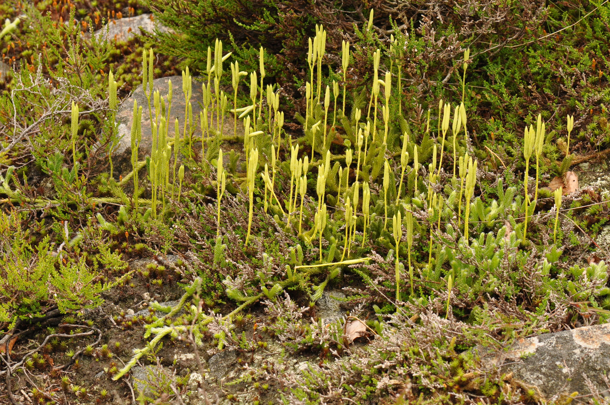
A close-up photograph of a cluster of bright green, stalk-like stag's-horn clubmoss plants emerging from low-lying moss and heath vegetation.
Stag's-horn clubmoss (Lycopodium clavatum) growing in the damp, mossy soil of Dammer Moor.

Dammer Moor history and protected-area timeline

Dammer Moor was placed under formal nature protection on 16 May 1990 through a national ordinance designating it as a Naturschutzgebiet. This step established its core protected status under German conservation law and laid the foundation for further international recognition.

In February 1999, the site was proposed as a Site of Community Importance under the European Union's Habitats Directive (Richtlinie 92/43/EWG, the so-called FFH Directive). The proposal was followed by formal acknowledgment as a Natura 2000 area in December 2004, giving the reserve an additional layer of European-level protection and binding management obligations aligned with the directive's habitat type and species targets.

The most recent major administrative framework is the Twenty-fourth Ordinance on Conservation Objectives and Area Boundaries for Sites of Community Importance (Vierundzwanzigste Erhaltungszielverordnung, 24. ErhZV) of 3 September 2018. This ordinance defines current conservation objectives, habitat targets, and required development measures, and it remains the principal management reference for the site. The reserve is administered by the Landesumweltamt Brandenburg, specifically its Ö2 department, which oversees implementation of Natura 2000 management plans and coordination of habitat restoration efforts such as the local Moorschutzprojekt Dammer Moor.

Dammer Moor landscape and geographic character

Dammer Moor occupies a low-lying position in the Lieberose area at elevations roughly between 46.2 and 55 meters above sea level. The local relief is gentle, but the site hides an important hydrological feature: a watershed within the mire, marked by the presence of calcium mudde (Kalkmudde), a base-rich peat substrate that distinguishes the valley from more typical acid bogs found elsewhere in northern Germany.

The wetter, lower parts of the reserve are dominated by moist grasslands and tall herb fringes, while slightly higher portions have historically been converted to cropland. In the eastern part of the area, a wooded block adds structural variety, and along the southern boundary sit three ponds connected to the wider hydrology through drainage ditches. Sediment and nutrient input from adjacent wet meadows have caused noticeable silting in these ponds over time.

The most distinctive pond, the Dammer Teich (Dammer Pond), was historically used for carp aquaculture. It was dammed on its southern edge and drained in a regulated manner into the Lieberoser Mühlenfließ, which runs along the western side of the reserve. To the west also lies the Doberburger Wald, a forest area adjoining the protected boundary. On the drier edges, the reserve supports base-rich oak-hornbeam woodland and old pedunculate oak forests on sandy substrate, segments of moor's edge forest, and small patches of alder-ash floodplain woodland along the brooks, producing a varied landscape mosaic unusual for a relatively compact reserve.

Dammer Moor ecosystems, habitats, and plant life

The ecological identity of Dammer Moor is shaped by the interaction of base-rich groundwater and a glacial lowland setting. At the center lies a calcareous valley mire on a watershed, with calcium marl deposits forming a distinctive peat type. Surrounding the mire core are wet meadows maintained through extensive use, tall herb communities along transitional moisture gradients, and ponds that intermix open water, reed margin, and silty bottom habitats.

The reserve encompasses several Annex I habitat types of European significance. These include Molinion caeruleae meadows on calcareous, peaty, or loamy-clayey substrate; tall herb fringes of the planar to montane level; calcareous fens; sub-Atlantic or central European pedunculate oak or stellate oak-hornbeam forests; old acidophilous pedunculate oak forests on sand plains; bog woodland; and alder-ash floodplain forests along watercourses. Together, these habitat types give the relatively small site a remarkable structural diversity.

Land cover proportions in the reserve, as recorded for its national designation, are dominated by mires, swamps, and riparian vegetation (approximately 36 percent) and deciduous forest (about 33 percent), with standing and flowing inland waters covering around 18 percent. Smaller shares include improved and ameliorated grassland, other arable land, coniferous and mixed forest, and a small strip of heath-like vegetation. This mixture underlines how Dammer Moor is at once a wetland reserve and a woodland reserve, with the balance of habitats maintained both by natural hydrology and by human land use practices that include extensive meadow management and ecologically sensitive forest treatment.

Dammer Moor wildlife and species highlights

Dammer Moor is especially notable for its rich amphibian and reptile fauna. The ponds, ditches, and wet meadows provide breeding habitat for the European tree frog, moor frog, pool frog, common toad, and garlic toad, while the dry edges and warmer clearings are used by sand lizard and grass snake. The combination of open water, moist grassland, and surrounding woodland edges supports this unusually dense herpetological community for a compact Brandenburg reserve.

Also associated with the moor's open water and adjacent meadows are fire-bellied toads (Rotbauchunke) and northern crested newts, both listed in Annex II of the FFH Directive. Aquatic habitats also nurture the water frog and a number of fish, while historical carp aquaculture in the Dammer Teich demonstrates past management relationships with the site's ponds. Dragonflies are represented in part by the green hawker (Grüne Mosaikjungfer), a species tied to specific standing water habitats.

The reserve has strong ornithological value. White-tailed eagle, black stork, and osprey may move through the broader landscape, while wetland-dependent species such as common crane, Eurasian bittern, hen harrier, marsh harrier, common kingfisher, black woodpecker, Eurasian hobby, red-backed shrike, and whooper swan have all been recorded or considered relevant to the area. Surrounding woodland and ponds also host common waterfowl such as gadwall, garganey, northern shoveler, Eurasian teal, Eurasian wigeon, tufted duck, common pochard, and goldeneye, along with wetland songbirds including Savi's warbler and the river warbler.

Mammal records include the Eurasian otter along watercourses, while the wider landscape is known to support threatened bat species such as the barbastelle, greater mouse-eared bat, common noctule, common pipistrelle, Nathusius's pipistrelle, grey long-eared bat, brown long-eared bat, Natterer's bat, Brandt's bat, and lesser noctule. The butterfly fauna includes species such as the large copper (Lycaena dispar), a butterfly of Annex II importance, alongside other notable lowland-moisture specialists.

Dammer Moor conservation status and protection priorities

Dammer Moor carries a dual conservation status. At national level, it is a designated Naturschutzgebiet established in May 1990 and given the identification number 1263. At European level, it is part of the Natura 2000 network as an FFH site, a designation that followed its February 1999 proposal as a Site of Community Importance and its December 2004 recognition.

Conservation objectives for the site focus on maintaining the existing extent of moor and bog woodland as well as old oak forests while stabilizing the water balance across the catchment. Key management actions include raising water levels to prevent drying, securing suitable water depths in drainage ditches as part of the local Moorschutzprojekt Dammer Moor, blocking or restructuring redundant ditches without filling them entirely to create new small water bodies, restoring open habitats through extensive pond management, sustaining traditional extensive use of wet meadows and tall herb fringes, and adding deadwood and preserving biotope trees in adjacent forests.

The reserve forms one node in a larger Natura 2000 cluster for the Lieberose region, alongside Stockshof-Behlower Wiesen, Dobberburger Mühlenfließ, Lieberoser Endmoräne und Staakower Läuche, and Reicherskreuzer Heide und Schwanensee. This regional connectivity strengthens the conservation value of Dammer Moor, as species requiring both wetland and forest or open mosaic habitats can move between protected areas. Management is overseen by the Landesumweltamt Brandenburg under the 24th Conservation Objectives Ordinance of September 2018, with the reserve recognized as IUCN Category IV: a Habitat/Species Management Area.

Dammer Moor cultural meaning and human context

The area around Dammer Moor has been shaped by long-term human interaction with wet landscapes. The presence of managed wet meadows, historically cultivated fish ponds such as the Dammer Teich, and a network of drainage ditches reflects centuries of practical adaptation to base-rich, low-lying terrain in the Lieberose region. The Lieberoser Mühlenfließ, a historical mill brook running along the western edge, underlines the role of watermills and stream management in shaping the local settlement pattern.

Villages such as Goschen, Schadow, and Doberburg, now parts of the town of Lieberose, frame the reserve geographically. Their relationship with the surrounding woodlands, meadows, and ponds has helped maintain the open habitats that today form the basis of conservation management. The combination of agricultural legacy and ecological protection gives the reserve a landscape identity that is both cultural and ecological, rooted in the long coexistence of human land use and wetland habitats in eastern Brandenburg.

Top sights and standout views in Dammer Moor

Dammer Moor combines the protection profile of a German national nature reserve with that of a European FFH/Natura 2000 site, giving it unusually strong legal backing. Its defining feature is a calcareous watershed valley mire on calcium mudde, a comparatively rare peat-forming environment for Brandenburg and northern Germany as a whole.

The reserve's habitat diversity is unusually broad for its size, encompassing wet meadows, Molinion grasslands, tall herb fringes, calcareous fen, oak-hornbeam woodland, old pedunculate oak forest, moor woodland, and alder-ash floodplain forest, all linked by a network of ponds and ditches. Its amphibian and reptile density stands out, while its breeding and migratory bird fauna includes white-tailed eagle, black stork, common crane, bittern, and hen harrier among other wetland-dependent species.

Best time to visit Dammer Moor

Because the reserve's core interest lies in its wetland habitats, amphibian populations, and breeding birds, the most informative months for observing its ecological character are spring and early summer, when amphibian breeding activity peaks in the ponds and ditches and when many migratory and breeding wetland birds are present. Late spring also brings the most active flowering period for the reserve's orchid-rich meadows and tall herb fringes.

In summer, the open waters, fringes, and surrounding woodland give a fuller picture of the site's full habitat mosaic, including dragonflies, butterflies such as the large copper, and the bird community of water, meadow, and woodland edges. Autumn and winter visits, while quieter, may offer opportunities to observe waterfowl concentrations on ponds and to appreciate the broader landscape character of the Lieberose countryside. As with any protected area, practical access may be limited, and any visit should focus on the publicly accessible surroundings rather than the reserve's sensitive core.

Monthly climate preview

Long term representative weather by month and annual thermal progression for Dammer Moor

Dammer Moor Climate Normals, Average Temperature and Precipitation Patterns

Historical measurements from 1991 to 2020 outline the measured temperature ranges and daily precipitation averages across representative coordinates in Brandenburg. Detailed monthly breakdowns provide deeper insight into long term climate trends and annual weather variations across the protected landscape.
Annual mean9 °C
-1 °C21 °C
Jan-1°
Feb
Mar
Apr
May14°
Jun18°
Jul21°
Aug20°
Sep15°
Oct
Nov
Dec
Warmest month
July

20.5 °C

Coolest month
January

-1 °C

Wettest month
July

2.6 mm/day

Driest month
April

1.1 mm/day

Park location guide

Geography guide, regional context, and park location map for Dammer Moor

Dammer Moor park geography, regions, and map view in Germany

Understand where Dammer Moor sits in Germany through a broader geographic reading of the surrounding landscape, nearby location context, and its mapped position within the national park landscape.

How Dammer Moor fits into Germany

Germany is a federal republic in Western and Central Europe with a population of over 83 million across sixteen constituent states. It is Europe's largest economy by nominal GDP and a major global exporter and importer. The capital is Berlin, and the country borders Denmark, Poland, Czech Republic, Austria, Switzerland, France, Luxembourg, Belgium, and the Netherlands.

Wider geography shaping Dammer Moor in Germany

Germany is located in Western and Central Europe, spanning 357,022 km². It borders Denmark to the north, Poland and the Czech Republic to the east, Austria and Switzerland to the south, and France, Luxembourg, Belgium, and the Netherlands to the west. The country has coastlines on the Baltic Sea and North Sea to the north, with the Alps located in the southern region.

Map view of Dammer Moor

Use this park location map to pinpoint Dammer Moor in Germany, understand its exact geographic position, and read its mapped placement within the surrounding landscape more clearly.

Pigeon | © OpenStreetMap contributors

Location context for Dammer Moor

Brandenburg

Explore the scenery, habitats, and watershed terrain of Brandenburg

Dammer Moor Photos and Landscapes: Visual Guide to the Protected Valley Mire

Visual documentation reveals the calcareous valley mire, wet meadows, and oak woodlands that define the protected environment of Dammer Moor. Examining these detailed landscape photographs provides deeper insight into the rare wetland habitats and terrain of the region.

A close-up photograph of a cluster of bright green, stalk-like stag's-horn clubmoss plants emerging from low-lying moss and heath vegetation.

A wide-angle, eye-level shot of a flat, green meadow or marshy field under a clear blue sky, with a dense forest line in the background.

Park atlas

Compare regional protected areas and connected conservation terrain across Brandenburg.

Exploring Parks Near Dammer Moor and Surrounding Protected Wetland Landscapes

Browsing other parks near Dammer Moor reveals broader wetland clusters and connected protected landscapes throughout the Lieberose region. Comparing these regional reserves highlights similar valley mires and diverse forest ecosystems across eastern Germany.
A watercolor painting showing a panoramic view of the Spree River mouth with green trees, reeds, and marshy water areas.
Nature reserveBrandenburg
6.4 km away#1 closest

Northwest

Alte Spreemündung Nature Reserve: Protected Wetland and River Geography in Brandenburg

A preserved mosaic of river mouths and lake shorelines

Alte Spreemündung serves as a focal point for understanding the transition between the River Spree and the Schwielochsee in Brandenburg. This protected area covers a compact, water-shaped terrain characterized by riparian habitats and ancient river arms. It remains a key site for examining the glacial geomorphology and lowland water dynamics prevalent across northeastern Germany.

Area
1.08 km²
Established
1990
IUCN
IV
Nature reserveBrandenburg
About 6.7 km away#2 closest

North

Dammühlenfließniederung Nature Reserve: Brandenburg Protected Land and Geography Atlas

Floodplain and riparian habitats in the Niederlausitz region

Explore the geographic framework of Dammühlenfließniederung, an essential nature reserve in eastern Brandenburg. This area safeguards the Dammühlenfließ stream valley and a segment of the Schwielochsee lakeshore, representing the unique glacial lowlands of the region through a focused wetland and floodplain corridor.

Area
0.79 km²
Established
1998
IUCN
IV
A soft watercolor painting of a wetland featuring grassy foregrounds, a winding stream, distant rolling hills, and a pale sky.
Protected areaBrandenburg
About 22 km away#3 closest

Northwest

Reichardtsluch Protected Area: A Wetland Geography Overview in Brandenburg, Germany

Glacial moraine terrain and seasonal amphibian habitats

Reichardtsluch acts as a vital, two-hectare wetland refuge within the Beeskower Platte region of Brandenburg. This protected landscape is defined by its dramatic seasonal hydrology, alternating between full inundation and dry spells. The site remains a core component of the broader Natura 2000 network, offering insight into postglacial drainage patterns and forest-fringed amphibian breeding ecology in eastern Germany.

Area
0.29 km²
Established
2003
Relief
Lowland
Climate
Temperate
Nature reserveBrandenburg
23 km away#4 closest

West

Feuchtwiesen Atterwasch Nature Reserve: Brandenburg Protected Wetland Geography

Mapped floodplain habitats along the Schwarze Fließ stream

Feuchtwiesen Atterwasch represents a vital protected landscape in eastern Germany, defined by its intricate mosaic of wet meadows, ditches, and alluvial forests. As an officially recognized nature reserve and Natura 2000 site, it anchors a unique lowland ecological corridor in Brandenburg, supporting rare floodplain vegetation and essential habitats for protected wetland species across the Gubener Land region.

Area
1.93 km²
Established
2004
IUCN
IV
Relief
Lowland
A pale, soft-toned watercolor painting showing a wetlands landscape with rolling green hills, a calm river or stream, and sparse red vegetation in the foreground.
Nature reserveBrandenburg
About 24 km away#5 closest

West

Kockot Nature Reserve: Protected Hardwood Forest and Brandenburg Hydrology

A core zone of the Spreewald Biosphere Reserve

Kockot represents an essential piece of Brandenburg lowland geography. This nature reserve protects a water-influenced hardwood forest mosaic on peat and gley soils, offering a focused look at non-intervention forest dynamics within the Spree river floodplain system.

Area
2.868 km²
Established
1990
IUCN
IV
Nature reserveBrandenburg
24 km away#6 closest

West

Wiesenau Nature Reserve: Mapped Habitat Mosaic and Protected Landscapes in Brandenburg

Essential geographic overview of the Spreewald floodplain ecosystems.

Located near Lübben, Wiesenau protects a rich array of ponds, oxbows, and sediment zones integrated into the Spreewald Biosphere Reserve. The area serves as a prime example of the diverse, interconnected woodland and wetland terrain characteristic of the Brandenburg lowland region.

Area
1.35 km²
Established
1990
IUCN
IV
Nature reserveBrandenburg
28 km away#7 closest

West

Meiereisee und Kriegbuschwiesen: A Protected Mosaic of Mires, Dunes, and Floodplain Meadows

Geographic analysis of a specialized Brandenburg nature reserve

The Meiereisee und Kriegbuschwiesen nature reserve is defined by its complex geological and ecological layout, spanning four separate zones that range from dystrophic lakes and kettle bogs to dry sand dunes and low-intensity hay meadows. This protected entity provides a critical refuge for wetland species within the larger Spreewald Biosphere Reserve area of Brandenburg.

Area
1.172 km²
Established
2000
Relief
Lowland
Climate
Temperate
Nature reserveBrandenburg
29 km away#8 closest

South

Koselmühlenfließ Nature Reserve: A Protected Stream Valley in the Brandenburg Region

Geographic overview of the Lusatian land ridge brook habitat

Koselmühlenfließ protects a largely natural lowland stream and its floodplain corridor set amidst the undulating landscapes of the Lusatian land ridge. This nature reserve in the Spree-Neisse district represents a focused contribution to the Brandenburg conservation network, highlighting the value of small-scale brook environments in northeast Germany.

Area
1.12 km²
Established
2006
IUCN
IV
Relief
Lowland

Common questions about visiting, size, designation, and location context for Dammer Moor

Dammer Moor FAQs for park facts, access, geography, and protected area context

Find quick answers about Dammer Moor, including protected-area facts, park geography, trail and visitor context, and how the park fits into its surrounding country and regional landscape.
MoriAtlas Explorer

Continue Your Protected Areas Search Across the Global Atlas

Deepen your exploration by continuing the structured search for national parks and protected areas worldwide. Utilize the comprehensive filtering capabilities to compare different conservation landscapes and refine your understanding of global park geography. Discover more about the distribution and characteristics of protected natural areas.

Global natural geography