
Mori Atlas logo
Nature reserveDolina Wkry Nature Reserve

A critical study of breakthrough river valley topography and rare floodplain forest ecosystems

Dolina Wkry Nature Reserve: Investigating the Protected Gorge and Riverine Landscapes of Poland

(Rezerwat przyrody Dolina Wkry)

Dolina Wkry Nature Reserve serves as a vital protected landscape, preserving a distinctive gorge-like reach of the Wkra River in the Masovian Voivodeship. This geographic enclave features rare remnants of riparian alder forests, offering a preserved window into the natural river dynamics that once defined the broader lowland surroundings of the Ciechanów Upland. The site documents a complex layering of river terraces, steep valley walls, and saturated floodplain soils that remain protected from agricultural expansion.

river valleyriparian forestfloodplain forestalder woodlandbirch and pine forestriver gorge
A flat-style digital illustration showing a valley framed by evergreen trees in the foreground, with steep cliffs, a waterfall, and a river flowing through the center under a sunny sky.

Dolina Wkry Nature Reserve

Nature reserve

Park overview

Structured park overview, official facts, and landscape profile for Dolina Wkry Nature Reserve

Dolina Wkry Nature Reserve park facts, protected area profile, and essential visitor context

Review the core facts for Dolina Wkry Nature Reserve, including designation, size, terrain, visitor scale, habitats, and operating context in one park-focused overview.

About Dolina Wkry Nature Reserve

Dolina Wkry Nature Reserve is a compact but ecologically focused protected area situated in north-central Poland, in the Mazovian Voivodeship, within the administrative boundaries of Gmina Pomiechówek. It lies near the small villages of Szczypiorno, Kosewko, and Goławice Drugie, where the Wkra River, a known tributary of the Narew, passes through a geologically older, slightly higher piece of terrain. This short section is locally described as a breakthrough or gorge-like reach, and it is unusual within the broader lowland setting of the Ciechanów Upland (Wysoczyzna Ciechanowska), where most river valleys are wide and shallow rather than incised.

The reserve's purpose, as formally stated at its founding in 1991, is the preservation of both the breakthrough river-landscape scenery and the surviving patches of floodplain forest along the Wkra. These riparian forests form a narrow but ecologically valuable ribbon of habitat along the watercourse, depending on the natural hydrological fluctuations of the river. In much of the surrounding agricultural and suburban landscape, similar forests have been cleared, drained, or replaced by planted stands, so the reserve takes on added importance as a reference site for what historical Wkra valley vegetation looked like.

The area is administered within the Pomiechówek forest district, one of several districts that make up the Jabłonna forest inspectorate region. This means that the reserve is embedded in a working state forest landscape, where managed timber stands surround strictly protected core areas. Active protection measures are applied to maintain the open and semi-open character of the valley and the integrity of the river-forest ecotone. Although the reserve is smaller than many well-known Polish national parks, its value lies in the combination of geology, river dynamics, and woodland composition that it preserves in such a tightly defined space.

Quick facts and research context for Dolina Wkry Nature Reserve

Dolina Wkry is a Polish landscape nature reserve located in the Mazovian Voivodeship, within Gmina Pomiechówek, in the Wysoczyzna Ciechanowska mesoregion. It was established in 1991 by ministerial ordinance to protect a breakthrough section of the Wkra River along with surviving fragments of riparian forest.

The reserve covers roughly 24 hectares of forest and river valley within the Pomiechówek forest district, which itself belongs to the Jabłonna forest inspectorate. Active protection management is applied to maintain the landscape and ecological character of the protected area.

Protection and recognition

Review documented terrestrial protection scope and international recognition sources.

Dolina Wkry Nature Reserve Protection Status and Recognition Records

Dolina Wkry Nature Reserve holds recorded terrestrial protection parameters for conservation evaluation. Structured records outline baseline governance and formal recognition data.

Protection details

Protection scope
Terrestrial
Transboundary protection
No
Park context

Deeper park guide and search-rich context for Dolina Wkry Nature Reserve

Dolina Wkry Nature Reserve history, landscape, wildlife, and travel context

Explore Dolina Wkry Nature Reserve through its history, landscape character, ecosystems, wildlife, conservation priorities, cultural context, and seasonal travel timing in a structured park guide built for atlas discovery and search intent.

Why Dolina Wkry Nature Reserve stands out

The reserve is best known for protecting a short, geomorphologically distinctive reach of the Wkra River where the watercourse cuts through upland terrain, producing a gorge-like valley cross-section that contrasts with the typically flat surroundings of the Mazovian lowlands. Equally important is the reserve's role in conserving what's left of the natural floodplain forests that once lined the Wkra. These riparian woodlands are dominated by common alder along the wettest zones, with birch and Scots pine occupying drier transitional surfaces, and together they represent a habitat pattern that has become rare in intensively used agricultural and urban landscapes.
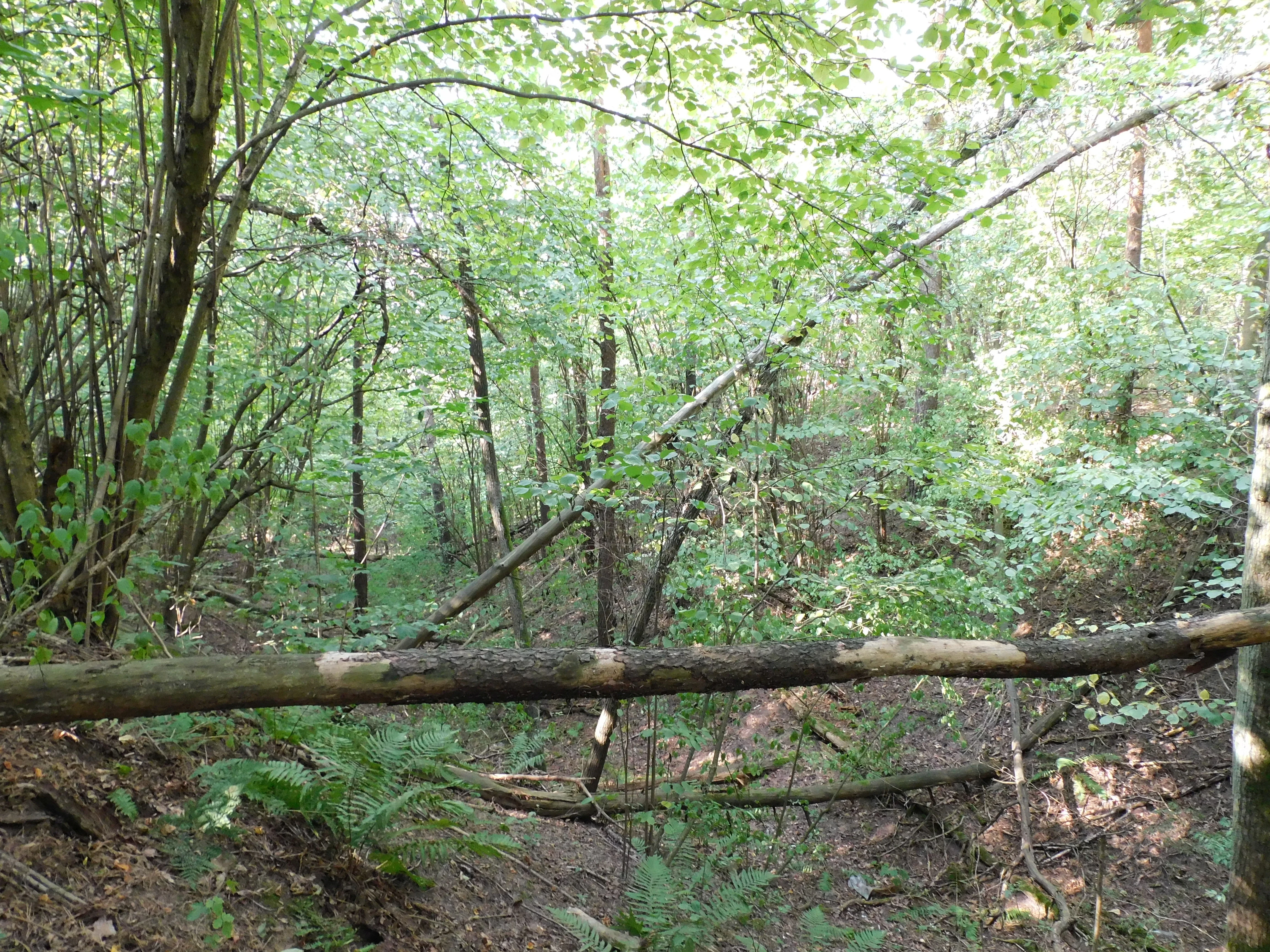
A dense green forest scene featuring a wooden guardrail in the foreground and a ravine with fallen trees in the background.
A view into the wooded ravine at the Dolina Wkry Nature Reserve.

Dolina Wkry Nature Reserve history and protected-area timeline

Dolina Wkry Nature Reserve was officially created on 8 July 1991 through a formal ordinance published in the Polish Monitor. The founding instrument defined the reserve as a landscape-type nature reserve, a category designed to protect scenery and landform combinations as much as biological communities.

The reserve was established on land belonging to state forests, within the Pomiechówek district of the Jabłonna forest inspectorate, and on the territory of three local villages: Szczypiorno, Kosewko, and Goławice Drugie. The original legal designation of the area at the time of creation was slightly smaller than its measured contemporary footprint, reflecting natural change within the river valley or refinements to the protected boundary.

From the outset, active protection was applied to the reserve, meaning that management interventions are used to maintain its characteristic landscape features rather than relying purely on passive, hands-off protection. The reserve thus represents an early example of the active, conservation-oriented management of small lowland river landscapes in post-1990s Poland, when many such sites were being formally designated to shield them from expanding agricultural and suburban pressure in the Warsaw region.

Dolina Wkry Nature Reserve landscape and geographic character

The landscape of Dolina Wkry is defined primarily by the Wkra River, which here crosses a slightly elevated, older land surface and produces an incised or breakthrough valley relative to the gentler lowlands upstream and downstream. This gorge-like character is the single most distinctive physical feature of the reserve and the reason the area was given landscape-type protected status.

The valley walls and slopes drop toward a narrow floodplain, with the river channel itself forming the core of the protected complex. Around and above the channel, the relief transitions from steep valley edges to the more typical gentle slopes of the Ciechanów Upland, a regional geographic unit (mezoregion) characterized by post-glacial plain surfaces interrupted by shallow river valleys.

The visual impression of the reserve is therefore one of a compact wooded valley carved into otherwise flat surroundings. River terraces, saturated floodplain flats, and drier plateau edges all occur within a small radius, producing rapid transitions between habitats and a layered topographic structure that gives the reserve a sense of depth and enclosure unusual for such a small Polish protected area.

Dolina Wkry Nature Reserve ecosystems, habitats, and plant life

Ecologically, the reserve preserves a representative fragment of the riparian forest complex that once accompanied the Wkra through its middle course. The forests are dominated by common alder in the lowest, most frequently flooded parts of the valley, where the water table rises with the river and the soil remains permanently moist. This alder-dominated community represents one of the classic floodplain forest types of the Polish lowlands.

On slightly higher and better-drained surfaces above the active floodplain, the tree cover shifts to woods dominated by birch, with common Scots pine occupying the driest and sandiest positions along valley edges and slopes. This layering from wet alder stands, through mixed birch woodland, to pine-dominated drier forest, mirrors the natural moisture gradient of the river valley and gives the reserve a clear internal habitat zonation.

Together, these communities form a small but unusually complete example of a lowland river valley forest sequence. The combination of river dynamics, distinct topography, and varied woodland patches makes the reserve valuable for understanding how natural vegetation responded to subtle elevation and moisture differences along the Wkra before extensive landscape transformation in the region.

Dolina Wkry Nature Reserve wildlife and species highlights

As a small, forest-dominated river reserve, Dolina Wkry supports a typical set of lowland riparian and woodland species rather than spectacular large fauna. The river corridor and adjacent alder-birch-pine stands provide habitat for common Polish forest and water-associated birds, small mammals, and a typical assemblage of amphibians and invertebrates tied to moist woodland and slow-moving water.

The floodplain forest mosaic offers cover and food resources for generalist woodland species that thrive in mixed-age deciduous and coniferous stands, while the river itself and its banks provide habitat for freshwater fauna typical of lowland Polish rivers in the Narew catchment system. Because the reserve is small and embedded in a much larger managed forest district, it functions primarily as a protected core within a working forest landscape rather than a standalone wilderness refuge for rare species.

Dolina Wkry Nature Reserve conservation status and protection priorities

The conservation significance of Dolina Wkry lies less in uniqueness of individual species and more in the integrity of a small, representative lowland river gorge-forest system. By formally protecting both the breakthrough landscape of the Wkra and the remaining floodplain forest fragments, the reserve maintains an example of a habitat combination that has been heavily reduced across the surrounding region.

Dolina Wkry Nature Reserve cultural meaning and human context

The reserve sits within an area of long-established rural settlement, framed by the small villages of Szczypiorno, Kosewko, and Goławice Drugie. These are traditional Mazovian villages whose relationship with the Wkra River has historically combined farming, fishing, and forest use, with the river valley serving both as a local landmark and as a source of natural resources.

Top sights and standout views in Dolina Wkry Nature Reserve

Dolina Wkry stands out for its compact but unusually well-defined combination of a breakthrough river landscape and preserved floodplain forest, a pairing that has become increasingly rare in the intensively used Mazovian lowlands.

Its values are practical and concrete: a clearly defined protected river reach, intact alder-dominated riparian forest, and a layering of habitats from river edge to dry valley slopes, all protected within an active management framework that integrates the reserve into the surrounding state forest landscape.

Best time to visit Dolina Wkry Nature Reserve

The reserve is essentially a woodland and river environment, so the experience of visiting varies mainly with the seasons typical of central Poland. Late spring and early summer bring the freshest foliage and the most active birdlife in the riparian forest, while autumn turns the birch and alder woodland into a vivid display of yellow and gold against the darker pine cover on the valley slopes.

Winter offers a quieter, more open view of the valley structure itself, when the leafless deciduous trees reveal the gorge-like profile of the Wkra that is otherwise hidden beneath dense summer canopy. River levels and accessibility can vary with seasonal precipitation and snowmelt, so drier periods generally make walking and viewing easier.

Monthly climate preview

Measured long term averages for temperature and monthly precipitation patterns

Dolina Wkry Nature Reserve Climate Normals and Annual Temperature Rhythm

Representative coordinate sampling records the annual temperature progression and precipitation rhythm across Dolina Wkry Nature Reserve from 1991 to 2020. Access the complete twelve month profile to examine detailed monthly averages and long term climate normals.
Annual mean8 °C
-4 °C20 °C
Jan-4°
Feb-2°
Mar
Apr
May14°
Jun18°
Jul20°
Aug19°
Sep14°
Oct
Nov
Dec-2°
Warmest month
July

19.9 °C

Coolest month
January

-3.7 °C

Wettest month
July

2.5 mm/day

Driest month
March

1.2 mm/day

Park location guide

Geography guide, regional context, and park location map for Dolina Wkry Nature Reserve

Dolina Wkry Nature Reserve park geography, regions, and map view in Poland

Understand where Dolina Wkry Nature Reserve sits in Poland through a broader geographic reading of the surrounding landscape, nearby location context, and its mapped position within the national park landscape.

How Dolina Wkry Nature Reserve fits into Poland

Poland, officially the Republic of Poland, is a Central European country spanning from the Baltic Sea in the north to the Carpathian Mountains in the south. It borders Germany, Czech Republic, Slovakia, Ukraine, Belarus, Lithuania, and Kaliningrad Oblast. The country has a temperate climate, diverse landscapes, and is known for its rich history, cultural heritage, and strong economic position within the EU.

Wider geography shaping Dolina Wkry Nature Reserve in Poland

Poland occupies 312,696 km2 in Central Europe, extending from the Baltic Sea coast in the north to the Sudetes and Carpathian Mountains in the south. It borders Germany to the west, Czech Republic and Slovakia to the south, Ukraine and Belarus to the east, and Lithuania and Kaliningrad Oblast to the northeast. The landscape includes lowland plains, uplands, and mountain ranges.

Map view of Dolina Wkry Nature Reserve

Use this park location map to pinpoint Dolina Wkry Nature Reserve in Poland, understand its exact geographic position, and read its mapped placement within the surrounding landscape more clearly.

Pigeon | © OpenStreetMap contributors

Location context for Dolina Wkry Nature Reserve

Masovian Voivodeship

Visualizing the river gorge, riparian woodlands, and protected lowland terrain

Dolina Wkry Nature Reserve Photos and Landscape Scenery

Visual records capture the distinctive gorge-like valley and surviving floodplain forests that define the protected river reach. Exploring these environmental images helps observers understand the regional topography, alder woodland habitats, and varied terrain structure of the protected area more thoroughly.

A dense green forest scene featuring a wooden guardrail in the foreground and a ravine with fallen trees in the background.

Park atlas

Compare surrounding regional geography and connected lowland river valleys

Other Parks and Protected Areas Near Dolina Wkry Nature Reserve

Browse nearby protected landscapes and river valley reserves following a visit to Dolina Wkry Nature Reserve. Comparing adjacent lowland habitats and terrain features expands regional geographic discovery.
National parkMasovian Voivodeship
About 7.8 km away#1 closest

South

Kampinos National Park: Geographic Profile and Protected Forest Landscape Map

Inland dune formations and wetland habitats in Masovian Voivodeship

The expansive woodland of Kampinos National Park represents a critical protected area in Poland, characterized by its parabolic sand dunes and low-lying marshes. Gain insights into the geomorphological features of this UNESCO biosphere reserve and trace the complex hydrological network that defines its unique forest environment.

Area
385.44 km²
Established
1959
IUCN
II
Relief
Lowland
A soft watercolor illustration of a marshy landscape with low rolling hills, scattered trees, and a winding stream, rendered in light green and yellow tones on a white background.
National parkMasovian Voivodeship
About 7.8 km away#2 closest

Southwest

Kampinoski Park Narodowy: Mapping the Inland Dune and Wetland Landscapes of Central Poland

A vital protected area in Masovian Voivodeship

The landscape of Kampinoski Park Narodowy is defined by the Grochalskie Piachy dune complex and diverse riparian habitats. This atlas entry covers the geological history and protected boundaries of this significant lowland forest, tracing the Vistula river valley's influence on the surrounding terrain and ecological character.

Area
385.443 km²
Established
1959
Visitors
1M annual
Relief
Lowland
A pale, soft-focus watercolor illustration showing a horizontal landscape of rolling green hills, distant hills in shades of purple and grey, and groups of conifer trees.
Protected landscapeMasovian Voivodeship
About 29 km away#3 closest

East

Puszcza Biała Protected Landscape: Map and Geography of the Mazovian Lowland Forests

Extensive pine-dominated woodlands of Masovian Voivodeship

Puszcza Biała is a massive, continuous lowland forest in east-central Poland, characterized by its dominant Scots pine stands and post-glacial sandy soils. Positioned between the Bug and Narew rivers, this protected landscape provides a quiet, expansive green space that serves as an essential component of the regional natural geography of the Masovian Voivodeship.

Area
850 km²
Relief
Lowland
Scope
Terrestrial
Water
Major water bodies
A soft watercolor illustration of a winding river flowing through a green valley with forested hills in the background.
Nature reserveMazowieckie
About 45 km away#4 closest

Southeast

Rezerwat przyrody Morysin: Protected Floodplain Landscapes and Historic Forest Reserves

A riparian heritage site in the Mazowieckie region

Situated in the Vistula floodplain, Rezerwat przyrody Morysin stands as a significant protected area defined by its massive old-growth trees and layered cultural history. The terrain incorporates diverse wetland features, including the Sobieski Canal and Wilanówka stream, creating a vital habitat for cavity-nesting species and a rare example of integrated natural and historic preservation.

Area
0.535 km²
Established
1996
Relief
Lowland
Climate
Temperate
A wide watercolor illustration showing a river flowing through a grassy landscape with a line of trees in the background, rendered in soft greens, pinks, and purples.
Nature reserveMazovian Voivodeship
About 48 km away#5 closest

East

Rezerwat przyrody Dębina Nature Reserve: Exploring Protected Landscapes in Mazovian Voivodeship

A preserved oak-hornbeam forest featuring glacial erratics and ancient woodland

Rezerwat przyrody Dębina is a significant nature reserve situated in the Mazovian Voivodeship, noted for its 200-year-old oak stands and multi-species deciduous canopy. As the oldest protected area in the region, it preserves a vital remnant of the Polish Lowlands landscape, offering a dense, ecologically rich forest environment defined by subtle topography and unique Pleistocene glacial boulders.

Area
0.512 km²
Established
1952
Relief
Lowland
Climate
Temperate
Nature reserveMasovian Voivodeship
About 52 km away#6 closest

South

Rezerwat przyrody Młochowski Grąd: Protected Forest Geography and Nature Reserve Map

Mapping lowland woodland communities in Masovian Voivodeship

Rezerwat przyrody Młochowski Grąd preserves a representative fragment of natural oak and pine forest within the flat plains of central Poland. Discover the ecological layout of this protected area, including its grąd deciduous communities and its role as a reference site for forest research in the Masovian Voivodeship landscape.

Area
0.27 km²
Established
1983
Relief
Lowland
Climate
Temperate
Watercolor painting of a meandering river landscape with gentle hills, light green foliage in the foreground, and soft washes of color.
Protected landscapeLodz Voivodeship
About 52 km away#7 closest

Southwest

Bolimowski Park Krajobrazowy: Geography of a Central Polish Protected Landscape Area

Rawka River valley mapping and Puszcza Bolimowska forest terrain

Bolimowski Park Krajobrazowy encompasses a unique mosaic of postglacial plains and riverine ecosystems in central Poland. The area is defined by the Rawka River, which forms a network of meanders, oxbow lakes, and terraces, while surrounding forests retain historical links to the vast primeval woods of Puszcza Bolimowska. This protected territory offers a significant habitat for diverse wildlife, including moose and beaver, within a landscape characterized by its shifting transition between deep forest, wet meadows, and light oak groves.

Area
205.123 km²
Established
1986
Relief
Lowland
Climate
Temperate
A flat vector illustration of a grassy meadow with yellow dandelions, a winding dirt path lined with fence posts, a forest in the midground, and large mountains in the background under a sky with pink clouds.
Protected areaMazovia Voivodeship
About 53 km away#8 closest

Northeast

Bagno Pulwy: A Geographic Overview of the Mazovian Wetland and Peatland Mosaic

Protected marshland landscapes and Narew valley terrain

Bagno Pulwy represents an extensive lowland wetland in Poland's Mazovia region, characterized by its wide meadows, peat-rich soil, and intricate network of historical drainage canals. This protected area offers a distinct geographic contrast to the surrounding forested uplands, functioning as a vital open habitat situated within the broader Narew river valley drainage system.

Area
60 km²
Water
Major water bodies

Common questions about visiting, size, designation, and location context for Dolina Wkry Nature Reserve

Dolina Wkry Nature Reserve FAQs for park facts, access, geography, and protected area context

Find quick answers about Dolina Wkry Nature Reserve, including protected-area facts, park geography, trail and visitor context, and how the park fits into its surrounding country and regional landscape.
MoriAtlas Explorer

Continue Your Protected Areas Search Across the Global Atlas

Deepen your exploration by continuing the structured search for national parks and protected areas worldwide. Utilize the comprehensive filtering capabilities to compare different conservation landscapes and refine your understanding of global park geography. Discover more about the distribution and characteristics of protected natural areas.

Global natural geography