Mori Atlas logo
National parkKampinos National Park

Examining the ancient inland dune systems and wetland ecosystems of a Polish forest reserve

Kampinos National Park: Mapped Protected Landscapes and Geographic Terrain in Masovian Voivodeship

(Kampinoski Park Narodowy)

Kampinos National Park stands as a significant protected landscape within the Masovian Voivodeship, encompassing vast woodlands and Europe's most well-preserved inland sand dune complex. This geographic atlas entry provides a detailed look at the park boundaries and the complex transition between pine-covered dunes and wetland depressions. The terrain serves as a vital corridor for diverse species and reflects the post-glacial history of the Warsaw Basin.

national parkforest protected areasand duneswetlandsbiosphere reserveNatura 2000

Kampinos National Park

National park

Park overview

Structured park overview, official facts, and landscape profile for Kampinos National Park

Kampinos National Park park facts, protected area profile, and essential visitor context

Review the core facts for Kampinos National Park, including designation, size, terrain, visitor scale, habitats, and operating context in one park-focused overview.

About Kampinos National Park

Kampinos National Park occupies a unique position in Poland's protected area network as the nation's second-largest national park and the sole representative in the densely populated Masovian Voivodeship. The park protects the historic Kampinos Forest, an ancient woodland that once formed part of the much larger Mazovian Forest that covered central Poland. Today, this forest ecosystem survives as a critical green lung for the Warsaw metropolitan area, providing ecological, recreational, and cultural functions for millions of people. The park's location at the confluence of major river valleys—the Vistula with its tributary Bzura, and the Narew with its tributaries Bug and Wkra—creates a complex hydrological system that supports diverse wetland habitats. The landscape is characterized by a striking contrast between the towering sand dunes, covered in pine forest or exposed with specialized sand-dwelling vegetation, and the extensive marshlands, peat bogs, and wet meadows that fill the intervening depressions. This juxtaposition of xeric dune habitats and hydric wetland environments within a relatively compact area produces remarkable ecological diversity. The park's proximity to Warsaw—just a short journey from the city center—makes it extraordinarily accessible, with approximately one million visitors annually exploring its trails and natural wonders.

Quick facts and research context for Kampinos National Park

Kampinos National Park covers 385.44 square kilometers of forested wetland landscape in east-central Poland, making it the country's second-largest national park. Located in the Masovian Voivodeship on Warsaw's northwest edge, the park protects the ancient Kampinos Forest within the Warsaw Basin. Around 73% of the area is covered by forests, predominantly pine, with the remaining landscape consisting of sand dunes and marshland. The park was established in 1959 and achieved UNESCO biosphere reserve status in 2000. It hosts significant populations of large mammals including moose, Eurasian beaver, and lynx, all of which have been reintroduced since the mid-20th century. A protective buffer zone of 377.56 square kilometers surrounds the core protected area.

Protection and recognition

Documented terrestrial conservation scope and official establishment timeline

Kampinos National Park Protection Status and Designation History

Kampinos National Park maintains a documented terrestrial protection status established in the year 2000. Structured records outline the official conservation framework and management scope without international recognition sources.

Protection details

Protection scope
Terrestrial
Designated year
2000
Transboundary protection
No
Core area
46.38 km²
Buffer area
377.56 km²
Park context

Deeper park guide and search-rich context for Kampinos National Park

Kampinos National Park history, landscape, wildlife, and travel context

Explore Kampinos National Park through its history, landscape character, ecosystems, wildlife, conservation priorities, cultural context, and seasonal travel timing in a structured park guide built for atlas discovery and search intent.

Why Kampinos National Park stands out

Kampinos National Park is best known for its exceptional inland sand dune system, which is considered the best-preserved complex of its kind in Europe. Grochalskie Piachy represents the largest and most impressive sand dune formation in Poland, with parabolic dunes reaching heights of up to 30 meters. The park is also renowned as one of Poland's three premier locations for moose viewing, with a thriving population that serves as the park's symbolic emblem. The combination of pine-covered dunes, extensive wetlands, and mature forest creates a distinctive landscape that supports remarkable biodiversity, including over 200 documented bird species and numerous reintroduced large mammals.

Kampinos National Park history and protected-area timeline

The establishment of Kampinos National Park represents the culmination of decades of scientific research and conservation advocacy. The concept of creating a protected area in the Kampinos Forest was first proposed during the 1920s, reflecting growing awareness of the forest's ecological and landscape value. In the 1930s, the first forest reserves were established at Granica, Sieraków, and Zamczysko, based on pioneering botanical and geological research conducted by Roman and Jadwiga Kobendza. These early reserves, originally designed to protect representative samples of the forest ecosystem, later formed the core of the national park. Kampinos National Park was officially created on January 16, 1959, through a regulation of Poland's Council of Ministers, covering an initial area of 407 square kilometers. The park's boundaries were adjusted in 1997, reducing its area to the current 385.44 square kilometers while consolidating its protection focus. In January 2000, the park and its surrounding buffer zone were inscribed on UNESCO's World Network of Biosphere Reserves, recognizing its international significance for biodiversity conservation and sustainable development. The park's historical significance extends beyond its natural values to encompass Poland's turbulent modern history. The forest and surrounding areas served as refuge and battleground during the January Uprising of 1863, the Polish-German war of 1939, and the anti-German resistance movement of 1944-1945. The Palmiry cemetery within the park contains the graves of Polish civilians secretly executed by Nazi forces during the Warsaw occupation, while other sites commemorate fallen insurgents and partisans.

Kampinos National Park landscape and geographic character

The landscape of Kampinos National Park presents a remarkable combination of geomorphological features shaped by glacial and post-glacial processes. The park's most distinctive element is its extensive sand dune system, formed during the Weichselian glaciation and subsequently reshaped by wind action during the Holocene period. These inland dunes, particularly well-preserved in the Grochalskie Piachy area, represent one of Europe's finest examples of parabolic and dune-ridge formations found away from coastal environments. The dunes reach heights of up to 30 meters and create a dynamic terrain of ridges, blowouts, and interdunal depressions. Between the dune fields, extensive wetlands have developed in the naturally impounded depressions, where poor drainage and high groundwater levels support marshland, peat bogs, and wet meadow communities. The park lies within the Warsaw Basin, a broad flat area that represents the ancient valley of the Vistula River. The river junction where the Vistula and Narew systems converge adds to the hydrological complexity, with numerous small streams, canals, and former river channels creating a varied water landscape. The Łasica canal, at 35 kilometers the longest watercourse within the park, drains the western portions before joining the Bzura River.

Kampinos National Park ecosystems, habitats, and plant life

The ecological character of Kampinos National Park reflects the interplay between its sandy soils, forest cover, and wetland systems. Approximately 73% of the park's area is forested, with continental fresh pine forest (bór świeży) as the dominant plant community. Pine forests dominate the dune slopes and sand plains, while oak represents an important minor component, comprising roughly 10% of the tree cover and including native species such as pedunculate oak and sessile oak alongside introduced red oak. Wetland forests of alder carrs and riparian woodlands occupy the lower-lying areas, providing habitat contrast to the dry pine stands. The park supports approximately 1,400 species of vascular plants, including 74 tree species, and around 150 species of bryophytes. The plant communities include notable glacial relicts such as dwarf birch, northern wintergreen, sand pink, and mountain avens, reflecting the site's biogeographical significance at the edge of boreal and continental plant distribution ranges. The wetland environments support specialized vegetation including sedge communities, peat mosses, and bog shrubs. Soils across the park are typically acidic and nutrient-poor, derived from aeolian sands and including rust soils, podzols, and groundwater gley soils, with occasional black earths, mud, peat, and muck soils in wetland areas.

Kampinos National Park wildlife and species highlights

Kampinos National Park supports remarkable wildlife populations, with particular significance attached to its large mammal communities. The park is one of Poland's three primary locations for moose, the largest deer species in Europe, and this iconic animal serves as the park's emblematic symbol. Moose were reintroduced to the park in 1951 and have established a thriving population that benefits from the extensive wetland habitats. The Eurasian beaver, reintroduced in 1980 with the release of seven individuals, has similarly prospered in the park's river and wetland systems, contributing to the restoration of natural hydrological processes through its dam-building activities. The Eurasian lynx, reintroduced in 1992, represents a more recent addition to the park's predator community, helping to balance the ecosystem as a top predator. Other mammals inhabiting the park include wolf, European otler, beech marten, red fox, eastern hedgehog, raccoon dog, roe deer, red deer, and wild boar, as well as 17 species of bats. The bird fauna is exceptionally diverse, with over 200 species documented. Notable species include bittern, black stork, white stork, crane, corncrake, little bittern, common kingfisher, aquatic warbler, lesser spotted eagle, marsh harrier, and eagle owl. The park is recognized as a European-level bird sanctuary by the European Parliament, underscoring its importance for breeding and migratory bird populations.

Kampinos National Park conservation status and protection priorities

Kampinos National Park holds significant conservation status at both national and international levels. As a Category II protected area under the IUCN classification, it meets international standards for national park designation. The park forms part of the Natura 2000 network as a Special Area of Conservation under the EU Habitats Directive, specifically designated as the Puszcza Kampinoska site (PLC140001). The UNESCO biosphere reserve designation, granted in January 2000, recognizes the park's role in combining biodiversity conservation with sustainable development. The reserve comprises three zones: the core zone consisting of the park's strict protection areas, a buffer zone encompassing areas under partial and landscape protection, and a transition zone represented by the surrounding protective buffer. Within the park, 22 strict protection areas cover a total of 5,823 hectares, approximately 15% of the total area, where human intervention is minimized to allow natural processes to proceed. The park faces ongoing conservation challenges related to its location adjacent to a major metropolitan area, including pressures from urban development, visitor impact, and the need to balance recreation with protection.

Kampinos National Park cultural meaning and human context

The cultural landscape of Kampinos National Park reflects centuries of human interaction with the forest environment. The Kampinos Forest has historically served as a source of game, timber, and other forest products, while its wetlands provided grazing and hay-making opportunities. Settlement within the forest area expanded from the 17th century onward as clearing of forest glades, agricultural cultivation, and village establishment proceeded. By the 20th century, the agricultural footprint had significantly reduced the forest's extent, though since the late 1970s the park authority has been progressively acquiring former agricultural lands for reforestation and restoration. The park contains numerous sites of historical and cultural significance related to Poland's struggles for independence. The 1863 January Uprising against Russian rule is commemorated by monuments to fallen insurgents. World War II history is particularly poignant, with the Palmiry cemetery holding the remains of Polish civilians executed by Nazi forces during the German occupation of Warsaw. War cemeteries from the 1939 Polish-German conflict and partisan graves from the 1944-1945 anti-German resistance add to the park's historical significance. Perhaps most famously, the park contains Żelazowa Wola, the manor house where composer Frédéric Chopin was born in 1810, located on the park's outskirts and now operating as a museum.

Top sights and standout views in Kampinos National Park

The Grochalskie Piachy sand dune complex stands as the park's most spectacular geological feature, representing Europe's best-preserved inland dune system and providing a unique landscape of pine-covered and exposed sand ridges. The opportunity to observe moose in their natural wetland habitat makes Kampinos one of Poland's premier locations for wildlife viewing, with the species serving as the park's official emblem. The extensive trail network, including the main Kampinos Forest Trail spanning 55.8 kilometers and the 144.5-kilometer Kampinos Bicycle Trail, provides exceptional access for hiking and cycling exploration. The presence of reintroduced beaver and lynx populations demonstrates successful wildlife restoration, while the bird checklist exceeding 200 species makes the park significant for ornithological interest. The historical dimension adds depth to the visitor experience, with sites commemorating Polish independence history and the Palmiry massacre providing reflection opportunities. The park's accessibility from Warsaw—just minutes from the city center—makes it a uniquely valuable green resource for both recreation and environmental education.

Best time to visit Kampinos National Park

Kampinos National Park can be visited year-round, though each season offers distinct experiences. Spring and early summer bring the park to life as migratory birds return, wetlands fill with breeding calls of cranes and bitterns, and the dune vegetation blooms with specialized sand-loving flowers. May and June offer particularly rich wildlife viewing as birds are actively nesting and mammals are more visible in the warming weather. Autumn provides excellent conditions for forest walking as the pine forests take on golden hues and fewer visitors populate the trails, while late autumn sees the start of the elk rutting season. Winter transforms the landscape, with snow-covered dunes and frozen wetlands offering a different character, and the lack of foliage makes wildlife such as moose easier to spot. The park remains accessible throughout the year, though some trails may be less suitable during muddy periods in late autumn and early spring. Summer weekends can be busy given the park's proximity to Warsaw, so visiting on weekdays or during the shoulder seasons offers a more tranquil experience.

Monthly climate preview

Monthly temperature ranges and precipitation averages recorded at representative terrain

Kampinos National Park Climate Normals and Long-Term Weather Patterns

Kampinos National Park exhibits recorded long-term temperatures spanning from freezing winter minimums to warm summer maximums alongside consistent daily precipitation averages. Examining the complete twelve-month climatology profile reveals precise monthly variations in temperature and moisture across the protected landscape.
Annual mean8 °C
-4 °C20 °C
Jan-4°
Feb-2°
Mar
Apr
May14°
Jun18°
Jul20°
Aug19°
Sep14°
Oct
Nov
Dec-2°
Warmest month
July

19.9 °C

Coolest month
January

-3.7 °C

Wettest month
July

2.5 mm/day

Driest month
March

1.2 mm/day

Park location guide

Geography guide, regional context, and park location map for Kampinos National Park

Kampinos National Park park geography, regions, and map view in Poland

Understand where Kampinos National Park sits in Poland through a broader geographic reading of the surrounding landscape, nearby location context, and its mapped position within the national park landscape.

How Kampinos National Park fits into Poland

Poland, officially the Republic of Poland, is a Central European country spanning from the Baltic Sea in the north to the Carpathian Mountains in the south. It borders Germany, Czech Republic, Slovakia, Ukraine, Belarus, Lithuania, and Kaliningrad Oblast. The country has a temperate climate, diverse landscapes, and is known for its rich history, cultural heritage, and strong economic position within the EU.

Wider geography shaping Kampinos National Park in Poland

Poland occupies 312,696 km2 in Central Europe, extending from the Baltic Sea coast in the north to the Sudetes and Carpathian Mountains in the south. It borders Germany to the west, Czech Republic and Slovakia to the south, Ukraine and Belarus to the east, and Lithuania and Kaliningrad Oblast to the northeast. The landscape includes lowland plains, uplands, and mountain ranges.

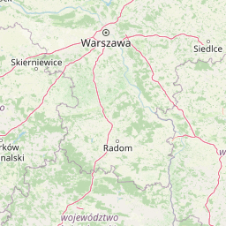
Map view of Kampinos National Park

Use this park location map to pinpoint Kampinos National Park in Poland, understand its exact geographic position, and read its mapped placement within the surrounding landscape more clearly.

Pigeon | © OpenStreetMap contributors

Location context for Kampinos National Park

Masovian Voivodeship
Natural feature types

Analyze the Natural Topography and Landmark Features of Kampinos National Park

Explore the full collection of named natural features that define the geomorphology of Kampinos National Park. MoriAtlas provides a structured view of these inland dune systems and wetland complexes to deepen your understanding of the regional terrain.
Recorded earthquake history

Review Recorded Earthquake History for Kampinos National Park

Examine the historical catalogue of seismic events recorded in the vicinity of Kampinos National Park. This structured collection from MoriAtlas helps identify recorded event patterns and proximity data relative to the park geography without predictive or hazard assessment.

Kampinos National Park Earthquake History

Catalogued events

19 events

Strongest magnitude

Magnitude 4.6

Most recent event

Apr 8, 1993

This history includes earthquakes recorded inside the park or within 50 km of its borders

Park atlas

Compare regional geography, inland dunes, and connected natural landscapes

Explore Protected Areas and Parks Near Kampinos National Park

Browse other notable protected areas situated around the surrounding regional landscape of Kampinos National Park. Expanding the geographic scope connects wetland reserves and forest habitats into a broader atlas comparison view.
A soft watercolor illustration of a marshy landscape with low rolling hills, scattered trees, and a winding stream, rendered in light green and yellow tones on a white background.
National parkMasovian Voivodeship
Park boundaries overlap#1 closest

West

Kampinoski Park Narodowy: Mapping the Inland Dune and Wetland Landscapes of Central Poland

A vital protected area in Masovian Voivodeship

The landscape of Kampinoski Park Narodowy is defined by the Grochalskie Piachy dune complex and diverse riparian habitats. This atlas entry covers the geological history and protected boundaries of this significant lowland forest, tracing the Vistula river valley's influence on the surrounding terrain and ecological character.

Area
385.443 km²
Established
1959
Visitors
1M annual
Relief
Lowland
Protected landscapeLodzkie Voivodeship
2.6 km away#2 closest

Southwest

Sulejowski Park Krajobrazowy: Geography and Protected Landscape Mapping

Central Polish river valley and reservoir terrain

Examine the territorial boundaries and landscape character of Sulejowski Park Krajobrazowy. This protected area integrates riverine corridors, large reservoir habitats, and mixed lowland forests across the Lodzkie Voivodeship, providing a core reference for understanding the ecological geography of the central Pilica valley.

Area
170.26 km²
Established
1994
Relief
Lowland
Climate
Temperate
Nature reserveLodzkie Voivodeship
6 km away#3 closest

South

Łąki Ciebłowickie Nature Reserve: A Central Poland Floodplain Landscape Analysis

Protected riparian ecosystems and riverine lowland geography

Łąki Ciebłowickie represents an ecologically rich floodplain environment within the Lodzkie Voivodeship. This nature reserve preserves a sequence of vital lowland habitats ranging from marshy meadows to oak-hornbeam forests. Analyze the mapped boundaries and natural terrain features that define this protected riverine mosaic in the heart of central Europe.

Area
4.772 km²
Relief
Lowland
Climate
Temperate
Access
Access unknown
A horizontal watercolor painting showing soft, layered green rolling hills and wooded ridges on a white background.
Nature reserveMasovian Voivodeship
About 7.8 km away#4 closest

North

Dolina Wkry Nature Reserve: A Protected River Gorge and Riparian Forest Ecosystem in Masovia

Geographic analysis of breakthrough valley landscapes and lowland river habitats

This protected area centers on a narrow, gorge-like section of the Wkra River, which cuts through the older land surfaces of the Masovian Voivodeship. The reserve protects vital floodplain forest fragments and demonstrates a clear transition from river-edge alder woodlands to drier plateau slopes, providing a compact example of lowland riverine geomorphology.

Area
0.244 km²
Established
1991
Relief
Lowland
Climate
Temperate
Nature reserveŁódź Voivodeship
About 16 km away#5 closest

Southwest

Rezerwat przyrody Małecz: Protected Nature Reserve and Forest Landscape in Łódź Voivodeship

Floristic reserve and managed coniferous forest geography

Rezerwat przyrody Małecz is a key floristic site in Poland, safeguarding rare Pontic-origin flora and ancient forest stands. This reserve showcases the integration of strict protection zones with moist and dry mixed coniferous forest communities within the Spała Forest District, offering deep insight into regional botanical conservation.

Area
0.092 km²
Established
1987
Relief
Lowland
Climate
Temperate
Nature reserveLodzkie Voivodeship
About 19 km away#6 closest

Southwest

Rezerwat przyrody Meszcze Nature Reserve: Mapped Protected Landscape and Forest Ecology

Protected fresh mixed forest within the Sulejów Landscape Park context

Rezerwat przyrody Meszcze represents a compact, protected forest block in central Poland. Known for its historical small-leaved lime regeneration, this reserve provides a key case study for forest structure and lowland biodiversity within the Lodzkie Voivodeship, serving as an important part of the Sulejów Landscape Park's protected corridor.

Area
0.353 km²
Established
1959
Relief
Lowland
Scope
Terrestrial
A soft watercolor illustration of a winding river flowing through a green valley with forested hills in the background.
Nature reserveMazowieckie
About 20 km away#7 closest

Southeast

Rezerwat przyrody Morysin: Protected Floodplain Landscapes and Historic Forest Reserves

A riparian heritage site in the Mazowieckie region

Situated in the Vistula floodplain, Rezerwat przyrody Morysin stands as a significant protected area defined by its massive old-growth trees and layered cultural history. The terrain incorporates diverse wetland features, including the Sobieski Canal and Wilanówka stream, creating a vital habitat for cavity-nesting species and a rare example of integrated natural and historic preservation.

Area
0.535 km²
Established
1996
Relief
Lowland
Climate
Temperate
Watercolor painting of a meandering river landscape with gentle hills, light green foliage in the foreground, and soft washes of color.
Protected landscapeLodz Voivodeship
21 km away#8 closest

Southwest

Bolimowski Park Krajobrazowy: Geography of a Central Polish Protected Landscape Area

Rawka River valley mapping and Puszcza Bolimowska forest terrain

Bolimowski Park Krajobrazowy encompasses a unique mosaic of postglacial plains and riverine ecosystems in central Poland. The area is defined by the Rawka River, which forms a network of meanders, oxbow lakes, and terraces, while surrounding forests retain historical links to the vast primeval woods of Puszcza Bolimowska. This protected territory offers a significant habitat for diverse wildlife, including moose and beaver, within a landscape characterized by its shifting transition between deep forest, wet meadows, and light oak groves.

Area
205.123 km²
Established
1986
Relief
Lowland
Climate
Temperate

Common questions about visiting, size, designation, and location context for Kampinos National Park

Kampinos National Park FAQs for park facts, access, geography, and protected area context

Find quick answers about Kampinos National Park, including protected-area facts, park geography, trail and visitor context, and how the park fits into its surrounding country and regional landscape.
MoriAtlas Explorer

Continue Your Protected Areas Search Across the Global Atlas

Deepen your exploration by continuing the structured search for national parks and protected areas worldwide. Utilize the comprehensive filtering capabilities to compare different conservation landscapes and refine your understanding of global park geography. Discover more about the distribution and characteristics of protected natural areas.

Global natural geography