Mori Atlas logo
National parkPolesie National Park

Discover the mapped boundaries and glacial terrain of this unique wetland ecosystem.

Polesie National Park: A Protected National Park Landscape in Poland's Polesie Region

Polesie National Park stands as a significant protected area within Poland's eastern landscape, representative of the broader, historic Polesie region. This national park is defined by its exceptional wetland ecosystems, featuring extensive marshes, peat bogs, and isolated forest stands on sand dunes, a rare combination across European lowlands. MoriAtlas provides a structured view of this natural territory, highlighting its geographical context and allowing for detailed exploration of its protected boundaries and unique lowland terrain.

wetlandsnational parkPolandPolesie regionpeat bogseastern Europe

Polesie National Park

National park

Park overview

Structured park overview, official facts, and landscape profile for Polesie National Park

Polesie National Park park facts, protected area profile, and essential visitor context

Review the core facts for Polesie National Park, including designation, size, terrain, visitor scale, habitats, and operating context in one park-focused overview.

About Polesie National Park

Polesie National Park was established to protect the remaining fragments of the historic Polesie landscape in Poland. The park encompasses a terrain shaped by glacial and fluvioglacial processes, featuring a mosaic of wetlands, forests, and open ground that represents the ecological character of the broader Polesie region. The area's conservation significance stems from the rarity of intact wetland ecosystems in Poland's lowland regions, where much of the original habitat has been drained for agriculture or altered by human activity. The park serves as a refuge for species adapted to wet, boggy conditions and provides important ecosystem services including water filtration, carbon storage, and flood mitigation.

Quick facts and research context for Polesie National Park

Polesie National Park is located in eastern Poland within the Lublin Voivodeship, protecting a portion of the historic Polesie region. The landscape features a distinctive combination of wetlands, pine forests, and sand dunes created by glacial meltwater processes. The park is recognized for its ecological significance as one of the last major wetland complexes in the Polish lowlands, supporting populations of rare bird species and preserving a landscape that was once part of a much larger transboundary wilderness area.

Protection and recognition

Documenting the international conservation framework and registered boundaries in Poland.

Polesie National Park Protection Status and Natura 2000 Designation

Map records outline the documented protection status of Polesie National Park, emphasizing its formal integration into the Natura 2000 ecological network. Verifying such international designations and official limits provides essential geographic context for understanding the regional spread of protected landscapes.
Park context

Deeper park guide and search-rich context for Polesie National Park

Polesie National Park history, landscape, wildlife, and travel context

Explore Polesie National Park through its history, landscape character, ecosystems, wildlife, conservation priorities, cultural context, and seasonal travel timing in a structured park guide built for atlas discovery and search intent.

Why Polesie National Park stands out

Polesie National Park is best known for its extensive wetland complexes and peat bogs, which form the core of the park's ecological identity. The park protects one of Poland's largest remaining areas of marshland and bog habitat, creating critical breeding and nesting grounds for waterfowl and migratory birds. The juxtaposition of wetland areas with pine forest stands on sand dunes creates a visually distinctive landscape uncommon in the Polish protected areas network.

Polesie National Park history and protected-area timeline

Polesie National Park was formally established in 1990 to protect the representative ecosystems of the eastern Polish portion of the Polesie region. The designation came at a time of growing recognition that the wetlands of eastern Poland represented some of the most ecologically valuable and endangered habitats in the country. Prior to protected status, the area had experienced limited agricultural development compared to other lowland regions of Poland, allowing large areas of natural habitat to survive. The park's creation reflected both ecological priorities and cultural recognition of the Polesie region's distinctive character.

Polesie National Park landscape and geographic character

The landscape of Polesie National Park is characterized by its low-lying terrain shaped by glacial deposition, with sand dunes, peat bogs, and marshy depressions forming the dominant features. The park contains areas of pine forest growing on sandy soils that contrast sharply with the wetland corridors and open bog surfaces. Lakes and ponds dot the landscape, some formed in glacial kettle depressions while others represent remnants of river channels. The overall impression is of a remote, wild landscape that retains much of its natural character despite centuries of human presence in the surrounding region.

Polesie National Park ecosystems, habitats, and plant life

The park protects a complex of interconnected wetland habitats that represent some of the most valuable ecological areas in eastern Poland. Peat bogs of various ages and moisture levels dominate the wetland system, supporting distinctive vegetation communities adapted to acidic, waterlogged conditions. The surrounding pine forests grow on the drier sandy rises between wetland areas, creating a mosaic of habitat types that supports high biodiversity. The wetland nature of the park creates conditions favorable for numerous species that are rare or declining elsewhere in Poland.

Polesie National Park wildlife and species highlights

Polesie National Park provides crucial habitat for waterfowl and wetland birds, with the marsh and bog environments supporting breeding populations of species associated with aquatic habitats. The wetland complexes serve as important feeding and nesting areas during the breeding season, while also functioning as staging areas for migratory birds moving between northern breeding grounds and southern wintering areas. The forest edges and woodland areas support populations of larger mammals, though the park is not known for any particularly distinctive large mammal assemblages.

Polesie National Park conservation status and protection priorities

The park plays a significant role in protecting Poland's remaining lowland wetland heritage. The wetland ecosystems within the park are recognized for their importance in maintaining ecological processes including water cycling, nutrient filtering, and carbon storage in peat deposits. Conservation efforts focus on maintaining natural water levels and preventing the drainage or modification of wetland areas that would degrade the ecological character of the park. The protected status also helps preserve the traditional character of the landscape, which retains much of its wild quality.

Polesie National Park cultural meaning and human context

The Polesie region has a distinctive cultural identity rooted in its history as a peripheral borderland between major state formations. The area has historically been sparsely populated compared to other parts of Poland, with settlement concentrated in villages along the higher ground while the wetlands remained largely unused. This pattern of human settlement created conditions that incidentally preserved large areas of natural habitat, as the difficult terrain limited agricultural expansion. The regional identity remains tied to the wetland landscape and the traditions of the local communities who have lived in proximity to these wild areas.

Top sights and standout views in Polesie National Park

The park's primary ecological value lies in its extensive wetland complexes, which are among the largest remaining in Poland's lowlands. The combination of peat bogs, marshes, and forest-covered dunes creates a distinctive landscape that differs markedly from the agricultural countryside surrounding the protected area. Birdlife is a particular highlight, with the wetlands supporting breeding populations and migratory stopovers for numerous species. The sense of remoteness and wildness remains a defining characteristic of the park experience.

Best time to visit Polesie National Park

The park can be visited throughout the year, though spring and early summer offer the most active wildlife viewing opportunities as birds breed and the wetland vegetation becomes lush. Autumn provides a different character as the bog vegetation takes on autumn colors and fewer visitors are present. Winter exposes the landscape structure more clearly as the wetlands freeze and the deciduous elements become bare, though access may be more limited. The timing of visits should be guided by the specific activities and experiences sought rather than any particularly restricted access periods.
Monthly climate preview

Analyzing representative monthly temperatures and average precipitation cycles

Polesie National Park Weather by Month and Long-Term Climate Normals

Long-term data at a representative elevation of 164.9 meters show average monthly mean temperatures ranging from minus four degrees Celsius up to twenty degrees Celsius. Examining the complete month-by-month dataset reveals detailed minimum and maximum temperature spreads alongside daily rainfall averages for deeper geographic comparison.
Annual mean8 °C
-4 °C21 °C
Jan-4°
Feb-3°
Mar
Apr
May14°
Jun18°
Jul21°
Aug20°
Sep14°
Oct
Nov
Dec-2°
Warmest month
July

20.6 °C

Coolest month
January

-4.2 °C

Wettest month
July

2.5 mm/day

Driest month
January

1.2 mm/day

Park location guide

Geography guide, regional context, and park location map for Polesie National Park

Polesie National Park park geography, regions, and map view in Poland

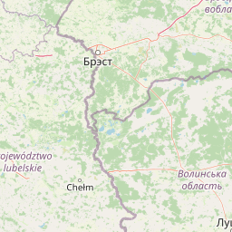
Understand where Polesie National Park sits in Poland through a broader geographic reading of the surrounding landscape, nearby location context, and its mapped position within the national park landscape.

How Polesie National Park fits into Poland

Poland, officially the Republic of Poland, is a Central European country spanning from the Baltic Sea in the north to the Carpathian Mountains in the south. It borders Germany, Czech Republic, Slovakia, Ukraine, Belarus, Lithuania, and Kaliningrad Oblast. The country has a temperate climate, diverse landscapes, and is known for its rich history, cultural heritage, and strong economic position within the EU.

Wider geography shaping Polesie National Park in Poland

Poland occupies 312,696 km2 in Central Europe, extending from the Baltic Sea coast in the north to the Sudetes and Carpathian Mountains in the south. It borders Germany to the west, Czech Republic and Slovakia to the south, Ukraine and Belarus to the east, and Lithuania and Kaliningrad Oblast to the northeast. The landscape includes lowland plains, uplands, and mountain ranges.

Map view of Polesie National Park

Use this park location map to pinpoint Polesie National Park in Poland, understand its exact geographic position, and read its mapped placement within the surrounding landscape more clearly.

Pigeon | © OpenStreetMap contributors

Location context for Polesie National Park

Lublin VoivodeshipWłodawa County
Park atlas

Expand your atlas exploration by tracing the geographic spread of protected areas and wetland ecosystems surrounding Polesie National Park.

Explore Nearby National Parks and Protected Areas Near Polesie National Park, Tracing Poland's Wetland Geography

Continue your discovery from Polesie National Park by exploring a curated selection of national parks and protected areas across eastern Poland and its broader regional context. Compare varied wetland ecosystems, glacial landscapes, and forest reserves, gaining a deeper understanding of the protected-area geography beyond Polesie National Park.
A watercolor painting showing a panoramic view of a marshy landscape with green grasses, light-colored water, and distant trees on a white background.
National parkLublin Voivodeship
Park boundaries overlap#1 closest

East

Poleski Park Narodowy: Protected Wetlands and Glacial Geography in Lublin Voivodeship

Exploration of peatlands, kettle lakes, and boreal-style marshes

Poleski Park Narodowy encompasses a diverse mosaic of fens, transitional bogs, and dense marsh forests within the Lublin Voivodeship. This protected area serves as a primary reference for understanding the glacial-relict biodiversity and flat, water-defined terrain characteristic of the historic Polesie region in eastern Poland.

Area
97.6 km²
Established
1990
Visitors
41K annual
Relief
Lowland
Nature reserveLublin Voivodeship
About 4 km away#2 closest

Southeast

Jezioro Świerszczów Nature Reserve: A Detailed Geographic Atlas of Eastern Polish Protected Lands

Regional peatland and lake basin landscape context

Located in Lublin Voivodeship, Jezioro Świerszczów represents an essential study in lowland mire ecosystems. The reserve protects a small lake and surrounding transitional peatland, supporting a compact landscape mosaic that includes aquatic vegetation, alder carrs, and oak-hornbeam forest zones.

Area
0.461 km²
Established
1959
Relief
Lowland
Climate
Temperate
Watercolor painting of a calm lake surrounded by lush green forests and rolling hills in the background under a soft light.
Nature reserveLubelskie Voivodeship
About 16 km away#3 closest

Northwest

Jezioro Obradowskie Nature Reserve: Geography, Mapped Boundaries, and Protected Peatland Systems

An essential lowland bog and dystrophic lake complex in Lubelskie Voivodeship.

Jezioro Obradowskie Nature Reserve protects a distinct lowland mosaic of dystrophic water, sphagnum mires, and old forest stands. As part of the wider Lasy Parczewskie woodlands and international conservation networks, this site provides significant data for understanding peatland ecology and regional landscape transitions in eastern Poland.

Area
0.827 km²
Established
1975
Relief
Lowland
Climate
Temperate
Nature reserveLubelskie Voivodeship
About 17 km away#4 closest

Northeast

Las Ochoża imienia Marka Kellera: Forest Nature Reserve and Landscape Mapping in Poland

A study of protected wetland forests and early medieval archaeological terrain.

Las Ochoża imienia Marka Kellera protects a critical 193-hectare mosaic of alder swamps and riparian habitats situated in the Zaklęsłość Sosnowicka mesoregion. This nature reserve, integrated into the Natura 2000 Uroczysko Mosty-Zahajki bird protection area, provides a rare window into the natural forest processes of eastern Poland. The site serves as a vital hydrological nexus and features a preserved medieval hillfort on a secluded forest island.

Area
1.929 km²
Established
2024
Relief
Lowland
Scope
Terrestrial
A horizontal watercolor illustration depicting a calm lake with marshy shores, reeds, and distant low hills.
Nature reserveWojewództwo lubelskie
About 18 km away#5 closest

East

Rezerwat przyrody Jezioro Orchowe: Protected Area and Wetland Geography Map

Wetland ecosystems and peatland terrain in Województwo lubelskie.

The Rezerwat przyrody Jezioro Orchowe nature reserve protects a distinct dystrophic lake and surrounding mire complex in eastern Poland. This site offers deep insight into the transition between aquatic, peatland, and forested habitats within a glacial depression of the Bug river valley. Its documented plant communities represent a key reference for understanding the ecological structure of the wider Polesie lowland region.

Area
0.582 km²
Established
1996
Relief
Lowland
Climate
Temperate
Nature reservePoland
About 18 km away#6 closest

Southeast

Rezerwat przyrody Bachus: Protected Nature Reserve and Forest Atlas in Eastern Poland

Mapping sessile oak woodlands and protected landscape boundaries

Rezerwat przyrody Bachus is a notable nature reserve in Poland, recognized for its role in preserving sessile oak within the broader Chełmski Landscape Park. This atlas entry provides geographic context on the reserve, detailing its position within the lowland terrain of the Lubelskie region and its importance as an edge-of-range forest sanctuary.

Area
0.826 km²
Established
1958
Relief
Lowland
Climate
Temperate
Nature reserveLubelskie Voivodeship
About 24 km away#7 closest

East

Rezerwat przyrody Małoziemce: Nature Reserve Protected Areas and Geographic Map Context

A faunal reserve within the Łęczna-Włodawa Lake District

Rezerwat przyrody Małoziemce represents a specialized faunal protected area in Lubelskie Voivodeship. Established for the preservation of heron breeding colonies, the site is defined by its lowland, marshy terrain and its strategic inclusion within the larger Sobiborski Landscape Park. This entry provides detailed geographic perspective on how this forest and wetland complex fits into the regional network of protected landscapes near the Polish-Ukrainian border.

Area
0.38 km²
Established
1988
Scope
Terrestrial
Protected areaLublin Voivodeship
25 km away#8 closest

Southeast

Poleska Dolina Bugu Protected Landscape: Mapped Atlas and Geographic Overview

Key Natura 2000 river valley site in Lublin Voivodeship

Poleska Dolina Bugu is a regionally vital protected area comprising six connected enclaves along the Bug River. The site features a mosaic of oxbow lakes, alkaline fens, molinia meadows, and riparian woodlands that define the lowland geography of eastern Poland. Access structured data on this Habitats Directive site to understand its surface composition, floodplain connectivity, and specialized conservation habitats.

Area
81.732 km²
Relief
Lowland
Scope
Terrestrial
Water
Major water bodies

Common questions about visiting, size, designation, and location context for Polesie National Park

Polesie National Park FAQs for park facts, access, geography, and protected area context

Find quick answers about Polesie National Park, including protected-area facts, park geography, trail and visitor context, and how the park fits into its surrounding country and regional landscape.
MoriAtlas Explorer

Continue Your Protected Areas Search Across the Global Atlas

Deepen your exploration by continuing the structured search for national parks and protected areas worldwide. Utilize the comprehensive filtering capabilities to compare different conservation landscapes and refine your understanding of global park geography. Discover more about the distribution and characteristics of protected natural areas.

Global natural geography