Mori Atlas logo
Protected areaPoleska Dolina Bugu

Mapped riverine corridors, wetland enclaves, and conservation landscapes of eastern Poland

Poleska Dolina Bugu Protected Area in Lublin Voivodeship: Geographic and Landscape Atlas

Poleska Dolina Bugu encompasses a significant Natura 2000 protected landscape within the Lublin Voivodeship of eastern Poland. This region is defined by its complex riverine systems along the Bug River, featuring six distinct enclaves that host a variety of aquatic, wetland, and riparian forest habitats. Our atlas data documents these diverse geographic zones, providing essential context on the floodplain dynamics and ecological surface types that characterize this expansive river valley site.

Natura 2000Habitats DirectiveSpecial Area of Conservationriver valleyfloodplainBug River

Poleska Dolina Bugu

Protected area

Park overview

Structured park overview, official facts, and landscape profile for Poleska Dolina Bugu

Poleska Dolina Bugu park facts, protected area profile, and essential visitor context

Review the core facts for Poleska Dolina Bugu, including designation, size, terrain, visitor scale, habitats, and operating context in one park-focused overview.

About Poleska Dolina Bugu

Poleska Dolina Bugu is a habitat-focused Natura 2000 site situated in the Lubelskie Voivodeship of eastern Poland, within the broader landscape of the Bug River valley. Registered under the code PLH060032, it functions as a Special Area of Conservation under the European Union's Habitats Directive. The site encompasses six interconnected enclaves across a total area of 8,173.24 hectares, anchored geographically around coordinates in the Wola Uhruska commune area near 51.2841°N, 23.6731°E.

As a habitat protection site, its core purpose is the long-term safeguarding of natural habitat types and the populations of selected endangered wild species, excluding birds. The site's protected habitats and species list reflects the ecological character of river valleys in the eastern Polish lowlands, where floodplain dynamics and historical land use have produced a diverse mix of aquatic, wetland, grassland, and woodland environments.

The ecological mosaic of the area combines still-water bodies, peat-forming systems, species-rich meadows, thermophilic grasslands, and extensive riparian forests. This makes the site valuable not only for individual protected species but also for the broader habitat complexes that sustain them. The designation under the Natura 2000 framework links Poleska Dolina Bugu to a wider European effort to preserve biodiversity outside of strictly protected national parks, providing conservation status to a working landscape shaped by river dynamics and traditional land management.

Because the site is structured as several linked enclaves rather than a single block, it functions as a network of habitat patches within the regional landscape, rather than a continuous protected expanse. This structure reflects the way the Bug valley's floodplain has historically supported varied ecological communities in close proximity, distributed across the terrain shaped by the river.

Quick facts and research context for Poleska Dolina Bugu

Poleska Dolina Bugu is classified as a Specjalny obszar ochrony siedlisk (Special Area of Conservation) within the Natura 2000 ecological network, with the official site code PLH060032. It is located in the Lubelskie Voivodeship in eastern Poland, in the Bug River valley region near the border with Ukraine.

The protected territory covers 8,173.24 hectares and is organized into six interconnected enclaves. Conservation targets include natural habitat types such as oxbow lakes, eutrophic water bodies, xerothermic grasslands, molinia meadows, riparian herb communities, extensively used lowland and montane hay meadows, alkaline fens, and willow-poplar-ash-alder riparian forests, together with a set of threatened plant and animal species.

Protection and recognition

Documented terrestrial protection scope and official designation records

Poleska Dolina Bugu Protection Status and Natura 2000 Recognition

Poleska Dolina Bugu maintains a documented terrestrial protection scope supported by verified Natura 2000 recognition sources. Review the official designation details and administrative frameworks governing this conservation area.
Park context

Deeper park guide and search-rich context for Poleska Dolina Bugu

Poleska Dolina Bugu history, landscape, wildlife, and travel context

Explore Poleska Dolina Bugu through its history, landscape character, ecosystems, wildlife, conservation priorities, cultural context, and seasonal travel timing in a structured park guide built for atlas discovery and search intent.

Why Poleska Dolina Bugu stands out

Poleska Dolina Bugu is known for its mosaic of river-valley habitats along the Bug River in eastern Poland, which combines wetlands, meadows, and riparian forests under formal Natura 2000 protection. The site is recognized in conservation terms for protecting threatened species such as the fen angelica (Angelica palustris), large copper and scarce copper butterflies (Lycaena dispar, Lycaena helle), the fire-bellied toad (Bombina bombina), and the European otter (Lutra lutra). Its protected habitat types span aquatic systems (oxbow lakes and eutrophic water bodies), grassland types including xerothermic swards and molinia meadows, peatland systems such as alkaline fens, and extensive riparian woodlands dominated by willows, poplars, alders, and ash. This ecological diversity across a relatively compact network of enclaves gives the site its distinctive conservation identity.

Poleska Dolina Bugu landscape and geographic character

The physical landscape of Poleska Dolina Bugu is that of the Bug River valley in eastern Poland, a lowland region characterized by floodplain dynamics, river-formed water bodies, and a gentle mosaic of aquatic, wetland, meadow, and woodland surfaces. The site lies near the commune of Wola Uhruska in the Włodawa County area, in a section of the Bug valley that is typical of the eastern Polish borderlands.

The terrain includes oxbow lakes (starorzecza) and natural eutrophic water bodies that reflect former river courses of the Bug and its floodplain history. Spring fens, alkaline peatlands (młaki, turzycowiska, mechowiska), and moisture-shifting molinia meadows occupy low-lying ground where water tables have shaped soil and vegetation conditions. Slightly drier and warmer slopes support xerothermic grasslands (murawy kserotermiczne), a distinctive habitat type in this part of Poland associated with drier, sun-exposed, base-rich substrates.

Riparian forests are a key landscape element, including willow-poplar floodplain forests (łęgi wierzbowo-topolowe), ash-alder riparian woodlands (łęgi jesionowo-olszowe), and alder-ash spring mires (olsy źródliskowe). The combination of oxbow lakes, peatlands, thermophilic swards, and riparian woodland creates the structural variety that defines the Bug valley landscape at this site.

Poleska Dolina Bugu ecosystems, habitats, and plant life

Ecologically, Poleska Dolina Bugu represents a complete lowland river-valley habitat complex, integrating aquatic, wetland, grassland, and forest communities within a relatively compact area of 8,173.24 hectares. The site's protected habitats include both still-water systems and terrestrial vegetation types, marking it as a mosaic site rather than a single-habitat designation.

Aquatic and wet systems are central to the site. The protected list includes natural eutrophic water bodies with floating and submerged vegetation communities (Nympheion, Potamion), oxbow lakes, alkaline fens with młaki, turzycowiska, and mechowisk formations, and source-area alder swamp forests (olsy źródliskowe). These habitats provide the hydrological and vegetation conditions that sustain rare aquatic and wetland species.

Grassland systems add another ecological layer, encompassing extensively used lowland and montane hay meadows (Arrhenatherion elatioris), moisture-shifting molinia meadows (Molinion), and xerothermic Festuco-Brometea grasslands enriched by Asplenion septentrionalis and Festucion pallentis components. Riparian herb communities (Convolvuletalia sepium) and montane herb stands (Adenostylion alliariae) round out the habitat spectrum. Together these elements constitute a habitat network that supports species adapted to waterlogged soils, peat substrates, riverbanks, and drier warm slopes.

Poleska Dolina Bugu wildlife and species highlights

Poleska Dolina Bugu protects a focused set of species that depend on the river-valley habitats of the Bug. Insects are strongly represented, including the large copper (Lycaena dispar) and the scarce copper (Lycaena helle), the dusky large blue (Maculinea nausithous) and the scarce large blue (Maculinea teleius), the marsh fritillary (Euphydryas aurinia), the Scarce Fritillary (Hypodryas maturna), the noctuid moth Xylomoia strix, and the Danube clouded yellow (Colias myrmidone). These species indicate the site's value for invertebrate conservation across meadow, wetland, and riparian woodland contexts.

Fish and amphibians on the protected list include the spined loach (Cobitis taenia), the European weatherfish (Misgurnus fossilis), and the fire-bellied toad (Bombina bombina), all of which depend on the aquatic and near-aquatic habitats preserved in the site. The presence of Misgurnus fossilis and Cobitis taenia reflects the still-water and slow-flowing conditions of the Bug valley's oxbow lakes and meadows.

Mammal protection in the area extends to the European otter (Lutra lutra), which depends on the network of river channels, oxbow lakes, and well-vegetated banks. Among protected plants, the fen angelica (Angelica palustris) is listed as a target species. Bird species are not the focus of this Habitats Directive site, as bird protection in the EU Natura 2000 system is handled through parallel Bird Directive designations.

Poleska Dolina Bugu conservation status and protection priorities

The conservation significance of Poleska Dolina Bugu rests on its status as a Natura 2000 Special Area of Conservation under the EU Habitats Directive, with institutional site code PLH060032. As a Specjalny obszar ochrony siedlisk, the site's purpose is the long-term protection of natural habitat types and populations of selected endangered species, excluding birds.

Its conservation value combines habitat-level and species-level targets. The protected habitat types span oxbow lakes, eutrophic water bodies, xerothermic grasslands, molinia meadows, riparian herb communities, extensively managed hay meadows, alkaline fens, willow-poplar-alder riparian forests, and source-area alder wetlands. This list captures the principal ecological structures of the eastern Polish Bug valley lowlands.

Species-level protection extends to insects with strong habitat specificity, such as multiple Maculinea, Lycaena, and Euphydryas butterflies, alongside aquatic species including the weatherfish (Misgurnus fossilis), spined loach (Cobitis taenia), and fire-bellied toad (Bombina bombina). Mammal protection includes the otter (Lutra lutra). The inclusion of the threatened fen angelica (Angelica palustris) adds a rare plant conservation dimension. Through these combined targets, the site contributes to the maintenance of Bug valley biodiversity within the broader Polish and European Natura 2000 framework.

Top sights and standout views in Poleska Dolina Bugu

Poleska Dolina Bugu stands out as a Natura 2000 Special Area of Conservation covering 8,173.24 hectares across six linked enclaves in the Lubelskie Voivodeship. Its strength lies in the diversity of habitat types preserved within a relatively focused river-valley setting, from oxbow lakes and eutrophic water bodies through molinia meadows and xerothermic grasslands to willow-poplar-alder riparian forests and source-area alder mires.

The site is also notable for the breadth of its species targets, which include specialized butterflies such as Lycaena helle, Lycaena dispar, Maculinea nausithous, Maculinea teleius, Euphydryas aurinia, Hypodryas maturna, and Colias myrmidone, aquatic species such as Misgurnus fossilis, Cobitis taenia, and Bombina bombina, the European otter, and the rare fen angelica. Together these features make it a meaningful component of the Polish stretch of the European Habitats Directive network along the Bug valley.

Monthly climate preview

Long-term monthly temperature and precipitation patterns sampled across representative park coordinates

Poleska Dolina Bugu Climate Normals and Annual Temperature Rhythm

Representative coordinate records show average monthly temperatures ranging from sub-zero winter minimums to warm summer maximums alongside consistent precipitation rhythms. Analyzing the complete twelve-month climatology dataset reveals detailed monthly shifts in thermal and moisture conditions across the protected terrain.
Annual mean8 °C
-4 °C21 °C
Jan-4°
Feb-3°
Mar
Apr
May14°
Jun18°
Jul21°
Aug20°
Sep14°
Oct
Nov
Dec-3°
Warmest month
July

20.6 °C

Coolest month
January

-4.5 °C

Wettest month
July

2.6 mm/day

Driest month
January

1.2 mm/day

Park location guide

Geography guide, regional context, and park location map for Poleska Dolina Bugu

Poleska Dolina Bugu park geography, regions, and map view in Poland

Understand where Poleska Dolina Bugu sits in Poland through a broader geographic reading of the surrounding landscape, nearby location context, and its mapped position within the national park landscape.

How Poleska Dolina Bugu fits into Poland

Poland, officially the Republic of Poland, is a Central European country spanning from the Baltic Sea in the north to the Carpathian Mountains in the south. It borders Germany, Czech Republic, Slovakia, Ukraine, Belarus, Lithuania, and Kaliningrad Oblast. The country has a temperate climate, diverse landscapes, and is known for its rich history, cultural heritage, and strong economic position within the EU.

Wider geography shaping Poleska Dolina Bugu in Poland

Poland occupies 312,696 km2 in Central Europe, extending from the Baltic Sea coast in the north to the Sudetes and Carpathian Mountains in the south. It borders Germany to the west, Czech Republic and Slovakia to the south, Ukraine and Belarus to the east, and Lithuania and Kaliningrad Oblast to the northeast. The landscape includes lowland plains, uplands, and mountain ranges.

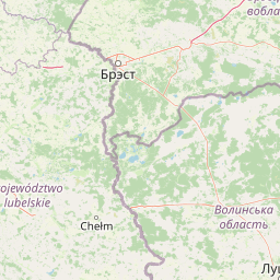
Map view of Poleska Dolina Bugu

Use this park location map to pinpoint Poleska Dolina Bugu in Poland, understand its exact geographic position, and read its mapped placement within the surrounding landscape more clearly.

Pigeon | © OpenStreetMap contributors

Location context for Poleska Dolina Bugu

Lublin Voivodeship
Park atlas

Compare regional river valley landscapes and neighboring lowland habitats

Parks Near Poleska Dolina Bugu: Explore Related Protected Areas

Continue exploring protected areas near Poleska Dolina Bugu by browsing adjacent river valley habitats and lowland terrain across eastern Poland. Comparing related conservation zones helps place regional wetland ecosystems and floodplain reserves into a broader geographical context.
Nature reserveLubelskie Voivodeship
About 0.7 km away#1 closest

Northwest

Rezerwat przyrody Małoziemce: Nature Reserve Protected Areas and Geographic Map Context

A faunal reserve within the Łęczna-Włodawa Lake District

Rezerwat przyrody Małoziemce represents a specialized faunal protected area in Lubelskie Voivodeship. Established for the preservation of heron breeding colonies, the site is defined by its lowland, marshy terrain and its strategic inclusion within the larger Sobiborski Landscape Park. This entry provides detailed geographic perspective on how this forest and wetland complex fits into the regional network of protected landscapes near the Polish-Ukrainian border.

Area
0.38 km²
Established
1988
Scope
Terrestrial
Protected landscapeLublin Voivodeship
About 3.9 km away#2 closest

Southeast

Strzelecki Park Krajobrazowy: Protected Landscape Geography and Mapped Natural Terrain

A forest-rich protected area along the Bug River in Poland.

Strzelecki Park Krajobrazowy is defined by its extensive pine forests and the expansive valley of the Bug River. This protected landscape contains a network of oxbow lakes, diverse wetland pockets, and vital bird habitats, mapping a distinct ecological corridor within the Lublin Voivodeship region of eastern Poland.

Area
120.26 km²
Established
1983
Relief
Lowland
Scope
Terrestrial
Nature reserveLublin Voivodeship
About 4.4 km away#3 closest

North

Rezerwat przyrody „Sugry” imienia Janusza Szostakiewicza: A Geographic and Ecological Atlas Entry

Lichen-rich inland pine woodlands in Lublin Voivodeship, Poland.

Rezerwat przyrody „Sugry” imienia Janusza Szostakiewicza encompasses 44 hectares of post-agricultural sandy terrain where natural succession has produced a rare inland dry pine forest. This site is internationally recognized for its dense concentration of lichen taxa and its location within the vital environmental corridor of the Bug River valley. It offers significant insights into the recovery of lowland ecosystems and serves as a permanent reference for conservation efforts in the eastern Polish landscape.

Area
0.442 km²
Established
2021
Relief
Lowland
Climate
Temperate
A horizontal watercolor illustration depicting a calm lake with marshy shores, reeds, and distant low hills.
Nature reserveWojewództwo lubelskie
About 9.8 km away#4 closest

North

Rezerwat przyrody Jezioro Orchowe: Protected Area and Wetland Geography Map

Wetland ecosystems and peatland terrain in Województwo lubelskie.

The Rezerwat przyrody Jezioro Orchowe nature reserve protects a distinct dystrophic lake and surrounding mire complex in eastern Poland. This site offers deep insight into the transition between aquatic, peatland, and forested habitats within a glacial depression of the Bug river valley. Its documented plant communities represent a key reference for understanding the ecological structure of the wider Polesie lowland region.

Area
0.582 km²
Established
1996
Relief
Lowland
Climate
Temperate
A watercolor illustration showing a soft, stylized landscape of rolling green hills, distant mountains, and coniferous trees against a white background.
Protected landscapeLublin Voivodeship
About 12 km away#5 closest

Southwest

Chełmski Park Krajobrazowy: A Detailed Atlas of the Protected Landscape in Lublin Voivodeship

Exploring the calcareous peatlands and diverse wetland topography

Located in eastern Poland, Chełmski Park Krajobrazowy is a protected landscape shaped by unique geological features and rich botanical habitats. This overview explores the park's transition from upland hills to lowland depressions, its internal nature reserves, and its function as a critical biodiversity center within the Lublin Voivodeship landscape.

Area
164.57 km²
Established
1983
Relief
Upland
Climate
Temperate
Nature reserveLubelskie Voivodeship
About 13 km away#6 closest

Northwest

Las Ochoża imienia Marka Kellera: Forest Nature Reserve and Landscape Mapping in Poland

A study of protected wetland forests and early medieval archaeological terrain.

Las Ochoża imienia Marka Kellera protects a critical 193-hectare mosaic of alder swamps and riparian habitats situated in the Zaklęsłość Sosnowicka mesoregion. This nature reserve, integrated into the Natura 2000 Uroczysko Mosty-Zahajki bird protection area, provides a rare window into the natural forest processes of eastern Poland. The site serves as a vital hydrological nexus and features a preserved medieval hillfort on a secluded forest island.

Area
1.929 km²
Established
2024
Relief
Lowland
Scope
Terrestrial
Watercolor depiction of a lake with reeds, forested shoreline, and distant mountains
National parkUkraine
About 14 km away#7 closest

North

Shatsk National Natural Park: Ukraine's Deepest Lake and Wetland Protected Area Atlas

Mapped landscape and protected geography of a premier Ukrainian national park.

Shatsk National Natural Park in Ukraine is a significant protected area featuring a remarkable cluster of over thirty lakes, most notably Svitiaz Lake, the nation's deepest. This park protects vital wetland and forest ecosystems within the Polissia region, offering a rich geographic context for atlas exploration. Understanding its mapped boundaries and terrain provides insight into its importance as a Ramsar site and a key corridor for migratory birds, making it a cornerstone of conservation geography in Eastern Europe.

Area
489.77 km²
Established
1983
IUCN
II
Relief
Lowland
A horizontal watercolor illustration of a marshy landscape featuring a winding stream, soft green grasses, and clusters of wetland vegetation against a light background.
Nature reserveLubelskie Voivodeship
About 14 km away#8 closest

Southwest

Rezerwat przyrody Bagno Serebryskie: Protected Wetland and Calcareous Fen Geography in Lubelskie

Mapped terrain and ecological boundaries of a Polish nature reserve.

Investigate the environmental character of Rezerwat przyrody Bagno Serebryskie, an expansive protected wetland in eastern Poland. This site preserves rare alkaline-loving plant communities and vital avian habitats, showcasing the complex marshy terrain and geographic significance of the Lubelskie Voivodeship region.

Area
3.766 km²
Established
1991
Relief
Lowland
Scope
Terrestrial

Common questions about visiting, size, designation, and location context for Poleska Dolina Bugu

Poleska Dolina Bugu FAQs for park facts, access, geography, and protected area context

Find quick answers about Poleska Dolina Bugu, including protected-area facts, park geography, trail and visitor context, and how the park fits into its surrounding country and regional landscape.
MoriAtlas Explorer

Continue Your Protected Areas Search Across the Global Atlas

Deepen your exploration by continuing the structured search for national parks and protected areas worldwide. Utilize the comprehensive filtering capabilities to compare different conservation landscapes and refine your understanding of global park geography. Discover more about the distribution and characteristics of protected natural areas.

Global natural geography