
Mori Atlas logo
Protected landscapeDoupovská pahorkatina Nature Park

Tracing volcanic upland geography, rare steppe grasslands, and forest-steppe mosaic terrains.

Doupovská pahorkatina Nature Park: An Essential Protected Landscape in Chomutov District

(Přírodní park Doupovská pahorkatina)

Doupovská pahorkatina Nature Park serves as a distinct protected area spanning roughly 4,770 hectares within the Chomutov District of the Czech Republic. This region preserves a unique mosaic of dry steppe grasslands, forest-steppe habitats, and deciduous woodland stands that transition from the volcanic Doupov Mountains to the basin of the Liboc river. The terrain features rolling upland hills ranging from 320 to 540 meters, punctuated by rocky outcrops and river-fed wetlands that define this continental climate zone.

nature parksteppe grasslandforest-steppedeciduous woodlanddry grasslandsprotected landscape
A graphic illustration showing a waterfall flowing down between cliffs, surrounded by trees, tall grass, and soft, stylized clouds.

Doupovská pahorkatina Nature Park

Protected landscape

Park overview

Structured park overview, official facts, and landscape profile for Doupovská pahorkatina Nature Park

Doupovská pahorkatina Nature Park park facts, protected area profile, and essential visitor context

Review the core facts for Doupovská pahorkatina Nature Park, including designation, size, terrain, visitor scale, habitats, and operating context in one park-focused overview.

About Doupovská pahorkatina Nature Park

Doupovská pahorkatina Nature Park occupies a culturally and ecologically transitional zone in northwestern Bohemia, where the rolling slopes of the Doupovské hory descend toward the Liboc river basin. Although the protected area is more than 4,700 hectares in extent, it retains a distinctly rural character: outside the small towns of Radonice and Mašťov, the landscape is sparsely populated, with only scattered settlements and small village parts scattered across the rolling terrain.

The park's identity is shaped largely by its climatic and geological conditions. The Doupovská pahorkatina region is one of the warmer and drier parts of the Czech Republic, and its underlying geology is linked to the volcanic past of the Doupov Mountains. Soils derived from these volcanic materials, combined with relatively low annual rainfall, support an ecosystem type that is otherwise rare in central Europe: extensive steppe and forest-steppe habitats interspersed with patches of deciduous and mixed woodland.

What distinguishes the park from many other Czech protected areas is the dominance of these open dry grassland communities and the rich mosaic they create with surrounding woodland. Rather than being characterized primarily by dense forest or alpine conditions, the area presents broad vistas of open slopes, meadows, and rocky outcrops, broken by tree clusters and riparian corridors along the streams. The Liboc river and its tributaries, especially the Dubá, form natural structuring axes across this landscape, while small water bodies, including the Sedlec pond and Dobřenecký pond, provide wetland refuges within the otherwise dry upland matrix.

The designation of the nature park in 1996 was explicitly motivated by the need to protect this unusual combination of habitats and the threatened species they harbor. As a result, the park represents an important node in the regional ecological network, complementing the larger Vojenský újezd Hradiště military training area to the west and other protected areas across the broader Doupov region.

Quick facts and research context for Doupovská pahorkatina Nature Park

Doupovská pahorkatina Nature Park is located in the Chomutov district of the Ústí nad Labem region in northwestern Bohemia, with a small portion along the border of the Louny district. The territory was designated in 1996 by the District Office in Chomutov, covering approximately 4,770 hectares at elevations ranging from about 320 to 540 meters above sea level.

The protected area lies mainly within the eastern subdivision of the Doupovské hory geomorphological unit, with a narrow band along the Liboc river belonging to the Žatecká pánev basin. Its main watercourse is the Liboc river, whose tributaries, including the Dubá and the Leska, drain the park's varied terrain. The largest settlement in the area is Radonice, with the historic town of Mašťov near the park's center.

Park context

Deeper park guide and search-rich context for Doupovská pahorkatina Nature Park

Doupovská pahorkatina Nature Park history, landscape, wildlife, and travel context

Explore Doupovská pahorkatina Nature Park through its history, landscape character, ecosystems, wildlife, conservation priorities, cultural context, and seasonal travel timing in a structured park guide built for atlas discovery and search intent.

Why Doupovská pahorkatina Nature Park stands out

The nature park is especially known for its extensive steppe and forest-steppe grasslands, which are unusual within the Czech Republic and form a defining feature of the protected landscape. These dry, sun-exposed slopes and open meadow patches support threatened plant species that depend on warm, continental conditions. It is also recognized for its deciduous woodland stands, which interlock with the open grassland mosaic to create a varied semi-natural habitat pattern. The park functions as a refuge for several protected plant species such as koniklec luční český, upolín nejvyšší, and okrotice bílá, and provides breeding habitat for uncommon bird species tied to steppe and open woodland environments.
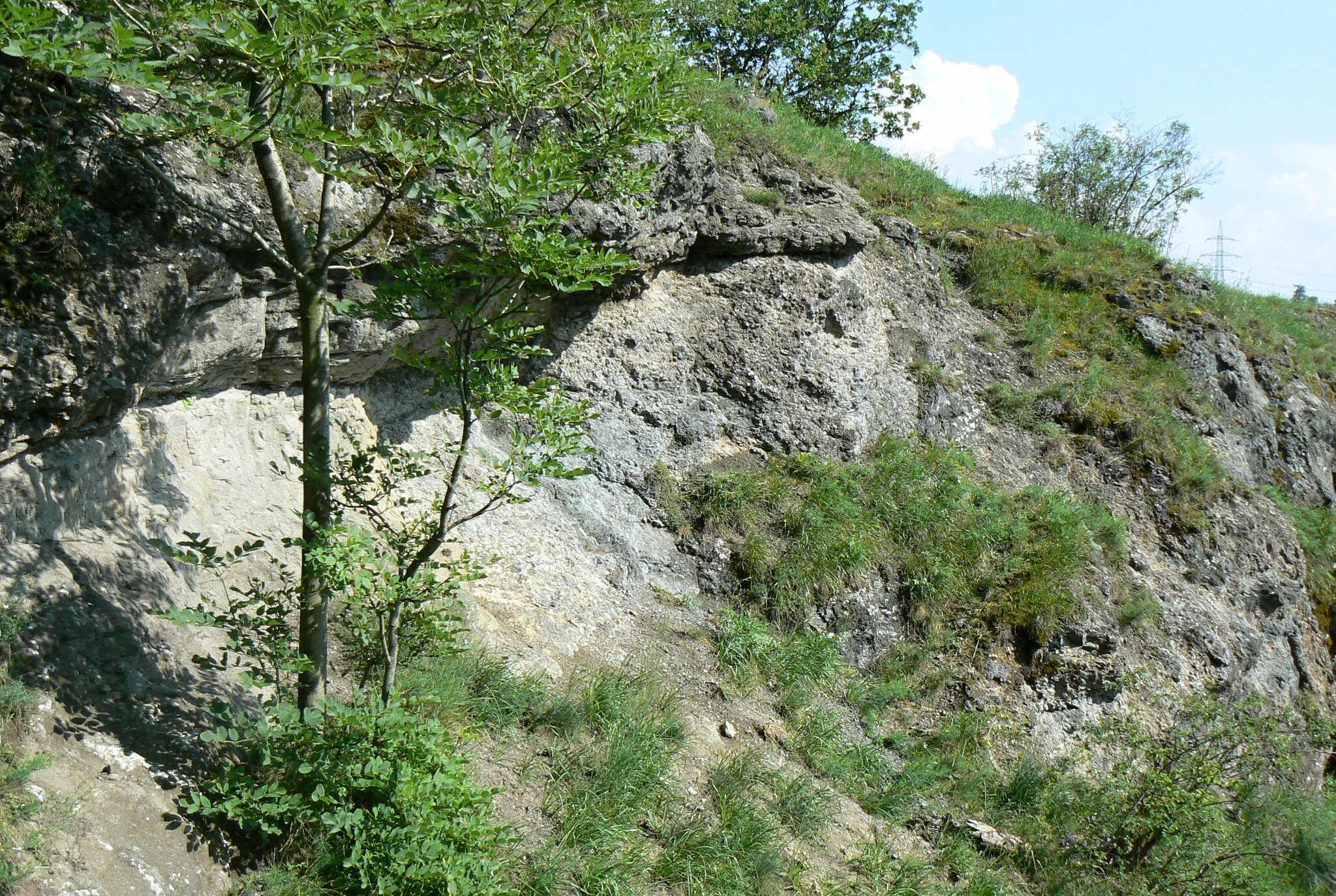
A sloped, rocky hillside with exposed trachybasalt geological formations partially covered by grasses, shrubs, and small deciduous trees.
Trachybasalt rock formations in Doupovska pahorkatina Nature Park.

Doupovská pahorkatina Nature Park history and protected-area timeline

The nature park was formally established in 1996 through a declaration by the District Office in Chomutov. Its designation responded to long-running concerns about the conservation value of the dry steppe and forest-steppe habitats that dominate the eastern foothills of the Doupov Mountains, an area whose climatic and geological conditions make it unusually valuable for thermophilous plant and insect communities.

Closely tied to the park's identity is its location adjacent to the Vojenský újezd Hradiště, a large military training area to the west. The long-term restricted access and limited intensive agriculture in parts of the broader region have helped preserve tracts of semi-natural habitats that would otherwise have been lost to agricultural intensification or afforestation elsewhere in Bohemia. While the nature park itself is a more recent, formally delimited designation, the persistence of its open grassland character is the product of broader land-use patterns extending back through the twentieth century.

Within the park, additional protective measures have been applied to specific localities. The Sedlec natural reserve, located near the western edge of the park around the Sedlec pond, was established specifically to protect the wetland communities associated with that water body. The nature park thus operates as an umbrella designation under which more strictly protected small reserves sit.

Doupovská pahorkatina Nature Park landscape and geographic character

The terrain of the nature park is shaped by its position along the eastern margin of the Doupovské hory geomorphological unit, whose volcanic origins are reflected in the rolling morphology and mineral character of local soils. Within the park, a roughly one-kilometer-wide strip along the Liboc river belongs to the Žatecká pánev basin and the Pětipeská kotlina subunit, lowering the landscape toward the river.

Elevations across the park range from about 320 meters near the river valleys to about 540 meters on the highest surrounding hills. The result is a softly undulating upland rather than a dramatic mountain landscape, with broad, sun-exposed slopes, gently rounded ridges, and occasional rocky promontories. The most prominent local landform is Mašťovský vrch, visible from many parts of the park, while rocky outcrops near Radechov illustrate the residual volcanic and structural character of the terrain.

The hydrological structure of the area reinforces this landscape identity. The Liboc river enters from the west and initially flows east, before turning northeast near Radechov. Its tributary, the Dubá, drains much of the central park, while the Leska follows the southern boundary without fully entering the protected area. Ponds and small reservoirs, including the Sedlec and Dobřenecký ponds and those around Mašťovský vrch, add texture to the landscape and create localized wetland zones within the otherwise dry environment.

Doupovská pahorkatina Nature Park ecosystems, habitats, and plant life

The ecological character of Doupovská pahorkatina Nature Park is defined by the unusual abundance of dry steppe and forest-steppe habitats within the Czech Republic. These communities, dominated by warm-climate grasses and flowering herbs, occupy sun-exposed slopes where soils derived from volcanic bedrock are shallow and well-drained. Interspersed with these open areas are broadleaf woodlands, primarily composed of oak and other deciduous species, creating the characteristic steppe-forest mosaic that gives the park its distinctive ecological profile.

The park functions as a refuge for several protected and threatened plant species that depend on the dry, continental conditions. Notable records include koniklec luční český, a Czech subspecies of the pasqueflower restricted to dry grasslands, upolín nejvyšší, a globe-flower species associated with moist meadows, and okrotice bílá, a rare orchid. The juxtaposition of dry slopes with riparian habitats along the Liboc, Dubá, and smaller streams supports a range of plant communities that would be difficult to maintain in a more uniform landscape.

Wetland habitats, while not the dominant feature of the park, play a critical ecological role. The Sedlec pond area, protected as a separate natural reserve, is the most important wetland site in the park, with smaller contributions from Dobřenecký pond and the ponds clustered around Mašťovský vrch. These wetlands introduce a contrasting set of plant and animal communities into an otherwise dry landscape and act as stepping stones that strengthen ecological connectivity in the wider region.

Doupovská pahorkatina Nature Park wildlife and species highlights

The combination of open steppe, forest-steppe mosaics, and small wetlands supports a varied bird fauna that includes several species of conservation interest. The park's open, sun-warmed slopes and scrubby edges are particularly valuable for ground-nesting and shrub-nesting species. The common nightingale breeds in the park, and the red-backed shrike is a characteristic species of its woodland edges and scrub habitats. The penduline tit, a species linked to riparian vegetation along lowland rivers, also nests here, reflecting the influence of the Liboc river corridor.

Larger raptors have also been recorded in or near the park, with observations of the black stork, red kite, and white-tailed eagle, although breeding status for these species within the park boundaries is not always clearly documented. The presence of these raptors underlines the importance of the area's combination of open hunting grounds and undisturbed woodland patches.

Invertebrate communities typical of warm, dry grasslands are likely to be a significant component of the park's wildlife, although the source material does not provide detailed species lists. The dry conditions, floral richness, and continuity of open grassland habitat suggest particularly strong insect diversity, which in turn supports the bird species tied to steppe environments.

Doupovská pahorkatina Nature Park conservation status and protection priorities

Conservation is the central purpose of Doupovská pahorkatina Nature Park. The designation was driven explicitly by the need to protect extensive steppe and forest-steppe communities with their associated threatened plant and animal species. Within the broader Czech protected-area network, the park occupies a distinctive niche, representing one of the more important refuges for thermophilous dry grassland communities in Bohemia.

The park's conservation value is heightened by its location within a larger landscape mosaic. To the west lies the Vojenský újezd Hradiště military training area, whose long-term restricted land use has inadvertently preserved extensive tracts of semi-natural habitat. Together, the nature park and the surrounding military area form a substantial block of relatively undisturbed dry upland landscape in northwestern Bohemia, rare in a region otherwise heavily affected by industrial and agricultural change.

Within the park itself, conservation efforts are reinforced by the Sedlec natural reserve near the western edge, which provides stricter protection for the wetland communities around Sedlec pond. The layered protection system, from the broad nature park designation to these more strictly reserved zones, reflects an understanding that the ecological value of the area depends on a combination of pastoral open habitats, deciduous woodland, and small wetland refuges.

Doupovská pahorkatina Nature Park cultural meaning and human context

The cultural fabric of the park is dominated by small rural settlements and several historic monuments. The town of Mašťov, located near the geographic center of the park, retains a historic urban core and a chateau, while Radonice, the largest settlement in the area, has a notable town square. Scattered smaller localities, including the village of Radechov and various hamlet-sized parts of the larger municipalities, contribute to the dispersed settlement pattern that characterizes the park today.

Just beyond the park boundary to the south, the chateau at Vintířov with its English-style park forms a closely linked cultural landmark, illustrating the broader pattern of aristocratic estates and designed landscapes around the Doupov foothills. Smaller religious and civic monuments throughout the area complete the cultural inventory, although the park itself is primarily valued for its natural rather than cultural heritage.

Top sights and standout views in Doupovská pahorkatina Nature Park

The park's most distinctive highlight is its extensive mosaic of steppe, forest-steppe, and deciduous woodland, an ecological pattern seldom matched elsewhere in central Europe at this elevation. Specific draws include the rocky slopes near Radechov, the panoramic views from and around Mašťovský vrch, and the contrast between dry uplands and the wetland reserve of Sedlec pond on the western edge of the park.

Its floral richness is another major highlight: the protected populations of koniklec luční český, upolín nejvyšší, and okrotice bílá anchor the park's botanical interest, while breeding populations of nightingale, red-backed shrike, and penduline tit underscore its ornithological value. Together, these features make the park a compact but ecologically dense destination within the network of Czech protected landscapes.

Best time to visit Doupovská pahorkatina Nature Park

The park's character shifts noticeably with the seasons, and the most rewarding visits often align with the warmer months when the steppe grasslands are at their most expressive. Spring is a particularly favorable period, as flowering of protected plant species such as koniklec brings the dry slopes to life and migrant birds reoccupy breeding territories in the woodland edges and river corridors.

Early summer continues to offer strong bird activity, with species such as the common nightingale and red-backed shrike most easily detected then. Late summer and early autumn can be attractive for their softer light over the open landscape and quieter visiting conditions, although the most vivid displays of steppe flora are earlier in the year. Winter visits have a different appeal, emphasizing the structural contrast between bare deciduous woodland, open grassy slopes, and the occasional frozen pond surfaces, though the park is then quieter for both birds and visitors.

Monthly climate preview

Long-term representative point measurements tracking monthly temperature and precipitation rhythm

Doupovská pahorkatina Nature Park Climate Normals and Annual Temperature Patterns

Representative coordinates record long-term temperature swings from sub-zero winter minimums to warm summer highs alongside steady daily precipitation rates. Opening the full twelve-month profile details complete monthly averages and historical climate trends across the terrain.
Annual mean7 °C
-3 °C18 °C
Jan-3°
Feb-2°
Mar
Apr
May12°
Jun16°
Jul18°
Aug18°
Sep13°
Oct
Nov
Dec-2°
Warmest month
July

17.8 °C

Coolest month
January

-2.7 °C

Wettest month
July

2.7 mm/day

Driest month
April

1.4 mm/day

Park location guide

Geography guide, regional context, and park location map for Doupovská pahorkatina Nature Park

Doupovská pahorkatina Nature Park park geography, regions, and map view in Czechia

Understand where Doupovská pahorkatina Nature Park sits in Czechia through a broader geographic reading of the surrounding landscape, nearby location context, and its mapped position within the national park landscape.

How Doupovská pahorkatina Nature Park fits into Czechia

Czech Republic is a landlocked Central European country with a population of approximately 10.9 million people. The nation was established as an independent state on January 1, 1993, following the dissolution of Czechoslovakia. Its capital and largest city is Prague, with other major urban centers including Brno, Ostrava, Plzeň, and Liberec.

Wider geography shaping Doupovská pahorkatina Nature Park in Czechia

The Czech Republic is a landlocked country in Central Europe. It is bordered by Germany to the west, Austria to the south, Poland to the northeast, and Slovakia to the southeast. The landscape is predominantly hilly, with the territory covering 78,871 square kilometers.

Map view of Doupovská pahorkatina Nature Park

Use this park location map to pinpoint Doupovská pahorkatina Nature Park in Czechia, understand its exact geographic position, and read its mapped placement within the surrounding landscape more clearly.

Pigeon | © OpenStreetMap contributors

Location context for Doupovská pahorkatina Nature Park

Chomutov District

Visualizing the dry grasslands, volcanic terrain, and forest-steppe habitats

Doupovská pahorkatina Nature Park Photos and Landscapes

Examine detailed photographs showcasing the rolling volcanic topography, sun-exposed steppe grasslands, and deciduous woodland mosaics of Doupovská pahorkatina Nature Park. Visual research helps interpret the protected landscape character, dry upland terrain, and unique habitat structures defining the region.

A sloped, rocky hillside with exposed trachybasalt geological formations partially covered by grasses, shrubs, and small deciduous trees.

Park atlas

Compare regional volcanic terrain, dry grasslands, and connected bohemian protected areas

Explore Parks Near Doupovská pahorkatina Nature Park and Surrounding Protected Landscapes

Browsing other protected areas near Doupovská pahorkatina Nature Park reveals similar volcanic terrain and dry grassland ecosystems across the surrounding Bohemian region. Expanding the geographic comparison connects local upland habitats with broader regional conservation networks.
Natural monumentÚstí nad Labem Region
About 7.1 km away#1 closest

South

Vrbina u Nové Vsi Natural Monument: Protected Habitat Mapping and Geographic Overview

Wetland and meadow conservation in the Ústí nad Labem Region

Vrbina u Nové Vsi provides a deep look into the habitat mosaic of the Doupov Mountains foothills. This protected area stands out for its concentrated distribution of ten distinct biotopes, ranging from wet alder woodlands to orchid-rich meadows, providing a comprehensive example of lowland conservation within a larger volcanic terrain context.

Area
0.113 km²
Established
2016
IUCN
IV
Relief
Upland
Natural monumentKarlovarský kraj
About 8.3 km away#2 closest

South

Valeč Natural Monument: Geologic and Ecological Landscapes in the Karlovarský kraj

Tracing volcanic terrain and fossil sites in the Doupovské Hory

Valeč Natural Monument offers a deep look into the volcanic geology and protected wilderness of western Bohemia. Known for its historical paleontological finds and diverse forest cover, this landscape provides an essential case study for mineralogical research and habitat preservation within the wider regional geography.

Area
5.436 km²
Established
1992
IUCN
IV
Relief
Mountain
Nature reserveÚstecký kraj
About 8.3 km away#3 closest

Northeast

Vinařský rybník Nature Reserve: Geographic Map and Protected Wetland Landscape

Lowland basin geography and habitat boundaries in Ústecký kraj.

Vinařský rybník represents a vital nature reserve and lowland wetland in the Ústecký kraj region, showcasing a distinct landscape of shallow ponds, reedbeds, and alluvial sediments. This site forms a key component of the regional avian habitat network, offering a concentrated look at the geological and hydrological features of the Žatecká pánev basin through detailed landscape mapping.

Area
0.151 km²
Established
1990
IUCN
IV
Relief
Upland
Natural monumentKarlovy Vary District
About 9.3 km away#4 closest

South

Valečské sklepy Natural Monument and Protected Bat Hibernation Site in Karlovy Vary

Volcanic terrain and critical wildlife infrastructure in western Bohemia

Valečské sklepy represents a unique form of protected landscape in the Karlovy Vary District, where historical underground cellars function as a specialized natural monument. The site maintains a crucial role as a winter hibernation refuge for the critically endangered western barbastelle, embedded within the volcanic geomorphology of the Doupovské hory region.

Established
2016
IUCN
III
Relief
Mountain
Climate
Temperate
A watercolor painting showing a rolling landscape with green hills, scattered trees, blossoming pink trees, and several large dark boulders in the foreground.
Natural monumentÚstecký kraj
About 11 km away#5 closest

North

Sluňáky Natural Monument: Geological Mapping and Protected Landscape Context

A preserved quartzite boulder field in the Ústecký kraj

Sluňáky represents a vital geological record within the Czech Republic, encompassing a distinctive group of silicified sandstone boulders. This natural monument serves as an important protected territory that illustrates the intersection of Tertiary geology and historical industrial extraction. The surrounding terrain reflects the complex volcanic and sedimentary history of the Doupovské hory foothills.

Area
0.032 km²
Established
1966
IUCN
III
Relief
Upland
Natural monumentKarlovarský kraj
About 17 km away#6 closest

Northwest

Malý Stolec Natural Monument: Volcanic Landscape and Regional Protected Area Atlas

Exposing neovolcanic rock and ancient feeder conduits in Karlovarský kraj

Malý Stolec provides a focused view into the volcanic processes of the Doupovské hory. This natural monument displays rare geologic features including columnar jointing, coarse agglomeratic tuffs, and an intruded lava body. Its location on the southern slopes above the Ohře river offers a distinct landscape character that demonstrates how localized protected areas contribute to broader European conservation frameworks.

Area
0.06 km²
Established
2016
IUCN
IV
Relief
Mountain
A minimalist watercolor painting depicting rolling hills and a meadow landscape in soft shades of green and pink.
Natural monumentÚstí nad Labem Region
About 20 km away#7 closest

East

Soběchlebské terasy Natural Monument: Geography and Protected Ravine Landscapes

Regional protected area analysis in the Ústí nad Labem Region

Soběchlebské terasy is a specialized natural monument situated in the Louny district, protecting a deep, narrow stream valley carved by the Černocký stream. The landscape is characterized by its steep, terraced woodland slopes, providing an essential thermophilic environment for rare orchids and oak-dominated forest fragments within the northwestern Czech Republic.

Area
0.026 km²
Established
2011
IUCN
IV
Relief
Upland
A watercolor painting showing a river valley with coniferous trees, rocky riverbanks, and distant rolling hills in a soft, pastel palette.
Protected landscapeCzechia
About 20 km away#8 closest

South

Přírodní park Horní Střela: Protected Landscape and Geography in Czechia

Geological canyons and basalt uplands in western Bohemia

Přírodní park Horní Střela showcases a layered landscape shaped by the Střela River. The area features deep canyons, rocky slate slopes, and characteristic basalt-topped summits that create a diverse ecological mosaic within the Czech landscape.

Area
99.92 km²
Established
1978
Relief
Upland
Climate
Temperate

Common questions about visiting, size, designation, and location context for Doupovská pahorkatina Nature Park

Doupovská pahorkatina Nature Park FAQs for park facts, access, geography, and protected area context

Find quick answers about Doupovská pahorkatina Nature Park, including protected-area facts, park geography, trail and visitor context, and how the park fits into its surrounding country and regional landscape.
MoriAtlas Explorer

Continue Your Protected Areas Search Across the Global Atlas

Deepen your exploration by continuing the structured search for national parks and protected areas worldwide. Utilize the comprehensive filtering capabilities to compare different conservation landscapes and refine your understanding of global park geography. Discover more about the distribution and characteristics of protected natural areas.

Global natural geography