
Mori Atlas logo
National parkDrawieński Park Narodowy

Mapping the protected lowland terrain, interconnected river systems, and mature beech woodlands of western Poland

Drawieński Park Narodowy: A Detailed Atlas of Glacial Landscapes and Forested River Valleys in Poland

Drawieński Park Narodowy represents a significant protected landscape situated on the Równina Drawska, a postglacial lowland plain in northwestern Poland. This territory is characterized by an extensive network of river valleys, particularly those of the Drawa and Płociczna, alongside approximately twenty lake basins including the distinctive humic Lake Czarnka. The park serves as a vital expanse of continuous beech and oak-beech forests, providing a stable habitat and preserved natural terrain that illustrates the postglacial geography of the region.

lowland forestbeech woodlandglacial lakesriver valleyspostglacial landscapepeatland

Drawieński Park Narodowy

National park

Park overview

Structured park overview, official facts, and landscape profile for Drawieński National Park

Drawieński National Park park facts, protected area profile, and essential visitor context

Review the core facts for Drawieński National Park, including designation, size, terrain, visitor scale, habitats, and operating context in one park-focused overview.

About Drawieński National Park

Drawieński National Park occupies a broad swathe of the Równina Drawska, the glacial lowland that forms the heart of the larger Drawska Forest complex in northwestern Poland. Although the park lies entirely within the Polish lowlands, the terrain is far from flat. The retreating Scandinavian ice sheet left behind a richly varied postglacial landscape of moraine ridges, outwash plains, kettle holes, peat bogs and lake basins, which together produce a mosaic of micro-landscapes that change over short distances.

Forests are the park's defining feature, covering more than four-fifths of its surface. Beech and oak-beech woodlands dominate large portions of the area, a relatively unusual composition for a lowland national park in Poland, while pine forests occupy much of the remaining woodland. These forests are not uniform plantations but a mix of age classes and structures, including older stands and natural-looking fragments that contribute to the park's sense of remoteness. The understory and ground layer support hundreds of plant species, including sundews, cranberries, wild lilies, orchids and other moisture-loving plants typical of bog and forest-margin habitats.

The park's hydrological character is equally important. The Drawa and Płociczna rivers meander through the forest, creating steep little valleys, oxbows, marshy fringes and sandbanks. Around twenty lake basins are scattered across the terrain, ranging from small, dark, humic pools to larger open waters such as Lake Ostrowite. The combination of rivers, lakes, bogs and forest creates a connected system of aquatic and terrestrial habitats.

Biologically, the park is rich for its size. Roughly fifty mammal species have been recorded, including red deer, roe deer, wild boar, beaver, otter, gray wolf and several non-native species that have spread through Polish forests in recent decades. Around 130 breeding bird species and about 30 species of fish, including migratory and lake-resident forms of trout, grayling and other salmonids, give the park strong ecological credentials. To preserve its most valuable tracts, twelve strict protection reserves have been designated within the park, with additional nature reserves in the surrounding buffer zone.

For visitors, the park offers a quietly atmospheric landscape shaped by water and woodland rather than by dramatic mountain scenery. Its draw lies in its lowland forests, river valleys, lake views, and a sense of enclosed nature that is increasingly rare in central Europe.

Quick facts and research context for Drawieński National Park

Drawieński National Park is located in northwestern Poland, within the larger Drawska Forest complex, and lies entirely on the Równina Drawska glacial lowland. It was created in 1990 and now covers roughly 115 square kilometers, surrounded by a protective buffer zone of about 353 square kilometers.

Approximately 83 percent of the park is forested, with beech and oak-beech woods as well as pine forests dominating the canopy. Lakes and rivers account for around 10 percent of the area, with the Drawa and Płociczna rivers and a chain of around twenty lakes, including the large Lake Ostrowite, defining the hydrological network. Twelve strict protection reserves and several surrounding nature reserves further reinforce the park's conservation significance.

Protection and recognition

Explore documented conservation recognition and terrestrial boundaries.

Drawieński Park Narodowy Protection Status and Terrestrial Area Scope

Drawieński Park Narodowy encompasses documented terrestrial protection metrics, management scope, and conservation status indicators. Official records track international recognition frameworks and administrative designations across the protected landscape.

Protection details

Protection scope
Terrestrial
Transboundary protection
No
Buffer area
352.67 km²
Park context

Deeper park guide and search-rich context for Drawieński National Park

Drawieński National Park history, landscape, wildlife, and travel context

Explore Drawieński National Park through its history, landscape character, ecosystems, wildlife, conservation priorities, cultural context, and seasonal travel timing in a structured park guide built for atlas discovery and search intent.

Why Drawieński National Park stands out

Drawieński National Park is best known for its vast lowland forests, particularly extensive beech and oak-beech woodlands that are unusual for this latitude and landscape, and for its exceptionally dense network of lakes and rivers within a single protected area. It is also recognized for the unusual humic Lake Czarnka, which is considered unique at the national scale, and for the wild, peat-edged character of the Drawa and Płociczna river valleys. The park's strict protection reserves and overall forest-to-water ratio give it a distinctly secluded, wilderness-like atmosphere despite its lowland setting in the heart of western Poland.
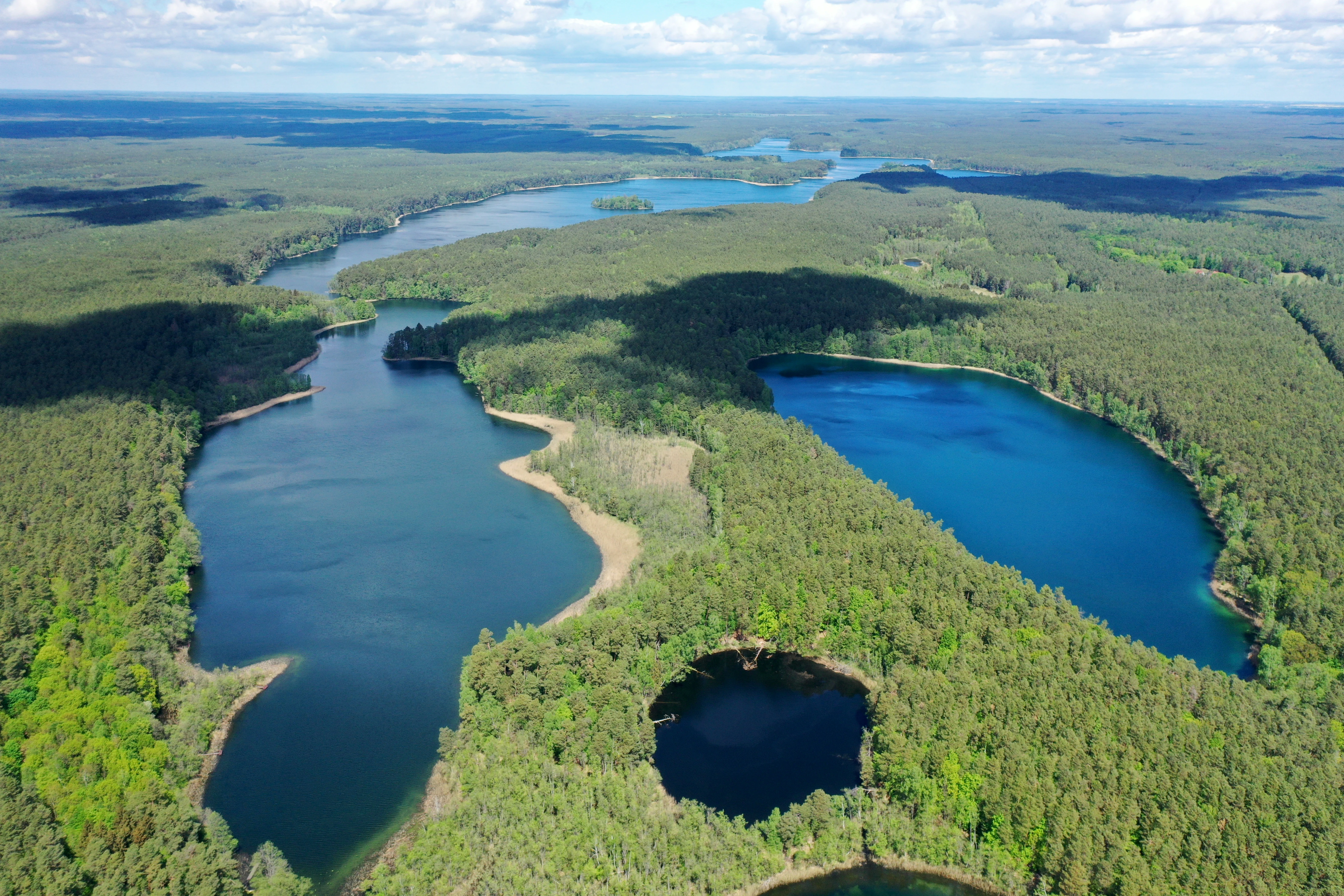
Aerial view of Lake Czarne and Lake Ostrowite
Aerial view looking north over Lake Ostrowite and Lake Czarne.

Drawieński National Park history and protected-area timeline

Drawieński National Park was formally established on 1 May 1990 through a Polish legal act, becoming one of the country's later additions to its national park system. At the moment of creation it covered about 8,690 hectares, drawn from the existing state forest lands of the wider Drawska Forest complex. The new park pulled together exceptionally valuable forest, lake and river landscapes that had long been recognized for their ecological importance but lacked the highest tier of protection.

Following its establishment, the park gradually expanded through land acquisitions and adjustments, reaching roughly 11,535 hectares in total area. The land belongs to the Polish state and is held in perpetual use by the park administration, with the bulk of the territory split between the Lubuskie and Zachodniopomorskie provinces and a smaller portion in Wielkopolskie.

Around the same period, a buffer zone of more than 35,000 hectares was delineated around the park to absorb external pressures and maintain ecological continuity. Multiple nature reserves were later designated in this buffer zone to protect peatlands, spring mires and old-growth forest fragments.

Across its history, the park has also accumulated a notable cultural layer. The remains of a 19th-century eel-trapping facility on the Płociczna river hint at the long-standing human use of the region's waters, and the park's educational trail network, established in the years after 1990, reflects a strong public-engagement tradition. Plans to extend the park further south and west, incorporating additional sandr terrain, beech forests, river valleys and peatland complexes, have been under discussion for many years, signaling that its protected footprint may continue to grow.

Drawieński National Park landscape and geographic character

Drawieński National Park sits on the Równina Drawska, a postglacial lowland plain in northwestern Poland formed by the ice sheet that once covered much of northern Europe. Rather than dramatic relief, the landscape is characterized by subtle but persistent glacial features: low moraine ridges, undulating outwash plains, kettle depressions filled with water or peat, and wide sandur surfaces. The result is a quietly rolling terrain where views open and close rapidly between ridges, forest edges and water.

The park's rivers are central to its landscape identity. The Drawa cuts a winding, sometimes gorge-like valley through glacial deposits, while the smaller Płociczna threads through forest and meadow in a similarly meandering course. Together, the rivers produce steep little banks, sand spits, marshy floodplains, and abandoned channels that diversify the forest environment.

Lakes complete the hydrological picture. Roughly twenty lake basins are scattered across the park, ranging from small, darkly stained humic pools to larger open waters. Lake Ostrowite, the largest, anchors the central part of the park and is surrounded by islands and peninsulas of conservation interest. Lake Czarnka, with its distinctive dark water chemistry, is considered unique at the national scale and adds a special ecological tone to the park's lake chain.

Forests mask much of the underlying topography. With woodland covering about 83 percent of the park, continuous forest tracts dominate the visual experience, and the eye is rarely far from a stand of beech, oak-beech or pine. Peatland fringes along rivers and lake margins interrupt the wooded view with open, moist ground, and the contrast between sheltering forest and bright, open water is a recurring feature of the park's character.
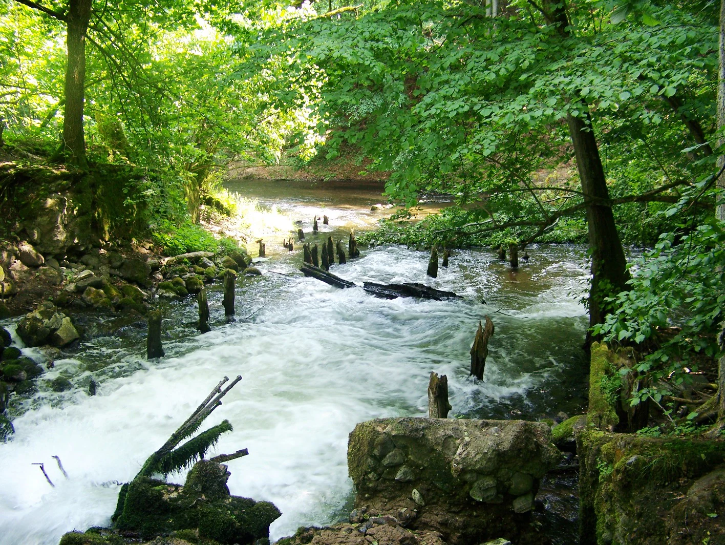
Ruins of the charcoal kiln
Ruins of an old charcoal kiln located on the Plociczna River in Drawienski National Park

Drawieński National Park ecosystems, habitats, and plant life

Ecologically, Drawieński National Park is a lowland forest-lake-river complex of unusually high habitat diversity. The combination of extensive forest, a dense network of rivers and lakes, and significant peatland and bog patches creates overlapping ecological zones within a relatively small area. Forests dominate the landscape and define its broader ecological character, while aquatic and semi-aquatic systems add layers of biological richness.

Beech and oak-beech woodlands form the signature forest type, with mature stands of beech giving way to mixed deciduous communities where oak plays a stronger role. Pine forests, sometimes with admixtures of spruce and birch, occupy drier sandy outwash and sandur soils. Along rivers and around lakes, alder carrs, damp oak-hornbeam forests and bog woodland fringe the waters, supporting moisture-loving plants such as marsh marigold communities, sedges, ferns and bryophytes.

Around 900 plant species have been recorded in the park, an unusually rich figure for a lowland Polish national park. The flora includes several species of conservation interest, including northern chamaedaphne, small-leaved cranberry, cladium, martagon lily, wild service tree, orchids, sundews and other bog and woodland specialists. Peatlands and transitional mires host many of the most sensitive plant communities.

The park's mosaic of habitats supports equally varied fauna, though that is covered in a separate wildlife section. From a habitat standpoint, the key point is the interconnection of forest, peatland, river and lake systems, which allows species associated with very different environments to coexist within a single protected area.
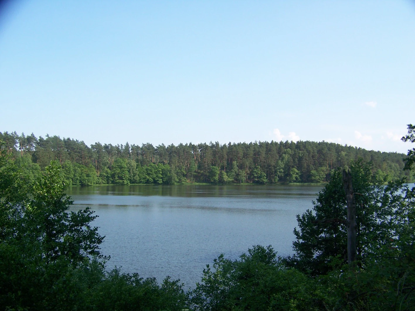
Ostrowieckie Lake view
View of the northeastern shore of Ostrowieckie Lake from the Sitieński Canal, showing the Klota Ostrowieckie area in Drawieński National Park

Drawieński National Park wildlife and species highlights

The wildlife profile of Drawieński National Park is broad and reflects the park's varied mix of forests, rivers, lakes and peatlands. Mammals are well represented, with roughly 50 recorded species. Large ungulates such as red deer and roe deer are common throughout the forested areas, alongside wild boar, which thrives in the park's mix of mast-rich beech-oak woodland and damp ground. Beaver and otter are characteristic of the park's waterways, with the otter serving as an unofficial symbol species of the park and indicating the relative health of its river systems.

Larger carnivores are also present, including gray wolf, which moves through the forests as part of its broader regional range, and several non-native species that have expanded across Poland in recent decades, such as raccoon dog and raccoon, as well as American mink. Bats are documented across the park, using old trees, buildings and other sheltered sites.

Birdlife is one of the park's strongest ecological features, with around 130 breeding species recorded. The forests and lake shores together support a remarkable range of birds, including white-tailed eagle and osprey, both of which fish in the park's lakes and rivers. Eagle owl occurs in mature woodland, while black stork, gray heron, common crane and the often-overlooked corncrake haunt quieter wet and forested habitats. Ducks such as common goldeneye and goosander use the lakes and rivers, while smaller species including gray wagtail and the stream-loving dipper follow the fast-flowing stretches of the Drawa and Płociczna. Kingfisher is among the visually striking species associated with the riverbanks.

Fish diversity in the rivers and lakes is considerable, with around 30 species recorded. The park's clean, well-oxygenated waters are home to migratory sea trout, lake-resident trout, brown trout, grayling, white-finned gudgeon, vimba bream, coregonus species and other salmonids and associated species. In shallower and warmer waters, common cyprinids and perch-family fish also occur, contributing to a balanced freshwater fish community.

Invertebrate life is rich as well, encompassing dragonflies along the rivers, butterflies in open forest rides, and an array of beetles and other insects tied to old trees, dead wood and bog habitats. This invertebrate diversity, often overlooked, is one of the foundations of the park's broader food web.

Drawieński National Park conservation status and protection priorities

Drawieński National Park's conservation importance lies in its unusually intact combination of lowland forest, lake, river and peatland ecosystems, much of which has remained comparatively undisturbed by intensive land use. The park contributes to the protection of large, well-connected forest tracts within the broader Drawska Forest complex, which is itself one of the largest forested regions of western Poland.

Strict protection reserves form the backbone of in-park conservation. Twelve strict nature reserves cover the most valuable fragments of the park, totalling several thousand hectares, and limit human intervention to the strictest regime allowed under Polish conservation law. Active and landscape-level protection zones make up the rest of the park area, allowing managed forestry, habitat work and visitor use under controlled conditions.

Outside the park, a large buffer zone extends conservation influence across hundreds of square kilometers of surrounding forests, peatlands and farmland. Five additional nature reserves sit within this buffer, protecting specific features such as peat bogs and old-growth forest stands. These outlying reserves both shield the park from external pressures and preserve ecological features that complement the habitats inside the park itself.

The park safeguards important populations of large mammals, large raptors, salmonid fishes and bog-specialist plants, contributing to wider conservation efforts for these species in Poland and central Europe. Its otter population, in particular, is considered a strong indicator of river ecosystem health.

Plans under discussion to substantially expand the park would further strengthen these conservation roles by adding moraine forests, additional peatlands and the lower Drawa valley to the strictly protected estate, deepening the park's significance as a refugium of lowland wilderness in an otherwise heavily altered part of Europe.

Drawieński National Park cultural meaning and human context

Although the park today reads as a wilderness area, the land has supported human activity for centuries, mostly tied to the rivers and lakes. The remains of a 19th-century eel-trapping installation on the Płociczna river, preserved within the park, are reminders that fish harvesting was once an important part of the local economy, taking advantage of migratory eels ascending from the Baltic.

Small villages, forest settlements and historical estates sit around the park's edges, and the town of Drawno, the park's administrative seat, has long served as a local hub for forestry and rural life in this part of western Poland. The region has also seen shifting borders and populations over the centuries, a pattern common across much of northwestern Poland, and the cultural landscape around the park mixes Polish, German and earlier regional influences.

Traditional low-intensity forest use, including timber harvesting, charcoal burning and small-scale grazing, shaped the surrounding woodlands for generations. Although intensive forestry is now excluded from strict protection zones, this longer history of human interaction with the forest is still legible in place names, scattered ruins and the structure of older forest stands.

In recent decades, a strong culture of nature education has taken root. Educational trails, interpretive paths and visitor programs within the park help connect local communities and outside visitors to the ecological and historical value of the area, making the park both a conservation area and a place of regional identity.

Top sights and standout views in Drawieński National Park

Drawieński National Park's highlights revolve around the meeting of woodland, water and glacial landforms. The vast beech and oak-beech forests are a defining strength, particularly remarkable for their extent in a lowland setting. The park's lake chain, anchored by Lake Ostrowite and including the unique Lake Czarnka, adds striking scenery and ecological diversity.

The river valleys of the Drawa and Płociczna provide both visual highlights and important ecological corridors, supporting salmonid fish, otter, and breeding birds such as kingfisher and dipper. The park's strict protection reserves, including forest, lake and peatland reserves, anchor its conservation identity and protect its most sensitive features.

For visitors, the highlight is the atmosphere: a sense of being inside a continuous, mature lowland forest, broken occasionally by lake views, river rapids, peatland openings and the silence of strictly protected ground. The park offers a gentle but distinctive form of wilderness that is uncommon in western Poland.

Best time to visit Drawieński National Park

The park's character changes meaningfully with the seasons. Late spring and early summer bring fresh green foliage, the most active bird period, and the best conditions for hearing species such as corncrake, common crane and various warblers in wetland edges and meadows. This is also when many forest plants, including orchids and lily species, are at their most visible.

Summer offers the warmest conditions for canoeing on the Drawa and Płociczna, swimming in the lakes, and following the park's educational trails. Lakeside and riverside scenes are at their most active, and dragonflies, butterflies and forest insects add to the lively atmosphere. Forest interiors remain cool and shaded thanks to the dense canopy.

Autumn transforms the park into a landscape of warm beech and oak color, with mushroom-rich forest floors and an influx of migratory birds, waterfowl and raptors. Visibility often improves as leaves thin, and the lakes reflect the changing forest palette. Winter brings snow, frozen or partially frozen lake surfaces, and quiet forest scenes ideal for tracking and observing animal signs, though access to certain trails and waterways may be limited by seasonal conditions.

Overall, late spring through early autumn offers the broadest experience for general visitors, while autumn and winter appeal to those interested in migration, quieter scenery and atmospheric forest landscapes.

Monthly climate preview

Long-term representative measurements illustrating the annual weather rhythm across twelve months

Drawieński Park Narodowy Climate Normals, Average Temperature and Precipitation Patterns

Representative coordinate records show average temperatures ranging from winter sub-zero minimums to summer maximums exceeding thirty degrees, paired with measured monthly precipitation rates. Detailed long-term data provides complete monthly breakdowns of thermal ranges and precipitation patterns for deeper geographic analysis.
Annual mean9 °C
-2 °C19 °C
Jan-2°
Feb
Mar
Apr
May14°
Jun17°
Jul19°
Aug19°
Sep14°
Oct
Nov
Dec
Warmest month
July

19.2 °C

Coolest month
January

-1.8 °C

Wettest month
July

2.5 mm/day

Driest month
April

1.1 mm/day

Park location guide

Geography guide, regional context, and park location map for Drawieński National Park

Drawieński National Park park geography, regions, and map view in Poland

Understand where Drawieński National Park sits in Poland through a broader geographic reading of the surrounding landscape, nearby location context, and its mapped position within the national park landscape.

How Drawieński National Park fits into Poland

Poland, officially the Republic of Poland, is a Central European country spanning from the Baltic Sea in the north to the Carpathian Mountains in the south. It borders Germany, Czech Republic, Slovakia, Ukraine, Belarus, Lithuania, and Kaliningrad Oblast. The country has a temperate climate, diverse landscapes, and is known for its rich history, cultural heritage, and strong economic position within the EU.

Wider geography shaping Drawieński National Park in Poland

Poland occupies 312,696 km2 in Central Europe, extending from the Baltic Sea coast in the north to the Sudetes and Carpathian Mountains in the south. It borders Germany to the west, Czech Republic and Slovakia to the south, Ukraine and Belarus to the east, and Lithuania and Kaliningrad Oblast to the northeast. The landscape includes lowland plains, uplands, and mountain ranges.

Map view of Drawieński National Park

Use this park location map to pinpoint Drawieński National Park in Poland, understand its exact geographic position, and read its mapped placement within the surrounding landscape more clearly.

Pigeon | © OpenStreetMap contributors
Natural feature types

Browse the Full Collection of Natural Features in Drawieński Park Narodowy

Continue your geographic discovery by examining the named landforms and water systems of Drawieński Park Narodowy. MoriAtlas provides a structured way to identify the diverse terrain, river valleys, and glacial lake basins that define this protected territory in western Poland.

Visual reference guide to postglacial terrain, beech woodlands, and river habitats.

Drawieński Park Narodowy Photos and Landscape Scenery

Examine professional field photography documenting the dense lake networks, meandering river valleys, and vast lowland forest tracts of Drawieński Park Narodowy. Visual records reveal the subtle glacial topography and protected habitats that define the landscape identity of this western Polish sanctuary.

Aerial view of Lake Czarne and Lake Ostrowite

Dragonfly in Drawienski National Park

Ruins of the charcoal kiln

Ostrowieckie Lake view

Park atlas

Compare regional park geography, postglacial lowland terrain, and connected protected landscapes.

Explore Other Parks Near Drawieński Park Narodowy and Surrounding Protected Areas

Browsing nearby national parks and regional protected areas extends the geographic context established at Drawieński Park Narodowy. Comparing adjacent woodland and river ecosystems reveals broader patterns across the surrounding postglacial landscape.
Watercolor painting depicting a river flowing through a forested landscape with hills in the background
National parkWest Pomeranian Voivodeship
Park boundaries overlap#1 closest

West

Drawa National Park: Protected Landscape and River Geography in West Pomeranian Voivodeship

Explore Poland's unique lowland river and ancient forest protected area.

Drawa National Park stands as a vital protected area within West Pomeranian Voivodeship, Poland, celebrated for its exceptional natural geography. The park's core feature is the Drawa River, which carves a distinctive path with fast-flowing currents and deep valleys, presenting a landscape more akin to mountain streams than typical lowland waterways. This area protects one of Poland's most valuable lowland river corridors, featuring ancient beech and oak forests, the rare meromictic Lake Czarne, and diverse wetland habitats. MoriAtlas facilitates structured exploration of Drawa National Park's mapped terrain and protected landscape identity.

Area
115.36 km²
Established
1990
IUCN
II
Visitors
27K annual
Nature reserveZachodniopomorskie
About 4.2 km away#2 closest

Northeast

Mszary Tuczyńskie Nature Reserve: Protected Peatland and Grassland Landscape in Poland

A rare habitat mosaic within the Zachodniopomorskie protected region

Mszary Tuczyńskie protects a highly varied mosaic of wetland, meadow, and xerothermic grassland habitats concentrated within a small area near Lake Tuczno. This nature reserve functions as a critical component of the regional conservation network, offering a concentrated look at spring fed calcareous peatlands and specialized orchid populations common to this specific lowland geography.

Area
0.072 km²
Established
1988
Relief
Lowland
Scope
Terrestrial
Nature reserveZachodniopomorskie Voivodeship
About 9.1 km away#3 closest

East

Bagno Raczyk Nature Reserve: Mapped Wetlands and Protected Habitats of Zachodniopomorskie

A diverse riparian landscape in the Pojezierze Wałeckie region

Bagno Raczyk Nature Reserve encompasses a pristine sequence of reedbeds, sedge marshes, and alder forest swamps at the mouth of the Cieszynka River. This compact protected area demonstrates the ecological value of glacial lake fringes in northwestern Poland, offering significant insight into the water-dominated terrain of the Wałcz County region.

Area
0.342 km²
Established
2011
Protected areaWest Pomeranian Voivodeship
16 km away#4 closest

Northwest

Ostoja Ińska Protected Area: Geographic Context and Landscape Features in West Pomeranian Voivodeship

Postglacial moraine ridges and wetland mosaic exploration

Ostoja Ińska is a major bird protection sanctuary in northwestern Poland, renowned for its postglacial mosaic of lakes, bogs and forests. Spanning the Iński Landscape Park, the area offers a unique view into the undulating topography of the Pomeranian lake district and its vital role in regional avian conservation.

Area
877.109 km²
Established
2004
Relief
Upland
Climate
Temperate
Nature reserveZachodniopomorskie Voivodeship
About 18 km away#5 closest

East

Rezerwat przyrody Mokradła koło Leśniczówki Łowiska: Protected Landscapes and Map Geography

A nature reserve located in the West Pomeranian Voivodeship

Located in the heart of the Wałeckie Lake District, this nature reserve is a concentration of transitional bogs and dystrophic lakes. The site remains a critical node in the Drawa River basin, serving as a protected landscape for rare bog mosses and peat forming processes framed by mature pine stands. Explore the mapped boundaries and natural terrain of this unique ecological refuge.

Area
1.018 km²
Established
2011
Relief
Lowland
Climate
Temperate
Nature reserveLubusz Voivodeship
About 23 km away#6 closest

Southwest

Rezerwat przyrody Mszar Przygiełkowy, Długie im. Huberta Jurczyszyna Nature Reserve

Protected peatland and raised bog landscape in Lubusz Voivodeship

This nature reserve in western Poland serves as a crucial reference site for peatland ecology, showcasing diverse raised and transitional bog habitats. Learn about the reserve's protected botanical landscape, the role of Rhynchospora alba in its ecosystem, and its regional position within the wider forest network of the Lubusz Voivodeship.

Area
0.078 km²
Established
2009
Relief
Lowland
Scope
Terrestrial
Nature reserveLubusz Voivodeship
About 25 km away#7 closest

Southwest

Rezerwat przyrody Mszar Rosiczkowy koło Rokitna: Protected Peatland and Bog Geography

Nature reserve terrain and regional ecological context

This protected area in the Lubusz Voivodeship features a diverse mosaic of raised bog sub habitats. The site is characterized by carnivorous sundew populations and open Scots pine stands rooted in acidic peat, offering a concentrated look at the unique post glacial landscape features found throughout western Poland.

Area
0.034 km²
Established
2009
Water
Major water bodies
Nature reserveZachodniopomorskie
About 29 km away#8 closest

West

Dęby Sądowskie Nature Reserve: Ancient Woodland and Protected Geography in Poland

A rare old-growth forest refuge in the West Pomeranian landscape

Discover the ecological value of Dęby Sądowskie, a vital nature reserve in Poland known for its monumental pedunculate oaks and intact subatlantic forest communities. Located in the Choszczeńskie Lake District, this protected site serves as a crucial fragment of natural heritage within an intensively managed regional agricultural mosaic.

Area
0.031 km²
Established
1985
Relief
Lowland
Scope
Terrestrial

Common questions about visiting, size, designation, and location context for Drawieński National Park

Drawieński National Park FAQs for park facts, access, geography, and protected area context

Find quick answers about Drawieński National Park, including protected-area facts, park geography, trail and visitor context, and how the park fits into its surrounding country and regional landscape.
MoriAtlas Explorer

Continue Your Protected Areas Search Across the Global Atlas

Deepen your exploration by continuing the structured search for national parks and protected areas worldwide. Utilize the comprehensive filtering capabilities to compare different conservation landscapes and refine your understanding of global park geography. Discover more about the distribution and characteristics of protected natural areas.

Global natural geography