

Mori Atlas logo
Wildlife reserveEast Fork High Rock Canyon Wilderness

Examine the rugged canyon topography and basalt-defined terrain of this Great Basin wilderness.

East Fork High Rock Canyon Wilderness: A Protected High Desert Landscape in Nevada

East Fork High Rock Canyon Wilderness represents a remote, protected stretch of arid plateau and dramatic canyon corridors in northwestern Nevada. This wilderness area preserves a significant portion of the volcanic high desert that borders the Black Rock region, providing an essential buffer of quiet, undisturbed terrain within the Great Basin. Map the boundaries of this basalt-sculpted landscape and understand its role as a key geographic anchor in the wider regional network of federally protected lands.

Bureau of Land ManagementWilderness AreaHigh DesertCanyon CountryBlack Rock RegionGreat Basin

East Fork High Rock Canyon Wilderness

Wildlife reserve

Park overview

Structured park overview, official facts, and landscape profile for East Fork High Rock Canyon Wilderness

East Fork High Rock Canyon Wilderness park facts, protected area profile, and essential visitor context

Review the core facts for East Fork High Rock Canyon Wilderness, including designation, size, terrain, visitor scale, habitats, and operating context in one park-focused overview.

About East Fork High Rock Canyon Wilderness

East Fork High Rock Canyon Wilderness is a federally designated Wilderness Area in northwestern Nevada, situated within the broader Black Rock Desert landscape that defines the far northern edge of the state. Although it is relatively small and little known compared to the more prominent national parks of the American West, it plays an important role in the regional conservation framework around the Black Rock-High Rock area.

The wilderness falls under the jurisdiction of the Bureau of Land Management, which oversees much of the public land in Nevada. Within the BLM's land management system, this wilderness sits adjacent to and is closely associated with the Black Rock-High Rock NCA, a National Conservation Area that links a series of protected units around the Black Rock Playa and the canyons draining into it. East Fork High Rock Canyon Wilderness contributes a strict-protection element within that broader managed landscape.

Geographically, the area lies on the northeast side of High Rock Canyon, a major canyon feature that channels water and vehicle routes down toward the desert floor. The wilderness itself does not include the high-use 4x4 trail that runs through the floor of High Rock Canyon, nor the side trail that climbs toward the Yellow Hills area. This deliberate exclusion separates the most heavily traveled portions of the surrounding region from the protected zone, leaving the wilderness as a quieter, less disturbed portion of an otherwise active recreational landscape.

In character, the area is classic northwestern Nevada high desert: dry, sparsely vegetated, and shaped by volcanic geology and long-term erosion. Elevations in the area are in the middle range for the region, and the surrounding environment reflects the Great Basin's mix of basalt flows, sage-steppe vegetation, and dramatic canyon cuts. The wilderness contributes to the ecological integrity of the broader Black Rock region by protecting a section of canyon and upland from vehicle use and development.

Quick facts and research context for East Fork High Rock Canyon Wilderness

East Fork High Rock Canyon Wilderness is a U.S. Wilderness Area located in the Black Rock Desert region of Nevada, United States. The BLM manages it, and it was officially established in 2000 as part of the broader federal wilderness program.

Geographically, the wilderness lies on the northeast side of High Rock Canyon, away from the main off-highway vehicle routes that run through the canyon itself. The surrounding terrain is high elevation Great Basin desert, and the area is administratively connected to the larger Black Rock-High Rock NCA landscape complex.

Protection and recognition

Documented terrestrial protection scope, establishment year, and management details

East Fork High Rock Canyon Wilderness Protection Status and Designation Records

East Fork High Rock Canyon Wilderness features a documented terrestrial protection scope established in the year 2000. Structured conservation records provide clear insight into the official designation history and management framework.

Protection details

Protection scope
Terrestrial
Designated year
2000
Transboundary protection
No
Park context

Deeper park guide and search-rich context for East Fork High Rock Canyon Wilderness

East Fork High Rock Canyon Wilderness history, landscape, wildlife, and travel context

Explore East Fork High Rock Canyon Wilderness through its history, landscape character, ecosystems, wildlife, conservation priorities, cultural context, and seasonal travel timing in a structured park guide built for atlas discovery and search intent.

Why East Fork High Rock Canyon Wilderness stands out

The wilderness is best known for protecting the rugged northeast rim of High Rock Canyon, a striking geological corridor at the edge of the Black Rock Desert in northwestern Nevada. Its defining feature is the deep canyon system of High Rock and the arid, basalt-influenced high desert that surrounds it. Because the wilderness lies just off the main 4x4 routes through High Rock Canyon and the Yellow Hills, it represents the quieter, more strictly protected side of an otherwise heavily traveled off-road recreation area. Its identity is tied as much to absence of development and to unbroken desert vistas as to any single landmark.

East Fork High Rock Canyon Wilderness history and protected-area timeline

East Fork High Rock Canyon Wilderness was officially established in 2000, taking its place among the additions to the U.S. National Wilderness Preservation System that strengthened BLM-managed conservation in the late twentieth and early twenty-first centuries. Its creation was tied to the evolving approach that the Bureau of Land Management and Congress applied to the Black Rock-High Rock region, balancing the area's strong off-highway vehicle tradition with the need to set aside wilderness-quality lands in a more protective status.

The wilderness was designated around the same period that the broader Black Rock-High Rock landscape was reorganized into a National Conservation Area framework, which also includes a set of related wilderness units. The aim of these designations was to formalize the varying levels of protection within a single large landscape, with the conservation area permitting active multiple-use management and the wilderness layers within it receiving the highest level of statutory protection.

East Fork High Rock Canyon Wilderness landscape and geographic character

The landscape of East Fork High Rock Canyon Wilderness is defined by the rugged upper side of High Rock Canyon and the surrounding high desert plateau country of northwestern Nevada. The canyon itself is a major erosional feature cutting through basalt and older volcanic terrain as it descends toward the Black Rock Desert floor to the south and west.

Within the wilderness, the topography is dominated by steep canyon edges, dry side drainages, and expanses of open, rolling high desert. The vegetation is typical of the Great Basin, with sparse shrub cover adapted to low precipitation and extreme temperature swings. Because the wilderness sits at mid-range elevations for the region, it bridges the lower desert flats that surround it and the higher rocky uplands that lead toward the broader volcanic terrain of the area.

The defining visual quality of the area is the sense of open space and exposure, with long sightlines across arid terrain and dramatic drops where the land falls into High Rock Canyon. This is the kind of landscape that emphasizes sky, distance, and the stark interplay between dark volcanic rock and pale desert soils.

East Fork High Rock Canyon Wilderness ecosystems, habitats, and plant life

The natural character of East Fork High Rock Canyon Wilderness is shaped by the arid conditions of northwestern Nevada's Great Basin desert. Vegetation is sparse and adapted to drought, dominated by cold-hardy and drought-tolerant shrub communities typical of the Black Rock region's ecological zone.

Habitats within the wilderness include dry upland slopes, canyon-edge environments, and the fringes of broader desert flats. These support the plant and animal communities characteristic of Great Basin high desert, including small mammals, reptiles, and birdlife adapted to sparse cover and harsh seasonal conditions. The wilderness also contributes to the regional ecological network by maintaining a less disturbed refuge within a landscape where off-highway vehicle use is otherwise prominent.

The ecological value of the area is closely tied to its elevation, its position relative to the canyon drainage, and its distance from the most heavily used routes. By keeping a portion of the High Rock Canyon landscape outside the busiest recreational corridors, the wilderness preserves a more intact version of the regional desert ecosystem.

East Fork High Rock Canyon Wilderness wildlife and species highlights

Wildlife in and around East Fork High Rock Canyon Wilderness follows the patterns of the broader Black Rock region. Common inhabitants of Great Basin high desert environments, including small mammals, reptiles, and characteristic bird species of arid northwestern Nevada, are expected to occupy the area.

The wilderness contributes to the regional habitat network by providing a quieter, less disturbed section of canyon and upland adjacent to more heavily traveled corridors. While it does not have a documented charismatic megafauna profile of its own, its ecological function is rooted in supporting the smaller-scale species communities and seasonal wildlife patterns that depend on undisturbed desert terrain in this part of the Great Basin.

East Fork High Rock Canyon Wilderness conservation status and protection priorities

The primary conservation value of East Fork High Rock Canyon Wilderness lies in its designation as a federally protected Wilderness Area, the highest level of statutory protection available within the BLM-managed National Wilderness Preservation System. By being shielded from mechanized use and development, it retains a more intact version of the surrounding high desert landscape.

Within the broader Black Rock-High Rock landscape framework, the wilderness plays a complementary role alongside the surrounding National Conservation Area. The conservation area allows active multiple-use management, including regulated off-highway vehicle recreation, while the wilderness preserves a quieter zone set aside for wilderness values such as solitude, naturalness, and ecological integrity.

Together with neighboring wilderness units in the same landscape complex, East Fork High Rock Canyon contributes to a layered approach to land protection in this part of Nevada, ensuring that some portion of the regional environment is maintained in a more natural condition for the long term.

East Fork High Rock Canyon Wilderness cultural meaning and human context

The broader High Rock Canyon and Black Rock region has a long human history tied to emigrant trails crossing northwestern Nevada toward California. The area is historically associated with the overland migration routes of the mid-nineteenth century and with later patterns of ranching, mining, and recreational travel.

Although the wilderness itself does not encompass the main trail or modern off-road routes, it sits within a landscape that carries strong cultural resonance in the regional imagination of the American West. Its protected status reflects a contemporary land ethic that seeks to balance that cultural and recreational heritage with the preservation of representative stretches of the original high desert environment.

Top sights and standout views in East Fork High Rock Canyon Wilderness

East Fork High Rock Canyon Wilderness is distinguished by its position on the rugged northeast side of High Rock Canyon, away from the most heavily used off-road routes of the surrounding Black Rock area. Its highlights include the dramatic canyon-edge terrain, the unbroken high desert vistas, and the strict wilderness protection that sets it apart within the larger Black Rock-High Rock landscape.

The area offers a sense of solitude and naturalness that contrasts with the busier recreational corridors just outside its boundaries, making it a quiet anchor within one of Nevada's most recognized multi-use conservation landscapes.

Best time to visit East Fork High Rock Canyon Wilderness

Climate and seasonality in the Black Rock region follow typical Great Basin high desert patterns, with hot, dry summers and cold winters. Spring and fall tend to offer the most temperate conditions for experiencing the landscape, when temperatures are moderate and the desert environment is more accessible without the extremes of mid-summer heat or winter cold.

Monthly climate preview

Long term average monthly temperature and precipitation patterns recorded across twelve months

East Fork High Rock Canyon Wilderness Climate Normals and Temperature Rhythms

Historical data records long term monthly temperature and precipitation averages measured at a representative coordinate within East Fork High Rock Canyon Wilderness. Detailed month by month climate normals illustrate the full annual cycle of thermal variation and moisture distribution across the protected landscape.
Annual mean8 °C
-3 °C21 °C
Jan-3°
Feb-1°
Mar
Apr
May11°
Jun16°
Jul21°
Aug20°
Sep15°
Oct
Nov
Dec-3°
Warmest month
July

21.4 °C

Coolest month
December

-2.9 °C

Wettest month
May

1 mm/day

Driest month
August

0.2 mm/day

Park location guide

Geography guide, regional context, and park location map for East Fork High Rock Canyon Wilderness

East Fork High Rock Canyon Wilderness park geography, regions, and map view in United States of America

Understand where East Fork High Rock Canyon Wilderness sits in United States of America through a broader geographic reading of the surrounding landscape, nearby location context, and its mapped position within the national park landscape.

How East Fork High Rock Canyon Wilderness fits into United States of America

The United States of America is a federal presidential republic and one of the world's largest countries by area and population. It consists of 50 states across a vast territory spanning multiple time zones, with its capital in Washington, D.C. and largest city in New York City. The nation has a diverse economy, influential political system, and significant cultural and military presence globally.

Wider geography shaping East Fork High Rock Canyon Wilderness in United States of America

The United States occupies a vast territory in North America, bordered by Canada to the north and Mexico to the south. The 48 contiguous states stretch from the Atlantic to the Pacific Ocean, while Alaska occupies the northwestern region and Hawaii is an archipelago in the Pacific. The country encompasses diverse terrain including the Rocky Mountains, Appalachian Mountains, Great Plains, and extensive river systems.

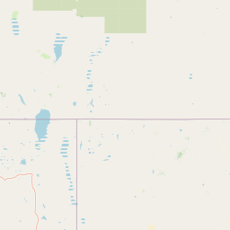
Map view of East Fork High Rock Canyon Wilderness

Use this park location map to pinpoint East Fork High Rock Canyon Wilderness in United States of America, understand its exact geographic position, and read its mapped placement within the surrounding landscape more clearly.

Pigeon | © OpenStreetMap contributors

Location context for East Fork High Rock Canyon Wilderness

Nevada
Recorded earthquake history

Review Historical Earthquake Records for East Fork High Rock Canyon Wilderness

Examine our cataloged archive of seismic events mapped in relation to the wilderness boundaries. Review event data including magnitude and epicentre distance within the broader MoriAtlas geographic database for this region.

East Fork High Rock Canyon Wilderness Earthquakes

Catalogued events

320 events

Strongest magnitude

Magnitude 4.7

Most recent event

Jul 18, 2025

This history includes earthquakes recorded inside the park or within 50 km of its borders

Park atlas

Compare connected protected areas and regional wilderness zones across the Great Basin.

Explore Parks Near East Fork High Rock Canyon Wilderness and Surrounding Desert Landscapes

Discover protected areas and rugged canyon landscapes adjacent to East Fork High Rock Canyon Wilderness. Comparing these regional desert reserves reveals the broader volcanic terrain and high plateau geography shaping northwestern Nevada.
Protected areaNevada
1.5 km away#1 closest

South

Little High Rock Canyon Wilderness: Mapping the High Desert Protected Landscapes of Nevada

A rugged canyon environment within the expansive Great Basin desert

Explore the distinct geography of Little High Rock Canyon Wilderness, where sharp basalt walls and sheltered canyons break the wide sagebrush expanse of northern Nevada. This protected area serves as a vital component of the High Rock country, offering a compact yet significant look at the high desert terrain and historic landscape features defining this remote portion of the Great Basin.

Established
2000
Relief
Upland
Climate
Arid
Access
Remote access
Protected landscapeCalifornia
59 km away#2 closest

West

Modoc National Forest: Protected Landscape and Warner Mountains Geography

High desert volcanic terrain in northeastern California

Modoc National Forest encompasses a massive expanse of volcanic plateaus and rugged mountain ridges in the northeastern corner of California. This protected area offers significant geographic variety, transitioning from arid sagebrush basins to lush, high-elevation conifer forests. It serves as a vital natural landscape, home to the South Warner Wilderness and large stands of old-growth timber, reflecting the unique geologic history of the regional lava flows.

Area
6,695.09 km²
Established
1904
Relief
Mountain
Access
Moderate access
A watercolor painting showing soft green hills, distant pink-hued mountains, and a pale blue lake in a serene, stylized landscape.
Protected landscapeNevada
128 km away#3 closest

Southeast

Humboldt, Toiyabe National Forest: Protected Landscape and Regional Mountain Geography

A vast network of Nevada mountain ranges and alpine wilderness

Humboldt, Toiyabe National Forest serves as a defining public land entity across Nevada and eastern California. As the largest national forest in the contiguous United States, it preserves a striking collection of isolated mountain ranges, including the Ruby Mountains and the rugged Jarbidge wilderness, within a broader basin-and-range landscape. Examine the boundaries and terrain that characterize this complex, high-desert ecosystem.

Area
25,454 km²
Established
1908
Relief
Mountain
Access
Easy access
A wide watercolor illustration showing a calm body of water surrounded by green hills, conifer trees, and reeds in the foreground.
Protected landscapeCalifornia
129 km away#4 closest

Southwest

Lassen National Forest: Mapped Geography and Protected Landscapes of Northern California

Volcanic terrain and expansive old growth ecosystems

Lassen National Forest represents a vast protected landscape in Northern California, defined by its severe volcanic geology and resilient conifer forests. This atlas entry provides essential geographic context regarding the forest boundaries, the volcanic rim of Mount Tehama, and the intricate river systems shaping the region. Explore the terrain, from accessible lava tubes to the wilderness areas preserved within this significant mountain corridor.

Area
4,331.53 km²
Established
1905
Relief
Mountain
Climate
Temperate
Wildlife reserveOregon
153 km away#5 closest

Northwest

Gearhart Mountain Wilderness: Protected Mountain Geography and Forest Atlas

High elevation terrain in the Fremont Winema National Forest

Spanning the border between Lake and Klamath counties, Gearhart Mountain Wilderness stands as a testament to the diverse mountain geography of south-central Oregon. The area features a complex mosaic of white fir, ponderosa pine, and pure lodgepole stands, set within a glacially sculpted landscape of cirques and ridges. This protected refuge serves as a key headwater source and mountain sanctuary, offering expansive vistas that span from the southern Cascades to the far horizon of the Oregon desert landscape.

Area
92.36 km²
Established
1943
IUCN
Ib
Relief
Mountain
Protected landscapeCalifornia
153 km away#6 closest

Southwest

Plumas National Forest: Mapped Geography and Protected Landscape Features in California

Exploring the Sierra Nevada watershed and wilderness terrain

Plumas National Forest serves as a critical protected landscape in northern California, anchoring the headwaters of the Feather River system. This atlas entry details the forest's rugged canyons, high elevation mountain lakes, and significant old growth conifer stands that define its role within the northern Sierra Nevada ecosystem.

Area
4,640 km²
Established
1907
Relief
Mountain
Climate
Mediterranean
A soft watercolor painting depicting a serene landscape with gentle green hills, a small forest, and a calm lake at sunrise or sunset.
Protected landscapeCalifornia
173 km away#7 closest

West

Shasta, Trinity National Forest: Mapping the Protected Landscapes of Northern California

Volcanic peaks, expansive reservoirs, and rugged mountain wilderness

Spanning over two million acres, Shasta, Trinity National Forest represents a major protected landscape in Northern California. The geography includes the iconic Mount Shasta volcano and the complex shoreline of Shasta Lake, while hosting expansive wilderness areas and diverse terrain ranging from oak-forested foothills to alpine meadows.

Area
8,942.87 km²
Established
1954
Relief
Mountain
Climate
Temperate
National parkCalifornia
181 km away#8 closest

Southwest

Lassen Volcanic National Park: Protected Landscape Identity and Geographic Context

Discover the mapped boundaries and natural terrain of this California national park.

Gain a structured understanding of Lassen Volcanic National Park as a protected landscape. This detail page provides essential geographic context, focusing on the park's mapped boundaries and its specific terrain characteristics within California. It is designed for users seeking detailed information about the park's protected status and its placement within the broader atlas of natural areas, emphasizing its unique geographic identity and conservation significance.

Area
430.8 km²
Established
1916
IUCN
II
Visitors
504.8K annual

Common questions about visiting, size, designation, and location context for East Fork High Rock Canyon Wilderness

East Fork High Rock Canyon Wilderness FAQs for park facts, access, geography, and protected area context

Find quick answers about East Fork High Rock Canyon Wilderness, including protected-area facts, park geography, trail and visitor context, and how the park fits into its surrounding country and regional landscape.
MoriAtlas Explorer

Continue Your Protected Areas Search Across the Global Atlas

Deepen your exploration by continuing the structured search for national parks and protected areas worldwide. Utilize the comprehensive filtering capabilities to compare different conservation landscapes and refine your understanding of global park geography. Discover more about the distribution and characteristics of protected natural areas.

Global natural geography

