
Mori Atlas logo
Nature reserveEbenhöhe-Liebenberg

A diverse mosaic of limestone beech woodlands, sandstone cliffs, and dry grassland habitats

Ebenhöhe-Liebenberg Nature Reserve: Mapped Protected Landscapes in the Werra-Meißner-Kreis Region

(Naturschutzgebiet Ebenhöhe-Liebenberg)

The Ebenhöhe-Liebenberg nature reserve encompasses a varied landscape of wooded hills and limestone slopes near the Werra river in the Werra-Meißner-Kreis. This protected area features a striking vertical relief that shifts between cool shaded northerly aspects and sun-exposed southern slopes, supporting rare orchid-rich beech forests and specialized rock communities. Visitors can trace the ecological transition from dry upland grasslands and traditional orchards to the damp alluvial alder forests lining the Siesterbach stream.

limestone beech forestdry grasslandorchid-rich woodlandorchidNatura 2000 siteFauna-Flora-Habitat area
A flat vector-style illustration of a valley between steep, colorful mountains, featuring a winding river, a waterfall, and flowering trees in the foreground under a soft-toned sky.

Ebenhöhe-Liebenberg

Nature reserve

Park overview

Structured park overview, official facts, and landscape profile for Ebenhöhe-Liebenberg

Ebenhöhe-Liebenberg park facts, protected area profile, and essential visitor context

Review the core facts for Ebenhöhe-Liebenberg, including designation, size, terrain, visitor scale, habitats, and operating context in one park-focused overview.

About Ebenhöhe-Liebenberg

Ebenhöhe-Liebenberg is a compact yet ecologically rich protected landscape in the eastern part of the Osthessisches Bergland, north of the Werra river valley. It occupies the slopes and ridgelines of three small but geologically varied hills northwest of Werleshausen: the Ebenhöhe, which rises to 314 metres and gives the area its name, the southwestern Halbesberg, and the Liebenberg ascent to the southeast. Altogether the reserve covers about 142 hectares and sits within a wider Werra valley landscape protected area first established in 1960.

The hills are composed of a mix of geological substrates, with calcareous soils influencing much of the warmer slope vegetation and sandstone cliffs forming small rock communities higher up. The varied topography and substrate, combined with centuries of use as woodland, small-scale grazing land, and orchards, has produced a finely textured landscape of forests, dry grasslands, hedgerows, and meadow patches that fit closely together. Sitka and other conifer plantings that once dominated some stands have been deliberately converted into more natural broadleaf mixtures as part of the reserve's management aims.

Beyond its ecological content, Ebenhöhe-Liebenberg is significant for its layered history of protection. The site became a national nature reserve in 1995 and was subsequently reported to the European Commission as part of the Natura 2000 network in 1999, receiving its formal Fauna-Flora-Habitat designation in 2008. The trails across the reserve also pass historical boundary stones, while the broader landscape carries the memory of post-war border adjustments between the American and Soviet occupation zones. Visitors today encounter a working protected landscape where woodland conservation, grassland management, recreation, and scientific monitoring are intertwined.

Quick facts and research context for Ebenhöhe-Liebenberg

Ebenhöhe-Liebenberg is a roughly 142-hectare nature reserve and overlapping Fauna-Flora-Habitat site situated in the Werra-Meißner-Kreis of northern Hesse, just northwest of Werleshausen near the Thuringian border. It sits on the wooded slopes of three small hills, the Ebenhöhe, Halbesberg, and Liebenberg, between about 140 and 314 metres in elevation and belongs to the Neuseesen-Werleshäuser Höhen subunit of the Lower Werra uplands. The area carries multiple designations: a national nature reserve (NSG) from 1995, a formal Natura 2000 / FFH site designated in 2008, and a status that falls entirely within a separate Werra valley landscape protection area first declared in 1960.

Ecologically the reserve is characterised by a distinctive mix of Central European orchid- and limestone-beech forest on warmer south- and east-facing slopes, smaller stands of woodruff-beech woodland and oak-hornbeam forest, and open habitats including pioneer calcareous grasslands, sub-Mediterranean semi-dry grasslands, nutrient-poor hay meadows, sandstone rock vegetation, and small alluvial alder forests along the Siesterbach.

Protection and recognition

Terrestrial protection history and official Natura 2000 recognition data

Ebenhöhe-Liebenberg Protection Status and Designated Area Records

Ebenhöhe-Liebenberg maintains documented terrestrial protection status established in 2008 alongside verified Natura 2000 recognition entries. Official protected area records aggregate designated boundary criteria and international management tracking sources for the landscape.

International recognition

Protection details

Protection scope
Terrestrial
Designated year
2008
Transboundary protection
No
WDPA ID
162831
Park context

Deeper park guide and search-rich context for Ebenhöhe-Liebenberg

Ebenhöhe-Liebenberg history, landscape, wildlife, and travel context

Explore Ebenhöhe-Liebenberg through its history, landscape character, ecosystems, wildlife, conservation priorities, cultural context, and seasonal travel timing in a structured park guide built for atlas discovery and search intent.

Why Ebenhöhe-Liebenberg stands out

Ebenhöhe-Liebenberg is best known for its orchid-rich limestone beech forests on the sun-exposed slopes of the Ebenhöhe and nearby Halbesberg, which harbour several rare woodland orchid species such as white, red, and long-leaved bird's-nest orchids. The reserve is equally recognised for its mosaic of nutrient-poor dry and semi-dry grasslands on former agricultural land, including a small but ecologically notable fragment of a priority basophilic pioneer grassland community on an old quarry embankment. The combination of warm, south-facing slopes, sandstone rock outcrops with ferns and mosses, traditional orchard meadows, and small alluvial patches along the Siesterbach gives the site a striking concentration of habitat types for its modest size. Butterflies, burnet moths, grasshoppers, and dragonflies associated with these warm dry grasslands and forest edges are another defining element of the reserve's identity.
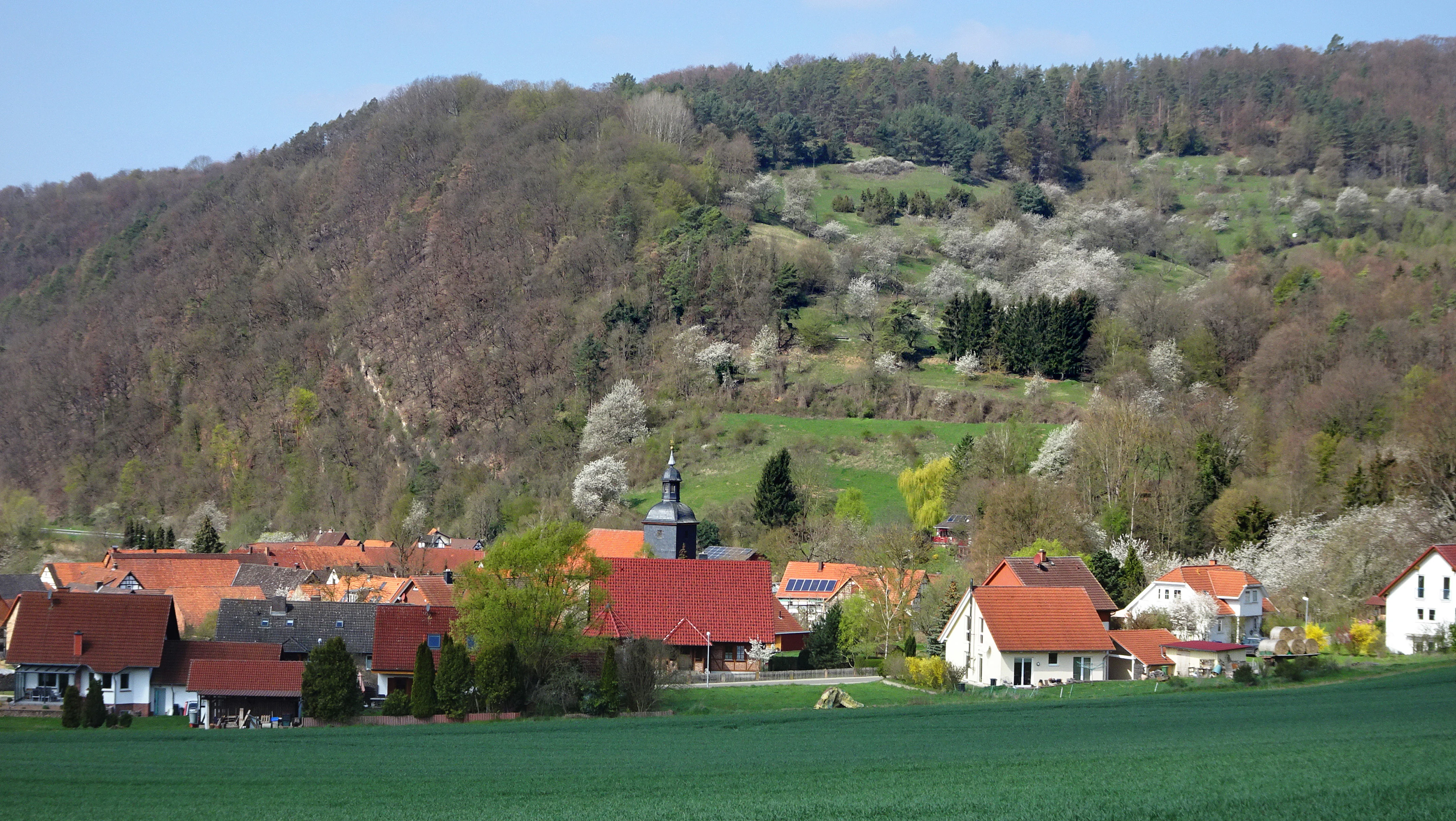
A rural landscape showing the village of Werleshausen with red-roofed buildings in the foreground, backed by a large, forested hill with grassy slopes and some white-flowering trees.
A view of the village of Werleshausen situated at the foot of the hills, including the Halbesberg and Ebenhoehe areas within the Ebenhoehe-Liebenberg nature reserve.

Ebenhöhe-Liebenberg history and protected-area timeline

The hills of Ebenhöhe, Halbesberg and Liebenberg have been shaped by long human use as woodland, cropland, and grazing land. Several of the open grassland areas on the Liebenberg were farmed as arable land until near the end of the Second World War. When this cultivation was abandoned, shrub encroachment began to take over the slopes; conservation managers later removed the encroaching scrub and helped convert the old fields into extensive, species-rich dry grassland known as Magerrasen.

The modern protected status of the area began on 7 March 1995, when the Regierungspräsidium in Kassel issued an ordinance declaring parts of the Liebenberg, Halbesberg and Ebenhöhe a Naturschutzgebiet. The stated purposes of this designation included protecting and developing the structurally rich forests, conserving the dry grasslands and rock communities as habitat for rare plants and animals, maintaining the small-scale mosaic of hedges, meadows, scrub, and traditional orchard land adjoining the woodland, and preserving the cultural landscape character shaped by agriculture and forestry.

In April 1999, the nature reserve was reported to the European Commission as a site of community importance within the cross-border Natura 2000 network. Following monitoring and management planning work, the area received its formal Fauna-Flora-Habitat designation under the Hessian Natura 2000 ordinance of January 2008. Management activities since that time have stressed maintaining open calcareous grassland on south-facing slopes, encouraging deadwood and old trees in the woodland, and supporting the gradual conversion of remaining conifer stands toward more natural broadleaf mixtures.

Ebenhöhe-Liebenberg landscape and geographic character

The relief of the reserve is shaped by three small hills rising from the right bank of the Werra. The Ebenhöhe reaches 314 metres, while the Liebenberg summit lies at 287 metres and the Halbesberg forms the southwestern shoulder of the protected area. The lowest parts of the reserve sit around 140 metres above sea level, giving a vertical span of well over 150 metres and producing noticeably different microclimates between the cool, shaded northerly aspects and the warm, sun-exposed southern slopes.

Geologically the hills combine limestone substrates, which support the calcareous grassland and orchid-beech woodland communities, with sandstone outcrops that create small rock faces and cliff ledges near the upper edges, including the area called Hasenkanzel. Small quarry faces along the Landesstraße 3469 have even produced a fragmentary example of a priority basophilic pioneer grassland community.

Hydrologically the landscape is dominated by the nearby Werra and the small Siesterbach, which traces the eastern edge of the reserve. Along this stream a narrow strip of alder alluvial forest, tall-herb vegetation, and wet meadow communities creates a sharp ecological contrast to the dry uplands just a short distance away. Forest roads, field tracks, and a longer-distance border-stone hiking trail, the Grenzsteinwanderung, cross the area and connect it to the wider Werra valley landscape.

Ebenhöhe-Liebenberg ecosystems, habitats, and plant life

Ecologically the reserve is defined by an unusually dense concentration of habitat types for its size. Nine natural and semi-natural habitat types of European conservation interest have been documented within the site, ranging from priority limestone pioneer grasslands and sub-Mediterranean semi-dry grasslands to nutrient-poor hay meadows, orchid-rich beech forest, oak-hornbeam forest, alder alluvial forest, and small sandstone rock vegetation communities.

The woodland component is largely dominated by Central European orchid- and limestone-beech forest on the warmer slopes, typically with a sparse field layer in which several orchid species occur alongside small sedges, lily of the valley, and swallow-wort. More shaded pockets support woodruff-beech woodland with a richer ground flora of woodruff, wild ginger, woodland barley, and a noticeably extensive carpet of wood spurge. On the Halbesberg, a small oak-hornbeam stand, probably originating from historic coppice management, includes wild service trees and field maples and harbours many of the same warm-loving species found in the beech forest.

The open habitats within the reserve give the protected area much of its conservation character. Old quarry embankments hold fragmentary pioneer calcareous grassland with characteristic species such as flattened meadow-grass, wall germander, and three-fingered saxifrage, while the larger semi-dry grasslands on the Liebenberg slopes display an Enzian-Schillergras association rich in small species including yellow oat-grass, stemless thistle, and spring potentilla. Nutrient-poor hay meadows of the Glatthaferwiesen type, small wet tall-herb strips along the Siesterbach, sandstone rock communities with characteristic ferns and mosses, and traditional orchard meadows round out the ecological profile.

Ebenhöhe-Liebenberg wildlife and species highlights

The wildlife of Ebenhöhe-Liebenberg reflects the mix of dry warm open habitats and woodland edges that characterise the reserve. Targeted faunal surveys in the project Grunddatenerhebung focused on butterflies, burnet moths, grasshoppers and dragonflies, which collectively respond strongly to the mosaic structure of the site.

In the summer of 2006, surveys using sight observations and sweep-netting across ten representative open-land plots recorded more than forty different daytime-flying butterfly and burnet moth species. Among the finds, species such as the Kronwicken-Dickkopffalter, mattscheckiger Braun-Dickkopffalter, thyme blue, golden eight, wood white, large fritillary, lesser purple emperor, and the Graubindiger Mohrenfalter are listed as threatened or on the warning list of the current Red Data Book for butterflies in Hesse. The thyme, sainfoin, and small five-spot burnet moths documented in the area are also regarded as endangered in the region.

Grasshopper surveys recorded thirteen species, including bush-crickets inhabiting the tall-herb forest edges, psocoptera and ground grasshoppers on the dry southwestern grasslands, and dense populations of the warmth-loving sickle-bearing bush-cricket on the south-facing slopes. These warm, insect-rich slopes serve as a maturation and feeding habitat for dragonflies; large numbers of banded demoiselle and common winter damselfly have been observed there, completing the picture of a relatively species-rich invertebrate fauna for a reserve of this size.

Ebenhöhe-Liebenberg conservation status and protection priorities

The conservation importance of Ebenhöhe-Liebenberg lies in the way several threatened European habitat types converge within a single, readily manageable area. The reserve is one of the Hessian sites that documents the orchid- and limestone-beech forest habitat type with detailed botanical evidence and protects a small but ecologically significant fragment of a priority basophilic pioneer grassland that is otherwise scarce in the region. Its dry and semi-dry calcareous grasslands, nutrient-poor hay meadows, and traditional orchard patches together preserve a flower-rich low-mountain landscape that has largely disappeared from more intensively farmed parts of Hesse.

Protection at the site operates on three nested administrative layers. The interior of the hills is covered by the 1995 national nature reserve (NSG), which regulates forestry, grassland use, and scrub management. The whole area is in turn embedded within the considerably larger Werra valley landscape protection area first declared in 1960, which buffers the core reserve against visually intrusive changes in the surrounding valley.

Internationally, the site has been part of the Natura 2000 system since 2008 as a Fauna-Flora-Habitat area, obliging the regional authorities to maintain near-natural, structurally rich woodland stands with sufficient deadwood, old trees, and habitat-typical tree species, and to keep the calcareous grasslands in unshaded, nutrient-poor condition. Routine Grunddatenerhebung monitoring, including the 2007 baseline survey by Bioplan Marburg and the surface condition assessments that followed, provides the data background for ongoing management of these conservation targets.

Ebenhöhe-Liebenberg cultural meaning and human context

The protected area sits within a landscape that carries dense traces of Central European political history as well as quieter marks of everyday rural life. From the boundary stone path known as the Grenzsteinwanderung, the historical line between the Kingdom of Prussia (KP) and the Electorate of Hesse (KH), fixed in 1836, can still be traced across the hills. Hedgerows, traditional Streuobstwiesen orchards, and the mosaic of small fields visible from the slopes also speak to generations of mixed rural land use.

On a larger scale, the Werleshausen area became an unusual theatre of post-war border history. The small north-south railway between Bebra and Eichenberg ran for about four kilometres through Soviet-occupied territory, and recurring interference with Allied supplies along this stretch led, under the so-called Wanfried Agreement, to a boundary correction that transferred several Hessian villages to the Soviet zone. Werleshausen and its neighbour Neuseesen, along with the railway, were assigned to the American sector. The reserve today lies quietly within this reconfigured landscape.

Top sights and standout views in Ebenhöhe-Liebenberg

Among the reserve's most distinctive features are the orchid-rich limestone beech woodlands on the warmer slopes, where several nationally rare woodland orchid species grow alongside small sedges and swallow-wort, and the mosaic of calcareous dry and semi-dry grasslands that harbour both characteristic plant associations and a rich butterfly and burnet moth fauna. The small but ecologically significant pioneer grassland fragment on an old quarry slope adds a layer of priority habitat that is rare in Hesse.

Other highlights include the sandstone cliff communities with characteristic ferns and mosses along the upper rocks near the Hasenkanzel, the gallery of alder alluvial forest that traces the Siesterbach along the eastern boundary, and the Grenzsteinwanderung, which links the reserve's natural value with easily readable historic boundary stones. The combination of overlapping nature reserve, Natura 2000 site, and surrounding landscape protection area gives the area a layered conservation framework unusual for a reserve of this size.

Best time to visit Ebenhöhe-Liebenberg

Late spring and summer are generally the most rewarding periods to experience Ebenhöhe-Liebenberg. In late spring the orchid- and limestone-beech woodlands show their most distinctive wildflower displays, while the dry and semi-dry grasslands on the Liebenberg slopes become visibly rich in colour and insect activity from May into midsummer. Many of the surveys of butterflies, burnet moths, grasshoppers and dragonflies on which the reserve's ecological profile is based were conducted during the summer months, when these open habitats and warm slopes are at their most active.

Visiting in autumn still rewards walkers with lowland beech colour and an attractive cool atmosphere in the closed forest, while winter brings a quieter, more architectural view of the hills and their boundary stones. Because the reserve contains both dry upland habitats and a small alluvial strip along the Siesterbach, the seasonal experience of a visit can shift noticeably between the open south-facing slopes and the more sheltered stream valley within a short distance.

Monthly climate preview

Long-term representative monthly climate measurements and temperature variations across the protected coordinate

Ebenhöhe-Liebenberg Climate Normals, Annual Temperature and Precipitation Profiles

Historical data records a measured annual temperature and precipitation rhythm across twelve months at the representative coordinate for Ebenhöhe-Liebenberg. Examining the complete monthly climate normals provides deeper context regarding long-term temperature ranges and precipitation patterns.
Annual mean8 °C
-1 °C18 °C
Jan-1°
Feb
Mar
Apr
May12°
Jun16°
Jul18°
Aug18°
Sep14°
Oct
Nov
Dec
Warmest month
July

18.2 °C

Coolest month
January

-0.9 °C

Wettest month
July

2.6 mm/day

Driest month
April

1.5 mm/day

Park location guide

Geography guide, regional context, and park location map for Ebenhöhe-Liebenberg

Ebenhöhe-Liebenberg park geography, regions, and map view in Germany

Understand where Ebenhöhe-Liebenberg sits in Germany through a broader geographic reading of the surrounding landscape, nearby location context, and its mapped position within the national park landscape.

How Ebenhöhe-Liebenberg fits into Germany

Germany is a federal republic in Western and Central Europe with a population of over 83 million across sixteen constituent states. It is Europe's largest economy by nominal GDP and a major global exporter and importer. The capital is Berlin, and the country borders Denmark, Poland, Czech Republic, Austria, Switzerland, France, Luxembourg, Belgium, and the Netherlands.

Wider geography shaping Ebenhöhe-Liebenberg in Germany

Germany is located in Western and Central Europe, spanning 357,022 km². It borders Denmark to the north, Poland and the Czech Republic to the east, Austria and Switzerland to the south, and France, Luxembourg, Belgium, and the Netherlands to the west. The country has coastlines on the Baltic Sea and North Sea to the north, with the Alps located in the southern region.

Map view of Ebenhöhe-Liebenberg

Use this park location map to pinpoint Ebenhöhe-Liebenberg in Germany, understand its exact geographic position, and read its mapped placement within the surrounding landscape more clearly.

Pigeon | © OpenStreetMap contributors

Location context for Ebenhöhe-Liebenberg

Werra-Meißner-Kreis
Recorded earthquake history

Explore the Historical Earthquake Catalogue for Ebenhöhe-Liebenberg

Examine the record of seismic activity identified in the vicinity of the Ebenhöhe-Liebenberg nature reserve. MoriAtlas provides a clear view of historical earthquake data including event magnitudes and epicentre distances to support your exploration of the regional landscape context.

Ebenhöhe-Liebenberg Earthquake History

Catalogued events

3 events

Strongest magnitude

Magnitude 3.6

Most recent event

Mar 30, 1995

This history includes earthquakes recorded inside the park or within 50 km of its borders

Explore the terrain, orchid-rich beech forests, and limestone grasslands through detailed imagery.

Ebenhöhe-Liebenberg Photos and Scenery: Visualizing the Protected Landscape

Visual documentation reveals the distinct topography and habitat mosaics that define the Ebenhöhe-Liebenberg nature reserve. Photographic records capture the limestone slopes, sandstone outcrops, and protected valley environments in sharp geographic context.

A rural landscape showing the village of Werleshausen with red-roofed buildings in the foreground, backed by a large, forested hill with grassy slopes and some white-flowering trees.

A group of fruit trees in white blossom standing on a green hillside under a clear blue sky.

Park atlas

Compare regional nature reserves, limestone hills, and river valley conservation sites

Exploring Parks Near Ebenhöhe-Liebenberg and Surrounding Protected Landscapes

Browse nearby national parks and protected areas connected to the broader geographic context of the Hessian highlands. Compare surrounding low mountain terrain, river valleys, and rare woodland habitats to understand regional conservation patterns.
A soft watercolor illustration depicting a winding river landscape with lush trees and rolling hills in the background.
Nature reserveLandkreis Eichsfeld
About 2.9 km away#1 closest

East

Kelle, Teufelskanzel Nature Reserve: Geographic Overview and Protected Area Atlas

Steep slopes and sandstone ridges in Landkreis Eichsfeld

Situated along the Höheberg ridge in Thuringia, Kelle, Teufelskanzel represents a vital 200 hectare nature reserve. Its geography is defined by deep V-shaped valleys, dramatic rock outcrops like the Teufelskanzel, and a dense mix of deciduous forests that form part of the historic Inner German Border conservation zone.

Area
2.002 km²
Established
1996
IUCN
IV
Relief
Mountain
A horizontal watercolor illustration depicting rolling green hills, scattered trees, and soft mountain silhouettes against a pale sky.
Protected areaGermany
4.2 km away#2 closest

West

Kalkmagerrasen bei Roßbach: Protected Calcareous Grassland and Juniper Landscape in Germany

Geographic atlas and protected area overview in Hesse

Kalkmagerrasen bei Roßbach consists of five distinct plots that protect rare Enzian Schillergras Rasen communities on shallow Zechstein limestone soils. This site remains a critical stronghold for diverse orchid populations and protected butterfly species within the Werra Meißner region. The mosaic of juniper, flowering herbs, and historic cherry orchards creates a unique Mediterranean character rarely found in central German hill country.

Area
0.551 km²
Established
1996
Relief
Upland
Climate
Temperate
A horizontal watercolor illustration depicting gentle rolling hills, grassy meadows, and distant mountain silhouettes in muted pastel tones.
Nature reserveThuringia
4.6 km away#3 closest

East

Röhrsberg - Hasenwinkel - Mühlberg: Mapping the Protected Landscapes of Thuringia

Geological ridge systems and native forest habitat networks.

The Röhrsberg - Hasenwinkel - Mühlberg nature reserve represents a significant protected area in Thuringia, characterized by the juxtaposition of Muschelkalk limestone hills and Zechstein dolomite ridges. This site offers a concentrated view of regional terrain, shifting from closed beech forests to open juniper heaths. It serves as an essential geographic reference for understanding the ecological mosaic of the lower Werra hill country.

Area
4.51 km²
Established
1999
IUCN
IV
Relief
Upland
A horizontal watercolor painting showing a winding river flowing through a lush valley with forested hills in the background.
Protected areaHesse
5 km away#4 closest

Northwest

Freudenthal bei Witzenhausen Protected Landscape and Wetland Geography in Hesse

A restored gravel pit wetland system in the northern Hesse Werra valley.

Freudenthal bei Witzenhausen represents a high-value conservation landscape within Hesse, serving as a primary site for breeding and migratory waterbirds. The reserve comprises three interconnected quarry lakes surrounded by alluvial woodland, ruderal vegetation, and meadows. This habitat mosaic is part of the Natura 2000 network, providing essential ecological connectivity within the riverine corridor of the lower Werra valley.

Area
0.76 km²
Established
1980
Relief
Lowland
Climate
Temperate
A horizontal watercolor illustration showing a soft, panoramic landscape with rolling green hills, small clumps of trees, and rocky formations on a white background.
Nature reserveLandkreis Eichsfeld
About 5.9 km away#5 closest

East

Hasenwinkel bei Fretterode: Protected Dolomite Ridge and Juniper Heath in Landkreis Eichsfeld

Nature reserve geography and landscape analysis

The Hasenwinkel bei Fretterode nature reserve is characterized by a prominent dolomite ridge rising above the agricultural lands of Landkreis Eichsfeld. This site offers an look at historically grazed calcareous grasslands and rocky outcrops. Our mapping covers its extent as a vital component of the regional protected-area network, showcasing its ecological importance and distinctive geology.

Area
0.062 km²
Established
1939
IUCN
IV
Relief
Upland
Watercolor painting of a mountain landscape with green slopes, coniferous forests, and rocky outcroppings under a soft, light-filled sky.
Nature reserveHesse
6.6 km away#6 closest

South

Meißner Nature Reserve in Northern Hesse: Mapping the Hoher Meißner Basaltic Massif

A comprehensive look at forest wilderness, bogs, and volcanic geology

Covering roughly 930 hectares, the Meißner nature reserve in northern Hesse protects an ecologically distinct upland landscape. The area features a significant basalt plateau, ancient scree slopes, mountain meadows, and hanging spring bogs, offering a prime example of protected central German topography and forest wilderness.

Area
9.322 km²
Established
1989
IUCN
IV
Relief
Mountain
A minimalist watercolor painting featuring soft green trees and rolling hills in the background against a light, airy white backdrop.
Nature reserveWerra-Meißner-Kreis
6.9 km away#7 closest

Northwest

Ermschwerder Heegen Nature Reserve: Muschelkalk Ridge and Floodplain Geography

Protected mosaic of forests, marshes, and meadows in northern Hesse

Ermschwerder Heegen preserves a compact but ecologically significant landscape in the Werra-Meißner-Kreis. Its unique topography features a limestone ridge dropping into the Werra valley, supporting a rich mixture of forest, orchard, and wetland habitats that rank among the most important in the region for biodiversity.

Area
0.37 km²
Established
1985
IUCN
IV
Wide watercolor illustration of green trees and hills with purple mountains in the background under a pale sky.
Nature reserveThuringia
8.5 km away#8 closest

Southeast

Stein, Rachelsberg, Gobert: A Protected Limestone Landscape in Western Thuringia

Mapping a historic nature reserve and beech forest complex

Stein, Rachelsberg, Gobert stands as a key protected area within Thuringia. This nature reserve offers deep insights into limestone ridge geography, historic border woodland continuity, and diverse habitats ranging from dry grasslands to tufa springs and orchid-rich beech forests.

Area
7.16 km²
Established
1999
IUCN
IV
Relief
Mountain

Common questions about visiting, size, designation, and location context for Ebenhöhe-Liebenberg

Ebenhöhe-Liebenberg FAQs for park facts, access, geography, and protected area context

Find quick answers about Ebenhöhe-Liebenberg, including protected-area facts, park geography, trail and visitor context, and how the park fits into its surrounding country and regional landscape.
MoriAtlas Explorer

Continue Your Protected Areas Search Across the Global Atlas

Deepen your exploration by continuing the structured search for national parks and protected areas worldwide. Utilize the comprehensive filtering capabilities to compare different conservation landscapes and refine your understanding of global park geography. Discover more about the distribution and characteristics of protected natural areas.

Global natural geography