

Mori Atlas logo
Nature reserveEkboles Potamon Ezousas, Xerou, Kai Diarizou

Examining the estuarine geography and bird habitat boundaries of this Mediterranean protected landscape

Ekboles Potamon Ezousas, Xerou, Kai Diarizou: A Vital Coastal Nature Reserve in Cyprus

Ekboles Potamon Ezousas, Xerou, Kai Diarizou encompasses the convergence of three river systems along the southwestern coastline of Cyprus. This Natura 2000 Special Protection Area serves as a critical refuge within the Mediterranean ecoregion, where freshwater outflows meet marine environments to support resident and migratory bird populations. The site provides essential ecological functions across its coastal flats and river-mouth corridors, marking it as a key zone for avian conservation in the eastern Mediterranean.

bird sanctuaryriver outletsestuariesNatura 2000Special Protection AreaMediterranean ecoregion

Ekboles Potamon Ezousas, Xerou, Kai Diarizou

Nature reserve

Park overview

Structured park overview, official facts, and landscape profile for Ezousas, Xeros, and Diarizos River Outlets

Ezousas, Xeros, and Diarizos River Outlets park facts, protected area profile, and essential visitor context

Review the core facts for Ezousas, Xeros, and Diarizos River Outlets, including designation, size, terrain, visitor scale, habitats, and operating context in one park-focused overview.

About Ezousas, Xeros, and Diarizos River Outlets

Ezousas, Xeros and Diarizos River Outlets is a Natura 2000 Special Protection Area in the southwestern part of Cyprus, classified specifically for the protection of birds. The site was designated in October 2007, and its formal Natura 2000 site code is CY4000018. Covering approximately 827 hectares entirely on land, the protected area is defined by the outlet zones of three named rivers, the Ezousas, Xeros, and Diarizos, as they approach and reach the Mediterranean coast.

In geographic terms, the site sits in the Mediterranean ecoregion, where Cyprus's relatively short river systems descend from inland highlands and empty into the sea. The area therefore captures the ecological transition from freshwater river corridors to saline coastal habitats, including stretches of estuary, lowland reaches, and adjacent Mediterranean land. Despite its modest size, this convergence of three river outlets in relatively close proximity concentrates habitat value in a compact zone.

Ecologically, the site is defined almost entirely by its bird fauna: 85 protected bird species underpin its designation. The species list spans raptors, herons, waders, terns, larks, warblers, shrikes, pipits, wheatears, buntings, and other bird groups typical of Mediterranean lowlands and coastal wetlands. This broad species spectrum reflects the way the site's varied habitats, including river outlets, surrounding open terrain, and nearby Mediterranean coastal environments, together provide year-round and seasonal conditions for different bird communities.

As a Natura 2000 SPA, Ezousas, Xeros and Diarizos River Outlets is a piece of Cyprus's contribution to the European Union's coordinated network of protected bird sites. Its role is not as a showpiece landscape but as a working ecological refuge, one whose value is measured in the diversity and presence of birdlife that depends on these river-mouth habitats surviving intact.

Quick facts and research context for Ezousas, Xeros, and Diarizos River Outlets

Ezousas, Xeros and Diarizos River Outlets is a Special Protection Area (SPA) under the Natura 2000 network, designated in October 2007. The site spans approximately 827 hectares entirely on land in southwestern Cyprus, where the Ezousas, Xeros, and Diarizos rivers reach the coast. Its designation is based on the protection of 85 bird species, making it one of the bird-focused Natura 2000 sites in Cyprus's Mediterranean ecoregion.

Protection and recognition

Documented terrestrial protection scope, management boundaries, and Natura 2000 listings.

Ekboles Potamon Ezousas, Xerou, Kai Diarizou Protection Status and Recognition Data

Terrestrial protection status, management scope, and verified international recognition sources outline the conservation framework for Ekboles Potamon Ezousas, Xerou, Kai Diarizou. Official Natura 2000 data entries provide structured documentation for geographic boundaries and administrative designations.
Park context

Deeper park guide and search-rich context for Ezousas, Xeros, and Diarizos River Outlets

Ezousas, Xeros, and Diarizos River Outlets history, landscape, wildlife, and travel context

Explore Ezousas, Xeros, and Diarizos River Outlets through its history, landscape character, ecosystems, wildlife, conservation priorities, cultural context, and seasonal travel timing in a structured park guide built for atlas discovery and search intent.

Why Ezousas, Xeros, and Diarizos River Outlets stands out

The site is best known as a bird-focused Natura 2000 area, protecting 85 bird species across three river-mouth habitats. Its identity is defined by estuarine ecology rather than dramatic scenery: the convergence of freshwater outflows with coastal Mediterranean environments creates conditions that attract resident breeders, winter visitors, and passage migrants alike. Among the species associated with the area are notable raptors such as the Bonelli's eagle, short-toed snake eagle, lesser spotted eagle, and several harrier and falcon species. Waders, herons, terns, larks, warblers, shrikes, and waterbirds such as the glossy ibis and common crane further reinforce the site's profile as a multi-habitat bird sanctuary at the meeting point of rivers and sea in the eastern Mediterranean.

Ezousas, Xeros, and Diarizos River Outlets history and protected-area timeline

The protected area was formally designated as a Special Protection Area, a Natura 2000 bird protection site, in October 2007. The designation was based specifically on the protection of 85 animal species, all of which are birds, reflecting Cyprus's effort to identify and secure the most important bird habitats within its territory.

Prior to this formal Natura 2000 designation, the three river systems gave the region its defining geographic character, but the area did not carry its current unified protected-area identity. The 2007 designation effectively consolidated recognition of these river outlets as a single ecologically coherent site worthy of coordinated protection as part of the EU-wide Natura 2000 network.

Ezousas, Xeros, and Diarizos River Outlets landscape and geographic character

The physical character of the protected area is defined by the convergence of three named rivers, the Ezousas, Xeros, and Diarizos, with the Mediterranean coast of southwestern Cyprus. Although the site is entirely on land, its landscape is shaped by the freshwater-to-marine transition that occurs where these rivers reach the coast. The result is a low-lying estuarine landscape interspersed with the open Mediterranean countryside typical of the region.

The terrain reflects the Mediterranean ecoregion more broadly: lowland river corridors, coastal flats, and adjacent terrestrial habitats meet in a relatively compact area. Rather than dramatic elevations or extensive wilderness, the site's landscape value comes from the structural diversity produced by rivers, estuarine margins, and the surrounding coastal mosaic.

Ezousas, Xeros, and Diarizos River Outlets ecosystems, habitats, and plant life

Ecologically, the protected area falls within the Mediterranean ecoregion of Cyprus, and its natural value is concentrated almost entirely in its bird fauna and the habitats that support it. The combination of three river outlets close to the sea produces ecological conditions that support both freshwater-associated and coastal-associated species, as well as a wide range of terrestrial Mediterranean birdlife.

The site's ecological profile is unusual in that, although the promotion text notes no formally listed habitat types under the Natura 2000 habitat annexes, the bird protection designation nonetheless recognizes the area as ecologically significant. This reflects how habitat value can be defined through fauna of European conservation concern even where habitat classifications are limited.

Ezousas, Xeros, and Diarizos River Outlets wildlife and species highlights

The wildlife profile of Ezousas, Xeros and Diarizos River Outlets is overwhelmingly bird-focused, with 85 protected bird species forming the formal basis of the site's designation. The recorded fauna includes a notable concentration of raptors: the Bonelli's eagle, short-toed snake eagle, Levant sparrowhawk, hen harrier, pallid harrier, Montagu's harrier, lesser spotted eagle, black kite, and several falcon species including the peregrine falcon, merlin, lesser kestrel, and Eleonora's falcon.

Wading birds and waterbirds are well represented, with species such as the black-winged stilt, golden plover, little stint, ruff, white stork, grey heron, purple heron, squacco heron, glossy ibis, common crane, black-crowned night heron, little egret, ferruginous duck, and the black-headed Mediterranean gull also recorded.

A wide range of smaller passerines and Mediterranean specialties further enriches the site's bird fauna. These include the great reed warbler, melodious warbler, red-backed shrike, lesser grey shrike, masked shrike, wood lark, calandra lark, short-toed lark, crested lark, European bee-eater, European roller, European nightjar, Eurasian hoopoe, Cyprus wheatear, isabelline wheatear, black-eared wheatear, northern wheatear, common stonechat, whinchat, collared flycatcher, semi-collared flycatcher, spotted flycatcher, common redstart, thrush nightingale, Rüppell's warbler, Cyprus warbler, turtle dove, and the lapwing. Together this list illustrates the site's role as a productive bird-protection area within the broader Mediterranean migration and wintering landscape.

Ezousas, Xeros, and Diarizos River Outlets conservation status and protection priorities

Conservations, the site's significance lies in its formal status as a Natura 2000 Special Protection Area within the European Union's network of protected bird sites. Designated in October 2007, the area was specifically recognized because it supports 85 bird species of European conservation concern, making it a strategic component of Cyprus's contribution to international bird protection.

The site's conservation logic is rooted in habitat function rather than landscape grandeur: the river outlets of the Ezousas, Xeros, and Diarizos provide ecological conditions that many protected bird species depend on, whether as breeding grounds, wintering habitat, or migratory stopover points. Protecting these river-mouth systems in an integrated way helps safeguard the ecological processes that maintain bird populations across the eastern Mediterranean.

Top sights and standout views in Ezousas, Xeros, and Diarizos River Outlets

Ezousas, Xeros and Diarizos River Outlets is a Nature 2000 SPA in southwestern Cyprus, entirely on land, covering about 827 hectares across the outlets of three named rivers. Its 2007 designation on the basis of 85 protected bird species makes it a leading bird-focused Natura 2000 site in the country, with particular conservation significance for raptors, waders, waterbirds, and Mediterranean passerines that depend on these river-mouth and coastal habitats.

Best time to visit Ezousas, Xeros, and Diarizos River Outlets

As a bird-protection area, the site has visibility conditions that vary with bird activity across the seasons. Migratory periods in spring and autumn typically concentrate the greatest variety and abundance of birdlife in Mediterranean lowlands, while winter can bring additional species such as the common crane. The site's specific calendar dynamics are best understood through local ornithological observation rather than general tourism timing.
Monthly climate preview

Long-term representative monthly temperature and precipitation patterns across Cyprus

Ekboles Potamon Ezousas, Xerou, Kai Diarizou Climate Normals and Annual Temperature Rhythm

Representative coordinates record measured monthly temperature and precipitation cycles spanning annual cycles for Ekboles Potamon Ezousas, Xerou, Kai Diarizou. Reviewing the complete twelve-month profile provides detailed long-term climate normals and deeper comparative statistics for Cyprus protected geography.
Annual mean21 °C
15 °C27 °C
Jan15°
Feb15°
Mar16°
Apr18°
May21°
Jun24°
Jul27°
Aug27°
Sep26°
Oct24°
Nov21°
Dec17°
Warmest month
August

27.2 °C

Coolest month
February

14.9 °C

Wettest month
December

3 mm/day

Driest month
July

0.1 mm/day

Park location guide

Geography guide, regional context, and park location map for Ezousas, Xeros, and Diarizos River Outlets

Ezousas, Xeros, and Diarizos River Outlets park geography, regions, and map view in Cyprus

Understand where Ezousas, Xeros, and Diarizos River Outlets sits in Cyprus through a broader geographic reading of the surrounding landscape, nearby location context, and its mapped position within the national park landscape.

How Ezousas, Xeros, and Diarizos River Outlets fits into Cyprus

Cyprus is an island nation in the eastern Mediterranean Sea, positioned at the crossroads of Europe, Africa, and Asia. The Republic of Cyprus governs the southern portion of the island, with Nicosia as its capital and largest city. The island has a complex political situation due to the Turkish occupation in the north and contains British military bases in the south. Cyprus gained independence from Britain in 1960 and is a member of the European Union.

Wider geography shaping Ezousas, Xeros, and Diarizos River Outlets in Cyprus

Cyprus is an island located in the eastern Mediterranean Sea, off the coast of the Levant in West Asia. The island lies approximately 75 km south of Turkey, 105 km west of Syria, and 380 km north of Egypt. The terrain varies from mountainous regions in the north and interior to plains and coastal areas. The Troodos Mountains dominate the central and southwestern part of the island. The island has no land borders as it is entirely surrounded by sea.

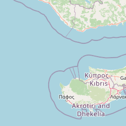
Map view of Ezousas, Xeros, and Diarizos River Outlets

Use this park location map to pinpoint Ezousas, Xeros, and Diarizos River Outlets in Cyprus, understand its exact geographic position, and read its mapped placement within the surrounding landscape more clearly.

Pigeon | © OpenStreetMap contributors
Recorded earthquake history

Examine Recorded Seismic History Near Ekboles Potamon Ezousas, Xerou, Kai Diarizou

Access a structured catalogue of historical seismic events recorded in the vicinity of this protected river-mouth landscape. MoriAtlas provides these records to support geographic research and regional context exploration for the coastal zones of southwestern Cyprus.

Ekboles Potamon Ezousas, Xerou, Kai Diarizou Earthquake History

Catalogued events

449 events

Strongest magnitude

Magnitude 6.8

Most recent event

Dec 12, 2025

This history includes earthquakes recorded inside the park or within 50 km of its borders

Park atlas

Compare connected wetland habitats, river outlets, and coastal reserves across southwestern Cyprus

Other Parks Near Ekboles Potamon Ezousas, Xerou, Kai Diarizou and Regional Protected Areas

Browsing other parks near Ekboles Potamon Ezousas, Xerou, Kai Diarizou reveals related coastal habitats and river mouths across the region. Expanding the geographic scope helps place local estuarine environments and protected bird sanctuaries into a broader regional conservation context.
Nature reserveCyprus
1.6 km away#1 closest

East

Koilada Diarizou Nature Reserve and Mediterranean River Valley Geography

Protected riparian landscapes in the Paphos district of Cyprus

Koilada Diarizou represents a prime example of a Mediterranean river valley protected area in western Cyprus. This nature reserve sustains a mosaic of rocky limestone slopes, cypress woodlands, and seasonal riparian channels that serve as a critical reference point for understanding the island's unique ecological connectivity.

Area
13.58 km²
Established
2002
Relief
Mixed relief
Climate
Mediterranean
Nature reserveCyprus
1.8 km away#2 closest

Northeast

Koilada Ezousas: Protected Inland Valley Landscapes and Map Geography in Western Cyprus

Natura 2000 designated nature reserve in the Paphos district

Koilada Ezousas represents a strategically mapped protected area in western Cyprus, characterized by its extensive inland valley terrain. The site acts as a critical refuge within the Mediterranean ecoregion, supporting a high concentration of raptors and endemic passerines. Understanding its geographic spread provides insight into the broader network of protected corridors across the island.

Area
56.27 km²
Established
2019
Climate
Mediterranean
Scope
Terrestrial
Nature reservePaphos District
3.5 km away#3 closest

East

Cha-Potami Nature Reserve: Protected Riverine Geography in Paphos District, Cyprus

River valley ecosystems and Mediterranean protected terrain

Cha-Potami spans a twelve-kilometer river stretch characterized by deep, narrow valleys and varied topography. This protected area offers a look into the rich ecological stratification of southwestern Cyprus, from dense riverside corridors and cypress-dotted slopes to rugged, raptor-nesting cliffside gorges that define the local landscape character.

Area
26.266 km²
Established
2000
Relief
Upland
Climate
Mediterranean
Nature reserveCyprus
4.9 km away#4 closest

East

Akrotirio Aspro - Petra Romiou Nature Reserve: Cyprus Coastal Geography and Habitat Map

Mediterranean coastal cliffs, bird habitats, and protected conservation landscapes

Akrotirio Aspro - Petra Romiou is an ecologically dense nature reserve in Cyprus, recognized for its varied Mediterranean terrain. The landscape transitions from iconic sea-stack formations and coastal cliffs into juniper matorral, pine forests, and riparian galleries. This site remains a crucial protected area for ornithological research and habitat connectivity across the southern Cypriot coastline.

Area
24.895 km²
Established
2004
Relief
Upland
Climate
Mediterranean
Nature reserveCyprus
6.3 km away#5 closest

Northeast

Episkopi Morou Nerou: Mapping the Protected Nature Reserve Landscapes of Western Cyprus

A regional geography of river valleys, riparian galleries, and forest mosaics

Located in western Cyprus, Episkopi Morou Nerou is a notable nature reserve spanning river valleys and Mediterranean scrubland. This protected area supports an array of habitats, from oriental plane forests and poplar galleries to open phrygana and pseudo-steppe grasslands, serving as a critical sanctuary for diverse bird populations and native plant species.

Area
4.193 km²
Established
2002
Relief
Mixed relief
Climate
Mediterranean
Nature reserveCyprus
About 6.5 km away#6 closest

Northwest

Faros Kato Pafou Nature Reserve: Coastal Protected Area Geography and Map

Essential Mediterranean habitat and bird protection site in Cyprus

Examine the ecological footprint of Faros Kato Pafou, a significant nature reserve on the Cyprus coast. This site protects a dense sequence of Mediterranean habitats, including shifting dunes, sea-cliff flora, and native forest. Its high concentration of protected bird species highlights the importance of preserving compact, intact coastal corridors within the broader eastern Mediterranean geography.

Area
0.877 km²
Established
2005
Relief
Lowland
Climate
Mediterranean
Nature reserveCyprus
11 km away#7 closest

North

Koili - Mavrokolympos Nature Reserve: Mapping the Protected Landscapes of Interior Cyprus

A vital Mediterranean sanctuary defined by diverse habitats and limestone terrain.

Koili - Mavrokolympos stands as an essential nature reserve in the Cypriot interior, encompassing a dense mosaic of cypress forests, Oriental plane woodlands, and sun-drenched phrygana. This protected area offers deep insight into Mediterranean biodiversity, highlighting the intersection of complex hydrology and rocky, undulating limestone topography within a compact, ecologically significant boundary.

Area
2.968 km²
Established
2002
Relief
Mixed relief
Climate
Mediterranean
Protected areaCyprus
16 km away#8 closest

Northeast

Gkremoi Chanoutari Protected Area; Mapping Cyprus Inland Landscapes and Terrain

A critical Mediterranean bird sanctuary within the Troodos foothill region.

Gkremoi Chanoutari encompasses a unique mix of rocky crags, scrubby slopes, and rural hillsides across 2,470 hectares in the interior of Cyprus. This protected area serves as a primary site for cliff-nesting raptors and Mediterranean avifauna, offering a detailed look at the island's complex topography and mountain-to-valley ecological transitions.

Area
24.698 km²
Established
2007
Climate
Mediterranean
Scope
Terrestrial

Common questions about visiting, size, designation, and location context for Ezousas, Xeros, and Diarizos River Outlets

Ezousas, Xeros, and Diarizos River Outlets FAQs for park facts, access, geography, and protected area context

Find quick answers about Ezousas, Xeros, and Diarizos River Outlets, including protected-area facts, park geography, trail and visitor context, and how the park fits into its surrounding country and regional landscape.
MoriAtlas Explorer

Continue Your Protected Areas Search Across the Global Atlas

Deepen your exploration by continuing the structured search for national parks and protected areas worldwide. Utilize the comprehensive filtering capabilities to compare different conservation landscapes and refine your understanding of global park geography. Discover more about the distribution and characteristics of protected natural areas.

Global natural geography