
Mori Atlas logo
Nature reserveErlensteg von Bieber

A dense mosaic of rare forest communities, wet meadows, and sedge wetlands along the Bieber stream

Erlensteg von Bieber Nature Reserve: Mapped Protected Landscapes and Regional Geography in Hessen

(Naturschutzgebiet Erlensteg von Bieber)

Erlensteg von Bieber serves as a protected ecological refuge within the urban landscape of Hessen. This nature reserve sustains a diverse patchwork of habitats, including dry fallow land, damp meadow grasslands, and lowmoor vegetation. Spanning approximately 75 hectares, the area offers a unique study of small scale conservation where woodland corridors meet saturated floodplains and botanical strongholds for marsh orchids.

nature reservewet meadowsedge wetlandlowmoorfloodplaindeciduous forest
A flat-style digital illustration of a serene river valley surrounded by steep cliffs and pine forests with a small waterfall visible in the background.

Erlensteg von Bieber

Nature reserve

Park overview

Structured park overview, official facts, and landscape profile for Erlensteg von Bieber

Erlensteg von Bieber park facts, protected area profile, and essential visitor context

Review the core facts for Erlensteg von Bieber, including designation, size, terrain, visitor scale, habitats, and operating context in one park-focused overview.

About Erlensteg von Bieber

Erlensteg von Bieber sits along the Bieber stream in the Bieber district of Offenbach am Main, a city on the southeastern edge of the Rhine-Main metropolitan region in Hesse. Despite its location within a largely urbanized area, the reserve functions as a green ecological island, preserving habitats that reflect both the natural floodplain influence of the stream and the lighter, drier soils found elsewhere on the site. The protection of the area is part of a broader effort to safeguard biodiversity in the outlying districts of Offenbach.

The reserve's defining feature is the combination of contrasting habitat types in close proximity. The wetter areas follow the Bieber stream and its floodplain, supporting damp meadows and wetlands dominated by sedges and lowmoor plant communities. Surrounding these wet zones are drier stands hosting rare forest types and fallow land on poor soils, which together create a layered landscape of ecological transitions. The diversity of microhabitats within such a limited area gives Erlensteg von Bieber an unusually rich character for a small urban-adjacent reserve.

The forested parts of the reserve cover approximately three quarters of the total area, while the remaining northwestern quarter is taken up by extensively managed hay meadows and a few small fields. This land use pattern preserves traditional meadow cultivation, which is itself a key conservation strategy for maintaining the floral diversity of the wet meadows. The reserve thus represents an active balance between continued low-intensity human use and ecological protection, rather than a strict no-intervention approach.

From a broader perspective, Erlensteg von Bieber is one of two formally designated nature reserves within the city limits of Offenbach am Main, alongside the Rumpenheimer und Bürgeler Kiesgruben, a former gravel pit site. The pair represents the city's principal protected natural areas and illustrates how even densely populated municipalities in Hesse maintain significant pockets of high-quality habitat through formal nature conservation designations.

Quick facts and research context for Erlensteg von Bieber

Erlensteg von Bieber is a nature reserve (Naturschutzgebiet) in the city of Offenbach am Main, Hesse, Germany. It covers roughly 75 hectares and has been protected since March 1996. It is classified under IUCN Category IV as a Habitat/Species Management Area, underscoring its emphasis on conserving specific habitat types rather than large-scale wilderness. The reserve is identified in German nature conservation records under the NSG number 1413002 and in the World Database on Protected Areas under WDPA ID 162994.

Protection and recognition

Examine documented conservation metrics and administrative status records.

Erlensteg von Bieber Protection Status and International Recognition

Erlensteg von Bieber maintains structured data tracking official protection parameters and administrative registry records. Review verified conservation status details alongside international database identifiers for comprehensive geographic analysis.

Protection details

WDPA ID
162994
Park context

Deeper park guide and search-rich context for Erlensteg von Bieber

Erlensteg von Bieber history, landscape, wildlife, and travel context

Explore Erlensteg von Bieber through its history, landscape character, ecosystems, wildlife, conservation priorities, cultural context, and seasonal travel timing in a structured park guide built for atlas discovery and search intent.

Why Erlensteg von Bieber stands out

Erlensteg von Bieber is best known for its compact yet unusually diverse mosaic of habitats: wet meadows, lowmoor and sedge vegetation, rare forest communities, and dry fallow land all occur within a very small area. This concentration of different habitat types gives the reserve an ecological richness that is uncommon for a site situated so close to a major city. The presence of the broad-leaved marsh orchid on its damp meadows is also a notable botanical feature.
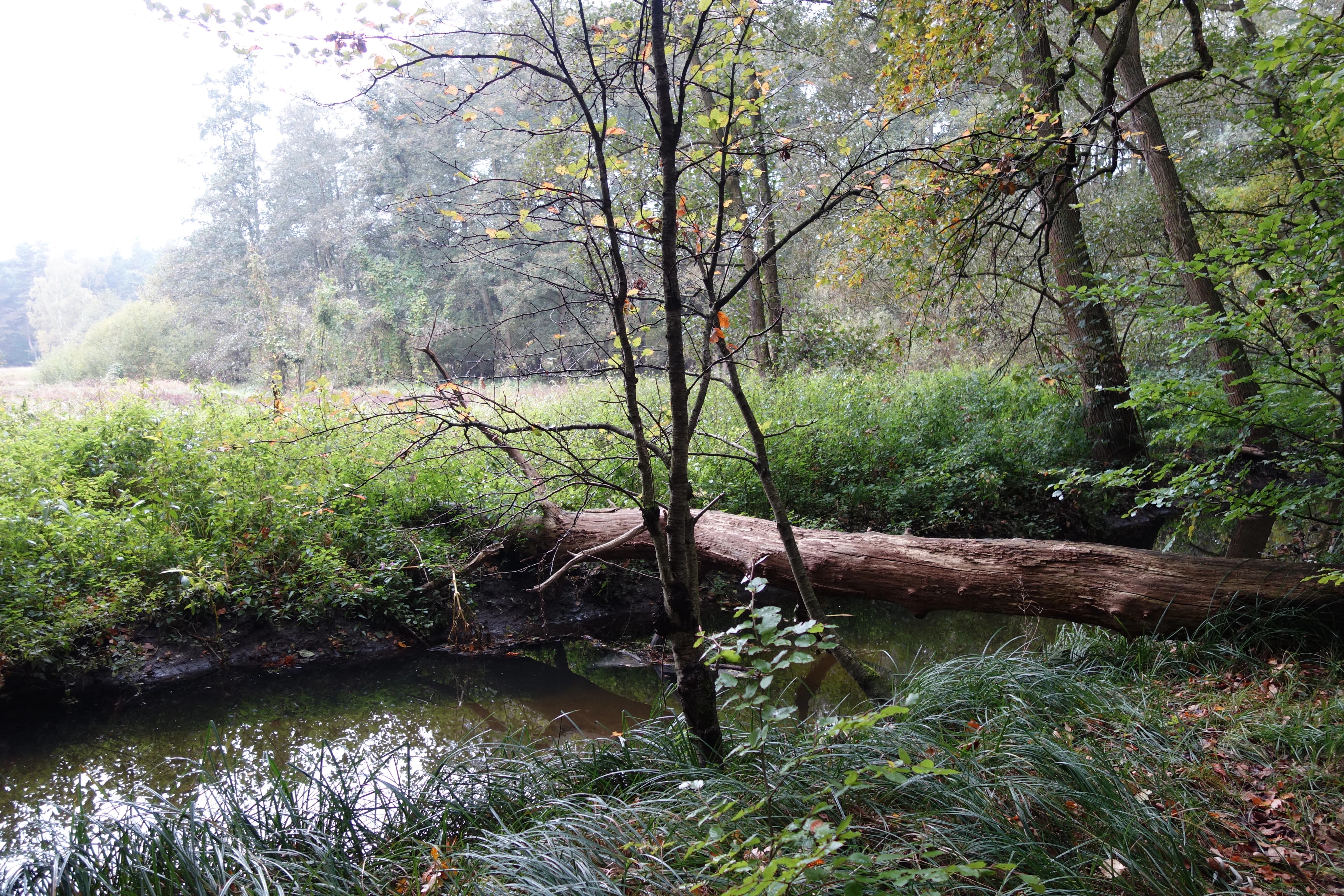
A small, calm stream winds through a lush, green forest with tall grasses and a fallen tree trunk resting across the water.
A tranquil stream flowing through the Erlensteg von Bieber nature reserve, with a fallen log spanning the water.

Erlensteg von Bieber history and protected-area timeline

Erlensteg von Bieber was placed under formal nature protection in March 1996, when the regional authorities established it as a Naturschutzgebiet under Hessian conservation law. The designation recognized the value of the area's mix of forest, meadow, and wetland habitats, and set out to preserve them against the increasing pressure of urban development in the Offenbach area. The formal ordinance governing the reserve was later revised and republished in February 1998. Since then, the site has remained under continuous protection, functioning as a stable refuge for the species and habitats for which it was originally designated.

Erlensteg von Bieber landscape and geographic character

The landscape of Erlensteg von Bieber is shaped primarily by the Bieber stream and the contrast between its moist floodplain surroundings and the drier, elevated ground nearby. Along the stream corridor, low-lying damp meadows and sedge-dominated wetland vegetation reflect the influence of shallow groundwater and periodic saturation, creating conditions associated with lowmoor plant communities. These wetter zones are edged by woodland stands that cover the majority of the reserve.

Away from the stream, the terrain transitions into drier sections that support both woodland and open fallow land on poorer soils. Open clearings within the forest let light reach the ground, producing the bright, herb-rich glades illustrated in photographs of the reserve. Small-scale variation between shaded woodland, sunlit clearings, damp meadows, and dry fallow fields gives the terrain a strongly patchwork character. Although the elevation differences across the reserve are modest, the resulting habitat diversity is unusually pronounced for a site of this size.

Erlensteg von Bieber ecosystems, habitats, and plant life

Erlensteg von Bieber protects an unusually concentrated variety of habitat types for a small site near a major German city. Wet meadows form one of the core habitats, supporting plants adapted to periodically saturated soils and lowmoor conditions. Sedge-dominated communities and other wetland plants thrive in these areas, while surrounding drier zones support rare central European forest types and Brachflächen, fallow lands that have been allowed to develop without intensive cultivation. Together, these habitats form a network of microhabitats that support a wide range of plant and animal species.

The habitat mosaic is ecologically significant because of the close interaction between wet and dry environments. Woodland cover dominates, contributing to a stable microclimate and supporting shade-tolerant plant species, while open meadows and clearings add light and warmth necessary for meadow and dryland specialists. The combination of structurally diverse vegetation layers, hydrological variation along the Bieber stream, and continuously managed yet low-intensity land use creates an ecological setting that contrasts sharply with the surrounding urban matrix.

Erlensteg von Bieber wildlife and species highlights

The wildlife profile of Erlensteg von Bieber follows directly from its habitat diversity. Wet meadow and sedge zones support invertebrates and amphibians that depend on damp conditions, while the surrounding forest provides habitat for woodland birds, small mammals, and other forest-associated fauna. The mix of open meadows, fallow land, and shaded woodland also supports pollinators and other insects that benefit from the combination of floral resources and sheltered nesting sites. Although detailed species inventories are not part of the primary source material, the site's habitat composition suggests meaningful value for typical meadow, wetland, and forest faunas of the Rhine-Main region.

Erlensteg von Bieber conservation status and protection priorities

From a conservation perspective, Erlensteg von Bieber is significant as a formally protected urban-adjacent nature reserve that maintains habitat types increasingly rare in heavily populated parts of Hesse. Its classification under IUCN Category IV as a Habitat/Species Management Area reflects a management-oriented approach, focused on preserving particular habitats and the species they support rather than allowing unrestricted ecological processes. The combination of wet meadows, rare forest communities, and fallow land on dry sites gives the reserve an outsized conservation role relative to its modest size.

Protection since 1996 has helped shield the area from the kind of urban expansion affecting much of the surrounding region, allowing its habitat diversity to persist. Continued extensive management of hay meadows, in particular, is essential for maintaining the open meadow communities on which species such as the broad-leaved marsh orchid depend. The reserve thus serves both as a refuge for native biodiversity and as a working example of small-scale, management-based nature conservation in an urban setting.

Erlensteg von Bieber cultural meaning and human context

The wider cultural context of Erlensteg von Bieber is tied to the agricultural and traditional land use patterns that shaped the Bieber district before it became part of the growing city of Offenbach am Main. The continued, low-intensity mowing of hay meadows within the reserve reflects the older rural land management traditions of the area, in which small fields and wet meadows along local streams played a central role. Maintaining these practices as part of the reserve's conservation approach links modern habitat protection with the longstanding human relationship to the Bieber stream and its floodplain.

Top sights and standout views in Erlensteg von Bieber

Erlensteg von Bieber stands out for packing several genuinely different habitat types into a very small urban-adjacent footprint, including wet meadows, sedge and lowmoor vegetation, rare forest communities, and dry fallow land. Its long protection history, dating back to 1996, and its IUCN Category IV designation point to a deliberate focus on habitat and species management. The presence of meadow species such as the broad-leaved marsh orchid underlines the botanical importance of its traditionally managed damp grasslands.

Best time to visit Erlensteg von Bieber

Erlensteg von Bieber can be enjoyed in any season, but late spring and early summer are particularly rewarding for observing the reserve's meadow flora, when the wet meadows supporting the broad-leaved marsh orchid are at peak bloom. Early morning or late daylight hours tend to favor encounters with woodland and meadow wildlife, and the cool, damp conditions of the stream corridor make summer visits comfortable within the wooded portions of the reserve.

Monthly climate preview

Long-term representative point measurements tracking monthly averages across Hessen

Erlensteg von Bieber Climate Normals, Annual Temperature and Precipitation Rhythm

Recorded baseline data captures multi-year temperature swings and precipitation rates across twelve distinct intervals at Erlensteg von Bieber. Detailed monthly climate records reveal full temperature extremes and precipitation averages for deeper geographic comparison.
Annual mean10 °C
0 °C21 °C
Jan
Feb
Mar
Apr10°
May14°
Jun18°
Jul21°
Aug20°
Sep15°
Oct10°
Nov
Dec
Warmest month
July

20.6 °C

Coolest month
January

0.2 °C

Wettest month
July

2.2 mm/day

Driest month
April

1.4 mm/day

Park location guide

Geography guide, regional context, and park location map for Erlensteg von Bieber

Erlensteg von Bieber park geography, regions, and map view in Germany

Understand where Erlensteg von Bieber sits in Germany through a broader geographic reading of the surrounding landscape, nearby location context, and its mapped position within the national park landscape.

How Erlensteg von Bieber fits into Germany

Germany is a federal republic in Western and Central Europe with a population of over 83 million across sixteen constituent states. It is Europe's largest economy by nominal GDP and a major global exporter and importer. The capital is Berlin, and the country borders Denmark, Poland, Czech Republic, Austria, Switzerland, France, Luxembourg, Belgium, and the Netherlands.

Wider geography shaping Erlensteg von Bieber in Germany

Germany is located in Western and Central Europe, spanning 357,022 km². It borders Denmark to the north, Poland and the Czech Republic to the east, Austria and Switzerland to the south, and France, Luxembourg, Belgium, and the Netherlands to the west. The country has coastlines on the Baltic Sea and North Sea to the north, with the Alps located in the southern region.

Map view of Erlensteg von Bieber

Use this park location map to pinpoint Erlensteg von Bieber in Germany, understand its exact geographic position, and read its mapped placement within the surrounding landscape more clearly.

Pigeon | © OpenStreetMap contributors

Location context for Erlensteg von Bieber

Hessen

Visualizing the diverse habitats, terrain, and stream environments of Erlensteg von Bieber

Erlensteg von Bieber Photos and Protected Landscape Scenery

Visual records illustrate the complex mosaic of damp meadows, sedge wetlands, and woodland environments across Erlensteg von Bieber. Examining these protected area photographs provides direct insight into the botanical diversity and unique topography defining the reserve.

A small, calm stream winds through a lush, green forest with tall grasses and a fallen tree trunk resting across the water.

Park atlas

Compare nearby regional reserves and connected protected landscapes in Hesse

Explore Parks Near Erlensteg von Bieber and Surrounding Protected Areas

Browsing other protected areas near Erlensteg von Bieber reveals broader ecological patterns across the surrounding Rhine-Main region. Comparing these nearby nature reserves provides deeper context on regional wetland habitats and woodland conservation.
Nature reserveHesse
About 3.8 km away#1 closest

East

Im Woog von Hainstadt Nature Reserve: Regional Geography and Protected Landscape Atlas

Mapping floodplain habitats in the Lower Main plain of Hesse

Im Woog von Hainstadt is a structurally diverse nature reserve located in Hainstadt, Germany. The site protects a compact floodplain mosaic consisting of deciduous woodland, wet meadows, and dry grasslands on a former river meander. Adjacent to the Wildpark Alte Fasanerie, the reserve functions as a biodiversity hotspot, offering essential habitat within the developed eastern Lower Main plain landscape.

Area
0.142 km²
Established
1992
Relief
Lowland
Climate
Temperate
A horizontal watercolor painting depicting a landscape with calm water, grassy marshlands, and distant rolling hills in soft pastel colors.
Nature reserveHessen
About 4.3 km away#2 closest

South

Nachtweide von Patershausen: Nature Reserve Geography and Mapped Protected Boundaries

Protected landscape and habitat atlas for the Hessen region

Nachtweide von Patershausen stands as a vital nature reserve in Hessen, characterized by a textured cultural landscape that includes rare nutrient-poor grassland and historical carp ponds. This protected site offers significant insight into the regional ecology of the Rhine-Main area, providing a dense mosaic of habitats that anchor the local natural environment near Heusenstamm.

Area
0.178 km²
Established
1987
IUCN
IV
Nature reserveHessen
About 4.9 km away#3 closest

Southwest

Luderbachaue von Dreieich: A Protected Floodplain Forest and Habitat in Hessen, Germany

Mapping the ecological geography of a significant lowland nature reserve

Spanning over 290 hectares, Luderbachaue von Dreieich serves as a major protected floodplain forest. The site preserves a diverse mosaic of oak, beech, and alder-ash woodlands that sustain rare fungal communities and old-growth timber, maintaining a vital green corridor in the urbanized Rhine-Main region.

Area
2.938 km²
Established
1996
IUCN
IV
Relief
Lowland
A wide watercolor illustration depicting a green wetland landscape with reed beds, grasses, and distant hills under a pale sky.
Nature reserveHessen
About 5 km away#4 closest

East

Gräbenwäldchesfeld von Hausen: Nature Reserve and Protected Wetland Landscape Geography

Mapping rare meadow ecosystems in the Hessen region

Gräbenwäldchesfeld von Hausen functions as a critical protected nature reserve, safeguarding species-rich wet meadows and moisture-dependent flora in the town of Obertshausen. This atlas entry details the site's role within the Landkreis Offenbach, focusing on the preservation of reed beds and marsh landscapes amidst a predominantly urbanized terrain.

Area
0.054 km²
Established
1990
IUCN
IV
Relief
Lowland
Nature reserveHessen
About 5.1 km away#5 closest

West

Bruch von Gravenbruch Nature Reserve: Geographic Profile and Protected Wetland Mapping

Hessen lowland moor and wetland habitat analysis

Examine the detailed terrain of Bruch von Gravenbruch, a notable nature reserve in Hessen characterized by its high groundwater table and intricate moisture-dependent ecosystems. The area serves as a key reference for studying lowland moor development, bog woodland structure, and the spatial distribution of protected wetland meadows across the regional landscape.

Area
0.932 km²
Established
1984
IUCN
IV
Nature reserveLandkreis Offenbach
About 5.2 km away#6 closest

Northeast

Mayengewann von Lämmerspiel: Nature Reserve and Protected Landscape in Landkreis Offenbach

Oak woodlands and rare orchid meadows within the Rhine-Main landscape

Examine the geography of Mayengewann von Lämmerspiel, a significant nature reserve characterized by its mosaic of old oak forest and moist grassland. This site acts as an ecological refuge in Landkreis Offenbach, safeguarding rare species such as the fen violet, adder's-tongue fern, and multiple orchid varieties within a carefully managed protected boundary.

Area
0.067 km²
Established
1985
IUCN
IV
Relief
Lowland
Watercolor illustration of a soft rolling landscape with grassy fields, scattered trees, and rolling hills in shades of green and yellow.
Nature reserveHessen
About 6.5 km away#7 closest

Northeast

Amerikafeld und Schindkaute bei Steinheim: Nature Reserve and Protected Grassland Map

Rare sand dry grassland habitat within the Hessen metropolitan region.

Amerikafeld und Schindkaute bei Steinheim is a protected nature reserve in Hanau that shelters scarce sand dry grasslands. The terrain, defined by ice-age sandy deposits, remains an important ecological island, maintaining an open steppe-like character through historic grazing practices in a landscape otherwise dominated by urban growth.

Area
16 km²
Established
1995
A horizontal watercolor painting showing a stylized, layered forest scene in muted green, pink, and yellow tones on a white background.
Nature reserveHesse
About 6.6 km away#8 closest

Northeast

Lauternsee bei Klein-Auheim Nature Reserve: Geography and Protected Bog Landscape

A historic high terrace habitat within the Hesse woodland region.

Lauternsee bei Klein-Auheim represents a specialized Flachmoor habitat that emerged from a former river channel of the Main. This nature reserve serves as an important ecological anchor in the lower Main valley, protecting essential wetlands, amphibian populations, and unique marsh plant communities within an expansive forest setting.

Established
1987

Common questions about visiting, size, designation, and location context for Erlensteg von Bieber

Erlensteg von Bieber FAQs for park facts, access, geography, and protected area context

Find quick answers about Erlensteg von Bieber, including protected-area facts, park geography, trail and visitor context, and how the park fits into its surrounding country and regional landscape.
MoriAtlas Explorer

Continue Your Protected Areas Search Across the Global Atlas

Deepen your exploration by continuing the structured search for national parks and protected areas worldwide. Utilize the comprehensive filtering capabilities to compare different conservation landscapes and refine your understanding of global park geography. Discover more about the distribution and characteristics of protected natural areas.

Global natural geography