
Mori Atlas logo
Nature reserveErnstberg

A detailed look at the stratovolcano structure and protected forest landscape in Rhineland-Palatinate

Ernstberg Nature Reserve: Geological Mapping of the West Eifel Volcanic Field

Ernstberg stands as the highest peak of the West Eifel volcanic field, representing a significant stratovolcano defined by its eastward-opening crater wall and basalt lava flows. This nature reserve in Rhineland-Palatinate preserves historical millstone quarries, rocky outcrops like the Martinswand, and diverse forest habitats that are monitored under European conservation standards. Discover the geological terrain and protected boundaries of this prominent natural monument through detailed map-based insights.

Eifel mountainsvolcanic landscapestratovolcanobasaltWest Eifel volcanic fieldVulkaneifel
A flat-design digital illustration showing a winding river through a valley with a waterfall cascading down a cliffside, framed by pine trees in the foreground and rounded mountains in the background under a soft sky.

Ernstberg

Nature reserve

Park overview

Structured park overview, official facts, and landscape profile for Ernstberg

Ernstberg park facts, protected area profile, and essential visitor context

Review the core facts for Ernstberg, including designation, size, terrain, visitor scale, habitats, and operating context in one park-focused overview.

About Ernstberg

Ernstberg is a prominent forested peak in the Eifel mountains of western Germany, rising to 701.4 m above sea level near the village of Hinterweiler in the Landkreis Vulkaneifel, Rhineland-Palatinate. Though it is not the highest mountain in the Eifel overall, that distinction belongs to the Hohe Acht at 746.9 m, Ernstberg is the tallest of the West Eifel volcanoes, a distinction that places it at the heart of one of Central Europe's most important Quaternary volcanic fields, the Vulkaneifel.

The mountain belongs to the Vulkaneifel Nature Park and forms one of the protected-area cornerstones of this geologically rich region. Its setting is characteristic of the Eifel highlands: rounded, heavily forested ridges punctuated by volcanic cones, maars, and scattered basalt outcrops. Surrounding settlements include Dockweiler to the north-northeast, Waldkönigen to the east, Steinborn to the south-southeast, and Kirchweiler to the west, all small communities that share the mountain's forested backdrop.

What distinguishes Ernstberg from neighboring peaks is its clearly preserved volcanic anatomy. The summit is built from welded volcanic slag forming a crater wall that opens to the east, while basalt lava flowed down the eastern flank in a broad semicircle that is still visible today. The mountain's geological value has been formally recognized for decades: the summit has been protected as a natural monument since 1938, and a 96 ha nature reserve covering most of the mountain was designated in 1978. As a result, Ernstberg is not just a scenic landmark but a protected geological monument within the Vulkaneifel landscape.

Quick facts and research context for Ernstberg

Ernstberg is situated in the central Vulkaneifel Nature Park in Rhineland-Palatinate, Germany, within the municipality of Hinterweiler. It reaches 701.4 m above sea level and belongs to the Eifel mountain range.

Geologically, Ernstberg is an Early Pleistocene stratovolcano, with summit deposits of welded slag and eastern flank basalt flows of nepheline leucitite. A 96 ha nature reserve has covered most of the mountain since 1978, and its summit has been a natural monument since 1938. The Ernstberg also falls partly within a large landscape protection area and the Gerolsteiner Kalkeifel FFH (Fauna-Flora-Habitat) site.

Protection and recognition

Analysis of terrestrial boundaries, designation year, and official recognition records

Ernstberg Protection Status and Documented Conservation History

Ernstberg maintains a terrestrial protection status established in 1978 within international database records. Structured records track management scope and conservation history without assuming external recognition programmes.

Protection details

Protection scope
Terrestrial
Designated year
1978
Transboundary protection
No
WDPA ID
81623
Park context

Deeper park guide and search-rich context for Ernstberg

Ernstberg history, landscape, wildlife, and travel context

Explore Ernstberg through its history, landscape character, ecosystems, wildlife, conservation priorities, cultural context, and seasonal travel timing in a structured park guide built for atlas discovery and search intent.

Why Ernstberg stands out

Ernstberg is known above all as the highest volcano of the West Eifel volcanic field, a textbook example of an Early Pleistocene stratovolcano with a ring-shaped arrangement of welded slag and basalt (nepheline leucitite) deposits. Its eastward-opening crater wall and the basalt flows that descended the eastern slope give the mountain a clearly recognizable volcanic profile. The second defining feature is its protected status: a dedicated nature reserve, a long-standing natural monument covering the summit, and inclusion in a European Fauna-Flora-Habitat area all underline its geological and ecological importance. A scenic cave passes through the mountain just below the summit, and the rocky Martinswand on its southeastern flank is a further notable landmark.
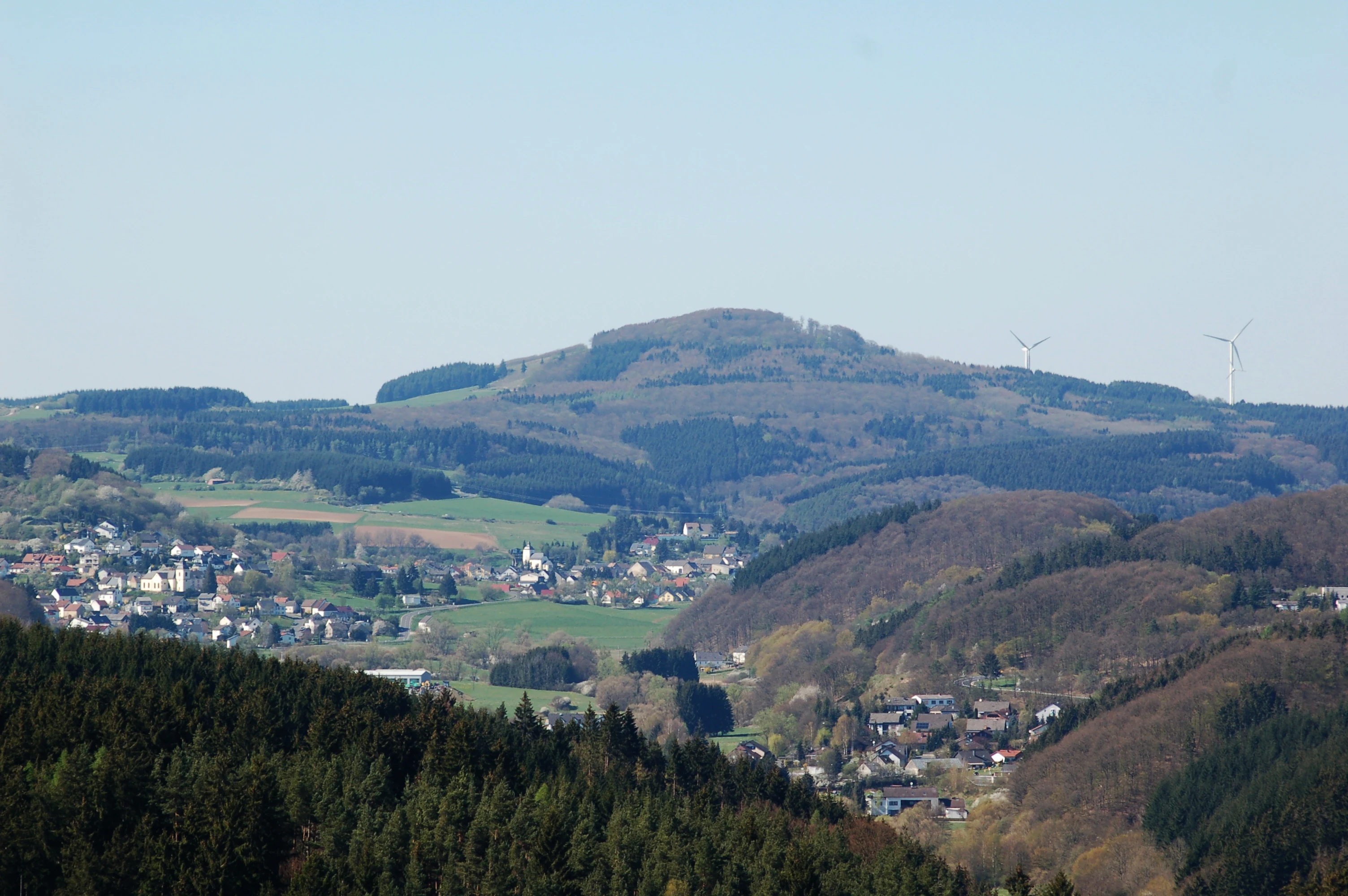
A wide shot of a rolling, forested volcanic hill with small towns and green fields in the valley below under a clear sky.
A view of the Ernstberg volcanic peak overlooking the rural Eifel landscape.

Ernstberg history and protected-area timeline

Ernstberg's modern history is closely tied to scientific recognition of its volcanic origin and to a layered sequence of formal protection. The summit has been designated as a natural monument since 16 April 1938, with the explicit purpose of preserving the stratovolcano as a geological feature. This early protection makes Ernstberg one of the longer-standing geological monuments in the Eifel region.

A broader Ernstberg nature reserve was then established on 20 September 1978 by the Bezirksregierung Trier, covering 96 hectares across most of the mountain. In 1982, the surrounding landscape, including parts of the Ernstberg, was incorporated into the landscape protection area Zwischen Üß und Küll, a 396.32 km² protected zone. At the European level, the mountain also lies partly within the Gerolsteiner Kalkeifel Fauna-Flora-Habitat site, registered as FFH area 5706-303, covering 84.08 km².

Long before any modern conservation designation, the basalt at the foot of Ernstberg was quarried for millstones from the Middle Ages until approximately 1930, leaving a small but lasting mark on the mountain's lower slopes. An old stone cross near the summit also commemorates the extreme winter of 1783/84, a reminder that this now-protected landscape has long been part of local memory and rural life.

Ernstberg landscape and geographic character

Ernstberg's profile is unmistakably volcanic. The summit cone consists of welded volcanic slag arranged into a crater wall that is open toward the east, and from this opening basalt lava flowed out during the Early Pleistocene. These flows created a distinctive semicircular basalt mass along the eastern flank, still evident in the terrain today.

Lower on the mountain, the remains of medieval and early modern millstone quarries mark the foot of the eastern face, where basalt was historically extracted. On the southeastern flank lies the Martinswand, a rocky outcrop that adds vertical structure to the otherwise rounded, forest-covered slopes. Just below the summit, a cave passes through the mountain from one side to the other, although its entrances are blocked and cannot be entered.

The wider landscape fits the classic Vulkaneifel pattern: alternating ridges, volcanic cones, and forested valleys threaded with small villages. Ernstberg sits near maars such as the Weinfelder Maar, visible from the nearby Mäuseberg, integrating the peak into a region shaped by explosive volcanic and phreatomagmatic activity.

Ernstberg ecosystems, habitats, and plant life

Although Ernstberg's geological story is its primary draw, its flora is also notable. The mountain is forested, and the woodland habitat supports stands of perennial honesty, known scientifically as Lunaria rediviva and referred to in German as Mondviolen. The presence of this species reflects the moist, sheltered conditions found in parts of the Eifel forest understorey and contributes to the botanical interest of the protected area.

The Ernstberg nature reserve and the broader landscape protection area and FFH zone that include the mountain together recognize the value of these mixed deciduous and coniferous forest stands, as well as the rocky and cliff microhabitats along the Martinswand. Older juniper areas, characteristic of the region, also occur nearby in the Vulkaneifel, although the Ernstberg's own contribution is more strongly shaped by its upland forest cover and basalt-derived soils.

Ernstberg conservation status and protection priorities

Ernstberg's conservation profile is unusually layered for a single mountain, reflecting both geological and ecological values. The summit has been protected as a natural monument since 1938, with the formal aim of preserving the stratovolcano itself. Almost the whole of the mountain was additionally designated as the Ernstberg nature reserve in 1978, covering 96 hectares.

The mountain also lies partly within the large landscape protection area Zwischen Üß und Küll, designated in 1982, and partly within the Gerolsteiner Kalkeifel Fauna-Flora-Habitat site, a European-level conservation designation covering 84.08 km². Together these designations place Ernstberg at the intersection of German natural monument, nature reserve, landscape protection, and EU Habitats Directive protections, making it one of the more comprehensively protected volcanic landforms in the Eifel.

Ernstberg cultural meaning and human context

Ernstberg's human history is subtle but persistent. The basalt at the mountain's foot was quarried for millstones from the Middle Ages through to about 1930, reflecting a long tradition of using local volcanic rock for grinding grain in the Eifel hill communities.

An old stone cross preserved near the Ernstberg commemorates the extreme winter of 1783/84, marking the mountain as part of local memory and rural commemoration. The surrounding villages, Hinterweiler, Dockweiler, Waldkönigen, Steinborn, and Kirchweiler, all belong to the small-scale agricultural and forestry culture of the Vulkaneifel, where the mountain is both a working forest landscape and a shared local landmark.

Top sights and standout views in Ernstberg

Ernstberg combines clear volcanic geology with extensive formal protection in a single forested Eifel peak. The summit crater wall open to the east, the semicircular basalt flow on the eastern flank, the historic millstone quarries at the foot of the mountain, and the rocky Martinswand on the southeastern flank together form a compact, walkable geological showcase.

Layered conservation designations, ranging from a 1938 natural monument to a 1978 nature reserve and a European FFH site, underline the mountain's standing as one of the most formally protected volcanic features in the Vulkaneifel. Its proximity to other Vulkaneifel landmarks, including the Weinfelder Maar and other West Eifel volcanic features, makes Ernstberg a natural focal point for anyone exploring the geodiversity of the Eifel.

Best time to visit Ernstberg

Ernstberg is a forested mountain whose character shifts with the seasons rather than with major weather extremes. Spring and early summer bring fresh leaf cover to the deciduous woodland and a chance to see characteristic forest wildflowers in bloom, including the perennial honesty that grows in shaded parts of the slope. Summer hiking is straightforward along the surrounding forest paths and farm roads.

In winter, the elevation of Ernstberg often allows for cross-country skiing on prepared trails, sledding on dedicated slopes, and use of the local ski rental hut, conditions that are not guaranteed every year but recur frequently enough to make the mountain a recognized winter sports venue in the Vulkaneifel. Shoulder seasons are quieter and well suited to appreciating the volcanic landforms without snow cover.

Monthly climate preview

Long-term representative monthly averages and temperature spans for Ernstberg

Ernstberg Climate Normals, Annual Temperature and Precipitation Rhythm

Historical data records the annual temperature and precipitation rhythm across measured representative coordinates in Ernstberg. Examining the complete monthly climate normals reveals detailed patterns in average temperatures and precipitation amounts.
Annual mean9 °C
0 °C18 °C
Jan
Feb
Mar
Apr
May12°
Jun16°
Jul18°
Aug18°
Sep14°
Oct
Nov
Dec
Warmest month
July

18.2 °C

Coolest month
January

-0.3 °C

Wettest month
December

2.5 mm/day

Driest month
April

1.6 mm/day

Park location guide

Geography guide, regional context, and park location map for Ernstberg

Ernstberg park geography, regions, and map view in Germany

Understand where Ernstberg sits in Germany through a broader geographic reading of the surrounding landscape, nearby location context, and its mapped position within the national park landscape.

How Ernstberg fits into Germany

Germany is a federal republic in Western and Central Europe with a population of over 83 million across sixteen constituent states. It is Europe's largest economy by nominal GDP and a major global exporter and importer. The capital is Berlin, and the country borders Denmark, Poland, Czech Republic, Austria, Switzerland, France, Luxembourg, Belgium, and the Netherlands.

Wider geography shaping Ernstberg in Germany

Germany is located in Western and Central Europe, spanning 357,022 km². It borders Denmark to the north, Poland and the Czech Republic to the east, Austria and Switzerland to the south, and France, Luxembourg, Belgium, and the Netherlands to the west. The country has coastlines on the Baltic Sea and North Sea to the north, with the Alps located in the southern region.

Map view of Ernstberg

Use this park location map to pinpoint Ernstberg in Germany, understand its exact geographic position, and read its mapped placement within the surrounding landscape more clearly.

Pigeon | © OpenStreetMap contributors

Location context for Ernstberg

Rhineland-Palatinate

Explore detailed imagery of protected forest habitats, basalt terrain, and geological formations across Ernstberg.

Ernstberg Photos and Volcanic Landscape Scenery: Visualizing the Highest Peak of the West Eifel Volcanic Field

Visual documentation captures the rugged basalt terrain, forested slopes, and distinct volcanic geology defining Ernstberg. Examining these protected area photographs reveals the topography, ecological habitats, and conservation landscape more clearly.

A wide shot of a rolling, forested volcanic hill with small towns and green fields in the valley below under a clear sky.

A weathered dark stone cross with faint engraved numbers standing in a snow-covered field with an icicle hanging from the top left corner, set against a wire fence background.

Park atlas

Compare adjacent volcanic terrain and connected regional conservation areas

Exploring Parks Near Ernstberg and Surrounding Vulkaneifel Protected Landscapes

Browse other parks near Ernstberg to examine related volcanic formations and protected forest ecosystems across the wider region. Continuing the comparison reveals how neighboring geological monuments and nature reserves share the distinctive topography of the Eifel range.
Watercolor painting depicting gentle, rolling hills covered in light green forest, with a soft horizon line and pale foreground.
Nature reserveRhineland-Palatinate
About 4.1 km away#1 closest

South

Nerother Kopf: Volcanic Cinder Cone Landscape and Nature Reserve in Rhineland-Palatinate

Geological and protected woodland study in the German Eifel

Investigate the volcanic terrain of Nerother Kopf, a double cinder cone landmark in Rhineland-Palatinate. This nature reserve provides essential insights into Eifel geology, featuring a combination of protected beech forest, historical castle ruins, and visible basalt quarrying.

Relief
Mountain
Climate
Temperate
Access
Easy access
Scope
Terrestrial
A horizontal watercolor painting showing a soft, stylized landscape with rolling green hills, a winding path or stream, and a few trees on a white background.
Nature reserveRhineland-Palatinate
About 14 km away#2 closest

Southeast

Dürres Maar Nature Reserve: Mapped Volcanic Landscapes and Peatland Geography

A dry volcanic crater and transition bog in the Eifel.

Dürres Maar represents a quintessential dry maar landform defined by a circular tuff rim and a matured peat basin. Situated near Gillenfeld, the site acts as a geological monument and ecological record of long-term mire succession. Explore the map-based terrain and crater boundaries to understand how this volcanic remnant functions within the Vulkaneifel.

Relief
Upland
Climate
Temperate
Water
Major water bodies
A horizontal watercolor painting depicting a calm lake surrounded by rolling hills and soft greenery, with a purple-toned ridgeline in the distance.
Nature reserveRheinland-Pfalz
About 14 km away#3 closest

South

Meerfelder Maar Nature Reserve: Volcanic Basin and Protected Eifel Landscape Mapping

Detailed volcanic crater geography and lake basin analysis

Discover the geological structure and protected habitats of Meerfelder Maar. This classic Eifel crater lake spans roughly 125 hectares, combining open water with fringing wetlands and forested slopes to create a unique natural landmark in Rheinland-Pfalz.

Area
2.6 km²
Established
1985
IUCN
IV
Relief
Upland
A soft, painterly watercolor illustration depicting a calm lake framed by evergreen trees and rolling green hills.
Nature reserveRhineland-Palatinate
About 15 km away#4 closest

Southeast

Holzmaar Nature Reserve: Volcanic Crater Geography and Sediment Archive in Germany

A forest-enclosed maar lake in the Vulkaneifel region.

Holzmaar represents a significant volcanic maar site within Rhineland-Palatinate, defined by its circular basin, wetland-rich margins, and stream-fed hydrology. Recognized as a critical reference for paleoclimate research, its laminated sediment layers provide a detailed look at late-glacial European environmental history.

Area
0.068 km²
Relief
Upland
Climate
Temperate
Scope
Terrestrial
Protected areaRheinland-Pfalz
About 15 km away#5 closest

East

Ulmener Maar Protected Area: Mapping Crater Lakes and Eifel Volcanic History

Volcanic maar, medieval ruins, and meromictic lake geography

Ulmener Maar provides a rare glimpse into the volcanic evolution of the Eifel region. This protected area centers on a deep, meromictic crater lake cradled by a forested tuff ring, connected via historical tunnels to the older Jungferweiher maar. It serves as a vital point for understanding the interplay between geological youth and centuries of human settlement in Germany.

Nature reserveNorth Rhine-Westphalia
About 17 km away#6 closest

North

Vogelschutzgebiet Ahrgebirge Nature Reserve, North Rhine-Westphalia Protected Landscape

Mapped ridge terrain and woodland habitat in the western Eifel region

The Vogelschutzgebiet Ahrgebirge serves as a significant nature reserve protecting the North Rhine-Westphalian side of the Ahrgebirge ridge. Its geography consists of dense, near-natural deciduous forests, stream-cut valleys, and deadwood habitats that provide breeding ground for specialist avian species, forming part of a larger interconnected network across the Rhenish Slate Mountains.

Area
5.8 km²
Established
2004
Nature reserveRheinland-Pfalz
About 17 km away#7 closest

Northeast

Quiddelbacher Höhe / Nürburgring Nature Reserve: A Protected Highland Plateau in the Eifel

Explore the regional geography and conservation landscape of Rheinland-Pfalz

Quiddelbacher Höhe / Nürburgring protects a distinct highland plateau surface known for its rare vegetation and critical role in local ecological conservation. Situated near major transit corridors and the famous racing circuit, the site provides a quiet, open landscape contrast within the larger Ahrweiler region of Germany.

Area
0.27 km²
Established
2002
Relief
Upland
Climate
Temperate
A horizontal watercolor illustration showing soft, rolling green hills, a background of distant purple mountains, and small clusters of pinkish trees.
Nature reserveNorth Rhine-Westphalia
About 17 km away#8 closest

North

Lampertstal und Alendorfer Kalktriften mit Fuhrbach und Mackental: Eifel Protected Landscapes

A diverse nature reserve in North Rhine-Westphalia featuring karst geography

This extensive nature reserve in the Eifel region serves as a crucial habitat for limestone flora, featuring the largest juniper conservation site in North Rhine-Westphalia. Spanning a complex of valleys and hills, the area demonstrates a distinctive interaction between karst geology, medieval historical sites, and rare calcareous ecosystems that support a wide range of protected species.

Area
11.01 km²
Established
2007
Relief
Upland
Climate
Temperate

Common questions about visiting, size, designation, and location context for Ernstberg

Ernstberg FAQs for park facts, access, geography, and protected area context

Find quick answers about Ernstberg, including protected-area facts, park geography, trail and visitor context, and how the park fits into its surrounding country and regional landscape.
MoriAtlas Explorer

Continue Your Protected Areas Search Across the Global Atlas

Deepen your exploration by continuing the structured search for national parks and protected areas worldwide. Utilize the comprehensive filtering capabilities to compare different conservation landscapes and refine your understanding of global park geography. Discover more about the distribution and characteristics of protected natural areas.

Global natural geography