
Mori Atlas logo
Protected landscapeFahner Höhe

Analyzing the forest terrain, geological block formation, and ecological boundaries of a central German landscape

Fahner Höhe: A Comprehensive Geographic Overview of the Protected Muschelkalk Ridge in Thuringia

Fahner Höhe rises as a prominent forested ridge within the Thuringian Basin, defining the regional topography with its narrow 12-kilometer Muschelkalk block. This protected landscape is shaped by upwarped limestone layers, creating a distinct climatic divide between humid northern slopes and warmer southern plains. The area supports extensive oak and hornbeam woodlands, serving as a critical corridor for rare flora and local recreation near Erfurt, Gotha, and Bad Langensalza.

deciduous forestoak-hornbeam woodlandMuschelkalk ridgeThuringian Basinlow mountain rangeforest recreation
Stylized digital illustration of a valley landscape with a waterfall, a stone tower, and a tree in the foreground, rendered in a flat, graphic style with soft colors.

Fahner Höhe

Protected landscape

Park overview

Structured park overview, official facts, and landscape profile for Fahner Höhe

Fahner Höhe park facts, protected area profile, and essential visitor context

Review the core facts for Fahner Höhe, including designation, size, terrain, visitor scale, habitats, and operating context in one park-focused overview.

About Fahner Höhe

Fahner Höhe lies in the heart of the Thuringian Basin, the broad lowland between the Harz mountains, the Thuringian Forest, and the Eichsfeld. Although surrounded by relatively flat farmland, it stands out as one of the tallest inner elevations of the basin, a long forested island of woodland that interrupts the agricultural plain. Its location between the cities of Erfurt, Gotha, and Bad Langensalza makes it both a regional landmark and a focal point for outdoor recreation in central Thuringia.

Geologically, the ridge was lifted by the deep-seated movement of Zechstein salt beneath the Muschelkalk limestone layers, producing a structural high that has since been eroded into a narrow, elongated ridge. The Upper Muschelkalk dominates the surface, while loess blankets the gentle northern foot, creating contrasts in soils, slope, and moisture.

Ecologically, the Fahner Höhe is defined by large, mature deciduous forests. Oak-hornbeam woods of different types cover most of the ridge, with beech communities favoring the cooler, shadier northern slopes. Notable forest patches include the Ballstädter Holz, the Im Haken oak forest near Witterda, and the Peterholz near Töttelstädt, the last of which includes elements of dry oak woodland. The ground flora includes the Siberian iris, healblümchen (hepatica), yellow aconite, and the locally abundant spring snowflake in the Blütengrund. These plant communities, together with the presence of rare sinkhole landforms, give the area notable conservation value, reflected in landscape protection status, individual nature reserves, and a Natura 2000 designation covering the western half.

Quick facts and research context for Fahner Höhe

Fahner Höhe is a forested ridge of about 26 square kilometers in the Thuringian Basin, located in the German state of Thuringia. Its highest point, the Abtsberg, reaches 413 meters above sea level, with the ridge crest generally lying between 300 and 413 meters. The feature extends roughly 12 kilometers in length and up to 4 kilometers in width, split between the rural districts of Gotha and Sömmerda and the city of Erfurt.

The rock is entirely Upper Muschelkalk limestone, underlain by Zechstein salt whose upward pressure created the elevation. Soil patterns include clay-rich Pelosole and Terra fusca as well as rendzinas on steeper slopes, with loess deposits thickening along the northern drop. Annual precipitation on the ridge reaches about 650 to 700 millimeters, noticeably higher than the dry basin below, and the northern slopes mark a watershed between the Elbe and Weser catchments.

Protection and recognition

Examine the documented protection framework and management scope for Fahner Höhe.

Fahner Höhe Protection Status and Terrestrial Conservation Data

Fahner Höhe maintains a defined terrestrial protection scope with structured conservation records and official administrative status. Review the verified governance metrics, regional designation history, and international recognition details for this protected natural area.

Protection details

Protection scope
Terrestrial
Transboundary protection
No
Park context

Deeper park guide and search-rich context for Fahner Höhe

Fahner Höhe history, landscape, wildlife, and travel context

Explore Fahner Höhe through its history, landscape character, ecosystems, wildlife, conservation priorities, cultural context, and seasonal travel timing in a structured park guide built for atlas discovery and search intent.

Why Fahner Höhe stands out

Fahner Höhe is best known as a prominent forested Inselberg rising from the otherwise flat Thuringian Basin. Its distinctive combination of extensive, in places centuries-old oak-hornbeam forests and rare woodland flowers such as the Siberian iris, cross gentian, and large carpets of spring snowflake sets it apart within central Thuringia. The ridge is also recognized for its geological character: a textbook example of an upwarped Muschelkalk block created by deep salt movement, with sinkholes, dry valleys, and a clear climatic divide between the shaded, humid northern slopes and the warmer, drier southern plains below.
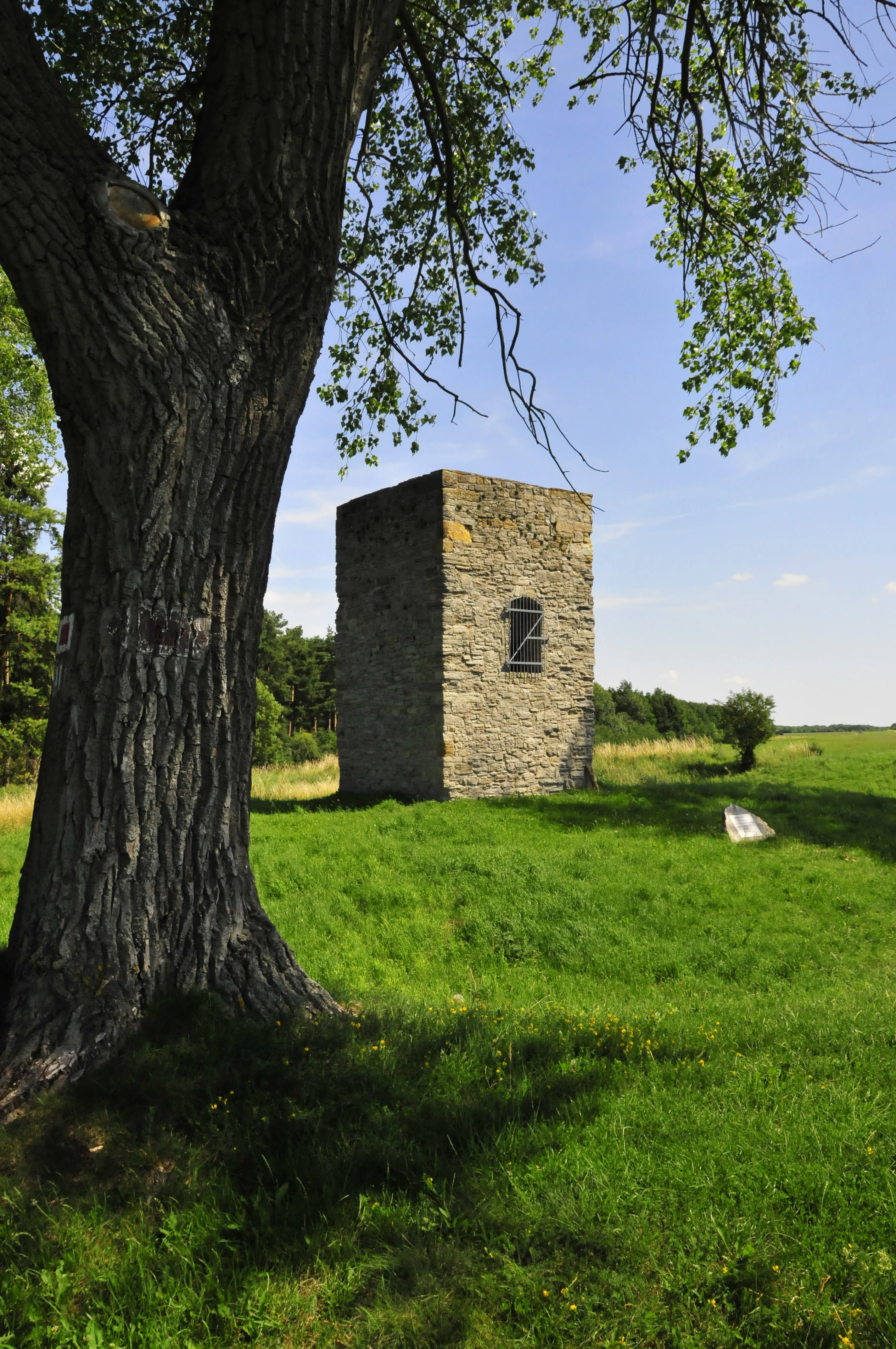
A stone watchtower with a metal-grated window stands in a grassy field next to a large tree under a clear blue sky.
The historic Bienstädter Warte watchtower stands in a field within the Fahner Höhe region.

Fahner Höhe history and protected-area timeline

The forests of the Fahner Höhe have been used for timber production for centuries, shaping their composition and structure to the present day. In 1411 the city of Erfurt built the Bienstädter Warte, a roughly 18-meter-tall watchtower, at one of the ridge's highest points; it remains one of the most recognized landmarks of the entire landscape.

During the closing days of the Second World War, on 9 April 1945, young Wehrmacht soldiers dug foxholes on the Abtsberg plateau at the western end of the ridge. They were engaged by an American scout tank of the 80th Cavalry Reconnaissance Troop; seven of the 17- and 18-year-olds were killed, and their small gravesite, the so-called Sieben Gräber, still exists on the mountain today. In the same area, more than fifty soldiers, German and American, lost their lives across that and the following day.

In the decades after the war, the area was repurposed for surveillance as well: a former gliding school of the GST near the Bienstädter Warte was converted after 1957 into a central listening station of the East German Ministry for State Security. More recently, in the early twenty-first century, one of Thuringia's first large open-field photovoltaic installations was built south of Ballstädt, signaling the ridge's growing role in the regional energy transition.

Fahner Höhe landscape and geographic character

The Fahner Höhe forms a long, narrow backbonelike ridge running from northwest to southeast across the floor of the Thuringian Basin. It is about 12 kilometers long and rarely more than 4 kilometers wide, tapering into a narrow southeastern spur. The crest generally lies between 300 and 413 meters above sea level, with the highest point, the Abtsberg, found at the western end. From the gently inclined southwestern side, which descends toward the Nesse valley, the ridge drops steeply to the northeast, producing a clear, visually striking contrast in the landscape.

The mountain rises roughly 250 meters above the surrounding basin floor and is visible from far across the plain. From the edges of the ridge, wide panoramas open over the Thuringian Basin, the distant Höhenzüge at its margins, and, on the southern horizon, the Thuringian Forest with the prominent Großer Inselsberg. Toward the northeast, gypsum-keuper hills such as the Schwellenburg rise like outriders in front of the main ridge.

Despite the prevalence of limestone, surface water is scarce. The Muschelkalk is heavily fractured and permeable, so most drainage occurs underground, and only a few streams form along the northern escarpment after heavy rain or snowmelt. The Imtalgraben, a deeply incised gorge-like valley between the Bienstädter Warte and Kleinfahner, is one of the most expressive erosional features of the ridge. At the Bienstädter Warte itself, the ridge forms the watershed between the Elbe and Weser river systems.
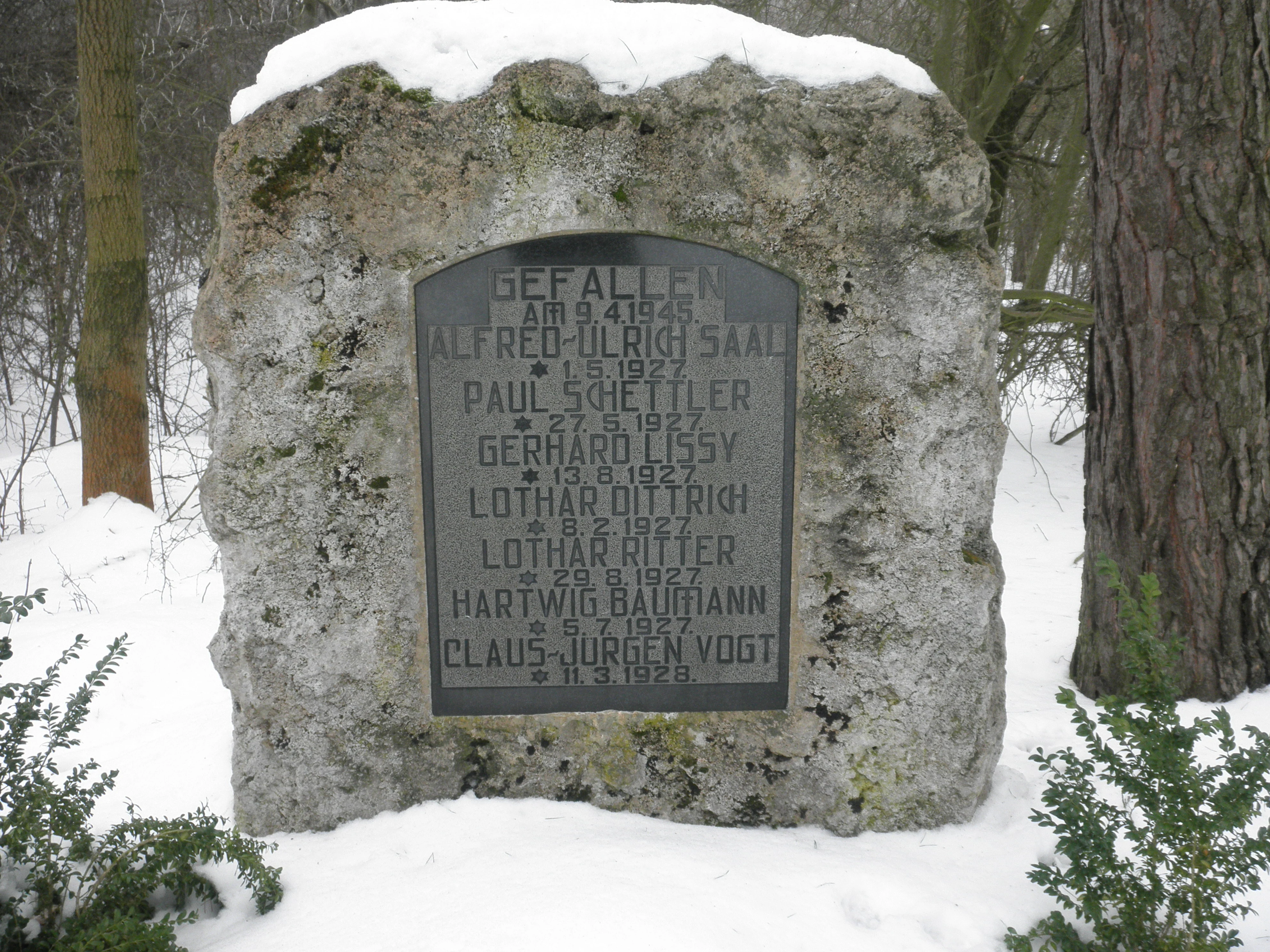
A weathered stone monument with an engraved dark plaque listing names and dates, surrounded by snow in a forested area.
A historical memorial stone, known as the Seven Graves, situated in the forested Fahner Hohe region.

Fahner Höhe ecosystems, habitats, and plant life

The dominant vegetation of the Fahner Höhe is forest. Extensive natural oak-hornbeam communities of several types cover much of the ridge, including bedstraw and meadowsweet variants. On the cooler, less sun-exposed northern slopes, beech woods of the woodruff type thrive. More demanding mixed broadleaf forests and gorge-like communities are rare, occurring mainly in the Imtal, in sinkholes, and at the foot of the northern escarpment.

Particularly impressive old oak stands include the Ballstädter Holz to the west, the Im Haken oak forest near Witterda, and the Peterholz near Töttelstädt. In the Peterholz, transitions to dry oak woodland with small, gnarled oaks under 20 meters tall can be found. Many of these forests have a strong understory of spiny shrubs such as blackthorn and hawthorn, which limits natural oak regeneration. A distinctive stand of old Sudeten larches occurs at the northern drop near Gierstädt, though larch, spruce, and pine are otherwise not native and have been introduced through forestry.

The herb layer is exceptionally rich for this part of Germany. The Siberian iris (Iris sibirica) and the cross gentian (Gentiana cruciata) are considered particular botanical highlights, while the healblümchen (Hepatica nobilis) is widely regarded as the characteristic flower of the ridge. Yellow aconite can form large colonies along the northern drop, and the rare saw-wort (Serratula tinctoria) appears in light oak woodland on the southern plateau, indicating the alternating moist and dry soils over the Muschelkalk. In the Blütengrund near Ballstädt, the spring snowflake (Leucojum vernum) creates expansive white carpets in early spring.

Fahner Höhe wildlife and species highlights

The dense deciduous forests of the Fahner Höhe support a broad spectrum of central European woodland wildlife, although the source material emphasizes botanical rather than faunal details. The mosaic of old oak-hornbeam forests, beech stands, scrub edges, sinkhole hollows, and small streams provides varied habitat from the dry southern plateau to the cooler, moister northern slopes.

Larger mammal species typical of Thuringian forests, such as roe deer and wild boar, are not individually documented in the source but are consistent with the habitat types described. The combination of mature oaks, dead wood, and structurally rich undergrowth is also significant for insects, bats, and woodland breeding birds, even though specific species lists are not provided in the available material.

Fahner Höhe conservation status and protection priorities

The Fahner Höhe is secured as a landscape protection area (Landschaftsschutzgebiet), reflecting both its visual quality as a forested ridge rising from the basin and its ecological value. Within this larger designation, several smaller areas carry stronger protection. The Hirschgrund near Großfahner and a winter linden-sessile oak forest near Witterda are designated nature reserves, as is the Orphaler Grund west of Tiefthal.

The western part of the ridge is also a European Natura 2000 site. It is registered as FFH area No. 43, "Fahnersche Höhe - Ballstädter Holz," in Thuringia's final submission of January 2000. Numerous smaller sites are additionally protected as Flächennaturdenkmale (area natural monuments) or protected landscape components, including the Blütengrund, established specifically to protect its population of spring snowflake. The Abtsberg plateau also hosts Flächennaturdenkmale focused on botanical species protection, including one of the largest populations of Siberian iris in Thuringia. The Peterholz near Töttelstädt, an old oak forest with dry woodland elements, has been designated as a Naturwaldparzelle, a category reserved for forests left to develop without active management.

Fahner Höhe cultural meaning and human context

The Fahner Höhe carries a layered cultural and historical identity woven into the small towns and villages that ring its slopes. The Bienstädter Warte, erected in 1411 by the city of Erfurt, marks the ridge as an old political and military landmark of medieval Thuringia; the historic post windmill in Kleinfahner complements this heritage with another widely recognized symbol. The very name of the ridge derives from the villages of Großfahner and Kleinfahner on its northern edge.

Communities around the ridge, including Dachwig, Döllstädt, Gierstädt, Großfahner, and Tonna, even share their regional identity through the administrative community (Verwaltungsgemeinschaft) named Verwaltungsgemeinschaft Fahner Höhe. Twentieth-century history left visible traces as well, including the wartime memorial site Sieben Gräber on the Abtsberg and a former Stasi listening station near the Bienstädter Warte, while the annual cherry blossom festival on the eastern edge of the ridge ties the landscape to the wider fruit-growing traditions of the basin.

Top sights and standout views in Fahner Höhe

The most distinctive features of Fahner Höhe are its dense, largely natural oak-hornbeam forests, including rare old stands such as the Ballstädter Holz and the Peterholz, and the unusually rich woodland flora, from widespread healblümchen and aconite to the regionally rare Siberian iris, cross gentian, and carpets of spring snowflake in the Blütengrund. The ridge's geological identity, an upwarped Muschelkalk block with Muschelkalk sinkholes and a clear climatic divide between the shaded northern slopes and the warmer southern plateau, adds a second layer of distinctiveness. Cultural landmarks such as the Bienstädter Warte and the post windmill of Kleinfahner anchor the landscape in regional history and identity.

Best time to visit Fahner Höhe

Spring is a particularly rewarding time to experience Fahner Höhe, when the Blütengrund near Ballstädt and the northern slopes light up with the white carpets of spring snowflake and the early blooms of healblümchen. The cherry blossom festival on the eastern edge of the ridge makes late April and early May especially lively. Summer offers cool, shaded walks through the oak-hornbeam and beech forests and the chance to see woodland flora such as the Siberian iris at peak.

Autumn brings rich color in the broadleaf canopy and quiet, lightly trafficked forest roads along the crest. In winter, the ridge often rises above the cold-air fog of the Thuringian Basin, offering clear, sunny views with bright air over a misty lowland below, while the upper slopes retain snow longer than the basin floor. Year-round, the area is favored for walking, cycling, and quiet recreation rather than the heavy seasonal traffic of higher mountain parks.


Monthly climate preview

Long term temperature averages and monthly precipitation distributions for Fahner Höhe

Fahner Höhe Climate Normals and Representative Annual Weather Patterns

Fahner Höhe exhibits a measured annual temperature and precipitation rhythm across representative coordinates based on historical climatology data. Reviewing the complete twelve month profile provides detailed monthly climate normals for deeper geographic comparison.
Annual mean8 °C
-1 °C18 °C
Jan-1°
Feb
Mar
Apr
May12°
Jun16°
Jul18°
Aug18°
Sep14°
Oct
Nov
Dec
Warmest month
July

18.4 °C

Coolest month
January

-1.3 °C

Wettest month
July

2.6 mm/day

Driest month
April

1.4 mm/day

Park location guide

Geography guide, regional context, and park location map for Fahner Höhe

Fahner Höhe park geography, regions, and map view in Germany

Understand where Fahner Höhe sits in Germany through a broader geographic reading of the surrounding landscape, nearby location context, and its mapped position within the national park landscape.

How Fahner Höhe fits into Germany

Germany is a federal republic in Western and Central Europe with a population of over 83 million across sixteen constituent states. It is Europe's largest economy by nominal GDP and a major global exporter and importer. The capital is Berlin, and the country borders Denmark, Poland, Czech Republic, Austria, Switzerland, France, Luxembourg, Belgium, and the Netherlands.

Wider geography shaping Fahner Höhe in Germany

Germany is located in Western and Central Europe, spanning 357,022 km². It borders Denmark to the north, Poland and the Czech Republic to the east, Austria and Switzerland to the south, and France, Luxembourg, Belgium, and the Netherlands to the west. The country has coastlines on the Baltic Sea and North Sea to the north, with the Alps located in the southern region.

Map view of Fahner Höhe

Use this park location map to pinpoint Fahner Höhe in Germany, understand its exact geographic position, and read its mapped placement within the surrounding landscape more clearly.

Pigeon | © OpenStreetMap contributors

Location context for Fahner Höhe

Thuringia

Visual reference guide to forested ridges, limestone geology, and woodland habitats

Fahner Höhe Landscape Photos and Protected Area Scenery Exploration

Visual records capture the dense oak and hornbeam woodlands, dramatic ridge escarpments, and distinct geological character defining Fahner Höhe. Photographic documentation allows visitors to examine the native forest environments, seasonal flora, and protected landscapes spanning the Thuringian Basin.

A stone watchtower with a metal-grated window stands in a grassy field next to a large tree under a clear blue sky.

A wide, hazy landscape view of the Fahner Höhe ridge in the distance, seen across a rural area with foreground houses.

A weathered stone monument with an engraved dark plaque listing names and dates, surrounded by snow in a forested area.

Park atlas

Compare adjacent forest reserves, ridge terrain, and regional conservation areas

Explore Parks Near Fahner Höhe And Surrounding Protected Landscapes

Browse other parks near Fahner Höhe to examine related woodland habitats and geological formations across the surrounding Thuringian Basin. Continuing into adjacent protected landscapes reveals broader regional elevation patterns and connected natural features.
Nature reserveThuringia
About 11 km away#1 closest

Northeast

Herbslebener Teiche Nature Reserve: Mapping the Wetland Mosaic and Floodplain Geography

A critical protected wetland and floodplain landscape in central Thuringia, Germany.

Herbslebener Teiche encompasses a varied landscape of reed beds, ponds, and riparian zones within the Unstrut river basin. This nature reserve provides essential habitat structure through its complex arrangement of fallow land, sedge meadows, and open water bodies, marking it as a significant protected entity in the Thuringia region.

Area
0.993 km²
Established
2000
Relief
Lowland
Climate
Temperate
Watercolor painting of a rolling landscape with green and muted red washes, depicting the Schwellenburg hill region.
Nature reserveThuringia
About 13 km away#2 closest

East

Schwellenburg Nature Reserve: Mapping the Gypsum Karst Landscapes of Thuringia

A study of xerothermic grasslands and historical geological terraces.

The Schwellenburg is an elongated ridge of gypsum bedrock that creates a sharp topographic contrast to the surrounding agricultural plains of the Thuringian Basin. This nature reserve serves as an important botanical and entomological site, where historical quarrying has shaped a series of distinct, stepped terraces that host specialized, heat-loving vegetation typical of steppe environments.

Area
0.225 km²
Established
1939
Relief
Upland
Climate
Temperate
A horizontal watercolor painting showing a green marshy landscape with a small winding stream, wildflowers in the foreground, and soft rolling hills in the background.
Nature reserveThuringia
About 13 km away#3 closest

South

Siebleber Teich Nature Reserve: A Detailed Map of Thuringia's Historic Wetland Landscape

Exploring the ecology and cultural geography of a protected lowland fishpond

Siebleber Teich in Thuringia represents a unique convergence of late glacial wetland history and centuries of ducal pond management. This nature reserve protects a shallow aquatic environment surrounded by levees, mature linden trees, and marshes. It stands as a crucial geographic anchor for avian and amphibian populations within the Gotha district, showcasing how managed land evolves into a protected wildlife sanctuary.

Area
0.28 km²
Established
1717
Relief
Lowland
Climate
Temperate
Watercolor illustration of a landscape featuring green fields, trees, a river, and distant hills under a pale sky
National parkThuringia
About 15 km away#4 closest

West

Hainich National Park: Protected Ancient Beech Forest Landscape in Thuringia, Germany

Regional geography and primeval forest boundaries

Hainich National Park occupies 75 square kilometers of the larger Hainich forest in western Thuringia. This canonical protected area is defined by its ancient beech woodland and ongoing forest restoration processes. The geography of the region, situated between Eisenach and Bad Langensalza, provides a critical example of primary forest dynamics and central European biodiversity, serving as an anchor for environmental research and landscape analysis.

Area
75 km²
Established
1997
IUCN
II
Climate
Temperate
A watercolor painting of a rolling, forested landscape with soft green and pink tones, featuring gentle hills and vegetation.
National parkThuringia
About 15 km away#5 closest

West

Nationalpark Hainich: Exploring the Geography of Thuringia's Beech Forest Wilderness

Mapped protected landscapes in the German heartland

Nationalpark Hainich protects one of the most important remaining deciduous woodlands in Central Europe. This detailed atlas entry covers the park's rolling terrain, the transition of its former training grounds into wild forest, and the geographic context of its position within the broader Thuringian landscape.

Area
75 km²
Established
1997
Relief
Upland
Climate
Temperate
Nature reserveThuringia
About 17 km away#6 closest

North

Großer Horn Nature Reserve: Protected Forest Geography and Mapped Landscape Context

A vital woodland reference site in the Thuringian Basin.

Großer Horn is a long-standing nature reserve located in northern Thuringia, notable for its strict totalreservat core and diverse forest composition. The protected area features an intricate soil mosaic of loess loam and limestone, supporting distinct oak and beech forest communities. This isolated habitat island provides essential insight into the ecological character of the subcontinental forest transition zone.

Area
0.159 km²
Established
1961
Relief
Upland
Climate
Temperate
A watercolor painting showing a panorama of soft green rolling hills and meadows under a hazy, pale sky.
Nature reserveThuringia
About 25 km away#7 closest

Northwest

Grabsche Berge Nature Reserve: Thuringia Protected Hill and Cuesta Geography

Steppe-like terrain within the Thuringian Basin

The Grabsche Berge nature reserve encompasses a series of low hills forming a notable cuesta landscape in central Germany. This protected area provides a focal point for understanding dry grassland vegetation and geological transitions on the edge of the Unstrut floodplain, offering a distinct botanical and environmental study site in the heart of the Thuringian Basin.

Area
0.544 km²
Established
1996
Nature reserveIlm-Kreis
About 29 km away#8 closest

South

Gottesholz Nature Reserve: Mapping the Protected Landscapes of Ilm-Kreis, Thuringia

A study of shell-limestone woodland geography

Gottesholz serves as an essential nature reserve in Ilm-Kreis, defined by its porous shell-limestone bedrock and rich, diverse vegetation. This detailed view covers the physical landscape, the strict forest reserve status, and the ecological markers that define this distinctive central German site.

Area
0.593 km²
Established
1961
IUCN
IV

Common questions about visiting, size, designation, and location context for Fahner Höhe

Fahner Höhe FAQs for park facts, access, geography, and protected area context

Find quick answers about Fahner Höhe, including protected-area facts, park geography, trail and visitor context, and how the park fits into its surrounding country and regional landscape.
MoriAtlas Explorer

Continue Your Protected Areas Search Across the Global Atlas

Deepen your exploration by continuing the structured search for national parks and protected areas worldwide. Utilize the comprehensive filtering capabilities to compare different conservation landscapes and refine your understanding of global park geography. Discover more about the distribution and characteristics of protected natural areas.

Global natural geography