
Mori Atlas logo
Nature reserveFelsberg bei Reichenbach

A study of boulder field geomorphology and protected mountain forest in Southern Hessen

Felsberg bei Reichenbach Nature Reserve: Mapped Granite Landscapes in the Odenwald Hills

(Naturschutzgebiet Felsberg bei Reichenbach)

Felsberg bei Reichenbach represents a vital protected landscape on the southeastern flank of the Felsberg peak within the Odenwald range. This nature reserve, recognized under European Natura 2000 criteria, is defined by the striking Felsenmeer, a massive field of granite boulders shaped by long-term weathering. Spanning approximately 168 hectares, the area demonstrates a distinct transition from valley forest into dramatic, high-altitude rock terrain that serves as a key geological and biological refuge in the Bergstraße district.

Odenwaldgranite landscapeFelsenmeerrock seaboulder fielddeciduous forest
A flat vector-style illustration showing a field of large boulders leading toward a forested mountain slope under a soft, light-colored sky.

Felsberg bei Reichenbach

Nature reserve

Park overview

Structured park overview, official facts, and landscape profile for Felsberg bei Reichenbach

Felsberg bei Reichenbach park facts, protected area profile, and essential visitor context

Review the core facts for Felsberg bei Reichenbach, including designation, size, terrain, visitor scale, habitats, and operating context in one park-focused overview.

About Felsberg bei Reichenbach

Felsberg bei Reichenbach is a forest-dominated nature reserve in the western Odenwald, located in the Lautertal valley in the Bergstraße district of Hesse, Germany. The protection area encompasses about 168 hectares of woodland sloping up toward the summit of the Felsberg, which at 514 meters above sea level forms one of the highest points of the immediate surroundings and dominates the local skyline above Reichenbach and Beedenkirchen.

The defining physical feature of the reserve is without question the Felsenmeer Lautertal, the legendary boulder field that spreads across the southeastern flank of the mountain. The boulders, formed from the erosion and weathering of massive granite outcrops over geological timescales, range from small stones to enormous rock blocks, creating a unique stony landscape that is interwoven with patches of forest and moss. The result is a striking mosaic of rock, soil, and woodland that has made the Felsberg one of the most recognizable landscape icons of the southern Odenwald.

Ecologically, the protected area combines geological monument status with substantive forest value. Its dual designation as a German Naturschutzgebiet and a Natura 2000 Habitats Directive site indicates that the area is considered important not only for national biodiversity protection but also within the European conservation network. The woodland communities on the southeastern slope provide habitat continuity with the surrounding Odenwald forest complex and contribute to the broader ecological network of forested hills between the Rhine plain and the Neckar valley.

The reserve is also notable for its proximity to other significant conservation areas of the Bergstraße district, including rolling deciduous woodland and other fauna-flora-habitat sites. Together with the nearby Kniebrecht, Melibocus, and Orbishöhe protected area, it helps form a chain of geological and ecological jewels along the western edge of the Odenwald, close to the densely populated Rhine-Main and Rhine-Neckar regions. Despite this proximity to urban areas, Felsberg bei Reichenbach retains a notably quiet and remote character, shielded by its mountainous terrain and continuous forest cover.

From a cultural and recreational perspective, the Felsberg and its Felsenmeer have long been part of the identity of Lautertal and the Bergstraße region. The boulder field is associated with legends and traditional storytelling, and the broader area has historically attracted hikers, naturalists, and geology enthusiasts. Today, the protected designation ensures that the unique interplay of dramatic geology and forest habitat at Felsberg bei Reichenbach continues to be preserved for future generations.

Quick facts and research context for Felsberg bei Reichenbach

Felsberg bei Reichenbach is a nature reserve in the Lautertal municipality of the Bergstraße district in the German state of Hesse. The reserve covers about 168 hectares of forest on the southeastern slopes of the 514-meter Felsberg, including the Felsenmeer Lautertal boulder field. It was designated as a German Naturschutzgebiet in 1972 under the identifier 1431001 and is listed with the World Database on Protected Areas under ID 81649. The same area is simultaneously protected as the Fauna-Flora-Habitat site DE-6218-301 within the Natura 2000 network. It lies between the villages of Beedenkirchen and Reichenbach, near the boundary with Seeheim-Jugenheim and Bensheim.

Protection and recognition

Documented terrestrial protection scope, boundary records, and international designation data

Felsberg bei Reichenbach Protection Status and Natura 2000 Recognition

Felsberg bei Reichenbach maintains a documented terrestrial protection scope backed by official Natura 2000 recognition records. Structured conservation data details the registered boundary framework and international source listings for this protected area.

International recognition

Protection details

Protection scope
Terrestrial
Transboundary protection
No
WDPA ID
81649
Park context

Deeper park guide and search-rich context for Felsberg bei Reichenbach

Felsberg bei Reichenbach history, landscape, wildlife, and travel context

Explore Felsberg bei Reichenbach through its history, landscape character, ecosystems, wildlife, conservation priorities, cultural context, and seasonal travel timing in a structured park guide built for atlas discovery and search intent.

Why Felsberg bei Reichenbach stands out

The reserve is most famous for the Felsenmeer, a vast natural field of rounded granite boulders cascading across the southeastern slope of the Felsberg. This striking 'sea of rocks' is the result of long-term weathering and frost shattering of the Odenwald granite, and it gives the protected area a uniquely dramatic, almost otherworldly appearance compared with the surrounding woodland. Beyond the boulder field itself, the site is known as a compact example of Odenwald hillside forest, combining rock habitats, woodland microclimates, and small-scale ecological transitions within a single protected boundary. Its dual status as a national nature reserve and a Natura 2000 Habitats Directive site also makes it a recognized reference point for European conservation in the Bergstraße region.
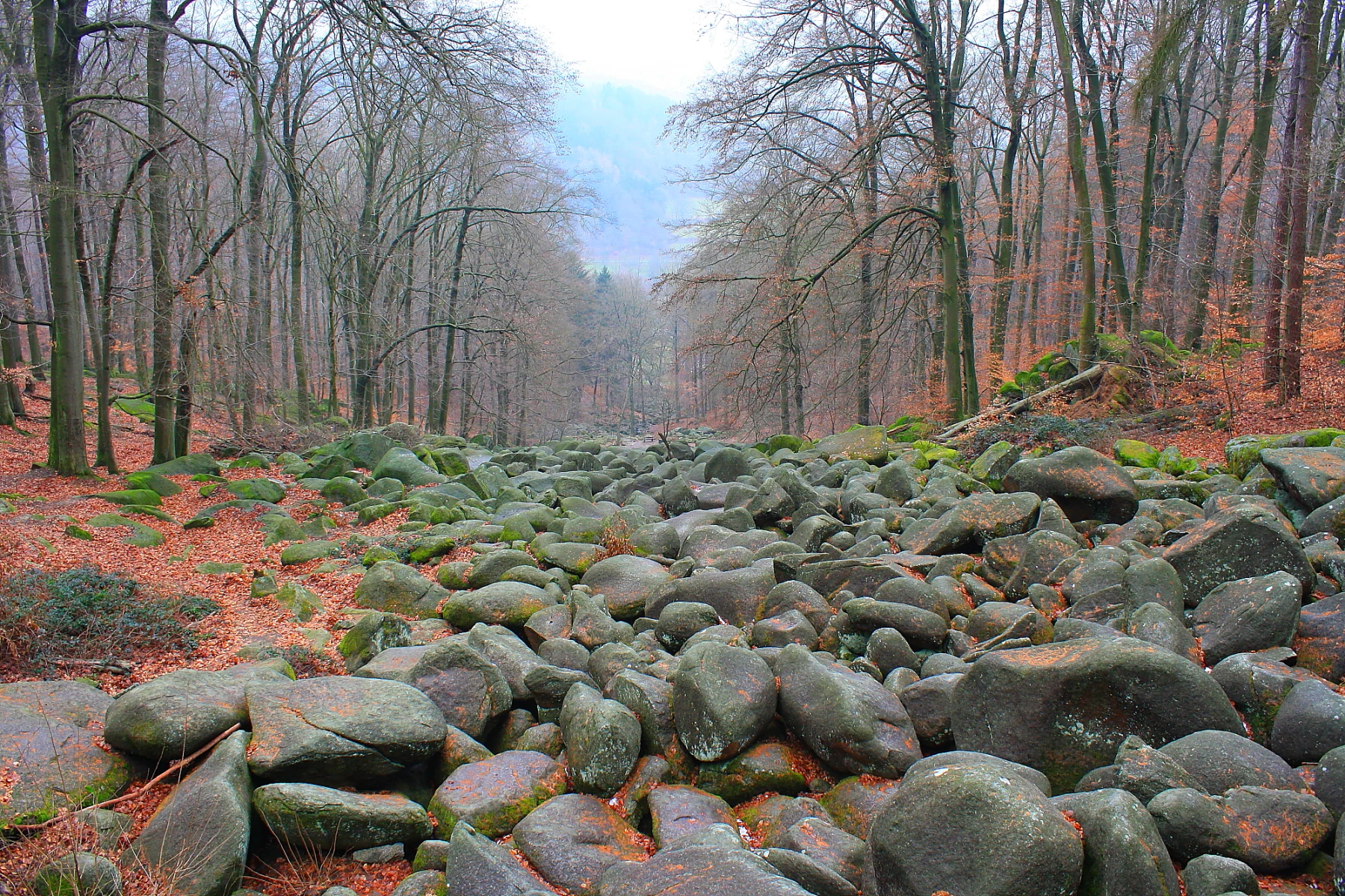
A wide view of a large, boulder-filled slope known as the Felsenmeer, surrounded by a dense forest of tall, leafless trees under a hazy sky.
The Felsenmeer, a massive sea of boulders within the Felsberg bei Reichenbach nature reserve.

Felsberg bei Reichenbach history and protected-area timeline

Felsberg bei Reichenbach was formally placed under nature protection in 1972, when it was designated as a German Naturschutzgebiet under the official identifier 1431001. This designation recognized the area's distinctive combination of geological features and forest habitat as worthy of national-level protection. The legal status set the framework for limiting damaging activities and preserving the integrity of both the rock landscape and the surrounding woodland.

In addition to its national protection, the site later received European recognition through its inclusion in the Natura 2000 network as a Fauna-Flora-Habitat area under the reference code DE-6218-301. This European designation, made under the European Union Habitats Directive, underlined the biodiversity significance of the area beyond German borders and brought the reserve into a transboundary conservation framework.

The site's history of formal protection builds on a much older tradition of local identity tied to the Felsberg and the Felsenmeer. Long before the reserve was established, the landscape was already well known regionally as a geological landmark and a place of folk legends. The 1972 designation and subsequent Natura 2000 listing formalized and expanded this recognition, providing statutory protection for both the granite boulder field and the forest ecosystems that surround it. Today, the area continues to be managed as part of Hesse's network of protected landscapes in the Bergstraße district, with documentation available through the Natureg Hessen information system.

Felsberg bei Reichenbach landscape and geographic character

The landscape of Felsberg bei Reichenbach is defined by the contrast between a forested mountain slope and a dramatic field of massive granite boulders. The reserve sits on the southeastern flank of the Felsberg, a peak that rises to 514 meters above sea level in the western Odenwald. From the valley settlements of Reichenbach and Beedenkirchen, the terrain rises steadily through mixed woodland toward the high point of the mountain, with the boulder-strewn slopes forming the central geological spectacle.

The most striking landscape element is the Felsenmeer Lautertal, a wide field of granite boulders that tumbles down the mountainside. Over countless years, frost action and chemical weathering fractured the once-solid granite outcrop into individual blocks, which then shifted downslope through gravity, creating a dense, chaotic carpet of rounded and angular rocks of widely varying size. The result is a landscape that resembles a frozen sea, hence the German name 'Felsenmeer', meaning 'rock sea'. The boulders are interspersed with mossy patches, small soil pockets, and pockets of trees and shrubs that have managed to establish themselves between the rocks.

Surrounding the boulder field, the reserve's forest contributes to the visual character of the area. Mixed deciduous woodland typical of the Odenwald, including beech and oak stands, drapes across the gentler portions of the slopes and the upper mountain, framing the open rock landscape and providing a continuous green cover. The transition from dense forest through scattered rock outcrops to the broad boulder sea gives the reserve a strong vertical and textural variety, even within its relatively compact extent of about 168 hectares.

Hydrologically, the slopes of the Felsberg feed down into the Lautertal, a wooded valley that forms the broader setting of the reserve. The valley floor, with its villages and farmland, lies outside the protected boundary, creating a clear distinction between the protected upland and the inhabited lowland. Nearby transport corridors, including the L 3098 state road to the east and the B 47 federal road to the south, frame the reserve geographically without intruding into the protected core.

Felsberg bei Reichenbach ecosystems, habitats, and plant life

Felsberg bei Reichenbach protects a notable mosaic of forest and rock habitats that together constitute a distinctive ecological landscape in the western Odenwald. The reserve's vegetation is dominated by mixed deciduous forest typical of the region's beech and oak communities, which covers the majority of the protected area and forms the broader ecological matrix of the site.

The open rock habitats of the Felsenmeer provide a vital ecological counterpoint to the closed forest. Bare granite outcrops, rock crevices, and thin soil pockets between boulders support specialized communities of lichens, mosses, and drought-adapted plants that would not survive under dense tree cover. These open rock communities host insects and other invertebrates adapted to warm, exposed microclimates, and they are considered an important element of the area's biodiversity value.

At the forest edges, particularly where woodland meets the boulder field, transitional zones form ecological gradients that benefit a wide range of species. The combination of shaded interior forest, sun-exposed rock surfaces, and edge habitats creates structural diversity within a relatively small area. The result is a rich pattern of microhabitats that supports more varied wildlife than a uniform forest cover would.

The reserve's integration into the Natura 2000 network indicates that these habitats are considered important at a European level. Particular attention is given to the condition of forest habitat types and to the maintenance of naturally occurring woodland structures, deadwood resources, and undisturbed rock environments. Together, these habitats form an ecologically coherent unit that complements other protected forest sites in the Bergstraße district, contributing to the broader conservation network of the Odenwald.

Felsberg bei Reichenbach wildlife and species highlights

The wildlife of Felsberg bei Reichenbach is closely tied to the alternating forest and rock habitats that define the protected area. The mixed deciduous forest covering most of the slopes provides habitat for a typical range of Odenwald woodland species, including small forest mammals, woodland birds, and a wide community of forest-floor invertebrates. Deadwood, mature trees, and structural diversity within the forest support saproxylic insects and cavity-nesting species that depend on older woodland conditions.

The exposed rock surfaces and boulder crevices of the Felsenmeer host a very different set of animals adapted to warm, dry, and open conditions. Reptiles such as lizards use the sun-warmed stones for basking, while rock-dwelling invertebrates occupy crevices and shaded gaps between boulders. Birds of open and semi-open terrain may use the rocky margins as hunting grounds, while woodland birds dominate the treed portions of the reserve.

The mixture of forest interior, forest edges, and open rock gives the reserve a capacity to support a richer seasonal range of species than a single-habitat site would. Migratory and resident bird communities benefit from the structural variety, while mammals move through the area along continuous forest cover that links the reserve to the larger Odenwald woodland network. Although detailed species inventories are not the focus of this profile, the site's Natura 2000 designation reflects recognition that these habitat combinations are important for the conservation of characteristic Odenwald biodiversity.

Felsberg bei Reichenbach conservation status and protection priorities

Felsberg bei Reichenbach carries a particularly strong conservation profile because of its dual legal status as both a German Naturschutzgebiet and a European Natura 2000 site. The national designation, granted in 1972, established the area as a protected landscape under Hesse's nature conservation framework, with the identifier 1431001 and registration in the World Database on Protected Areas under ID 81649. The Natura 2000 designation, under the Habitats Directive reference DE-6218-301, brought the site into the European conservation network.

The reserve's conservation value lies primarily in its combination of intact forest habitats and unusual open rock habitats. The forest portion contributes to the broader conservation of Odenwald woodland communities, particularly beech-dominated forest types that are of high European interest. The Felsenmeer, meanwhile, preserves a rare open-rock environment that supports specialized flora and fauna not found in closed forest.

The presence of a large, relatively undisturbed boulder field within a forested setting is also significant from a geoconservation perspective. Such sites are increasingly rare in densely populated parts of central Europe and are considered valuable as natural monuments in addition to their ecological role. The reserve therefore serves both biodiversity conservation and the protection of an outstanding geological heritage feature.

By linking the Felsberg to the surrounding Natura 2000 network, the protected area strengthens the overall ecological coherence of the Bergstraße district's conservation system. Although small in absolute terms, the reserve functions as a critical natural anchor in a region where human settlement, agriculture, and infrastructure place continuous pressure on remaining natural landscapes.

Felsberg bei Reichenbach cultural meaning and human context

The Felsberg and its Felsenmeer have a long history of cultural significance within the Lautertal and the broader Bergstraße region. The dramatic boulder landscape has been the subject of local legends and traditional storytelling for generations, contributing to a sense of regional identity that predates modern conservation designations. The granite outcrops and the boulders of the Felsenmeer were formed deep within the Earth's crust and brought to the surface through geological uplift and millions of years of erosion; this long history lends the landscape a cultural resonance as a 'natural monument' that has long been part of the local imagination.

The reserve's setting, nestled between the villages of Reichenbach and Beedenkirchen and bordered by rural valleys and wooded hills, places it firmly within a traditional Odenwald cultural landscape. The interplay of small settlements, agricultural use of the valley floor, and protected upland forest is characteristic of the Bergstraße region, which has long balanced human presence with strong natural and cultural heritage.

The site is also part of the wider context of the Odenwald's geological heritage, sitting close to other prominent peaks and protected areas such as the Melibocus and the Kniebrecht-Orbishöhe range. Together, these landscapes form a chain of iconic Odenwald features that have shaped regional identity, outdoor recreation, and conservation awareness for centuries. The protected status of Felsberg bei Reichenbach reflects a cultural and political commitment to preserving this iconic landscape for both ecological and cultural reasons.

Top sights and standout views in Felsberg bei Reichenbach

The most compelling highlights of Felsberg bei Reichenbach center on the dramatic Felsenmeer, an extensive natural granite boulder field that defines the southeastern flank of the Felsberg. This remarkable rock landscape, combined with the surrounding Odenwald forest, creates a striking visual and ecological contrast within a compact protected area of about 168 hectares. The reserve's dual status as both a national nature reserve and a Natura 2000 Habitats Directive site reflects the rare combination of geological monument value and forest biodiversity importance.

Equally noteworthy is the reserve's role within the Bergstraße district's broader conservation network, linking the Felsberg to nearby protected forest and rock sites in the western Odenwald. Sited near the boundary of Hesse and the broader Rhine-Main region, the area functions as a natural refuge close to major population centers, offering an unusually well-preserved Odenwald mountain experience within easy reach of urban landscapes.

Best time to visit Felsberg bei Reichenbach

The Felsberg bei Reichenbach and its forest slopes can be visited year round, with each season offering a different way of experiencing the landscape. Spring brings fresh green growth to the surrounding beech and oak forests, along with active woodland birdlife, while the boulder field itself remains a constant, with moss and lichen beginning to show their seasonal moisture-rich colors. The mix of mild temperatures and blooming understorey makes spring a particularly rewarding time for visitors interested in the forest ecology of the reserve.

Summer offers the warmest conditions for exploring the Felsenmeer, when the granite boulders store heat and the contrast between the open rock field and shaded forest is most stark. Long daylight hours and fully leafed-out trees create a complete forest canopy, giving visitors a fully immersive Odenwald forest experience. Wildlife observation is also strong, with reptiles and warm-adapted invertebrates particularly active around the sun-warmed rock surfaces.

Autumn is widely regarded as one of the most atmospheric periods to experience the reserve. The deciduous trees turn color across the forested slopes, framing the gray granite boulders of the Felsenmeer with russet, gold, and amber. Cooler temperatures and softer light give the landscape a quieter, more contemplative character, and fruiting forest flora adds additional interest for naturalists. Winter, when the trees are bare and occasional snow may dust the rocks, offers the starkest contrast between forest architecture and the open boulder field, revealing the full geological drama of the Felsberg under the most minimal forest cover. Hikers should plan around potentially icy conditions on the boulder field in winter months.

Monthly climate preview

Long-term monthly temperature ranges and precipitation patterns measured at representative coordinates

Felsberg bei Reichenbach Climate Normals, Annual Temperature and Precipitation Rhythm

Representative coordinate records show average temperatures ranging from near freezing to warm mid-summer maximums alongside consistent year-round precipitation rates. Examining the full twelve-month profile provides complete historical averages for evaluating long-term environmental patterns.
Annual mean10 °C
0 °C20 °C
Jan
Feb
Mar
Apr
May14°
Jun18°
Jul20°
Aug20°
Sep15°
Oct10°
Nov
Dec
Warmest month
July

20.3 °C

Coolest month
January

0.1 °C

Wettest month
July

2.4 mm/day

Driest month
April

1.5 mm/day

Park location guide

Geography guide, regional context, and park location map for Felsberg bei Reichenbach

Felsberg bei Reichenbach park geography, regions, and map view in Germany

Understand where Felsberg bei Reichenbach sits in Germany through a broader geographic reading of the surrounding landscape, nearby location context, and its mapped position within the national park landscape.

How Felsberg bei Reichenbach fits into Germany

Germany is a federal republic in Western and Central Europe with a population of over 83 million across sixteen constituent states. It is Europe's largest economy by nominal GDP and a major global exporter and importer. The capital is Berlin, and the country borders Denmark, Poland, Czech Republic, Austria, Switzerland, France, Luxembourg, Belgium, and the Netherlands.

Wider geography shaping Felsberg bei Reichenbach in Germany

Germany is located in Western and Central Europe, spanning 357,022 km². It borders Denmark to the north, Poland and the Czech Republic to the east, Austria and Switzerland to the south, and France, Luxembourg, Belgium, and the Netherlands to the west. The country has coastlines on the Baltic Sea and North Sea to the north, with the Alps located in the southern region.

Map view of Felsberg bei Reichenbach

Use this park location map to pinpoint Felsberg bei Reichenbach in Germany, understand its exact geographic position, and read its mapped placement within the surrounding landscape more clearly.

Pigeon | © OpenStreetMap contributors

Location context for Felsberg bei Reichenbach

Hessen
Recorded earthquake history

Explore Felsberg bei Reichenbach Earthquake Records and Seismic Data

Browse the MoriAtlas catalogue of recorded earthquake events near Felsberg bei Reichenbach. Access detailed seismic logs to review historical activity and geographic data associated with the reserve for your regional research.

Felsberg bei Reichenbach Earthquake History

Catalogued events

22 events

Strongest magnitude

Magnitude 3.8

Most recent event

May 17, 2014

This history includes earthquakes recorded inside the park or within 50 km of its borders

Visual exploration of granite boulder fields and Odenwald forest habitats

Felsberg bei Reichenbach Photos and Landscape Scenery

Visual records capture the rugged terrain of Felsberg bei Reichenbach, revealing massive granite boulder formations and dense deciduous woodland across the mountain slopes. Examining protected area imagery provides clearer insight into geological weathering processes and Odenwald conservation environments.

A wide view of a large, boulder-filled slope known as the Felsenmeer, surrounded by a dense forest of tall, leafless trees under a hazy sky.

Park atlas

Compare adjacent Odenwald forest reserves and geological protected areas

Parks Near Felsberg bei Reichenbach and Surrounding Protected Landscapes

Browsing other parks near Felsberg bei Reichenbach reveals related forest habitats and granite landscapes across the Odenwald hills. Extending the geographic comparison helps trace regional conservation networks and neighboring protected terrain throughout southern Hesse.
A horizontal watercolor illustration of a soft, hazy landscape featuring light pink blooming trees in a green field, with rolling, misty purple and brown hills in the background.
Nature reserveHesse
About 2.4 km away#1 closest

North

Fuchswiese bei Stettbach: Mapped Nature Reserve and Protected Meadow Landscape in Hesse

Exploring the ecological boundaries of a specialized wet meadow reserve in southern Hesse

Fuchswiese bei Stettbach is a dedicated nature reserve serving as a critical habitat for threatened meadow butterfly species. Located in the Darmstadt-Dieburg district of Hesse, this protected area preserves wet meadow vegetation amidst the northern Odenwald fringe. The site offers a focused view into how small, carefully managed landscapes contribute to the broader ecological health and regional geography of central Germany.

Area
0.03 km²
Established
2010
A watercolor painting of a pastoral landscape with soft green meadows, scattered trees, and distant purplish hills under a white sky.
Nature reserveHessen
2.7 km away#2 closest

Southwest

Magerrasen von Gronau mit angrenzenden Flächen Protected Landscape and Regional Geography

A network of calcareous meadows in the Odenwald foothills

Located in the Bergstraße district of Hessen, this protected area spans three distinct sub-areas characterized by nutrient-poor calcareous soils. These warm, sun-exposed meadows serve as an essential refugium for orchid diversity and specialized butterfly populations, standing as a representative example of successfully managed dry grassland ecosystems within the broader Geo-Naturpark Bergstraße-Odenwald.

Area
1.6 km²
Established
2004
A soft watercolor painting of a rolling green hillside with trees, set against a pale, light-colored background.
Nature reserveHessen
About 3.8 km away#3 closest

West

Orbishöhe von Auerbach und Zwingenberg: Geography, Landscape, and Protected Area Mapping

An examination of Hessian quarry-based ecological conservation sites.

The Orbishöhe von Auerbach und Zwingenberg nature reserve serves as a prime example of localized conservation within the Odenwald hills. Its landscape is defined by former quarry faces and open slope terraces, which provide a critical habitat for rare and threatened plant species. This resource offers a clear look at the reserve's topography, physical boundaries, and its broader role within the Natura 2000 network of protected German lands.

Area
0.064 km²
Established
1988
A horizontal watercolor illustration of a soft green landscape with meadows, scattered trees, and distant rolling hills under a pale pink sky.
Nature reserveHessen
About 4.4 km away#4 closest

Southeast

Schannenbacher Moor Nature Reserve: Geographic Overview and Protected Area Boundaries

Wetland and forest mosaic in the southern Hessian Odenwald

Schannenbacher Moor represents a significant protected area within Hessen, characterized by its combination of raised bog remnants, reedbeds, and near-natural floodplain woodlands. Framed by the Krehberg slopes and the Meerbach stream system, the reserve offers a rare example of low mountain bog ecology and biodiversity conservation. This mapped landscape provides essential data on the distribution of mire plant communities and bryophyte habitats in the region.

Area
0.162 km²
Established
1975
IUCN
IV
A watercolor painting showing a soft, stylized landscape of green meadows, sparse trees, and distant rolling hills against a white background.
Nature reserveHesse
6.4 km away#5 closest

West

Im Dulbaum bei Alsbach Nature Reserve: Mapped Inland Dunes and Grassland Geography

A vital protected sandy terrain in the Hessian Rhine Plain

Im Dulbaum bei Alsbach protects a remnant of the historic Rhine graben sand dune belt in southern Hesse. This nature reserve provides essential habitat connectivity for heat-loving species through its distinct calcareous sand grasslands and former quarry terrain, offering a look into the region's complex ecological history.

Area
0.092 km²
Established
1994
IUCN
IV
Relief
Lowland
A horizontal watercolor painting showing a soft, impressionistic landscape with rolling hills, sparse trees, and pale green and pink tones on a white background.
Nature reserveHesse
About 6.7 km away#6 closest

Northwest

Kalksandkiefernwald bei Bickenbach, Pfungstadt und Seeheim-Jugenheim Protected Area Atlas

A rare calcareous sand pine forest in the Hessian Rhine plain

Located in the Darmstadt-Dieburg district, this reserve protects an airy, light-filled woodland on calcareous sandy ground. The terrain is defined by its gentle undulations and historical woodland grazing traces, offering a unique look at forest management in the Rhine plain. Explore the distribution of its two distinct sections, including the specialized sand grass vegetation found along its managed utility corridors.

Area
0.874 km²
Established
1996
IUCN
IV
Relief
Lowland
A soft, delicate watercolor painting depicting a meandering river flowing through a lush, grassy wetland landscape with rolling hills in the background.
Nature reserveHessen
About 7.5 km away#7 closest

West

Altneckarlachen von Alsbach, Hähnlein und Bickenbach: Protected Wetland and River Geography

A rare mosaic of prehistoric river loops in the Hessian Rhine plain

Altneckarlachen von Alsbach, Hähnlein und Bickenbach protects a unique sequence of prehistoric Neckar meanders featuring shallow water zones, reed belts, and black-alder swamp forest. This nature reserve in the Darmstadt-Dieburg district remains a critical wetland sanctuary, preserving a vital ecological cross-section of the ancient Rhine-Neckar landscape and its associated peatland soils.

Area
0.892 km²
Established
1990
IUCN
IV
Relief
Lowland
A watercolor landscape illustration showing a winding stream, marsh grasses, and trees with soft rolling hills in the background, set against a pale background.
Nature reserveHessen
About 7.6 km away#8 closest

Northwest

Pfungstädter Moor Nature Reserve: Hessian Wetland and Ancient River Landscape

Protected wetland area in the Hessian Rhine plain

This nature reserve encompasses a rare silted-up segment of the ancient Neckar river, forming a complex of reed beds, alder carr, and peat bog habitats. Managed through creative restoration techniques that lift Rhine water into the moor, the landscape remains a vital ecological sanctuary in the heart of Hesse, standing in sharp contrast to the surrounding agricultural terrain.

Area
0.97 km²
Established
1955
IUCN
IV
Relief
Lowland

Common questions about visiting, size, designation, and location context for Felsberg bei Reichenbach

Felsberg bei Reichenbach FAQs for park facts, access, geography, and protected area context

Find quick answers about Felsberg bei Reichenbach, including protected-area facts, park geography, trail and visitor context, and how the park fits into its surrounding country and regional landscape.
MoriAtlas Explorer

Continue Your Protected Areas Search Across the Global Atlas

Deepen your exploration by continuing the structured search for national parks and protected areas worldwide. Utilize the comprehensive filtering capabilities to compare different conservation landscapes and refine your understanding of global park geography. Discover more about the distribution and characteristics of protected natural areas.

Global natural geography