Mori Atlas logo
Nature reserveFeuchtwiesen Atterwasch

A detailed geographic study of stream-fed meadows and alluvial ecosystems in Brandenburg

Feuchtwiesen Atterwasch Nature Reserve: Mapping the Protected Wetlands and Floodplain Geography

(Naturschutzgebiet Feuchtwiesen Atterwasch)

Feuchtwiesen Atterwasch is a significant nature reserve situated in the Spree-Neiße district of Brandenburg, Germany. This protected area centers on a complex hydrological network defined by the Schwarze Fließ stream and a surrounding mosaic of wet meadows, calcareous fens, and black alder woodlands. Through a combination of stream corridors and marshy terrain, the reserve provides a critical habitat for diverse species, including the European otter and Eurasian beaver, while serving as a protected node within the Gubener Land natural region.

wet meadowslowland floodplainNatura 2000 siteFFH habitatnature reservealluvial forest

Feuchtwiesen Atterwasch

Nature reserve

Park overview

Structured park overview, official facts, and landscape profile for Feuchtwiesen Atterwasch

Feuchtwiesen Atterwasch park facts, protected area profile, and essential visitor context

Review the core facts for Feuchtwiesen Atterwasch, including designation, size, terrain, visitor scale, habitats, and operating context in one park-focused overview.

About Feuchtwiesen Atterwasch

Feuchtwiesen Atterwasch protects a lowland floodplain landscape in the eastern German state of Brandenburg, just a short distance from the Polish border in the wider Neiße river region. The reserve is anchored on the Schwarze Fließ, a small lowland stream that rises northwest of Bärenklau in the municipality of Schenkendöbern and runs roughly fifteen kilometers through a mosaic of wet meadows, ditches, alder woodlands, and small standing waters before flowing into the Lusatian Neiße. The protected area lies within the Gubener Land natural region, a transitional landscape shaped by glacial history, low precipitation, and a continental-influenced climate that produces fog-prone, frost-sensitive lowlands.

Ecologically, the reserve stands out for the density and diversity of Habitats Directive habitat types packed into a relatively small footprint. Surveys have documented natural eutrophic lakes with Magnopotamion or Hydrocharition vegetation, lowland streams of the Ranunculion fluitantis type, matgrass swards, tall herb fringe communities of the moist lowland kind, extensive lowland hay meadows of the Arrhenatherion and Brachypodio-Centaureion nemoralis type, calcareous fens, alluvial forests of black alder and ash, and moist mixed oak and hornbeam woodland. This level of habitat variety, combined with traditional grassland management, gives the area an unusually high niche density for invertebrates, amphibians, and wetland birds.

From a conservation perspective, Feuchtwiesen Atterwasch exemplifies how small-scale Brandenburg protected areas can play an outsized role in European biodiversity policy. It serves both as a national nature reserve under the Brandenburg Naturschutzgesetz and as a Special Area of Conservation under the EU Habitats Directive, carrying the Natura 2000 site code DE4053302. Its designation history reflects the broader European effort to safeguard floodplain meadow systems that have been heavily reduced elsewhere on the continent.

Within the local landscape context, the reserve sits entirely inside the larger Gubener Fließtäler landscape protection area, meaning the Naturschutz status adds a stricter layer of protection on top of broader regional landscape management. Visitors and researchers encounter a working wet agricultural and forestry landscape where traditional mowing, water-level management, and grazing continue to shape ecological outcomes, rather than a strictly wilderness setting.

Quick facts and research context for Feuchtwiesen Atterwasch

Feuchtwiesen Atterwasch is a nature reserve of approximately 193 hectares located in the Spree-Neiße district of Brandenburg, east of the village of Bärenklau in the municipality of Schenkendöbern. It lies south of the B 320 federal road and west of the B 112, and is fully encompassed by the larger landscape protection area Gubener Fließtäler. The area is administered under the German Naturschutz (Nature Conservation) framework established on 27 August 2004, with a revised ordinance issued in 2015, and it is also designated as a Natura 2000 Special Area of Conservation under EU Habitats Directive code DE4053302.

The reserve occupies part of the Gubener Land natural region and is shaped by the Schwarze Fließ stream with its tributaries and drainage ditches. It is classified by IUCN as Category IV, meaning a habitat and species management area. Mean annual temperature is about 8.5 °C and annual precipitation averages around 608 mm, with frequent fog and late frosts in the low-lying sections. Habitat composition includes inland waters, mires and marshy fringes, dry grassland, wet and mesophile grassland, arable land, broadleaf forest, and mixed woodland.

Protection and recognition

Documented terrestrial protection scope, international recognition sources, and official designation details

Feuchtwiesen Atterwasch Protection Status and Natura 2000 Recognition

Feuchtwiesen Atterwasch maintains a documented terrestrial protection scope backed by official Natura 2000 recognition records. Structured data registries compile international designation sources, management parameters, and verified protected area metrics.

International recognition

Protection details

Protection scope
Terrestrial
Transboundary protection
No
WDPA ID
329372
Park context

Deeper park guide and search-rich context for Feuchtwiesen Atterwasch

Feuchtwiesen Atterwasch history, landscape, wildlife, and travel context

Explore Feuchtwiesen Atterwasch through its history, landscape character, ecosystems, wildlife, conservation priorities, cultural context, and seasonal travel timing in a structured park guide built for atlas discovery and search intent.

Why Feuchtwiesen Atterwasch stands out

Feuchtwiesen Atterwasch is best known for its wet meadow and stream system centered on the Schwarze Fließ, which supports a richly patterned floodplain landscape of meadows, ditches, and alluvial forests. The reserve is particularly distinguished for harboring a high diversity of European-protected habitat types within a relatively compact area, including calcareous fens, lowland hay meadows, running waters with floating vegetation, and black alder and ash alluvial forests. It is also recognized for the unusual concentration of protected species attached to wet floodplain environments, from large mammals such as the European otter and Eurasian beaver to specialized invertebrates and birds of damp meadows and reeds. The combination of small-scale water features and extensively managed grassland makes it a reference site for floodplain meadow conservation in the Lusatian lowlands.
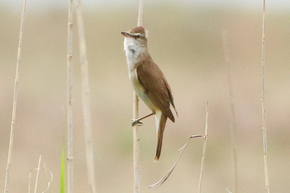
A Great Reed Warbler with brown plumage perched vertically on a single slender reed stalk against a soft, blurred background.
A Great Reed Warbler perched on a reed stem in its natural wetland habitat.

Feuchtwiesen Atterwasch history and protected-area timeline

The process leading to Feuchtwiesen Atterwasch becoming a protected area began in September 2000, when a proposal was submitted to designate the site as a Site of Community Importance under the European Habitats Directive. This proposal reflected growing awareness of the conservation value of the wet meadows, ditches, and alluvial forests around the Schwarze Fließ.

The area received formal protection at the national level on 9 October 2004, when it was designated as a Naturschutzgebiet by ordinance dated 27 August 2004. Shortly afterward, in December 2004, the European Commission recognized it as a Natura 2000 site, with the official code DE4053302. The underlying ordinance was later amended through Article 17 of a regulation issued on 19 August 2015, reflecting updates to the management framework and the addition of further habitat types to the management plan.

Administration of the reserve falls to the Landesamt für Umwelt (LfU) of Brandenburg, specifically its RW9 division. Management planning activities have progressively refined the habitat classification, including the addition of moist oak and hornbeam mixed woodland (habitat type 9160) and documentation of additional threatened species in the management plan over time.

Feuchtwiesen Atterwasch landscape and geographic character

Feuchtwiesen Atterwasch occupies a low-lying floodplain within the Gubener Land natural region, a part of the Lusatian glacially shaped landscape in southeastern Brandenburg. The terrain is flat to gently undulating, dominated by meadows, ditches, small streams, and patches of woodland, rather than dramatic relief. Elevations are modest, and the landscape quality comes primarily from the intricate network of water features and the alternation of open grassland with darker rows of trees along the watercourses.

The Schwarze Fließ stream is the defining hydrological element. It rises northwest of Bärenklau, threads through the reserve with numerous small tributaries and drainage ditches, and travels approximately fifteen kilometers before reaching the Lusatian Neiße. The stream and its ditches create corridors of wet woodland and tall herb vegetation in a broader matrix of meadows and arable land. Small standing waters interspersed across the reserve add further diversity, ranging from marshy hollows to more clearly defined ponds and lake basins.

In terms of land cover, the reserve reflects a classic mixed lowland floodplain. Inland waters, mires, and marshy fringes together account for a substantial share of the area, supplemented by substantial wet and mesophile grassland with smaller contributions from dry grassland, heath-type vegetation, arable land, broadleaf woodland, and mixed woodland. This mosaic of habitats, rather than any single feature, gives the landscape its distinctive modest but ecologically rich character.

Feuchtwiesen Atterwasch ecosystems, habitats, and plant life

Ecologically, Feuchtwiesen Atterwasch is defined by the interaction of water and meadow at the scale of the floodplain. The combination of slow-moving streams, drainage ditches, seepage areas, and small standing waters produces a moisture regime that supports diverse wetland communities. The reserve's protected habitat types include naturally eutrophic standing waters with Magnopotamion or Hydrocharition vegetation, lowland streams rich in floating Ranunculion fluitantis vegetation, species-rich matgrass swards in drier pockets, moist tall herb communities along ditches and stream margins, and calcareous fens that hold specialist mire plants.

The grassland habitats form a second pillar of the reserve's natural character. Extensive lowland hay meadows of the Arrhenatherion and Brachypodio-Centaureion nemoralis type are managed in ways that sustain wildflowers and pollinator habitat, while still functioning as working agricultural land. Surrounding these meadows are patches of dry grassland and steppe-like areas at higher, drier points, and broadleaf and mixed woodlands that act as buffers and ecological corridors. Alluvial forests of black alder and ash line the wetter stream corridors, and moist oak-and-hornbeam woodland occupies transitional areas.

This concentration of habitats is unusual for an area of its size in Brandenburg and explains why the site is integrated into the European Natura 2000 network. Plant surveys have identified numerous specialist wetland species across the reserve, including rare sedges, several orchid and broomrape relatives in the meadows, aquatic species in the lentic waters, and characteristic mire and woodland flora. The reserve thus functions as a working lowland landscape in which traditional land use and habitat diversity reinforce each other.

Feuchtwiesen Atterwasch wildlife and species highlights

Feuchtwiesen Atterwasch supports a wide range of fauna associated with wetland, meadow, and woodland habitats. Among the most prominent mammals, the European beaver (Castor fiber) inhabits the watercourses, and the European otter (Lutra lutra) is documented as breeding at the Torfstich Atterwasch peat-cutting area. Bats are also present, with barbastelle (Barbastella barbastellus), common pipistrelle (Pipistrellus pipistrellus), and brown long-eared bat (Plecotus auritus) recorded in the management plan.

The reserve's amphibian and reptile fauna mirrors the wet-meadow character of the site. Green toad (Bufotes viridis), moor frog (Rana arvalis), pool frog (Pelophylax lessonae), common frog (Rana temporaria), and agile lizard (Lacerta agilis) have been documented as valued or threatened species in the reserve's management plan. Fish life is represented in running water by the European brook lamprey (Lampetra planeri).

Invertebrates are a particular strength. The reserve supports Annex II species under the Habitats Directive including the large copper butterfly (Lycaena dispar), the hermit beetle (Osmoderma eremita), the narrow-mouthed whorl snail (Vertigo angustior), and the Desmoulins' whorl snail (Vertigo moulinsiana). Recent surveys added the yellow-spotted whiteface dragonfly (Leucorrhinia pectoralis) to the management plan, and notable moth records include the Jersey tiger (Callimorpha dominula) and Poplar underwing (Catocala elocata).

The bird community features both Annex I species of the EU Birds Directive and other characteristic wetland and meadow species. Kingfisher (Alcedo atthis), white stork (Ciconia ciconia), common crane (Grus grus), and red-backed shrike (Lanius collurio) are designated for protection. Additional recorded species include great reed warbler (Acrocephalus arundinaceus), mallard (Anas platyrhynchos), common nightingale (Luscinia megarhynchos), European turtle dove (Streptopelia turtur), northern lapwing (Vanellus vanellus), red kite (Milvus milvus), and common goldeneye (Bucephala clangula).

Feuchtwiesen Atterwasch conservation status and protection priorities

The conservation significance of Feuchtwiesen Atterwasch is embedded in its double status as a national nature reserve and a European Natura 2000 Special Area of Conservation under the Habitats Directive. The site is classified in the IUCN system as Category IV: a Habitat or Species Management Area, meaning the land is actively managed to maintain particular habitats and the species that depend on them.

At the European level, the reserve protects a notable suite of Annex I habitat types, including natural eutrophic lakes, lowland streams with floating vegetation, species-rich matgrass swards, moist tall herb fringes, lowland hay meadows, calcareous fens, black alder and ash alluvial forests, and moist mixed oak and hornbeam woodland. In addition, several Annex II species have been documented within the property, including European beaver, European otter, large copper butterfly, hermit beetle, narrow-mouthed whorl snail, and Desmoulins' whorl snail. Recent management planning has also extended coverage to the barbastelle bat and the yellow-spotted whiteface dragonfly.

At the national and regional level, the area is protected by the Brandenburg nature conservation ordinance of 27 August 2004, amended in 2015, and is fully included within the Gubener Fließtäler landscape protection area. This layering of national, landscape, and European designations reflects the importance of preserving floodplain meadow systems and their associated hydrology in the Lusatian-Guben region. The reserve illustrates how relatively small but well-managed lowland protected areas can contribute meaningfully to European biodiversity targets, especially for habitats that depend on continued low-intensity agricultural and water management.

Feuchtwiesen Atterwasch cultural meaning and human context

Feuchtwiesen Atterwasch can be understood as part of a long-running cultural landscape of wet meadow use in the Lusatian lowlands. The combination of mown meadows, ditches, and streams reflects centuries of pastoral and agricultural management in which communities shaped drainage and swards to maintain productive fodder land. The name Atterwasch itself is a local place name rooted in this small settlement tradition.

The reserve lies within the municipality of Schenkendöbern and the Spree-Neiße district, an area marked by close proximity to the Polish border, with Guben located on the opposite side of the Neiße river. The wider region has historically been shaped by mixed German and Sorbian cultural influences in Lower Lusatia, with traditional land use patterns that favored small-scale grazing, hay cutting, and pond management. The contemporary reserve therefore reflects not only ecological but also continuing agricultural heritage, maintaining the management practices that produced the habitat mosaic in the first place.

Top sights and standout views in Feuchtwiesen Atterwasch

Feuchtwiesen Atterwasch highlights include a tight concentration of European-protected habitat types within a compact 193-hectare reserve, from eutrophic lakes and flowing streams to calcareous fens and alluvial forests. The Schwarze Fließ anchors the landscape and creates the hydrological conditions that sustain the wet meadow mosaic. The reserve's species list is unusually rich for its size, encompassing beaver and otter, multiple Annex I and Annex II species under the Habitats Directive, breeding birds of wet meadows and reeds, and a diverse assemblage of dragonflies, butterflies, and snails. As a double-designated national and European site within the Gubener Fließtäler landscape protection area, it represents a small but high-value node in Brandenburg's contribution to European biodiversity conservation.

Best time to visit Feuchtwiesen Atterwasch

Spring through early summer tends to be the most rewarding period for experiencing Feuchtwiesen Atterwasch, when wet meadows support flowering hay plants, water plants bloom in ditches and ponds, and breeding birds such as common crane, lapwing, and reed warblers are active. Early mornings in late spring often bring the best chances of seeing mammals near watercourses. Autumn visits can also be productive for observing amphibian movements in damp weather and for appreciating the muted, atmospheric character of lowland floodplain mists; the area's climatologically prone fog and late frosts are part of the regional charm. Winter typically offers quieter, more contemplative conditions, though frost and snow can limit access to less-prepared paths.


Monthly climate preview

Examine long term temperature ranges and monthly precipitation averages across the protected terrain.

Feuchtwiesen Atterwasch Climate Normals and Annual Temperature Patterns

Historical data records monthly average temperatures spanning from sub zero winter minimums to warm summer maximums alongside consistent precipitation distribution throughout the year. Detailed monthly breakdowns provide deeper insight into long term climate rhythms measured at representative coordinate points across the protected landscape.
Annual mean9 °C
-1 °C21 °C
Jan-1°
Feb
Mar
Apr
May14°
Jun18°
Jul21°
Aug20°
Sep15°
Oct
Nov
Dec
Warmest month
July

20.5 °C

Coolest month
January

-1 °C

Wettest month
July

2.6 mm/day

Driest month
April

1.1 mm/day

Park location guide

Geography guide, regional context, and park location map for Feuchtwiesen Atterwasch

Feuchtwiesen Atterwasch park geography, regions, and map view in Germany

Understand where Feuchtwiesen Atterwasch sits in Germany through a broader geographic reading of the surrounding landscape, nearby location context, and its mapped position within the national park landscape.

How Feuchtwiesen Atterwasch fits into Germany

Germany is a federal republic in Western and Central Europe with a population of over 83 million across sixteen constituent states. It is Europe's largest economy by nominal GDP and a major global exporter and importer. The capital is Berlin, and the country borders Denmark, Poland, Czech Republic, Austria, Switzerland, France, Luxembourg, Belgium, and the Netherlands.

Wider geography shaping Feuchtwiesen Atterwasch in Germany

Germany is located in Western and Central Europe, spanning 357,022 km². It borders Denmark to the north, Poland and the Czech Republic to the east, Austria and Switzerland to the south, and France, Luxembourg, Belgium, and the Netherlands to the west. The country has coastlines on the Baltic Sea and North Sea to the north, with the Alps located in the southern region.

Map view of Feuchtwiesen Atterwasch

Use this park location map to pinpoint Feuchtwiesen Atterwasch in Germany, understand its exact geographic position, and read its mapped placement within the surrounding landscape more clearly.

Pigeon | © OpenStreetMap contributors

Location context for Feuchtwiesen Atterwasch

BrandenburgLandkreis Spree-Neiße

Visual reference guide to wet meadows, stream corridors, and alluvial habitats.

Feuchtwiesen Atterwasch Photos and Protected Area Landscape Scenery

Visual documentation provides clear insight into the wet meadows, drainage ditches, and alluvial forests that define the protected terrain of Feuchtwiesen Atterwasch. Examining actual habitat imagery helps researchers understand the lowland floodplain character and hydrological networks of the region more thoroughly.

A Great Reed Warbler with brown plumage perched vertically on a single slender reed stalk against a soft, blurred background.

Park atlas

Compare regional wetland reserves and connected conservation areas across Brandenburg

Explore Parks Near Feuchtwiesen Atterwasch and Surrounding Protected Landscapes

Visitors exploring Feuchtwiesen Atterwasch can examine nearby lowland nature reserves and connected river valley habitats. Comparing adjacent protected areas reveals broader regional patterns in floodplain ecology and wetland preservation.
Nature reserveLubusz Voivodeship
About 18 km away#1 closest

East

Dębowiec Nature Reserve: Protected Forest Geography in the Lubusz Voivodeship of Western Poland

A faunistic nature reserve protecting ancient oak stands and saproxylic beetle habitats.

Dębowiec Nature Reserve is a designated faunistic site in Gmina Gubin that preserves an exceptional collection of veteran sessile oaks. Occupying a compact area within the Gubin Forest District, the reserve maintains a distinct acidic forest mosaic that supports rare invertebrate communities and diverse avian populations in the undulating terrain of western Poland.

Area
0.094 km²
Established
1984
Relief
Lowland
Scope
Terrestrial
Nature reserveLubusz Voivodeship
About 21 km away#2 closest

Southeast

Mierkowskie Suche Bory Nature Reserve: Geographic Overview and Protected Landscapes

Forest conservation and dune topography in Lubusz Voivodeship

Mierkowskie Suche Bory encompasses 195 hectares of sandy, nutrient-poor terrain in western Poland. The reserve features an unusual mix of arc-shaped dune ridges, such as the Białogóra viewpoint, and damp boggy depressions. This site represents a significant Natura 2000 protected area, showcasing rare pioneer sand grasslands and lichen-dominated pine stands that are increasingly uncommon in the regional landscape.

Area
1.946 km²
Established
2006
Relief
Lowland
Climate
Temperate
Nature reserveLubusz Voivodeship
About 22 km away#3 closest

East

Młodno Nature Reserve: Mapped Protected Peatland and Wetland Landscapes in Lubusz Voivodeship

Geographic analysis of lowland mire and pine forest mosaic

Examine the territorial footprint of Młodno Nature Reserve in western Poland. This site offers insight into deep-sediment organic basins and the ecological transition zones between marshland and pine-dominated woodlands within the Torzym Plain.

Area
0.929 km²
Established
1988
Relief
Lowland
Scope
Terrestrial
Soft, muted watercolor illustration depicting a marshy, low-lying landscape with gentle hills in the background and grassy vegetation in the foreground.
Nature reserveBrandenburg
23 km away#4 closest

East

Dammer Moor Nature Reserve: Protected Wetland and Mire Landscapes in Brandenburg

Geographic overview of a rare Natura 2000 watershed habitat

Dammer Moor features a distinctive calcareous valley mire characterized by calcium mudde, forming a vital protected mosaic within the Lieberose area of Brandenburg. This reserve supports a diverse range of habitats including base-rich Molinion meadows, old oak woodlands, and alder-ash riparian zones that provide essential refuge for numerous amphibian and reptile species.

Area
1.807 km²
Established
1990
IUCN
IV
Relief
Lowland
Nature reserveBrandenburg
About 29 km away#5 closest

North

Dammühlenfließniederung Nature Reserve: Brandenburg Protected Land and Geography Atlas

Floodplain and riparian habitats in the Niederlausitz region

Explore the geographic framework of Dammühlenfließniederung, an essential nature reserve in eastern Brandenburg. This area safeguards the Dammühlenfließ stream valley and a segment of the Schwielochsee lakeshore, representing the unique glacial lowlands of the region through a focused wetland and floodplain corridor.

Area
0.79 km²
Established
1998
IUCN
IV
A watercolor painting showing a panoramic view of the Spree River mouth with green trees, reeds, and marshy water areas.
Nature reserveBrandenburg
31 km away#6 closest

Northwest

Alte Spreemündung Nature Reserve: Protected Wetland and River Geography in Brandenburg

A preserved mosaic of river mouths and lake shorelines

Alte Spreemündung serves as a focal point for understanding the transition between the River Spree and the Schwielochsee in Brandenburg. This protected area covers a compact, water-shaped terrain characterized by riparian habitats and ancient river arms. It remains a key site for examining the glacial geomorphology and lowland water dynamics prevalent across northeastern Germany.

Area
1.08 km²
Established
1990
IUCN
IV
Nature reserveBrandenburg
33 km away#7 closest

South

Koselmühlenfließ Nature Reserve: A Protected Stream Valley in the Brandenburg Region

Geographic overview of the Lusatian land ridge brook habitat

Koselmühlenfließ protects a largely natural lowland stream and its floodplain corridor set amidst the undulating landscapes of the Lusatian land ridge. This nature reserve in the Spree-Neisse district represents a focused contribution to the Brandenburg conservation network, highlighting the value of small-scale brook environments in northeast Germany.

Area
1.12 km²
Established
2006
IUCN
IV
Relief
Lowland
Nature reserveBrandenburg
About 38 km away#8 closest

Southeast

Zschornoer Wald Nature Reserve: Regional Geography and Protected Landscape Analysis

A Lusatian forest protected area within the Spree-Neisse district.

Zschornoer Wald represents a notable example of post-Cold War land reclamation in Brandenburg, Germany. This 628 hectare nature reserve serves as an ecological anchor near the Lausitzer Neisse river, providing vital forest habitat management. By mapping its unique origins as a former bombing range alongside its current conservation role, this atlas entry provides a comprehensive look at the reserve's physical geography, human-altered terrain, and its position within the broader Spree-Neisse landscape.

Area
6.28 km²
Established
2002
IUCN
IV
Relief
Lowland

Common questions about visiting, size, designation, and location context for Feuchtwiesen Atterwasch

Feuchtwiesen Atterwasch FAQs for park facts, access, geography, and protected area context

Find quick answers about Feuchtwiesen Atterwasch, including protected-area facts, park geography, trail and visitor context, and how the park fits into its surrounding country and regional landscape.
MoriAtlas Explorer

Continue Your Protected Areas Search Across the Global Atlas

Deepen your exploration by continuing the structured search for national parks and protected areas worldwide. Utilize the comprehensive filtering capabilities to compare different conservation landscapes and refine your understanding of global park geography. Discover more about the distribution and characteristics of protected natural areas.

Global natural geography