Mori Atlas logo
Nature reserveFichtelberg

A concentrated showcase of subalpine meadows, rare mire systems, and ancient periglacial landforms in Saxony.

Fichtelberg Nature Reserve: Mapping the Protected Landscapes and High-Altitude Geography of the Erzgebirge

(Naturschutzgebiet Fichtelberg)

Fichtelberg Nature Reserve represents a critical protected area within the Saxon Erzgebirge, encompassing high-altitude slopes and diverse montane habitats near the German-Czech border. This reserve preserves an essential mosaic of Nardus grasslands, spruce forests, and rare mire systems shaped by long-term geological processes. Explorers can examine the reserve's unique ice-age relict features, including the distinct frost-patterned ground known as Beerhübl, which anchor this landscape as a vital reference site for regional nature conservation.

mountain meadowsNardus grasslandsmountain heathssubalpine tall-herb communitiesspruce forestsmires and bogs

Fichtelberg

Nature reserve

Park overview

Structured park overview, official facts, and landscape profile for Fichtelberg Nature Reserve

Fichtelberg Nature Reserve park facts, protected area profile, and essential visitor context

Review the core facts for Fichtelberg Nature Reserve, including designation, size, terrain, visitor scale, habitats, and operating context in one park-focused overview.

About Fichtelberg Nature Reserve

Fichtelberg Nature Reserve protects a network of high-altitude habitats on the western slopes of the Fichtelberg, the highest peak in Saxony and one of the most prominent summits of the German Erzgebirge. Covering roughly 209 hectares across six separate sections, the reserve surrounds the upper mountain near Oberwiesenthal and extends up to the Czech border along the southern and western edges. The federal road B 95 traverses the protected area, dividing it into distinct ecological zones that nonetheless function as an integrated conservation unit.

The ecological value of the reserve lies in the diversity of habitats concentrated in a relatively small mountainous area. Above the treeline and within the timbered transition zone, the reserve preserves species-rich mountain meadows, Nardus grasslands, and mountain heaths. Lower sections contain near-natural montane streams fringed by subalpine tall-herb vegetation, while isolated bog fragments, including lowland and transition mires, complete the habitat mosaic characteristic of the central and upper Erzgebirge.

In addition, Fichtelberg Nature Reserve incorporates notable cultural landscape elements and traditional meadows, reflecting centuries of pastoral land use on the Saxon side of the Erzgebirge. This combination of semi-natural habitats, relict glacial features, and traditional land use gives the reserve significance that extends beyond species protection, making it a valuable reference site for understanding montane ecology in central Europe.

Quick facts and research context for Fichtelberg Nature Reserve

Fichtelberg Nature Reserve is located in the Erzgebirgskreis district of Saxony, Germany, immediately west of the town of Oberwiesenthal and adjacent to the Czech border. The reserve is managed under the designation NSG-Nr. C 98 and listed as IUCN Category IV, indicating a habitat and species management area. Its total area is approximately 209 hectares, distributed across six separately defined patches.

The reserve encompasses the upper Fichtelberg slopes, parts of the Schönjungferngrund valley, the Zechengrund, and former meadows and mires that had previously been protected as separate reserves. These features sit within the broader Fichtelberg Landscape Protection Area, reinforcing Saxony's broader strategy for conserving the high Erzgebirge landscape around the state's highest peak.

Protection and recognition

Review official protected area designation records and conservation metadata for Fichtelberg.

Fichtelberg Protection Status and Documented Conservation Records

Fichtelberg brings together documented protection status, designation history, and management scope based on available records. Conservation metadata compiles verified registry details and international tracking indicators into a structured reference overview.

Protection details

WDPA ID
389590
Park context

Deeper park guide and search-rich context for Fichtelberg Nature Reserve

Fichtelberg Nature Reserve history, landscape, wildlife, and travel context

Explore Fichtelberg Nature Reserve through its history, landscape character, ecosystems, wildlife, conservation priorities, cultural context, and seasonal travel timing in a structured park guide built for atlas discovery and search intent.

Why Fichtelberg Nature Reserve stands out

The reserve is best known for its colorful species-rich mountain meadows, rare Nardus grasslands, mountain heaths, and spruce forests typical of the upper Erzgebirge. Among its most remarkable features are intact subalpine tall-herb communities along near-natural mountain streams, spring mires, transition mires, and raised bog fragments that reflect the cold, wet character of the high Saxon mountains. Fichtelberg Nature Reserve is also noted for preserving distinct periglacial landforms known locally as 'Beerhübl,' rounded frost-pattern ground features overgrown with berry shrubs and shaped during the last glacial period. These ice-age relict structures give the area an additional geological dimension alongside its biological importance and represent a feature that is increasingly rare in the densely managed Saxon countryside.
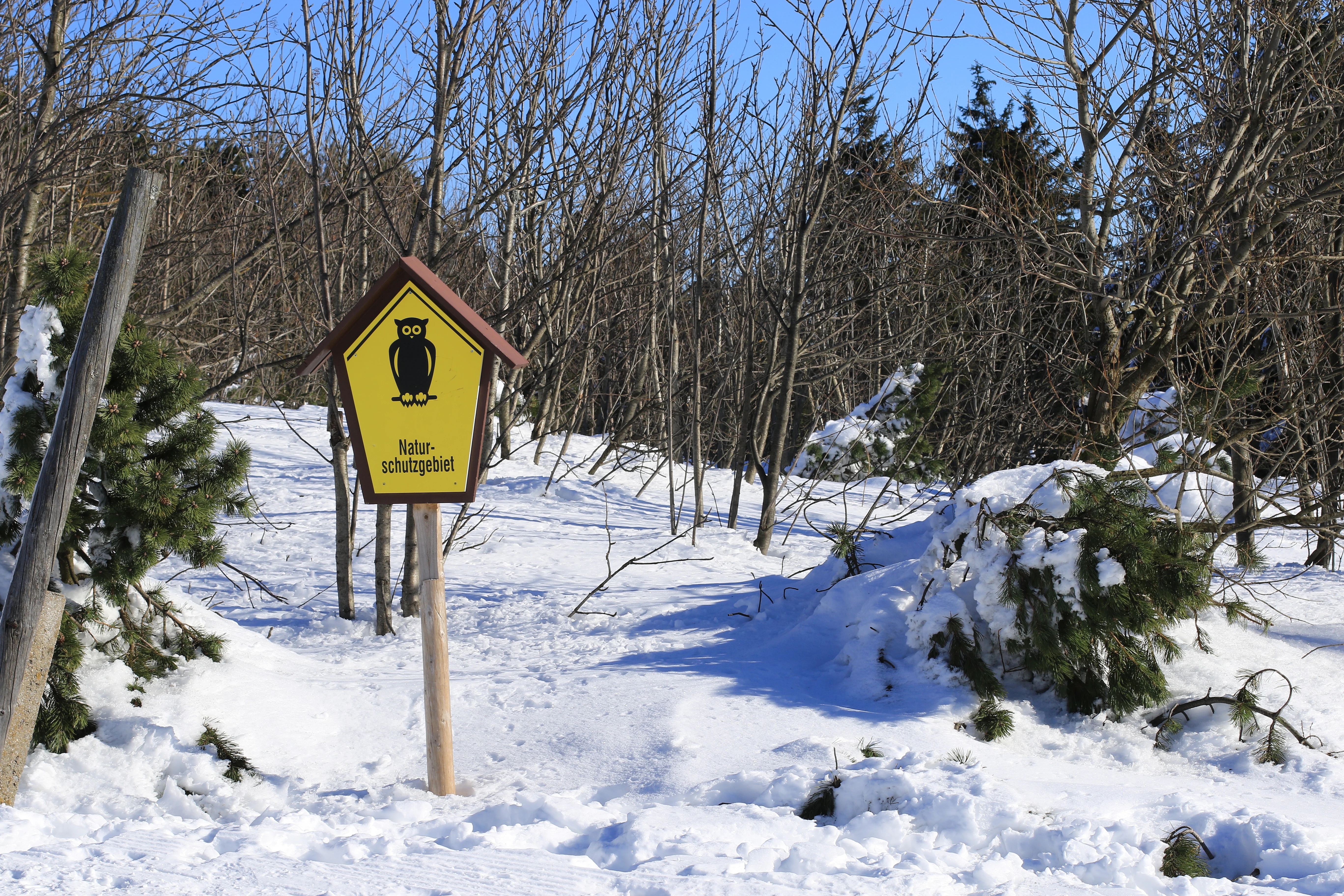
A yellow pentagonal nature reserve sign featuring a black owl silhouette stands on a wooden post in a snowy, wooded environment.
A nature reserve sign stands in the snowy landscape of the Fichtelberg area.

Fichtelberg Nature Reserve history and protected-area timeline

The area now forming Fichtelberg Nature Reserve was historically protected under several separate designations throughout the twentieth and early twenty-first centuries. Pre-existing conservation areas including Zechengrund, Fichtelberg-Südhang, Fichtelberg mit Schönjungferngrund, and Rohr- oder Schilfwiese were combined into a single reserve in order to unify conservation management across the upper Fichtelberg slopes.

Formally designated in 2008 under the designation NSG-Nr. C 98, the reserve consolidated both legal protection status and habitat coverage on Saxony's most prominent mountain summit region. The Börnerwiese, a previously protected natural monument also known for its meadow character, was integrated into the same framework. As a result, the modern reserve reflects a long-standing local recognition of the ecological and landscape value of the Fichtelberg's upper slopes and surrounding valleys.

Fichtelberg Nature Reserve landscape and geographic character

The Fichtelberg landscape lies at the upper edge of the Saxon Erzgebirge, transitioning from broad high-mountain slopes into valley systems, steep streambanks, and raised bog plateaus. The terrain is shaped by long glacial influence, producing the distinctive rounded frost-pattern ground structures known as Beerhübl across portions of the reserve. These features create small-scale topographic variation that supports unique vegetation communities and provides insight into ice-age processes that shaped the upper Erzgebirge.

The reserve's network of small mountain streams and spring systems further defines its terrain. Narrow valleys lined with subalpine tall-herb vegetation alternate with waterlogged mires on flatter sections, producing the compressed patchwork of contrasting habitats that characterizes the Fichtelberg upper slopes. The position of the area along the German-Czech border also gives the landscape a transboundary ecological character, with habitats extending across the state line into the Czech Ore Mountains.

Fichtelberg Nature Reserve ecosystems, habitats, and plant life

Ecologically, Fichtelberg Nature Reserve preserves a distinctive blend of montane and submontane habitats that is increasingly rare in the central Erzgebirge. Mountain meadows represent the most visually striking type, producing extensive seasonal blooms of grasses and flowering plants that depend on traditional low-intensity land management. Below these open meadows, Nardus grasslands and mountain heaths form vegetation types that have become strongly reduced across much of central Europe but still persist in the protected area.

Wetland systems form an equally important component. The reserve contains springs, transition mires, and lowland mires, including species known from limited subalpine locations further south. These habitats are tied tightly to the area's hydrology, with cold, slow-moving waters feeding into bog communities that have developed over long ecological timescales. Combined with near-natural montane spruce forests, these vegetation types compose a habitat mosaic rarely encountered elsewhere in Saxony.

Fichtelberg Nature Reserve wildlife and species highlights

The wildlife of Fichtelberg Nature Reserve reflects the elevated, cold-climate character of the upper Erzgebirge. Reptiles include the common European adder, an important predator of small mammals and a conservation-relevant species in Saxony's upland habitats. Birdlife is particularly noteworthy, with species such as the ring ouzel, an upland thrush associated with open montane and submontane slopes, recorded within the reserve.

The corncrake, a globally declining meadow specialist strongly tied to traditional grassland management, is documented as one of the reserve's distinctive bird species. Among invertebrates, the moorland clouded yellow butterfly represents another noteworthy presence that reinforces the area's significance as a habitat for species linked to the high Erzgebirge's remaining mires, meadows, and open grassland ecosystems.

Fichtelberg Nature Reserve conservation status and protection priorities

Conservation in Fichtelberg Nature Reserve focuses on sustaining the ecological integrity of mountain meadows, mires, and relict cold-stage landforms that depend on continued low-intensity land management and minimal disturbance. The reserve falls under IUCN Category IV, a habitat and species management designation that allows active conservation intervention, including grazing and traditional hay-making, to maintain the habitats on which many protected species depend.

By combining formerly separate protected sites into one reserve, conservation management can be coordinated across the upper Fichtelberg landscape, strengthening the long-term survival of fragile communities such as subalpine tall herb communities and bog-margin species. The reserve also plays a notable transboundary conservation role, as its protected habitats connect with comparable ecosystems on the Czech side of the Erzgebirge, contributing to broader central European montane biodiversity goals.

Fichtelberg Nature Reserve cultural meaning and human context

The Fichtelberg region of the Erzgebirge has a long identity as both a borderland landscape and a traditionally used mountain environment, where seasonal grazing and hay-making shaped the cultural character of the upper slopes over centuries. Saxon communities historically used the high meadows and bogs around the Fichtelberg as part of a robust upland farming tradition that produced one of central Europe's most distinct mountain cultural landscapes.

This traditional land management continues to play an essential role in sustaining the reserve's biodiversity today. The presence of the Fichtelberg summit, with its long-standing significance in Saxon identity, also lends a cultural dimension to the protected area, tying modern nature conservation directly to the broader cultural geography of the Erzgebirge.

Top sights and standout views in Fichtelberg Nature Reserve

Fichtelberg Nature Reserve combines several of the central Erzgebirge's rarest high-altitude ecological elements within a single protected framework. Its mountain meadows, mountain heaths, and Nardus grasslands represent vegetation types that have declined dramatically across much of the region.

The reserve's mires, subalpine tall-herb communities, and ice-age frost-pattern soils add distinct geological and ecological value. Together with its documented occurrences of species like the ring ouzel, the corncrake, the moorland clouded yellow, and the common adder, the reserve represents a concentrated showcase of Saxon upland nature, linking ecological, geological, and cultural landscape values into one compact area.

Best time to visit Fichtelberg Nature Reserve

Late spring through early autumn is broadly the most rewarding period for experiencing Fichtelberg Nature Reserve, when flowering mountain meadows and bog-margin vegetation are most visible. Summer brings the richest display of meadow blooms and offers the clearest conditions for observing the open upper slopes around the Fichtelberg summit.

Winter can be evocative as well, when snow highlights the rounded frost-pattern ground structures and the broader high-mountain topography, though the open upland sections around the Fichtelberg can be exposed to harsh weather. Bird activity and meadow plant communities tend to make the warmer months the most ecologically informative period for visitors interested in the reserve's biodiversity.

Monthly climate preview

Long-term representative coordinate records detailing annual weather patterns and monthly variations

Fichtelberg Climate Normals and Measured Monthly Temperature and Precipitation Rhythms

Fichtelberg records measured long-term monthly temperature averages ranging from negative winter minimums to warm summer maximums alongside consistent daily precipitation rates. Examining the full twelve-month profile provides complete insight into the regional climate normals across all recorded coordinate points.
Annual mean7 °C
-3 °C18 °C
Jan-3°
Feb-2°
Mar
Apr
May12°
Jun16°
Jul18°
Aug18°
Sep13°
Oct
Nov
Dec-2°
Warmest month
July

17.8 °C

Coolest month
January

-2.7 °C

Wettest month
July

2.7 mm/day

Driest month
April

1.4 mm/day

Park location guide

Geography guide, regional context, and park location map for Fichtelberg Nature Reserve

Fichtelberg Nature Reserve park geography, regions, and map view in Germany

Understand where Fichtelberg Nature Reserve sits in Germany through a broader geographic reading of the surrounding landscape, nearby location context, and its mapped position within the national park landscape.

How Fichtelberg Nature Reserve fits into Germany

Germany is a federal republic in Western and Central Europe with a population of over 83 million across sixteen constituent states. It is Europe's largest economy by nominal GDP and a major global exporter and importer. The capital is Berlin, and the country borders Denmark, Poland, Czech Republic, Austria, Switzerland, France, Luxembourg, Belgium, and the Netherlands.

Wider geography shaping Fichtelberg Nature Reserve in Germany

Germany is located in Western and Central Europe, spanning 357,022 km². It borders Denmark to the north, Poland and the Czech Republic to the east, Austria and Switzerland to the south, and France, Luxembourg, Belgium, and the Netherlands to the west. The country has coastlines on the Baltic Sea and North Sea to the north, with the Alps located in the southern region.

Map view of Fichtelberg Nature Reserve

Use this park location map to pinpoint Fichtelberg Nature Reserve in Germany, understand its exact geographic position, and read its mapped placement within the surrounding landscape more clearly.

Pigeon | © OpenStreetMap contributors

Location context for Fichtelberg Nature Reserve

Sachsen

Examine high-altitude terrain, montane meadows, and protected habitats across Saxony's highest mountain

Fichtelberg Photos and Landscapes: Visual Exploration of the Erzgebirge Upland Reserve

Visual records capture the high-elevation terrain, spruce forests, and protected mires defining the Erzgebirge uplands around Fichtelberg. Examining these landscapes reveals the intricate mosaic of mountain meadows, frost-pattern soils, and subalpine habitats characterizing the reserve.

A yellow pentagonal nature reserve sign featuring a black owl silhouette stands on a wooden post in a snowy, wooded environment.

Park atlas

Compare adjacent mountain reserves and regional upland geography

Explore Parks Near Fichtelberg and Surrounding Protected Landscapes

Continue exploring protected areas near Fichtelberg by browsing adjacent mountain reserves across the Erzgebirge range. Comparing these neighboring habitats reveals broader regional conservation patterns and connected upland ecosystems.
Nature reserveÚstecký kraj
About 5.6 km away#1 closest

East

Vápenka v Háji u Loučné pod Klínovcem: Nature Reserve and Calcareous Landscape Map

Examining rare flora and industrial heritage in Ústecký kraj.

Vápenka v Háji u Loučné pod Klínovcem protects an 8.37 hectare site defined by its unusual dolomitic geology and history of lime extraction. This landscape hosts a specialized assemblage of critically endangered fungi and plants, offering a distinct contrast to the acidic soils of the surrounding Ore Mountains.

Area
0.084 km²
Established
2024
IUCN
IV
Relief
Mountain
Natural monumentKarlovarský kraj
About 12 km away#2 closest

Southeast

Malý Stolec Natural Monument: Volcanic Landscape and Regional Protected Area Atlas

Exposing neovolcanic rock and ancient feeder conduits in Karlovarský kraj

Malý Stolec provides a focused view into the volcanic processes of the Doupovské hory. This natural monument displays rare geologic features including columnar jointing, coarse agglomeratic tuffs, and an intruded lava body. Its location on the southern slopes above the Ohře river offers a distinct landscape character that demonstrates how localized protected areas contribute to broader European conservation frameworks.

Area
0.06 km²
Established
2016
IUCN
IV
Relief
Mountain
Natural monumentKarlovarský kraj
About 12 km away#3 closest

West

Vlčí jámy Natural Monument: Protected Geological and Industrial Heritage in Bohemia

Ore Mountains mining collapse and relict microclimate landscape

Vlčí jámy protects a rare intersection of medieval mining history and environmental significance in the Karlovarský kraj. The site is defined by two deep collapse features, Ledová jáma and Vlčí jáma, which function as persistent cold traps. These geological anomalies support critically endangered mosses and bat colonies, illustrating how abandoned industrial landscapes in the Ore Mountains evolve into essential, small-scale protected habitats.

Area
0.014 km²
Established
1975
IUCN
III
Relief
Mountain
A horizontal watercolor painting depicting a soft-focus landscape with rolling green meadows, distant hills, and patches of trees.
Natural monumentÚstecký kraj
About 19 km away#4 closest

East

Na loučkách II Natural Monument: Mapped Geography and Protected Upland Landscapes

Conservation areas in the Ore Mountains of the Ústecký kraj

Na loučkách II encompasses a substantial upland territory in the Czech Republic, characterized by a mix of peatland basins, heathland, and montane meadow mosaics. This natural monument serves as an essential ecological link within the Ore Mountains, protecting diverse highland terrain and supporting sensitive habitats in the Ústecký kraj administrative region.

Area
6.623 km²
Established
2013
IUCN
IV
Relief
Highland
A horizontal watercolor illustration depicting a soft, green, mountain landscape with hills, conifers, and a waterlogged meadow.
Natural monumentKarlovy Vary Region
About 20 km away#5 closest

West

Rudenská luční prameniště Natural Monument: Protected Mountain Wetland Atlas

Karlovy Vary Region Ore Mountains landscape mapping

Rudenská luční prameniště is a protected mountain wetland in the Ore Mountains, defined by a distinct mosaic of spring fens, peat deposits, and mountain meadows. Its geographic layout, spanning twenty three hectares across sloping terrain, creates a vital drainage system for the local landscape. By examining this protected site, you can better understand the unique hydrological and botanical features that distinguish these rare mountain mire complexes from the surrounding highland forests.

Area
0.232 km²
Established
2020
IUCN
IV
Relief
Mountain
Nature reserveSachsen
About 20 km away#6 closest

West

Friedrichsheider Hochmoor Nature Reserve: Geography and Protected Bog Landscape in Sachsen

High-elevation peatland and bog pine forest mapping

Situated at 800 meters above sea level near Sosa, Friedrichsheider Hochmoor serves as a cornerstone of peatland conservation in the Erzgebirge. This reserve is defined by its thick peat body and dense Spirken moor forest, offering a rare look at near-intact mire ecosystems that support diverse Sphagnum mosses and subarctic plant communities within a protected regional framework.

Area
0.19 km²
Established
1967
IUCN
IV
A horizontal watercolor painting showing a soft, atmospheric landscape with a marshy pool in the foreground, grassy plains in the midground, and rolling mountains in the distance.
Nature reserveÚstecký kraj
About 21 km away#7 closest

Northeast

Prameniště Chomutovky: Nature Reserve Boundaries and Regional Landscape Context

Protected peatland ecosystems in the Czech Republic

Prameniště Chomutovky serves as a pivotal protected area in the Ore Mountains, characterized by its deep peat deposits and open bog-pine mosaics. This documentation of the reserve includes its role as a black grouse habitat, its connection to the Novodomské rašeliniště network, and the distinct geomorphology that shapes its montane environment.

Area
18.82 km²
Established
2012
IUCN
IV
Relief
Mountain
Nature reserveSachsen
About 21 km away#8 closest

Northwest

Conradswiese Nature Reserve: Geographic Overview of the Saxon Ore Mountains Forest Meadow

Protected mountain meadow and mixed forest terrain in Sachsen.

Conradswiese encompasses a distinct Waldwiese clearing embedded within the Bergmischwald of the western Ore Mountains. Located near the Morgenleithe, this nature reserve is positioned along a watershed boundary between two river systems, making it a point of geographic interest for those exploring the natural heritage and silvicultural history of Germany.

Area
38.97 km²
IUCN
IV

Common questions about visiting, size, designation, and location context for Fichtelberg Nature Reserve

Fichtelberg Nature Reserve FAQs for park facts, access, geography, and protected area context

Find quick answers about Fichtelberg Nature Reserve, including protected-area facts, park geography, trail and visitor context, and how the park fits into its surrounding country and regional landscape.
MoriAtlas Explorer

Continue Your Protected Areas Search Across the Global Atlas

Deepen your exploration by continuing the structured search for national parks and protected areas worldwide. Utilize the comprehensive filtering capabilities to compare different conservation landscapes and refine your understanding of global park geography. Discover more about the distribution and characteristics of protected natural areas.

Global natural geography