
Mori Atlas logo
Protected areaFlaming Gorge National Recreation Area

A detailed look at the protected reservoir landscape, shoreline geography, and canyon terrain across the Wyoming and Utah border.

Flaming Gorge National Recreation Area: Mapping the Red Sandstone Canyons and Green River Geography

Flaming Gorge National Recreation Area occupies a distinct corridor of high desert plateaus, forested mountain slopes, and winding water channels along the Green River. This protected landscape is defined by the vivid red sandstone cliffs that frame the long reservoir, creating a striking interface between hydroelectric water management and rugged canyon topography. The following data details the park's physical boundaries, its role within the Ashley National Forest, and the geological features that distinguish this prominent western water corridor.

reservoircanyonred sandstone cliffsGreen Riverhydroelectric damnational recreation area
A digital illustration of a landscape featuring red sandstone cliffs dropping into a blue reservoir, with green hills in the foreground and a pale sky.

Flaming Gorge National Recreation Area

Protected area

Park overview

Structured park overview, official facts, and landscape profile for Flaming Gorge National Recreation Area

Flaming Gorge National Recreation Area park facts, protected area profile, and essential visitor context

Review the core facts for Flaming Gorge National Recreation Area, including designation, size, terrain, visitor scale, habitats, and operating context in one park-focused overview.

About Flaming Gorge National Recreation Area

Flaming Gorge National Recreation Area is a large federal recreation landscape that follows the Green River across the high country where southwestern Wyoming meets northeastern Utah. The defining geography of the area is the long, sinuous Flaming Gorge Reservoir, which fills roughly 91 miles of canyon country and creates a continuous corridor of water, cliff, forest, and desert under a single management umbrella.

The recreation area was carved out of a landscape with a long human and natural history. The Green River, which shaped the canyons long before the reservoir arrived, was famously explored by John Wesley Powell in 1869, and it was Powell who bestowed the name Flaming Gorge on this stretch of river. The vivid red sandstone walls he described remain the single most recognizable feature of the place today, glowing especially strongly in the lower-angle light of morning and evening.

The modern character of the recreation area was defined in the mid-twentieth century by the construction of Flaming Gorge Dam, completed in 1964 across the Green River. The dam both created the reservoir and established hydroelectric generation as a key function of the site, with three generators at its base producing a large combined capacity of electrical power. In 1968, an act of Congress formally designated the surrounding lands as a National Recreation Area, ensuring that the reservoir, the canyon scenery, and the surrounding forests would be managed together for public enjoyment.

Today, Flaming Gorge is administered by the U.S. Forest Service as part of the Ashley National Forest, which gives it a strong backcountry character alongside its water-based appeal. Visitors encounter a layered environment: lake and shoreline recreation on the reservoir, rugged canyon scenery along cliffs and overlooks, forested hills typical of the Ashley National Forest, and stretches of the Green River downstream of the dam that retain a wild, flowing character suitable for rafting. The result is a recreation area that feels both engineered and deeply rooted in the natural canyon landscape of the intermountain West.

Quick facts and research context for Flaming Gorge National Recreation Area

Flaming Gorge National Recreation Area lies across Sweetwater County in Wyoming and Daggett County in Utah, with the nearest city being Green River, Wyoming. It encompasses roughly 207,000 acres of canyon, lake, forest, and high desert terrain, anchored by the 91-mile Flaming Gorge Reservoir.

Established as a National Recreation Area by an act of Congress on October 1, 1968, the area is managed by the U.S. Forest Service through the Ashley National Forest. Its creation followed the 1964 completion of Flaming Gorge Dam, which impounds the Green River and also generates hydroelectric power.

Protection and recognition

Official terrestrial designation metrics established in 1968.

Flaming Gorge National Recreation Area Protection Status and History

Comprehensive protected area records outline the conservation framework and designation history established for Flaming Gorge National Recreation Area in 1968. Structured facts detail the terrestrial management scope and administrative milestones for this protected landscape.

Protection details

Protection scope
Terrestrial
Designated year
1968
Transboundary protection
No
Park context

Deeper park guide and search-rich context for Flaming Gorge National Recreation Area

Flaming Gorge National Recreation Area history, landscape, wildlife, and travel context

Explore Flaming Gorge National Recreation Area through its history, landscape character, ecosystems, wildlife, conservation priorities, cultural context, and seasonal travel timing in a structured park guide built for atlas discovery and search intent.

Why Flaming Gorge National Recreation Area stands out

Flaming Gorge is best known for the dramatic red sandstone canyon scenery that surrounds the Flaming Gorge Reservoir, a long, narrow lake that winds through the highlands of southwestern Wyoming and northeastern Utah. The vivid cliffs, captured in early exploration accounts by John Wesley Powell in 1869, give the place both its name and its enduring visual identity. Beyond its scenery, the area is recognized for combining a major water-based recreation destination with a working hydroelectric dam, creating a landscape where canyon geology, river history, and outdoor recreation converge along the Green River corridor.
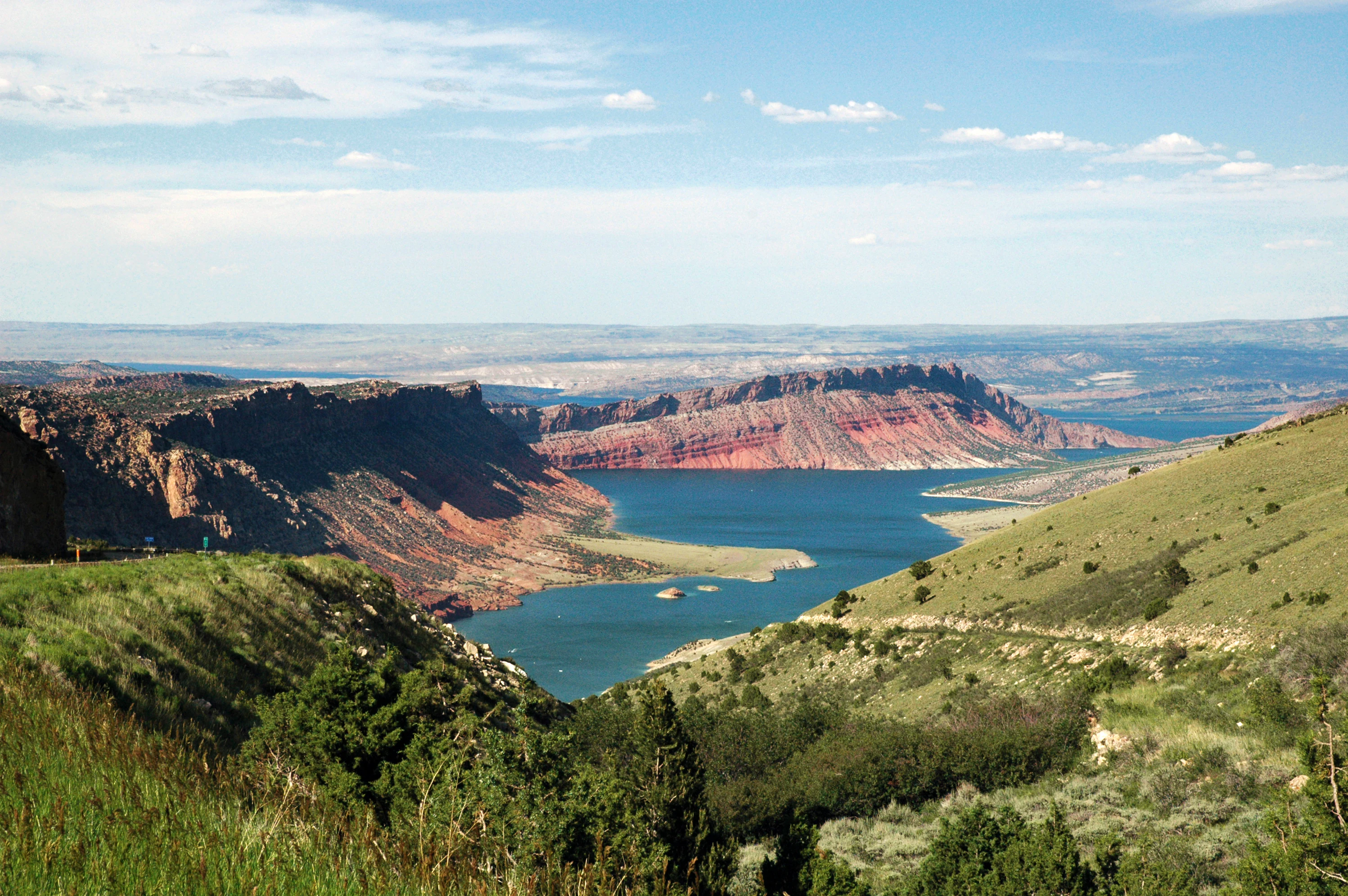
A high vantage view of a blue reservoir nestled between high red sandstone cliffs and sloping green, shrub-covered hillsides under a partly cloudy sky.
A view overlooking the blue waters and red sandstone cliffs of Flaming Gorge Reservoir, captured from the Sheep Creek Overlook.

Flaming Gorge National Recreation Area history and protected-area timeline

The human story of Flaming Gorge begins with the Green River itself. The canyon country along this stretch of the river was named Flaming Gorge by John Wesley Powell during his historic 1869 expedition down the Green River, when he encountered the spectacular red sandstone cliffs that line the gorge. Powell's naming gave the landscape an identity that has endured for more than a century and a half.

For most of the nineteenth and early twentieth century, the area remained a remote canyon environment, known primarily to trappers, ranchers, river explorers, and travelers crossing the high country between Wyoming and Utah. It was not until the mid-twentieth century that the larger transformation of the Green River took shape.

In 1964, the Flaming Gorge Dam was completed across the Green River, impounding the waters behind it to form the Flaming Gorge Reservoir. The dam fundamentally reshaped the geography of the region, converting the flowing river canyon into a long, calm lake stretching into both Wyoming and Utah. At the same time, the dam introduced a major new function to the landscape: hydroelectric power generation, with three turbines and generators at its base.

Four years later, on October 1, 1968, Congress formally established the surrounding lands as the Flaming Gorge National Recreation Area. This designation protected the reservoir and its scenic backdrop as a unified federal recreation landscape, placing it under the management of the U.S. Forest Service through the Ashley National Forest. Since then, Flaming Gorge has functioned as one of the major reservoir-based recreation destinations of the American West, where the legacy of Powell's exploration, mid-twentieth-century dam-building, and modern outdoor recreation all meet along the Green River.

Flaming Gorge National Recreation Area landscape and geographic character

The landscape of Flaming Gorge is defined by the interplay between water, canyon, and high country. The centerpiece, Flaming Gorge Reservoir, is a long and narrow lake that fills roughly 91 miles of canyon country, following the path of the Green River as it cuts between Wyoming and Utah. The reservoir's surface runs through steep valleys and broad basins, creating a continuously changing shoreline framed by forested slopes, rocky ridges, and exposed cliff walls.

Above all, the landscape is marked by the red sandstone cliffs that gave the area its name. These formations stand out vividly against the surrounding terrain, glowing in warm tones during sunrise and sunset and creating dramatic vertical faces along much of the gorge. The cliffs are not uniform; they shift in color, layering, and exposure as the reservoir winds through the surrounding plateau, producing a varied visual experience along different stretches of the shoreline.

Surrounding the reservoir and its canyon walls, the broader landscape transitions into the higher, forested terrain characteristic of the Ashley National Forest. Here, stands of conifer, scattered aspen groves, and open meadows soften the canyon edges and provide a contrasting backdrop to the arid red rock below. Downstream of Flaming Gorge Dam, the Green River resumes a more traditional river character, running through the gorge as a flowing river rather than a reservoir, and the canyon landscape continues to define the scenery. Together, the lake, cliffs, forests, and river corridor create a recreation area where water, geology, and elevation all contribute to a distinctive western landscape.

Flaming Gorge National Recreation Area ecosystems, habitats, and plant life

Flaming Gorge sits within a transitional ecological zone where high desert, canyon country, and montane forest meet. The reservoir and the Green River corridor support aquatic and riparian habitats that contrast with the drier uplands above the canyon rim, creating a layered environment of plant and animal communities across a relatively compact geographic range.

Forests associated with the Ashley National Forest, including coniferous stands and aspen groves, occupy the higher elevations and shaded slopes around the reservoir. These forested patches provide habitat for a range of mountain and woodland species and contribute to the green character of much of the shoreline. In contrast, the exposed canyon walls and lower elevations feature drier vegetation typical of the intermountain West, including scrub, grassland, and sparse woodland adapted to arid conditions.

The reservoir itself has reshaped local ecological conditions, turning a previously flowing canyon river into a large standing body of water with its own shoreline habitats and aquatic communities. Below the dam, the Green River continues as a flowing river system, supporting a separate set of riparian and aquatic conditions. This combination of lake, canyon cliffs, forested slopes, and a free-flowing river downstream gives Flaming Gorge a complex ecological profile unusual for a recreation area of its kind.

Flaming Gorge National Recreation Area wildlife and species highlights

The wildlife profile of Flaming Gorge reflects the diversity of habitats found across the recreation area. The mix of reservoir, free-flowing river, canyon cliffs, forested slopes, and arid uplands supports a broad range of mammal, bird, and fish species typical of the southern Wyoming and northeastern Utah borderlands.

The reservoir is a central feature for fish and aquatic life, supporting fish populations that have made Flaming Gorge a major destination for anglers. The river reaches downstream of the dam retain a different aquatic character, supporting fish and invertebrates adapted to flowing water. Along the shorelines and surrounding lands, typical wildlife of the intermountain West is present, including mule deer and other large mammals that move between forested and open terrain.

Birdlife is significant across the recreation area, with raptors, waterbirds, and montane forest species all finding habitat within its boundaries. Canyon cliffs offer nesting and perching opportunities for birds of prey, while the reservoir and its margins attract waterfowl and shorebirds, and the forested uplands host woodland songbirds and other forest-dependent species. This combination gives Flaming Gorge a varied and ecologically meaningful wildlife presence well beyond its recreational appeal.

Flaming Gorge National Recreation Area conservation status and protection priorities

Flaming Gorge National Recreation Area is significant from a conservation perspective because it preserves a large, contiguous corridor of canyon, reservoir, forest, and high desert under a single federal designation. By linking the Flaming Gorge Reservoir and the surrounding lands into one protected landscape, the recreation area safeguards scenery, habitat, and recreational value across a substantial portion of the Green River drainage.

The 1968 designation followed on the 1964 completion of Flaming Gorge Dam, recognizing that the newly created reservoir and the dramatic canyon scenery around it deserved coordinated federal protection rather than fragmented management. Placing the area under the U.S. Forest Service through the Ashley National Forest ensured that forests, cliffs, waterways, and wildlife habitat would be administered together.

The conservation value of the area extends beyond formal protection. The reservoir and downstream Green River together sustain aquatic ecosystems; the canyon walls and forested slopes shelter wildlife; and the broader landscape continues to function as a working example of how a hydropower reservoir, a national recreation mandate, and natural scenery can coexist in the American West.

Flaming Gorge National Recreation Area cultural meaning and human context

Flaming Gorge carries cultural weight that extends well beyond its modern recreational identity. The name itself is a direct legacy of John Wesley Powell's 1869 expedition down the Green River, an event that was foundational to the geographic and scientific understanding of the American West. Powell's vivid description of the red sandstone cliffs helped define how Americans imagine this stretch of the canyon country.

The area also reflects the broader twentieth-century story of dam-building and water development in the western United States. The construction of Flaming Gorge Dam transformed both the river and the surrounding landscape, marking a major chapter in the relationship between engineering, energy production, and public lands in the intermountain West. Together, these threads of exploration and modern development give Flaming Gorge a layered cultural identity that complements its scenic and ecological importance.

Top sights and standout views in Flaming Gorge National Recreation Area

The single most striking highlight of Flaming Gorge is the combination of the long Flaming Gorge Reservoir with the vivid red sandstone cliffs that line so much of its shoreline, the same feature that prompted John Wesley Powell to give the place its name in 1869. This visual pairing, calm water set against glowing canyon walls, defines the recreation area and distinguishes it from other reservoir destinations in the region.

Equally important is the recreation area's ability to offer multiple experiences within a single landscape: lake-based recreation on the reservoir, rugged canyon scenery along its overlooks, forested terrain typical of the Ashley National Forest, and a genuinely wild stretch of the Green River downstream of the dam suitable for rafting. The integration of hydroelectric infrastructure, large federal protection, and a deep historical identity tied to Powell's exploration rounds out the area's distinctive profile.

Best time to visit Flaming Gorge National Recreation Area

Flaming Gorge's character shifts meaningfully with the seasons, which makes timing an important part of any visit. Summer is the most active period, when warmer temperatures, long daylight hours, and stable water conditions support boating, fishing, camping, hiking, and water-based recreation across the reservoir and surrounding lands. The reservoir's shoreline, marinas, and campgrounds come fully to life during these months.

Spring and autumn offer a quieter, more atmospheric experience. Cooler temperatures, fewer crowds, and changes in forest color, particularly in the aspen stands within the Ashley National Forest, can make the canyon scenery feel especially vivid. The red sandstone cliffs also take on deeper tones during the lower-angle light of these seasons.

Winter brings a colder, more subdued character to the recreation area, with snow possible at higher elevations and reduced access to some facilities. For visitors primarily interested in scenery and solitude rather than active water recreation, the shoulder seasons and even winter can reveal a more contemplative side of Flaming Gorge, while summer remains the most rewarding time for full use of the reservoir.

Monthly climate preview

Long-term temperature and precipitation normals recorded across representative coordinates

Flaming Gorge National Recreation Area Climate Profile and Monthly Weather Patterns

Recorded measurements at Flaming Gorge National Recreation Area reveal a wide annual temperature range alongside modest monthly precipitation rates spanning from winter lows to summer highs. Reviewing the complete monthly climate normals provides a deeper look into the long-term meteorological rhythm of this protected region.
Annual mean6 °C
-6 °C21 °C
Jan-6°
Feb-4°
Mar
Apr
May10°
Jun16°
Jul21°
Aug19°
Sep14°
Oct
Nov-1°
Dec-6°
Warmest month
July

20.9 °C

Coolest month
January

-6.2 °C

Wettest month
May

1.2 mm/day

Driest month
January

0.6 mm/day

Park location guide

Geography guide, regional context, and park location map for Flaming Gorge National Recreation Area

Flaming Gorge National Recreation Area park geography, regions, and map view in United States of America

Understand where Flaming Gorge National Recreation Area sits in United States of America through a broader geographic reading of the surrounding landscape, nearby location context, and its mapped position within the national park landscape.

How Flaming Gorge National Recreation Area fits into United States of America

The United States of America is a federal presidential republic and one of the world's largest countries by area and population. It consists of 50 states across a vast territory spanning multiple time zones, with its capital in Washington, D.C. and largest city in New York City. The nation has a diverse economy, influential political system, and significant cultural and military presence globally.

Wider geography shaping Flaming Gorge National Recreation Area in United States of America

The United States occupies a vast territory in North America, bordered by Canada to the north and Mexico to the south. The 48 contiguous states stretch from the Atlantic to the Pacific Ocean, while Alaska occupies the northwestern region and Hawaii is an archipelago in the Pacific. The country encompasses diverse terrain including the Rocky Mountains, Appalachian Mountains, Great Plains, and extensive river systems.

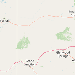
Map view of Flaming Gorge National Recreation Area

Use this park location map to pinpoint Flaming Gorge National Recreation Area in United States of America, understand its exact geographic position, and read its mapped placement within the surrounding landscape more clearly.

Pigeon | © OpenStreetMap contributors

Location context for Flaming Gorge National Recreation Area

UtahWyoming
Natural feature types

Continue Discovering Flaming Gorge National Recreation Area Natural Features

Explore the specific geological and hydrological landmarks that shape this massive recreation area. MoriAtlas provides a structured look at the reservoir segments, canyon walls, and river paths that define the regional geography of Flaming Gorge National Recreation Area.
Recorded earthquake history

Examine the Recorded Earthquake History of Flaming Gorge National Recreation Area

Access a structured, historical catalogue of seismic events recorded in the vicinity of Flaming Gorge National Recreation Area. MoriAtlas provides these USGS-derived records to help researchers and enthusiasts trace regional earthquake history, magnitudes, and epicentre locations without drawing conclusions on current seismic trends.

Flaming Gorge National Recreation Area Earthquake History

Catalogued events

59 events

Strongest magnitude

Magnitude 4.3

Most recent event

Sep 15, 2026

This history includes earthquakes recorded inside the park or within 50 km of its borders

Visual reference collection highlighting dramatic sandstone cliffs and water corridors

Flaming Gorge National Recreation Area Photos and Red Rock Canyon Scenery

Visual records capture the striking red sandstone cliffs, winding reservoir waters, and high desert terrain that define the protected landscape. Examining these field photographs reveals the distinctive geological formations and forested upland environments spanning the regional boundary.

A high vantage view of a blue reservoir nestled between high red sandstone cliffs and sloping green, shrub-covered hillsides under a partly cloudy sky.

A wide-angle landscape view showing a large reservoir winding through a canyon with steep, reddish-brown cliffs on one side and a forested slope on the other.

Park atlas

Compare regional geography, canyon terrain, and adjacent protected areas across the intermountain West.

Parks Near Flaming Gorge National Recreation Area and Surrounding Protected Landscapes

Browsing other parks near Flaming Gorge National Recreation Area reveals connected canyon country, high desert terrain, and regional watershed ecosystems. Comparing adjacent protected areas provides a broader geographical perspective on the intermountain West landscape.
Watercolor painting of a peaceful mountain valley landscape, showing a small winding stream in the foreground, grassy meadows, clusters of pine trees, and rolling mountain peaks in a soft, sunset-colored sky.
Protected landscapeWyoming
117 km away#1 closest

North

Shoshone National Forest: A Comprehensive Map and Geography of America's Oldest National Forest

Rugged wilderness and glacial peaks in Wyoming

Discover the immense geographic scale of Shoshone National Forest, which protects a diverse landscape ranging from sagebrush valleys to 13,000-foot granite summits. This atlas overview details its role within the Greater Yellowstone Ecosystem and its expansive, federally designated wilderness areas, offering a clear perspective on its volcanic and glacial terrain.

Area
9,992.69 km²
Established
1891
IUCN
VI
Visitors
500K annual
A pale, wide watercolor landscape illustration depicting mountain peaks above a line of evergreen trees and a flat foreground.
Protected areaWyoming
129 km away#2 closest

North

Popo Agie Wilderness: Protected Landscapes in the Wyoming Wind River Range

High-altitude alpine terrain and glacial basins

The Popo Agie Wilderness in Wyoming encompasses a dramatic vertical landscape, ranging from forested valleys to alpine summits above 13,000 feet. This protected area features the iconic Cirque of the Towers, dense hydrological networks of glacial tarns, and expansive granite formations that anchor its identity within the Greater Yellowstone Ecosystem.

Area
412.3 km²
Established
1984
IUCN
Ib
Relief
Mountain
A soft, minimalist watercolor painting of a serene lake nestled among rolling hills under a gentle, pastel-toned sky.
Protected landscapeWyoming
165 km away#3 closest

North

Fitzpatrick Wilderness: Exploring the Rugged Protected Landscapes of Western Wyoming

A core alpine environment within the Wind River Range.

Fitzpatrick Wilderness represents one of the most uncompromisingly wild segments of the Wind River Range, featuring persistent glaciers, dramatic U-shaped valleys, and high granite spires. This protected landscape offers a deep look into the alpine geography of Wyoming, preserved under the Wilderness Act to maintain its rugged character, remote glacial cirques, and intricate mountain ecosystems.

Area
803.4 km²
Established
1976
IUCN
Ib
Relief
Mountain
A watercolor painting showing a panoramic view of rolling green mountains with a winding stream through a forested valley.
Protected landscapeUtah
166 km away#4 closest

Southwest

Manti, La Sal National Forest: Geographic Overview of Utah's Mountain and Canyon Landscapes

Mapped protected forest boundaries across the Colorado Plateau

Spanning over one million acres, Manti, La Sal National Forest defines a critical segment of Utah geography. This protected landscape encompasses diverse terrain including subalpine mountains, aspen-rich uplands, and deep canyon networks. Use this atlas to examine the distinct environmental characteristics that separate the northern forested plateaus from the southern wilderness canyons.

Area
5,143.09 km²
Established
1950
IUCN
V
Visitors
900K annual
A soft watercolor illustration depicting layered green hills in the foreground with faint mountain outlines in the background against a white background.
Wildlife reserveUtah
168 km away#5 closest

West

Mount Timpanogos Wilderness: Mapping the Protected Alpine Landscape and High Wasatch Terrain

An iconic Utah protected area within the northern Wasatch Range.

Mount Timpanogos Wilderness preserves a dramatic segment of the Wasatch Range, centering on an iconic summit that rises above glacial basins and forested slopes. This protected area offers a distinct study of alpine geology, featuring high-altitude cirques, steep ridges, and the prominent presence of Emerald Lake. As a critical piece of Utah wilderness, it anchors the skyline above the urban corridor, providing a concentrated look at regional mountain ecosystems and rugged natural terrain.

Area
42.56 km²
Established
1984
IUCN
Ib
Relief
Mountain
Wildlife reserveUtah
168 km away#6 closest

West

Lone Peak Wilderness: Protected Alpine Geography and Wasatch Range Map Insights

Rugged glacial terrain and granite summits in Northern Utah

Lone Peak Wilderness represents a dramatic intersection of high-mountain wilderness and urban geography. Rising from the Salt Lake and Utah Valleys, its alpine terrain features jagged granite peaks, persistent snowfields, and steep glacial canyons. This protected landscape remains a critical reference for understanding the ecological and topographical character of the central Wasatch Range and Utah's wilderness preservation history.

Area
121.76 km²
Established
1978
IUCN
Ib
Relief
Mountain
Wildlife reserveUtah
173 km away#7 closest

Northwest

Mount Naomi Wilderness: Mapping High-Altitude Protected Landscapes in Northern Utah

Alpine summits, forested ridges, and subalpine lake basins

Situated in the Bear River Range of northern Utah, Mount Naomi Wilderness stands as a protected corridor of rugged mountain terrain. This wilderness area preserves a diverse high-elevation environment, spanning from the steep western canyons of the Logan River to the prominent summits of Naomi Peak. It serves as a vital point of geographic interest for understanding the subalpine ecosystems and wilderness boundaries within the Uinta-Wasatch-Cache National Forest.

Area
180.18 km²
Established
1984
IUCN
Ib
Relief
Mountain
A pale watercolor painting showing a wide, panoramic view of layered mountains with light green and muted red hills in the foreground and clusters of pine trees.
Wildlife reserveUtah
About 174 km away#8 closest

West

Mount Olympus Wilderness: Geographic Overview of the Iconic Wasatch Range Protected Landscape

Steep granite massif and alpine terrain in northern Utah

Explore the distinct topography of Mount Olympus Wilderness, a protected sanctuary in Utah featuring soaring granite outcrops and deep drainage systems. The park is anchored by a recognizable twin-peak silhouette that rises abruptly from the Salt Lake Valley, encompassing high alpine ridges and one of the deepest known cave systems in the United States within its rugged forested boundaries.

Access
Easy access

Common questions about visiting, size, designation, and location context for Flaming Gorge National Recreation Area

Flaming Gorge National Recreation Area FAQs for park facts, access, geography, and protected area context

Find quick answers about Flaming Gorge National Recreation Area, including protected-area facts, park geography, trail and visitor context, and how the park fits into its surrounding country and regional landscape.
MoriAtlas Explorer

Continue Your Protected Areas Search Across the Global Atlas

Deepen your exploration by continuing the structured search for national parks and protected areas worldwide. Utilize the comprehensive filtering capabilities to compare different conservation landscapes and refine your understanding of global park geography. Discover more about the distribution and characteristics of protected natural areas.

Global natural geography