Mori Atlas logo
Marine protected areaFlower Garden Banks National Marine Sanctuary

Understanding the unique marine protected area boundaries and underwater terrain in the Gulf of Mexico

Flower Garden Banks National Marine Sanctuary: Mapped Coral Reefs and Underwater Salt Dome Geography

Flower Garden Banks National Marine Sanctuary protects a series of thriving coral reef communities located on isolated underwater salt dome formations in the northwestern Gulf of Mexico. This expansive marine protected area spans multiple reefs off the Texas coast, offering a distinct look at seafloor topography and deep-water ecosystems that have developed over millennia. Discover the geographic scope of this offshore sanctuary, from the primary East and West banks to the network of protected reef habitats established through recent regional expansion.

marine sanctuarycoral reefGulf of Mexicounderwater habitatsalt dome banksseamounts

Flower Garden Banks National Marine Sanctuary

Marine protected area

Park overview

Structured park overview, official facts, and landscape profile for Flower Garden Banks National Marine Sanctuary

Flower Garden Banks National Marine Sanctuary park facts, protected area profile, and essential visitor context

Review the core facts for Flower Garden Banks National Marine Sanctuary, including designation, size, terrain, visitor scale, habitats, and operating context in one park-focused overview.

About Flower Garden Banks National Marine Sanctuary

Flower Garden Banks National Marine Sanctuary protects a striking cluster of underwater mountains rising from the seafloor of the northwestern Gulf of Mexico. Although the banks lie about 100 nautical miles from the Texas coast, they sit at depths shallow enough to support dense reef communities, making them an unusual and ecologically valuable outpost of Caribbean-style marine life far north of where most Western Atlantic reefs occur.

The reefs grew on geological foundations formed when massive subsurface salt deposits migrated upward, deforming overlying sediments into domes and ridges. As sea levels rose after the last glacial period, the elevated crests of these structures came within the depth range where reef-building corals could thrive. Coral communities colonized the banks somewhere between 10,000 and 15,000 years ago and have persisted ever since, forming complex three-dimensional habitats that shelter an extraordinary diversity of marine life.

Originally established around two main banks, East Flower Garden Bank and West Flower Garden Bank, the sanctuary expanded in 1996 to include nearby Stetson Bank. A much larger expansion in 2021 brought 14 additional reefs and banks under protection, nearly tripling the total managed area. Today, the sanctuary encompasses a network of discrete reef patches scattered across the open Gulf, each contributing to a regionally important system of healthy coral cover and associated fish populations.

Beyond their biological richness, the Flower Garden Banks play an outsized role in scientific research. Long-term monitoring programs track reef health, climate impacts, and ecosystem changes, making the sanctuary one of the best-studied offshore reef systems in the United States. Its remote setting, intact reef framework, and protected status together provide a benchmark for understanding coral resilience in a changing ocean.

Quick facts and research context for Flower Garden Banks National Marine Sanctuary

Flower Garden Banks National Marine Sanctuary lies in the northwestern Gulf of Mexico about 100 nautical miles southeast of Galveston, Texas. It was designated in 1992 as the tenth U.S. National Marine Sanctuary and is managed by NOAA's National Ocean Service.

The sanctuary protects a network of submerged ocean banks formed where ancient salt domes pushed the seafloor upward. East Flower Garden Bank and West Flower Garden Bank joined the sanctuary in 1992, Stetson Bank was added in 1996, and a major NOAA expansion in 2021 grew the protected area from roughly 56 to 160 square miles by including 14 additional reefs and banks.

Protection and recognition

Marine protected area management scope and recognition records

Flower Garden Banks National Marine Sanctuary Protection Status

Marine protection status and management scope define the baseline conservation framework for Flower Garden Banks National Marine Sanctuary. Official documentation tracks designated boundaries and international recognition records without assuming external ecological outcomes.

Protection details

Protection scope
Marine
Park context

Deeper park guide and search-rich context for Flower Garden Banks National Marine Sanctuary

Flower Garden Banks National Marine Sanctuary history, landscape, wildlife, and travel context

Explore Flower Garden Banks National Marine Sanctuary through its history, landscape character, ecosystems, wildlife, conservation priorities, cultural context, and seasonal travel timing in a structured park guide built for atlas discovery and search intent.

Why Flower Garden Banks National Marine Sanctuary stands out

The sanctuary is best known for hosting the northernmost well-developed coral reefs in the United States, on isolated salt dome banks far offshore in the Gulf of Mexico. These reefs are considered among the healthiest in the Caribbean and Western Atlantic because of clear offshore water, stable substrates, and minimal direct coastal stressors. It is also renowned for recurrent mass coral spawning events, the rare golden color phase of the smooth trunkfish, and its importance as a nursery area for large pelagic species such as oceanic manta rays and schooling spotted eagle rays.
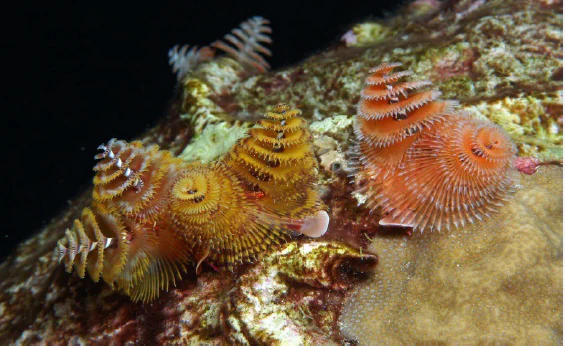
Close-up underwater view of vibrant orange and yellow spiral-shaped Christmas tree worms emerging from a textured coral reef surface against a dark background.
Colorful Christmas tree worms attached to a coral head in the Flower Garden Banks National Marine Sanctuary.

Flower Garden Banks National Marine Sanctuary history and protected-area timeline

The first modern scientific awareness of the Flower Garden Banks came in 1936, when the U.S. Coast and Geodetic Survey mapped East Flower Garden Bank, West Flower Garden Bank, and Stetson Bank as part of a broader hydrographic survey of the Gulf of Mexico. Follow-up surveys in the 1950s confirmed that the banks were the surface expression of underlying salt dome geology rather than ordinary seafloor features.

Throughout the mid-twentieth century, researchers debated whether coral reefs could survive in the offshore Texas region, given concerns over cold water temperatures and sediment-laden conditions. Beginning in the early 1960s, a series of scientific scuba expeditions finally revealed that both East and West Flower Garden Bank supported extensive reef communities. These expeditions laid the groundwork for the Flower Gardens Ocean Research Center, established in the late 1960s, which became a hub for ongoing reef research and eventually for conservation advocacy.

National marine sanctuary legislation, beginning with the Marine Protection, Research, and Sanctuaries Act of 1972, opened the door to formal protection. The Houston Underwater Club formally nominated the Flower Garden Banks as a sanctuary in 1979. After years of review and planning, President George H. W. Bush signed the designation establishing Flower Garden Banks National Marine Sanctuary as the tenth U.S. National Marine Sanctuary on January 17, 1992. Stetson Bank was incorporated into the sanctuary in 1996.

The early twenty-first century has brought both expansion and new challenges. In 2008, NOAA assigned the sanctuary the research vessel RV Manta to serve as its primary monitoring and emergency response platform. In 2016, the East Flower Garden Bank experienced a major coral die-off that highlighted the reefs' vulnerability to broader ocean stressors. In response, NOAA finalized a major sanctuary expansion on January 19, 2021, effective March 22, 2021, incorporating additional reefs and banks critical for fish, manta rays, sea turtles, and corals.

Flower Garden Banks National Marine Sanctuary landscape and geographic character

The sanctuary's defining physical feature is a series of drowned salt domes, or ocean banks, rising from the otherwise flat continental shelf of the northwestern Gulf of Mexico. Beneath each bank lies a deep column of salt that has slowly bulged upward through overlying rock and sediment, lifting parts of the seafloor into broad, dome-like ridges that reach into the photic zone.

Three principal banks anchor the original sanctuary: East Flower Garden Bank, West Flower Garden Bank, and Stetson Bank. Their summits form relatively shallow plateaus at depths favorable for coral growth, while their flanks drop away into deeper, darker habitats that support different communities. The 2021 expansion added 14 additional reef features, dispersed across the region, ranging from low-relief hardbottom to more pronounced topographic highs.

The surrounding seafloor is largely soft sediment and open Gulf waters, which means the banks stand as isolated oases of hard substrate. Their isolation, combined with relatively clear offshore water, shapes the character of the reef communities and contributes to the clarity and health that have made these banks famous among marine scientists and divers.

Flower Garden Banks National Marine Sanctuary ecosystems, habitats, and plant life

The ocean banks support a mosaic of marine habitats, from coral-dominated shallows to sponge fields, algal communities, and deeper soft-bottom surroundings. Reef-building corals such as star corals and brain corals form the structural backbone of the shallowest communities, while more cryptic and encrusting species inhabit deeper reef slopes and rubble zones.

Although the visible reef caps are the most celebrated part of the sanctuary, the broader bank ecosystems include extensive algal plains, sponge gardens, and microbial communities that recycle nutrients and stabilize sediments. The depth gradient around each bank creates layered habitat zones, with sunlight-loving species on top and shade-tolerant fauna on the descending flanks.

Because the banks rise from generally featureless seafloor, they function as biological hotspots in the northwestern Gulf, concentrating nutrients, larvae, and adult animals in an otherwise sparse environment. The result is an unusually high local productivity that supports both resident species and seasonal visitors.

Flower Garden Banks National Marine Sanctuary wildlife and species highlights

The sanctuary hosts an exceptionally rich marine fauna for an offshore reef system of its latitude. Roughly three hundred species of fish and over twenty species of coral have been documented, alongside diverse crustaceans, sponges, sea turtles, and marine mammals. Many of the fish species are important for both recreational and commercial fisheries in the Gulf of Mexico.

Large pelagic animals make frequent appearances. Oceanic manta rays use the sanctuary as a critical nursery habitat, with young mantas benefiting from reduced human activity in protected waters. Spotted eagle rays aggregate around the banks, especially in the early part of the year, often traveling in loose schools and using the reef structure for foraging. Sea turtles, sharks, and rays of several additional species are also observed regularly.

Among smaller but iconic residents, the smooth trunkfish is unusual here because the Flower Garden Banks host one of only two known populations of the golden color phase of this species. Christmas tree worms, brain and star corals, and a wide variety of reef invertebrates fill the benthic landscape, contributing to a balanced ecosystem that scientists often describe as one of the healthiest in the Caribbean and Western Atlantic region.

Flower Garden Banks National Marine Sanctuary conservation status and protection priorities

Flower Garden Banks National Marine Sanctuary plays an outsized role in conserving hard-bottom and coral habitat in a region of the Gulf of Mexico otherwise dominated by soft sediment. By regulating bottom-tending fishing gear, anchoring, oil and gas activities, and salvage operations, the sanctuary reduces direct mechanical threats to fragile reef organisms that have built up over thousands of years.

The 2021 expansion substantially broadened this protective footprint, extending existing rules to 14 additional reefs and banks and more than doubling the area under active management. Long-term monitoring programs, supported by research vessels and ongoing scientific cruises, track coral health, climate impacts, and ecosystem change, providing early warning of stress events such as the major coral die-off observed in 2016.

The sanctuary also serves as a refuge for threatened and endangered species, including manta rays, sea turtles, and certain corals. Its offshore location and isolation from coastal pollution sources contribute to the resilience of its reef communities, making it a benchmark site for understanding how coral ecosystems respond to global stressors such as warming and ocean acidification.

Flower Garden Banks National Marine Sanctuary cultural meaning and human context

Although the Flower Garden Banks themselves lie far offshore and are uninhabited, the sanctuary has a strong cultural connection to the Gulf Coast diving and scientific community. Local diving organizations, particularly the Houston Underwater Club, played a central role in advancing the idea of formal federal protection through their 1979 nomination letter.

The sanctuary's administrative offices and laboratories are located on the grounds of the former Fort Crockett in Galveston, Texas, linking the modern conservation program to the broader maritime heritage of the Texas Gulf Coast. Aquarium partnerships, Gulf Coast marine science institutions, and recreational fishing communities continue to frame the sanctuary as a shared regional resource.

Top sights and standout views in Flower Garden Banks National Marine Sanctuary

The sanctuary's standout features include the northernmost thriving coral reefs in the continental United States, sitting on unique salt dome geology that defines both their landscape and their ecology. A major 2021 expansion protects 14 additional banks, creating a much larger network of interconnected reef habitats.

Annual mass coral spawning events, the rare golden phase of the smooth trunkfish, and important nursery habitat for oceanic manta rays and spotted eagle rays give the sanctuary a distinctive biological character. Combined with decades of continuous scientific monitoring, these qualities make the Flower Garden Banks a benchmark for offshore reef conservation in the Gulf of Mexico.

Best time to visit Flower Garden Banks National Marine Sanctuary

Because the sanctuary is an offshore, dive- and research-focused site, conditions for visiting vary with Gulf of Mexico weather and sea state rather than with a traditional dry or wet season. Summer through early fall tends to bring the warmest surface waters and calmest sea conditions for boat-based access, and is also the period when the spectacular mass coral spawning event occurs in August, triggered about a week after the full moon.

Late winter and early spring often bring cooler water temperatures but are a rewarding time for observing spotted eagle ray aggregations around the banks. Rough winter weather can complicate boat access, so calm weather windows are generally more important than any particular month for divers and researchers planning visits.
Monthly climate preview

Long-term representative point measurements tracking annual temperature and precipitation rhythm

Flower Garden Banks National Marine Sanctuary Climate Normals and Weather by Month

Historical monitoring at Flower Garden Banks National Marine Sanctuary establishes a measured progression of average monthly temperatures and daily precipitation rates across the coordinate. Reviewing the complete twelve-month profile provides detailed numerical context for long-term climatic conditions across the protected marine area.
Annual mean24 °C
18 °C29 °C
Jan18°
Feb19°
Mar20°
Apr22°
May25°
Jun28°
Jul29°
Aug29°
Sep28°
Oct26°
Nov22°
Dec20°
Warmest month
August

29.3 °C

Coolest month
January

18.2 °C

Wettest month
September

5.2 mm/day

Driest month
March

3 mm/day

Park location guide

Geography guide, regional context, and park location map for Flower Garden Banks National Marine Sanctuary

Flower Garden Banks National Marine Sanctuary park geography, regions, and map view in United States of America

Understand where Flower Garden Banks National Marine Sanctuary sits in United States of America through a broader geographic reading of the surrounding landscape, nearby location context, and its mapped position within the national park landscape.

How Flower Garden Banks National Marine Sanctuary fits into United States of America

The United States of America is a federal presidential republic and one of the world's largest countries by area and population. It consists of 50 states across a vast territory spanning multiple time zones, with its capital in Washington, D.C. and largest city in New York City. The nation has a diverse economy, influential political system, and significant cultural and military presence globally.

Wider geography shaping Flower Garden Banks National Marine Sanctuary in United States of America

The United States occupies a vast territory in North America, bordered by Canada to the north and Mexico to the south. The 48 contiguous states stretch from the Atlantic to the Pacific Ocean, while Alaska occupies the northwestern region and Hawaii is an archipelago in the Pacific. The country encompasses diverse terrain including the Rocky Mountains, Appalachian Mountains, Great Plains, and extensive river systems.

Map view of Flower Garden Banks National Marine Sanctuary

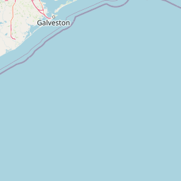
Use this park location map to pinpoint Flower Garden Banks National Marine Sanctuary in United States of America, understand its exact geographic position, and read its mapped placement within the surrounding landscape more clearly.

Pigeon | © OpenStreetMap contributors

Location context for Flower Garden Banks National Marine Sanctuary

Texas
Recorded earthquake history

Review Historical Seismic Activity Near Flower Garden Banks National Marine Sanctuary

Examine a comprehensive catalogue of recorded earthquakes associated by location with the Flower Garden Banks National Marine Sanctuary. This dataset, curated within MoriAtlas, allows for the detailed study of historical seismic events in the northwestern Gulf of Mexico through documented magnitude and distance metrics.

Flower Garden Banks Earthquake History

Catalogued events

1 event

Strongest magnitude

Magnitude 3.6

Most recent event

Oct 21, 2023

This history includes earthquakes recorded inside the park or within 50 km of its borders

Visualizing submerged salt dome reefs, coral habitats, and offshore marine environments

Flower Garden Banks National Marine Sanctuary Photos and Seafloor Landscapes

Examine high-resolution imagery showcasing the underwater terrain, coral formations, and marine habitats protected within Flower Garden Banks National Marine Sanctuary. Visual documentation reveals the distinct topography of offshore salt dome banks and the thriving ecological communities inhabiting these isolated Gulf of Mexico reefs.

Close-up underwater view of vibrant orange and yellow spiral-shaped Christmas tree worms emerging from a textured coral reef surface against a dark background.

Park atlas

Compare surrounding regional marine reserves and offshore protected habitats

Parks Near Flower Garden Banks National Marine Sanctuary and Related Marine Protected Areas

Browse other marine sanctuaries and protected areas located across the broader regional waters. Continuing into adjacent coastal habitats provides valuable context for comparing offshore reef ecosystems and marine conservation zones.
A pale, minimalist watercolor painting showing a soft green treeline and forest edge against a white background.
Protected landscapeTexas
254 km away#1 closest

Northwest

Sam Houston National Forest: Mapping the Piney Woods Protected Landscape

Regional Geography of East Texas Protected Lands

Sam Houston National Forest is a 163,000-acre protected area in East Texas characterized by loblolly and shortleaf pine ridges. The geography features an intricate network of creeks, hardwood bottomlands, and designated wilderness areas like Little Lake Creek. Framed by Lake Conroe and Lake Livingston, the forest offers a complex look at Gulf Coastal Plains topography and long-standing Piney Woods ecological restoration efforts.

Area
659.82 km²
Established
1936
Relief
Lowland
Climate
Subtropical
Nature reserveTexas
About 271 km away#2 closest

West

Mission-Aransas National Estuarine Research Reserve: A Texas Coastal Protected Landscape

Mapped estuarine habitats and regional coastal geography

Encompassing a unique mix of terrestrial and marine environments, Mission-Aransas National Estuarine Research Reserve stands as a significant protected corridor on the Texas Coast. The landscape features deep-water bays, sheltered seagrass meadows, and open coastal prairie, offering a clear view of how riverine processes shape the complex shoreline of the western Gulf of Mexico.

Relief
Lowland
Climate
Subtropical
Access
Easy access
Scope
Mixed
A soft, watercolor-style illustration of a landscape with rolling dunes, sparse grasses, and a lone yucca plant.
Protected landscapeTexas
About 330 km away#3 closest

West

Padre Island National Seashore: Protected Barrier Island Geography and Mapping

Coastal landscapes and hypersaline lagoon ecosystems in South Texas

Padre Island National Seashore serves as a critical protected landscape on the Texas Gulf Coast, characterized by seventy miles of undeveloped shoreline and the hypersaline Laguna Madre. This atlas entry provides geographic context on the barrier island terrain, including active dune fields, tidal flats, and the diverse habitats that support significant migratory bird populations and sea turtle recovery efforts.

Area
527.85 km²
Established
1962
IUCN
V
Visitors
573.3K annual
National parkLouisiana
About 383 km away#4 closest

North

Kisatchie National Forest: Geographic Overview and Protected Landscapes in Louisiana

Mapping the state's largest expanse of protected forest and pine ecosystems.

Spanning over 600,000 acres, Kisatchie National Forest stands as the primary protected natural landscape within Louisiana. Its terrain ranges from ancient upland pine formations and sandstone ridges to complex hardwood bottoms and cypress-tupelo swamps. This area serves as a vital anchor for regional biodiversity, protecting rare hillside seepage bogs and calcareous prairies that have largely vanished from the surrounding southern landscape.

Area
2,440 km²
Established
1930
Relief
Upland
Climate
Subtropical
Wildlife reserveLouisiana
386 km away#5 closest

North

Kisatchie Hills Wilderness: Exploring Louisiana's Rugged Backcountry Protected Landscapes

Upland forest geography and preserved ridge terrain in Louisiana.

Kisatchie Hills Wilderness serves as a rare example of elevated, rugged terrain in Louisiana, offering a protected backcountry environment far removed from coastal marshes. This area provides a specialized map of forest-clad hills, ravines, and clear stream crossings that define a unique regional geography for those tracing Louisiana's diverse natural features.

Area
35.21 km²
Established
1980
IUCN
Ib
Relief
Upland
Protected landscapeMississippi
425 km away#6 closest

Northeast

Homochitto National Forest: Mapping the Protected Landscapes of Southwestern Mississippi

Regional forest geography and landscape documentation.

Investigate the unique landscape of Homochitto National Forest, an extensive protected area in Mississippi defined by its loess-country topography and managed pine forests. This entry provides essential mapping context and geographic data for those examining the role of this forest within the broader Southeastern United States ecological network and its CCC-rooted heritage.

Area
776.34 km²
Established
1936
Relief
Upland
Scope
Terrestrial
Wildlife reserveTamaulipas
About 461 km away#7 closest

Southwest

Laguna Madre Wildlife Reserve: Geography and Protected Coastal Landscapes of Tamaulipas

Mapping the hypersaline lagoons and barrier island chains of Mexico

Laguna Madre represents a singular coastal ecosystem characterized by its extreme salinity, expansive seagrass meadows, and sheltered barrier island configuration. As a vital protected wetland, the area serves as a primary migratory flyway and habitat for diverse shorebirds and sea turtles, revealing a distinct arid coastal landscape along the Tamaulipas shore.

Area
5,728.08 km²
Established
2005
IUCN
VI
Relief
Lowland
A watercolor illustration of a coastal landscape with a sandy shoreline, soft green dunes, and a gentle pink horizon against a white background.
Protected landscapeFlorida
511 km away#8 closest

Northeast

Gulf Islands National Seashore: Mapped Landscapes and Protected Coastal Geography

Coastal terrain across Florida, Alabama, and Mississippi.

Spanning diverse units across the Gulf Coast, Gulf Islands National Seashore preserves dynamic barrier islands and mainland reserves. This geographic profile traces the quartz-sand beaches, maritime ecosystems, and historic defense networks that form this protected landscape, providing context on its unique geologic and environmental evolution.

Area
548.179 km²
Established
1971
IUCN
V
Visitors
8.3M annual

Common questions about visiting, size, designation, and location context for Flower Garden Banks National Marine Sanctuary

Flower Garden Banks National Marine Sanctuary FAQs for park facts, access, geography, and protected area context

Find quick answers about Flower Garden Banks National Marine Sanctuary, including protected-area facts, park geography, trail and visitor context, and how the park fits into its surrounding country and regional landscape.
MoriAtlas Explorer

Continue Your Protected Areas Search Across the Global Atlas

Deepen your exploration by continuing the structured search for national parks and protected areas worldwide. Utilize the comprehensive filtering capabilities to compare different conservation landscapes and refine your understanding of global park geography. Discover more about the distribution and characteristics of protected natural areas.

Global natural geography