

Mori Atlas logo
Protected areaFlyndersø

Examining the geographic boundaries and mapped terrain of a significant Danish heathland system

Flyndersø Protected Area and Heath Lake Landscape in Northwest Midtjylland, Denmark

Flyndersø stands as the largest heath lake in Denmark, defining the natural geography of the northwestern Midtjylland region. This protected landscape encompasses a bipartite basin system separated by the shallow Snævringen channel, surrounded by a mosaic of open heathland and conifer plantations. The area represents a vital conservation zone, integrating aquatic and terrestrial habitats within a formally protected Natura 2000 environment.

inland lakeheath lakeDanish lakeheathlandconifer plantationNatura 2000 site
A flat-style digital illustration showing a lake with cattails in the foreground, a forest on the left, and cliffs with a waterfall in the background under a pale sun.

Flyndersø

Protected area

Park overview

Structured park overview, official facts, and landscape profile for Flyndersø

Flyndersø park facts, protected area profile, and essential visitor context

Review the core facts for Flyndersø, including designation, size, terrain, visitor scale, habitats, and operating context in one park-focused overview.

About Flyndersø

Flyndersø is a substantial freshwater lake in west-central Jutland that functions as both a natural landscape feature and an ecological anchor for the surrounding area. Located near the southern edge of the Salling peninsula, between the towns of Skive and Vinderup, the lake lies in a region characterized by gently undulating terrain, open heaths, and patches of plantation forestry. This combination of open water and upland heath gives Flyndersø a distinctive visual and ecological identity that sets it apart from more forested Danish lake landscapes.

The lake itself covers roughly 418 hectares and is clearly bipartite: a larger northern basin and a smaller southern basin separated by Snævringen, a constricted channel that is only about a meter deep. This division creates two effectively distinct lake environments within a single named water body. Average depth across the lake is modest, at around 3.6 meters, and maximum depth reaches about 11 meters, giving Flyndersø the character of a broad, relatively shallow lake rather than a deep, steep-sided one.

Hydrologically, Flyndersø receives water from several streams, including Stubber Å from the south (which links it indirectly to Stubbergård Sø), as well as inflows from Hellesø and Skallesø on the western side. Groundwater makes up a significant share of the inflow. The lake drains via Koholm Å into Karup Å, from which its waters ultimately reach Skive Fjord. This role as a link in a wider fluvial system reinforces the lake's environmental importance beyond its immediate shoreline.

Surrounding the lake is a layered mosaic of protected and semi-natural landscapes. To the east lies Hjelm Hede, a broad heathland area; to the northwest sits Estvadgård Plantage; and to the west rises the heathland of Hjerl Hede, which harbors Denmark's well-known Hjerl Hede open-air museum. Together, lake, heaths, and plantations form the core of Natura 2000 site number 41 (Hjelm Hede, Flyndersø and Stubbergård Sø).

Quick facts and research context for Flyndersø

Flyndersø is located in west-central Jutland, Denmark, in the Midtjylland region, near the towns of Skive and Vinderup. It is classified as Denmark's largest heath lake (hedesø) and is divided into a northern basin of about 269 hectares and a southern basin of about 149 hectares, for a combined surface area of approximately 418 hectares. The lake has an average depth of roughly 3.6 meters and a maximum depth of about 11 meters, with a water volume of around 14.9 million cubic meters.

Flyndersø is part of Natura 2000 site number 41, designated as both a Habitat Area and a Bird Protection Area (H41 and F29). The broader protected complex of lake, heath, and plantation covers around 1,200 hectares, and most of these protected lands are owned by the Hjerl-Fonden foundation. The lake drains into Koholm Å, which flows into Karup Å and eventually into Skive Fjord.

Protection and recognition

Examine the terrestrial protection metrics and official designation records for Flyndersø.

Flyndersø Protection Status and Documented Conservation Scope

Terrestrial protection records for Flyndersø outline the documented conservation scope and administrative management parameters. Structured data compiles available designation history and recognition sources into a comprehensive territorial reference.

Protection details

Protection scope
Terrestrial
Transboundary protection
No
Park context

Deeper park guide and search-rich context for Flyndersø

Flyndersø history, landscape, wildlife, and travel context

Explore Flyndersø through its history, landscape character, ecosystems, wildlife, conservation priorities, cultural context, and seasonal travel timing in a structured park guide built for atlas discovery and search intent.

Why Flyndersø stands out

Flyndersø is best known as Denmark's largest heath lake, distinguished by its setting within a heathland-and-plantation landscape rather than a more typical forested catchment. Its character is shaped by the contrast between open heath, planted conifer stands, and a broad, shallow body of water that splits into two distinct basins connected by the narrow, very shallow Snævringen. The lake is also notable as the centerpiece of a sizable Natura 2000 site that combines lake, heath, and woodland interests, and sits adjacent to Hjerl Hede, a culturally significant open-air heritage museum. Together these qualities make Flyndersø a defining element of the heath-lake landscape of northwestern Midtjylland.
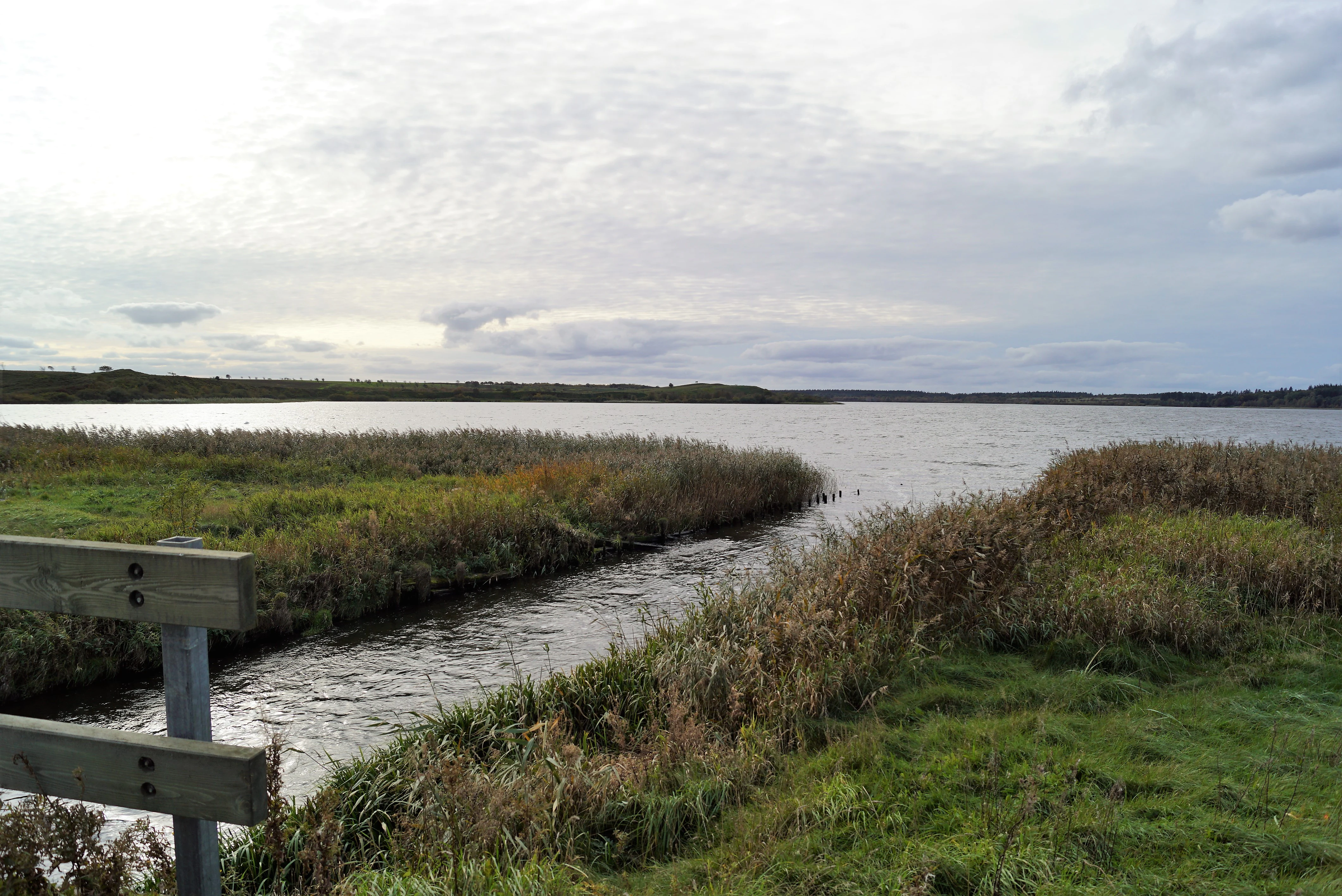
A wide, calm lake landscape under a cloudy sky, with a stream flowing out of the lake in the foreground and tall grasses along the banks.
The northern end of Flyndersø lake where it flows into the Koholm Å stream.

Flyndersø history and protected-area timeline

The protected status of the area around Flyndersø was secured in stages in the twentieth century, with formal nature conservation designations applied in 1934 and again in 1967. These designations collectively covered the lake and roughly 1,200 hectares of surrounding heathland and plantation.

The surrounding protected lands are predominantly owned by Hjerl-Fonden, the foundation that, until 1979, also operated the nearby Hjerl Hede open-air museum. Flyndersø's historical outflow was once located slightly south of the present-day Koholm Å, near a site associated with a former mill referred to as Flyndersø Mølle, hinting at a longer legacy of human use of the lake and its waters beyond modern conservation management.

Flyndersø landscape and geographic character

Flyndersø occupies a low-lying landscape typical of the western and northwestern Midtjylland region. The terrain around the lake is composed of gently rolling heath and plantation, with no dramatic relief, but with a clear visual rhythm of open heath, dark conifer stands, and shimmering open water. The defining physical feature of the lake itself is the constriction known as Snævringen, which divides Flyndersø into a larger northern basin and a smaller southern basin joined by a narrow, very shallow channel.

The wider landscape is shaped by heath. To the east of the lake lies Hjelm Hede, while to the northwest stretches Estvadgård Plantage. To the west rises Hjerl Hede, a heathland that hosts the open-air heritage museum of the same name and gives the region much of its character. The combination of broad lake surface, surrounding heath, and patterned plantation woodland defines Flyndersø's visual identity.
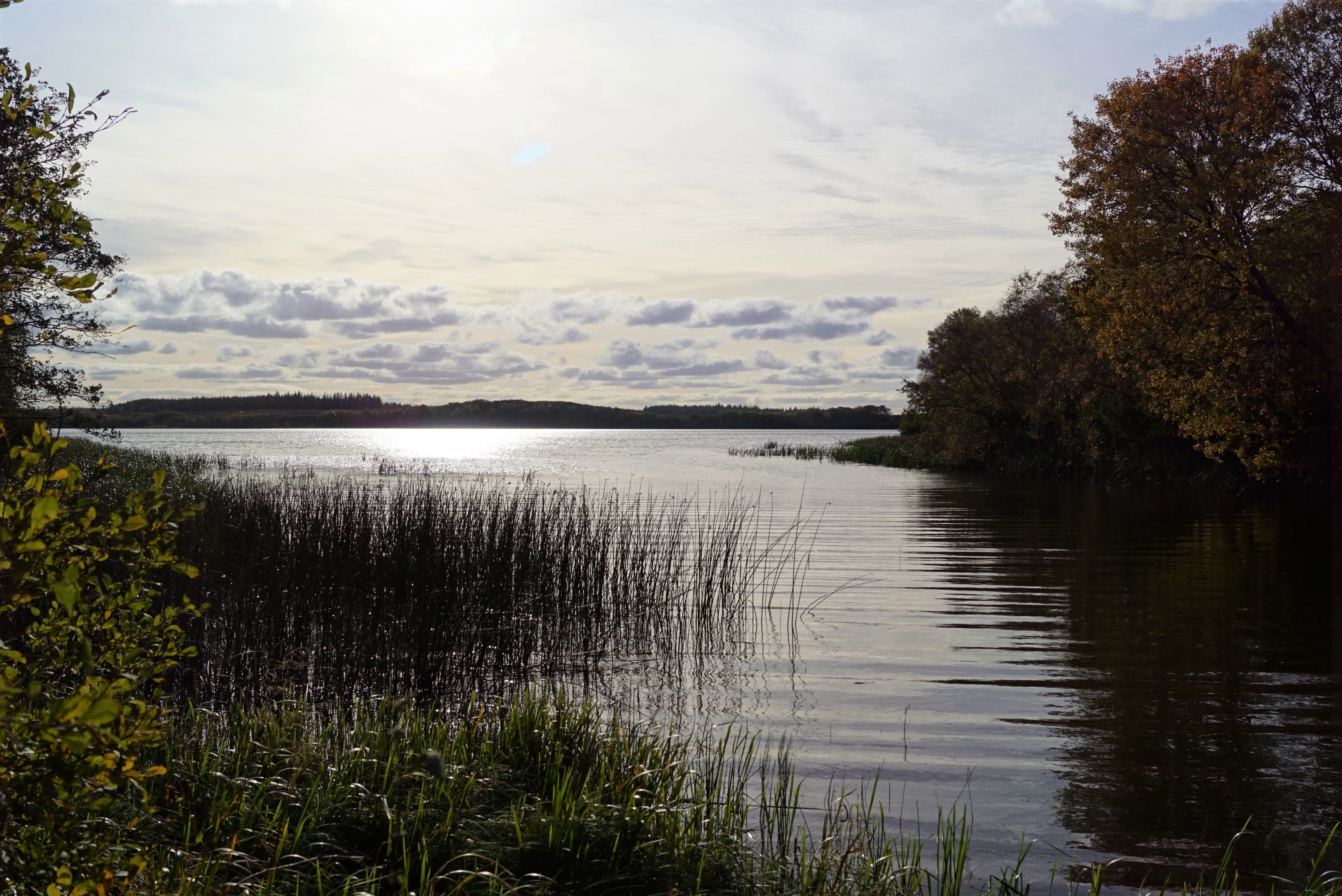
A wide view of a calm lake surrounded by trees and reeds under a bright, cloudy sky.
A view of the Flyndersø lake looking south from the Snaevringen area.

Flyndersø ecosystems, habitats, and plant life

Ecologically, Flyndersø sits at the intersection of two distinct but interconnected Danish habitat types: open, acidic heathland and freshwater lake habitat. The surrounding mosaic of dry heath, plantation conifer stands, and the lake itself supports a range of plant communities adapted to nutrient-poor, sandy substrates and to open-water conditions.

The lake's hydrological inputs are diverse. Surface inflow comes from several streams, including Stubber Å from the south and unnamed channels from Hellesø and Skallesø to the west, while groundwater contributes a substantial share of the inflow. This mix of stream and groundwater sources influences the lake's character, supporting both aquatic and fringing wetland communities.

Beyond the shoreline, the heathlands of Hjelm Hede to the east and Hjerl Hede to the west add dry, low-nutrient terrestrial habitats typical of Jutland's classic heath landscapes. Plantations such as Estvadgård Plantage to the northwest introduce a wooded component, creating transitional zones between open heath, plantation, and lake margin.

Flyndersø wildlife and species highlights

Flyndersø and its surrounding lands are designated both as a Habitat Area and as a Bird Protection Area under the Natura 2000 framework, reflecting the importance of the lake for waterbirds and wetland-associated species as well as of the surrounding heath for characteristic heathland fauna.

The combination of open water, fringing wetland margins, dry heath, and plantation provides a varied habitat mosaic that supports both aquatic birds and terrestrial heathland species. The lake's large surface area, relative shallowness, and connection to broader networks of open water and semi-natural land make it a meaningful site for migratory and breeding waterbirds within inland Jutland.

Flyndersø conservation status and protection priorities

Flyndersø is the ecological centerpiece of Natura 2000 site number 41, known formally as Hjelm Hede, Flyndersø and Stubbergård Sø. The site carries both Habitat Area and Bird Protection Area designations (H41 and F29), indicating that it has been recognized for its importance both to habitat types listed under the EU Habitats Directive and to bird species protected under the Birds Directive.

The protected landscape extends well beyond the water itself. Roughly 1,200 hectares of lake, heath, and plantation around Flyndersø were placed under formal nature protection in 1934 and again in 1967. Most of the protected land is owned and managed by Hjerl-Fonden, a foundation that has also played a central cultural role in the region through its long stewardship of the Hjerl Hede open-air museum until 1979. Together, these conservation and ownership patterns ensure that Flyndersø is sustained as a protected inland landscape rather than only as an unprotected fishing or recreational water body.

Flyndersø cultural meaning and human context

The cultural context of Flyndersø is inseparable from Hjerl Hede, the historic heathland open-air museum that lies just west of the lake's southern basin. Hjerl-Fonden, which owns most of the surrounding protected lands, operated this museum until 1979, linking the conservation of the heath and lake with the preservation of traditional Danish rural culture and built heritage.

A subtle but telling human trace remains in the landscape in the form of a former lake outflow near Flyndersø Mølle, slightly south of the present-day Koholm Å outlet, suggesting that the lake and its waters have been used and modified by local communities over multiple generations. This embedded human history gives the area around Flyndersø a layered identity as both a natural and a cultural landscape.

Top sights and standout views in Flyndersø

Flyndersø is distinguished above all by being Denmark's largest heath lake, a status that anchors both its identity and its conservation significance. The lake's bipartite structure, split by the very shallow Snævringen into a 269-hectare northern basin and a 149-hectare southern basin, gives it a distinctive visible form.

Surrounding the lake is a large, formally protected landscape of heath and plantations: Hjelm Hede to the east, Hjerl Hede with its open-air museum to the west, and Estvadgård Plantage to the northwest. The presence of Natura 2000 designations as both a Habitat Area and a Bird Protection Area, combined with the long-standing ownership role of Hjerl-Fonden, makes it a flagship site for inland conservation in northwest Midtjylland.

Best time to visit Flyndersø

Flyndersø is shaped strongly by the seasonal rhythm of the surrounding heathlands and the mood of the Jutland inland climate. Late spring and summer typically bring the most active birdlife around the lake margins and adjacent heaths, when heath species are breeding and waterbird activity on the lake is at its peak, while also offering the longest daylight for walking the heath edges.

Autumn and winter change the atmosphere of the area considerably, with cooler, often misty conditions over the open water and the heathland taking on quieter, more subdued character. These quieter seasons can also emphasize the openness of the landscape and the contrast between heath, plantation, and open lake. Visitors interested in specific bird or flowering events should consult current local guidance, as natural cycles vary year to year.

Monthly climate preview

Track multi-year monthly averages and measured annual weather rhythms across Flyndersø coordinates.

Flyndersø Climate Normals: Long-Term Temperature and Precipitation Patterns

Long-term data records for Flyndersø document measured shifts in average monthly temperatures and precipitation rates from representative sample points. Detailed monthly climate profiles provide complete twelve-month breakdowns for deep geographic analysis.
Annual mean8 °C
1 °C17 °C
Jan
Feb
Mar
Apr
May11°
Jun14°
Jul17°
Aug17°
Sep14°
Oct
Nov
Dec
Warmest month
August

16.7 °C

Coolest month
February

1.2 °C

Wettest month
October

3.2 mm/day

Driest month
April

1.7 mm/day

Park location guide

Geography guide, regional context, and park location map for Flyndersø

Flyndersø park geography, regions, and map view in Denmark

Understand where Flyndersø sits in Denmark through a broader geographic reading of the surrounding landscape, nearby location context, and its mapped position within the national park landscape.

How Flyndersø fits into Denmark

Denmark is a constitutional monarchy and Nordic country in Northern Europe. It is the southernmost of the Scandinavian countries, bordering Germany to the south, Norway to the north, and Sweden to the southwest. The country consists of the Jutland peninsula and an archipelago of islands, with Copenhagen as its capital and largest city. Denmark has a population of over 6 million and is characterized by flat, arable land, sandy coasts, and a temperate climate.

Wider geography shaping Flyndersø in Denmark

Denmark occupies the Jutland peninsula and roughly 406 islands in Northern Europe. It is situated between the North Sea to the west and the Baltic Sea to the east. The country borders Germany to the south and is connected to Sweden via the Øresund Bridge. Denmark is predominantly flat terrain with low elevation, the highest point being Møllehøj at 170.86 meters.

Map view of Flyndersø

Use this park location map to pinpoint Flyndersø in Denmark, understand its exact geographic position, and read its mapped placement within the surrounding landscape more clearly.

Pigeon | © OpenStreetMap contributors

Location context for Flyndersø

Midtjylland

Examine the terrain, heathland habitats, and protected freshwater environment of Denmark's largest heath lake through detailed imagery.

Flyndersø Photos and Landscape Scenery Visual Explorer

Visual records capture the open waters, surrounding heathlands, and conifer plantations that define the terrain of Flyndersø. Detailed photography reveals the protected habitats and regional scenery, offering a clear visual reference for the landscape character of this protected freshwater basin.

A wide, calm lake landscape under a cloudy sky, with a stream flowing out of the lake in the foreground and tall grasses along the banks.

A peaceful lake surrounded by a dense green forest and reeds, under a blue sky with soft white clouds.

A wide view of a calm lake surrounded by trees and reeds under a bright, cloudy sky.

Park atlas

Compare regional wetland reserves and neighboring heathland landscapes

Explore Protected Areas and Parks Near Flyndersø in Central Jutland

Browse other protected areas and regional nature reserves surrounding Flyndersø to examine broader habitat patterns across Midtjylland. Continuing the geographic comparison reveals connected wetland networks and similar low-lying conservation zones throughout the surrounding region.
A horizontal watercolor painting depicting a soft, impressionistic landscape of a still lake surrounded by low, rolling hills, grassy banks, and scattered greenery.
Protected areaRegion Midtjylland
About 1.8 km away#1 closest

Southwest

Natura 2000-område nr. 41 Hjelm Hede, Flyndersø og Stubbergård Sø Protected Landscapes

Glacial tunnel valleys and heathlands in Region Midtjylland

Situated in Region Midtjylland, this area serves as a significant site for observing post-glacial landscape formation. The territory features a layered geological sequence, combining dead-ice lakes, open heath plains, and sheltered deciduous woodlands within a designated bird protection zone.

Area
21.7 km²
Established
2011
Relief
Lowland
Climate
Temperate
Protected areaMidtjylland
About 2.1 km away#2 closest

West

Skallesø Protected Area: Mapping the Lakes and Heathlands of Central Jutland

Aquatic habitats, historic heath, and inland river connectivity.

Skallesø represents a focal point for inland conservation in central Jutland. This detailed entry maps its unique basin and its integration into the Hjerl Hede cultural landscape. Study the lake's ecological margins, its bird-protection status, and the hydrologic link provided by the Hindså to the wider river network, showcasing a century of dedicated conservation efforts.

Area
0.737 km²
Relief
Lowland
Scope
Terrestrial
Water
Water-dominated
Nature reserveRegion Midtjylland
About 3.8 km away#3 closest

Northwest

Skånsø og Tranemose Nature Reserve: Geographic Profile and Protected Area Context

Mapped habitats in the Central Jutland region of Denmark

The Skånsø og Tranemose nature reserve showcases the interplay of glacial landforms and historical land use. Situated in Region Midtjylland, this area serves as a significant protected site where visitors can examine the geography of Lobelia-rich clear lakes alongside the brown-water remnants of an exploited raised bog. The site provides essential ecological structure within its broader plantation environment.

Area
0.84 km²
Established
2011
Relief
Lowland
Scope
Terrestrial
Protected areaRegion Midtjylland
About 5.9 km away#4 closest

Northwest

Skørsø Protected Area: Mapped Geography and Habitat Context in Region Midtjylland

Natural glacial basin and rare aquatic ecosystem in Central Denmark

The Skørsø site offers a detailed look at a rare clearwater, nutrient-poor lake basin formed by post-glacial processes. The protected area features a unique, unfragmented transition between open water and wet heath vegetation, serving as a critical refuge for specialized flora and protected wildlife within the cultivated landscape of Denmark.

Area
0.12 km²
Established
2011
Water
Major water bodies
Protected areaRegion Midtjylland
About 17 km away#5 closest

West

Natura 2000-område nr. 62 Veno, Veno Sund: Protected Coastal and Marine Landscape Map

Regional geography and protected coastal habitat overview

Analyze the protected area characteristics of Natura 2000-område nr. 62 Veno, Veno Sund, where shallow brackish sound meets dune heaths and calcareous grasslands. This site provides essential habitat for waders and marine mammals within the broader Limfjorden ecosystem in Region Midtjylland.

Area
29.26 km²
Established
2011
Relief
Lowland
Climate
Temperate
Nature reserveRegion Midtjylland
About 19 km away#6 closest

South

Sønder Feldborg Plantage Nature Reserve: Geographic Overview and Protected Landscapes

Heath, mire, and lake habitats in Region Midtjylland

Sønder Feldborg Plantage preserves a rare assembly of central Jutland habitats, spanning hanging bog, brown-water lakes, and heath mosaics. This protected area stands as a primary example of peatland restoration and conservation within the larger plantation landscape, offering a dense concentration of rare Danish ecological features in a 120-hectare site.

Area
1.2 km²
Established
2011
Relief
Lowland
Water
Minor water
Protected areaDenmark
About 22 km away#7 closest

Northwest

Nissum Bredning Protected Area: Geography and Coastal Mapping in Denmark

Shallow bay ecosystems, glacial cliffs, and Limfjorden sand flats.

Nissum Bredning is a broad, low-lying basin in western Denmark known for its extensive shallow sand flats, including Fjordgrund and Gåseholm. The protected area encompasses a diverse coastal mosaic of brackish lagoons, salt meadows, and the distinctive Toftum Bjerge glacial cliff. This geography offers a clear view into the intersection of active North Sea currents and sheltered inland fjord environments.

Area
200 km²
Relief
Lowland
Climate
Temperate
Access
Easy access
Nature reserveCentral Denmark Region
About 23 km away#8 closest

East

Natura 2000-område nr. 39 Mønsted og Daugbjerg Kalkgruber og Mønsted Ådal Geography and Map

Subterranean chalk mines and river valley ecosystems in Central Denmark

This protected area offers a look at a varied mosaic of habitats in central Jutland, spanning steep valley slopes, heath plateaus, and historic subterranean chalk mine complexes. The region acts as a vital habitat for bat species and rare moss flora, defined by its groundwater-fed spring mires and the pristine waters of Birkesø lake.

Area
7.4 km²
Established
2011
Relief
Lowland
Scope
Terrestrial

Common questions about visiting, size, designation, and location context for Flyndersø

Flyndersø FAQs for park facts, access, geography, and protected area context

Find quick answers about Flyndersø, including protected-area facts, park geography, trail and visitor context, and how the park fits into its surrounding country and regional landscape.
MoriAtlas Explorer

Continue Your Protected Areas Search Across the Global Atlas

Deepen your exploration by continuing the structured search for national parks and protected areas worldwide. Utilize the comprehensive filtering capabilities to compare different conservation landscapes and refine your understanding of global park geography. Discover more about the distribution and characteristics of protected natural areas.

Global natural geography