Mori Atlas logo
Nature reserveFogg Dam Conservation Reserve

An examination of monsoonal floodplain dynamics, paperbark woodland corridors, and seasonal water patterns.

Fogg Dam Conservation Reserve: Mapped Protected Landscapes and Northern Territory Wetland Geography

Fogg Dam Conservation Reserve represents a vital wetland protected area situated within the expansive floodplains of the Northern Territory. This atlas entry details the mosaic of grassed shallows, lily-covered margins, and paperbark forests that define its monsoonal ecosystem. Through focused geographic data, understand how seasonal flood cycles shape this critical habitat for diverse waterbird and reptile populations.

wetlandfloodplainbirdwatchingwaterbirdscrocodilesmonsoonal ecosystem

Fogg Dam Conservation Reserve

Nature reserve

Park overview

Structured park overview, official facts, and landscape profile for Fogg Dam Conservation Reserve

Fogg Dam Conservation Reserve park facts, protected area profile, and essential visitor context

Review the core facts for Fogg Dam Conservation Reserve, including designation, size, terrain, visitor scale, habitats, and operating context in one park-focused overview.

About Fogg Dam Conservation Reserve

Fogg Dam Conservation Reserve occupies a stretch of low-lying floodplain country on the coastal plain of the Northern Territory, roughly 70 kilometers east of Darwin near the community of Middle Point. The reserve sits within the much larger Adelaide and Mary River Floodplains, a system recognized as an Important Bird Area for its role in supporting vast numbers of waterbirds, particularly during the tropical wet season and the subsequent Build-Up period. At its heart is a shallow, seasonally inundated landscape shaped by monsoonal rains and the gradual retreat of floodwaters. Rather than a single uniform wetland, Fogg Dam is a mosaic of habitats that change character through the year. In the wet season, broad, shallow sheets of water cover much of the floodplain, while the surrounding paperbark woodlands fringe the inundated zones. As the dry season progresses, water contracts into discrete open-water areas, grassed shallows, and lily-covered margins, concentrating wildlife and creating exceptional viewing conditions. Several raised observation platforms have been established to make this seasonal drama accessible to visitors without disturbing the wildlife. The reserve is particularly important in an Australian conservation context because it represents a relatively intact example of tropical floodplain wetland ecology in close proximity to a major capital city. Its position within an Important Bird Area places it alongside other nationally significant wetlands of the Top End, while its high reptile diversity adds an additional layer of ecological distinction. For travelers arriving in Darwin, Fogg Dam offers a compact but intense introduction to the seasonal rhythms and biological richness of northern Australia.

Quick facts and research context for Fogg Dam Conservation Reserve

Protected wetland reserve located near Middle Point in the Northern Territory of Australia, within the broader Adelaide and Mary River Floodplains system. Established in 1982 and managed by the Parks and Wildlife Commission of the Northern Territory, the reserve is classified as an IUCN Category V protected landscape. It covers roughly 37 square kilometers of floodplain habitat and forms part of a recognized Important Bird Area.

Protection and recognition

Documented terrestrial protection scope and conservation management records

Fogg Dam Conservation Reserve Protection Status and Recognized Designations

Fogg Dam Conservation Reserve maintains a defined terrestrial protection scope within its designated landscape boundary. Structured records outline the formal management framework and official conservation status associated with the protected area.

Protection details

Protection scope
Terrestrial
Transboundary protection
No
Park context

Deeper park guide and search-rich context for Fogg Dam Conservation Reserve

Fogg Dam Conservation Reserve history, landscape, wildlife, and travel context

Explore Fogg Dam Conservation Reserve through its history, landscape character, ecosystems, wildlife, conservation priorities, cultural context, and seasonal travel timing in a structured park guide built for atlas discovery and search intent.

Why Fogg Dam Conservation Reserve stands out

Fogg Dam is best known as a premier Top End birdwatching destination, especially for magpie geese, egrets, spoonbills, ibises, whistling ducks, and jacanas that use its mosaic of open water, grassed shallows, and lily-covered margins. It is equally famous for its reptile populations, including saltwater and freshwater crocodiles and Australia's reportedly largest snake concentrations, with species such as water pythons and death adders. The reserve also stands out as a vivid example of monsoonal floodplain ecology, where the wet and dry seasons transform the landscape from expansive sheetwater to a contracting patchwork of drying pools and paperbark woodland.
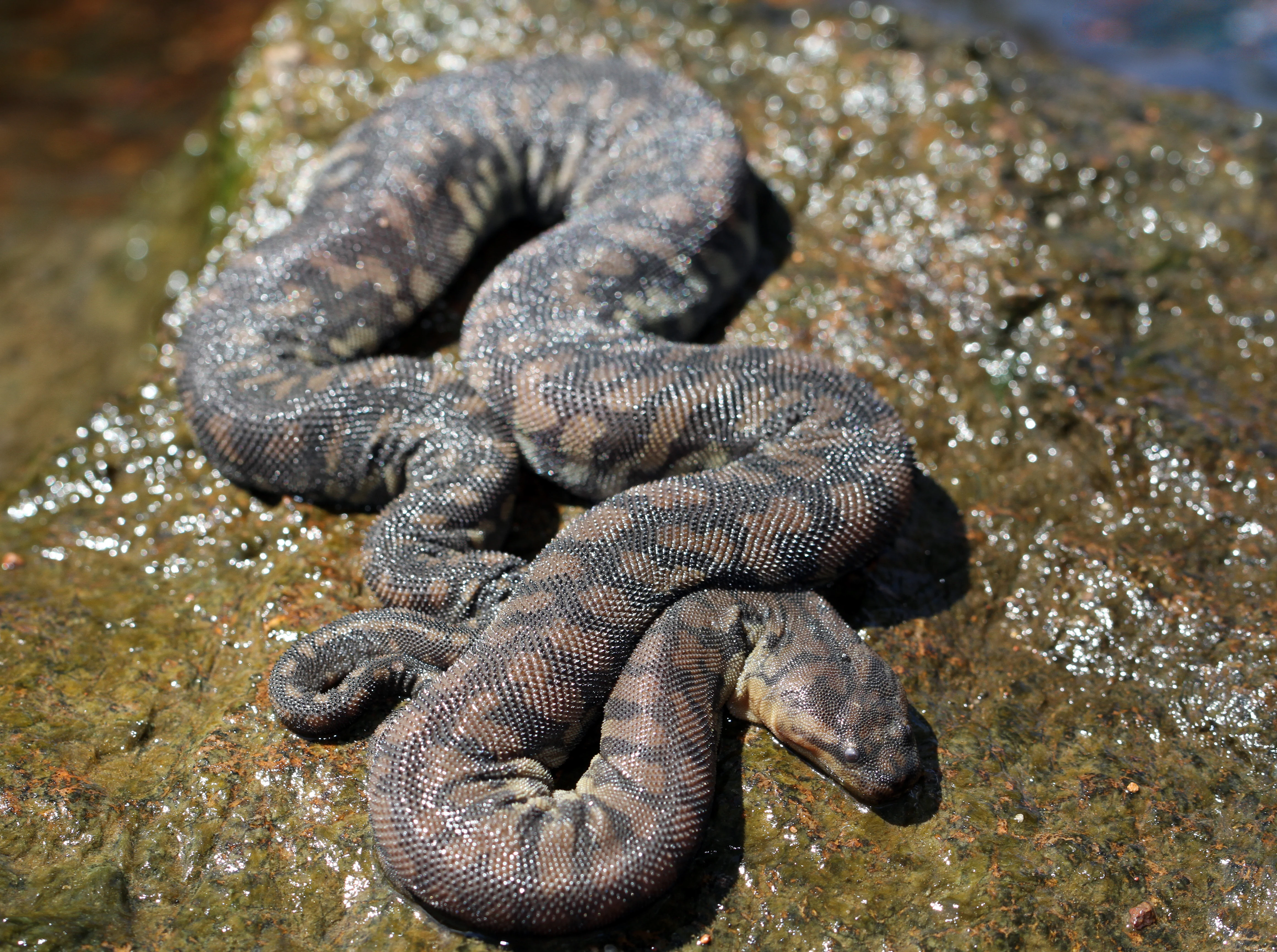
A close-up of a coiled Arafura file snake with dark, patterned, bumpy skin resting on a wet, algae-covered rock.
An Arafura file snake resting on a rock, a species commonly found in the wetlands of Fogg Dam.

Fogg Dam Conservation Reserve history and protected-area timeline

Fogg Dam Conservation Reserve was formally established on 13 August 1982, creating a dedicated protected area around a section of the Adelaide and Mary River floodplain east of Darwin. The reserve has since been managed by the Parks and Wildlife Commission of the Northern Territory as a Category V protected landscape. Its development as a conservation site reflects a broader recognition during the late twentieth century that the wetlands east of Darwin were of exceptional value for waterbirds, particularly migratory and wetland-dependent species that rely on the monsoonal flood pulse. Over time, the site was integrated into the larger Adelaide and Mary River Floodplains Important Bird Area framework, which elevated its national and international profile for bird conservation. Observation platforms and interpretive signage were progressively introduced to manage visitor access while concentrating wildlife viewing in low-impact locations.

Fogg Dam Conservation Reserve landscape and geographic character

The physical landscape of Fogg Dam is a flat, low-lying tropical floodplain, defined less by dramatic topography than by subtle shifts between water, vegetation, and exposed mud. During the wet season, the area spreads into broad shallow inundations, with sheets of water stretching between scattered trees and islands of higher ground. As floodwaters recede, the landscape reorganizes into distinct zones of open water, grassed shallows, lily-filled margins, and fringing paperbark woodland. This habitat mosaic is the defining feature of the reserve. The transitional edges between deeper water and drying grassland are especially dynamic, attracting the highest densities of birds and reptiles. Raised observation platforms are set above the floodplain so visitors can look out over this shifting patchwork without disturbing the wildlife that depends on it.

Fogg Dam Conservation Reserve ecosystems, habitats, and plant life

Ecologically, Fogg Dam sits within the wet-dry tropical climatic zone of northern Australia, where seasonal flooding drives almost every ecological process in the floodplain. The reserve's habitats include open water, grassed shallows, lily-covered shallows, fringing paperbark forest, and seasonally exposed mudflats. Each habitat supports a different suite of species, and the proximity of these habitats to one another is a key part of the reserve's ecological richness. Because the floodplain contracts and expands on a strong seasonal cycle, the reserve alternates between phases of dispersal, when water spreads widely and wildlife is thinly distributed, and phases of concentration, when retreating water draws birds, reptiles, and other animals into smaller and smaller areas. This pulse is what gives Fogg Dam its distinctive ecological character and its importance for waterbird populations across the Adelaide and Mary River Floodplains.

Fogg Dam Conservation Reserve wildlife and species highlights

Fogg Dam is renowned for its dense and visible wildlife, particularly waterbirds and reptiles. The reserve attracts large numbers of magpie geese, whistling ducks, egrets, herons, ibises, spoonbills, jacanas, cormorants, pelicans, and raptors such as the white-bellied sea eagle and whistling kite. The fringing paperbark woodlands host additional species including rainbow bee-eaters, forest kingfishers, honeyeaters, and the distinctive yellow chat. The reptile fauna is equally notable. Both saltwater and freshwater crocodiles are present year-round, and the reserve is widely cited for hosting one of the highest concentrations of snakes recorded anywhere in Australia, including water pythons, death adders, and the Arafura file snake. Wallabies and other tropical savanna mammals also occur in the broader landscape, though the wetland's birdlife and reptiles tend to dominate the visitor experience.

Fogg Dam Conservation Reserve conservation status and protection priorities

Fogg Dam's protected status preserves a representative example of monsoonal floodplain wetland ecology in close proximity to a Northern Territory capital. Its inclusion within the Adelaide and Mary River Floodplains Important Bird Area gives it recognition at a national and international scale for the conservation of waterbirds, especially migratory and wetland-dependent species. The reserve also contributes to broader floodplain conservation by maintaining habitat heterogeneity across seasonally inundated and dry-phase conditions. Its elevated boardwalks and observation platforms concentrate visitor use in a way that helps protect sensitive nesting, feeding, and basking areas from widespread trampling. The combination of formal protected status, strategic landscape placement within a recognized Important Bird Area, and accessibility for low-impact public use makes Fogg Dam a meaningful component of the Northern Territory's conservation network.

Fogg Dam Conservation Reserve cultural meaning and human context

Fogg Dam lies in the traditional country of Aboriginal peoples of the Adelaide and Mary River floodplains, a landscape that has longsupported local communities through fishing, hunting, and seasonal use of wetland resources. While the reserve is primarily framed as a wildlife and conservation site, it sits within a broader Top End cultural landscape in which floodplains, billabongs, and paperbark forests are deeply embedded in regional identity and ecological knowledge. Interpretive signage and visitor information highlight the area's natural values, while the reserve's proximity to Darwin and the rural community of Humpty Doo ties it into the everyday life and travel patterns of the Northern Territory.

Top sights and standout views in Fogg Dam Conservation Reserve

Fogg Dam's standout qualities are its habitat diversity within a compact area, the seasonal concentration of waterbirds along receding floodwaters, and the unusually high density of reptiles, including year-round crocodiles and one of Australia's most concentrated snake populations. The reserve's raised observation platforms make these seasonal spectacles exceptionally accessible for short visits from Darwin, while its setting within the Adelaide and Mary River Floodplains Important Bird Area reinforces its national conservation significance.

Best time to visit Fogg Dam Conservation Reserve

Fogg Dam is most rewarding when floodwaters are receding rather than at peak inundation, because concentrating wildlife along shrinking pools, drying shallows, and exposed mudflats makes large numbers of birds and reptiles easier to see. In the Top End, this typically corresponds with the late wet season and the Build-Up period that follows, when water is high enough to support waterbird flocks but is starting to withdraw from the floodplain margins. The dry season offers drier, cooler, and more comfortable conditions and clearer vehicle access along the reserve's tracks, with wildlife grouped around remaining waterbodies. The wet season brings the largest expanses of water and dramatic skies, but also more heat, humidity, and mosquitoes. Year-round, both saltwater and freshwater crocodiles are present, and any visit should be planned with their activity in mind.

Monthly climate preview

Long-term representative point measurements tracking monthly temperature and precipitation variation

Fogg Dam Conservation Reserve Climate Normals and Annual Temperature Rhythm

Fogg Dam Conservation Reserve records sustained high monthly mean temperatures alongside distinct shifts in long-term average precipitation across the representative point. Detailed month-by-month climate normals illuminate the complete annual rhythm of temperature ranges and daily rainfall measurements.
Annual mean28 °C
25 °C31 °C
Jan28°
Feb28°
Mar27°
Apr27°
May26°
Jun25°
Jul26°
Aug27°
Sep30°
Oct31°
Nov30°
Dec29°
Warmest month
October

30.7 °C

Coolest month
June

25.1 °C

Wettest month
January

12.9 mm/day

Driest month
July

0 mm/day

Park location guide

Geography guide, regional context, and park location map for Fogg Dam Conservation Reserve

Fogg Dam Conservation Reserve park geography, regions, and map view in Australia

Understand where Fogg Dam Conservation Reserve sits in Australia through a broader geographic reading of the surrounding landscape, nearby location context, and its mapped position within the national park landscape.

How Fogg Dam Conservation Reserve fits into Australia

Australia is a constitutional monarchy and federal parliamentary democracy comprising six states and ten territories. With a population of nearly 28 million, it is one of the world's most urbanised countries, with most people concentrated on the eastern seaboard. The country has a high Human Development Index and is known for its cultural diversity, ancient Aboriginal heritage, and unique wildlife.

Wider geography shaping Fogg Dam Conservation Reserve in Australia

Australia occupies the entire Australian continent, the island of Tasmania, and numerous smaller islands. It is the world's flattest and driest inhabited continent, featuring vast deserts in the interior (the Outback), tropical rainforests along the eastern coast, and a coastline bordering the Indian and Pacific Oceans.

Map view of Fogg Dam Conservation Reserve

Use this park location map to pinpoint Fogg Dam Conservation Reserve in Australia, understand its exact geographic position, and read its mapped placement within the surrounding landscape more clearly.

Pigeon | © OpenStreetMap contributors

Location context for Fogg Dam Conservation Reserve

Northern Territory

Visualizing the floodplain terrain, monsoonal habitats, and protected scenery

Fogg Dam Conservation Reserve Photos and Wetland Landscapes

Visual records capture the shifting mosaic of open water, grassed shallows, and paperbark forests defining Fogg Dam Conservation Reserve. Examining these protected area images reveals the complex topography and seasonal ecology shaping the northern wetland environment.

A close-up of a coiled Arafura file snake with dark, patterned, bumpy skin resting on a wet, algae-covered rock.

A wide landscape view of flat green wetlands under a dark and heavy storm cloud with visible rainfall curtains.

Park atlas

Compare regional wetland reserves and surrounding monsoonal floodplain geography.

Explore Protected Areas and Other Parks Near Fogg Dam Conservation Reserve

Continue browsing nearby national parks and protected areas sharing the distinctive lowland tropical ecology of the region. Broadening the geographic comparison reveals connected wetland habitats and regional conservation landscapes across the surrounding terrain.
Watercolor illustration of a landscape with trees, open fields, and distant hills.
National parkNorthern Territory
About 8.1 km away#1 closest

East

Djukbinj National Park: Protected Landscape and Geographic Atlas Entry for Northern Territory

Mapped boundaries and regional landscape context for Djukbinj National Park.

Delve into Djukbinj National Park, a designated national park situated within the extensive Northern Territory of Australia. This entry provides an atlas-style examination of the park, highlighting its protected landscape features and geographic positioning. Discover detailed information on its mapped boundaries and how it contributes to the overall regional geography and natural terrain of Northern Australia, offering a unique lens for protected-area exploration.

Area
554.41 km²
Established
1997
IUCN
II
Climate
Tropical
Wildlife reserveNorthern Territory
About 14 km away#2 closest

Northwest

Black Jungle Conservation Reserve: Map, Geography, and Protected Landscape Context

Protected tropical savanna and floodplain wetlands in Northern Territory

Situated in the Northern Territory, Black Jungle Conservation Reserve preserves an essential link within the Adelaide River Coastal Floodplain. This wildlife reserve features rare spring-fed monsoon rainforests set against a backdrop of open eucalypt savanna, providing a protected sanctuary for internationally significant waterbird populations and saltwater crocodiles within a complex mosaic of tidal and seasonal wetlands.

Area
49.51 km²
Established
1986
IUCN
VI
Relief
Lowland
Nature reserveNorthern Territory
About 29 km away#3 closest

Northwest

Howard Springs Nature Park: Protected Landscape Maps and Regional Geography in Northern Territory

Detailed overview of tropical springs and monsoon forest terrain.

Howard Springs Nature Park offers a concentrated look at the unique Top End landscape through its permanent freshwater springs and bordering paperbark wetlands. Located near Darwin, this reserve provides essential habitat for waterfowl and serves as a primary example of protected inland spring systems within the Australian Northern Territory geography.

Area
2.86 km²
Established
1952
IUCN
V
Relief
Lowland
Wildlife reserveNorthern Territory
About 30 km away#4 closest

Northwest

Howard Springs Hunting Reserve: Mapped Protected Landscape and Regional Geography

Wildlife reserve terrain within the Howard Sand Plains

Howard Springs Hunting Reserve is a specifically managed wildlife reserve in Australia's Northern Territory, positioned within the Howard Sand Plains. This area serves as a vital component of a larger interconnected landscape that flows from inland wetlands toward the Shoal Bay coastal environment. Providing a unique look at sustainable-use protected lands, this resource offers geographic insights into how the reserve interacts with adjacent conservation corridors in the Darwin region.

Area
16.05 km²
Established
1984
IUCN
VI
Relief
Lowland
National parkNorthern Territory
About 31 km away#5 closest

East

Mary River National Park: National Park in Northern Territory, Australia

Mapped protected landscape and regional geographic context.

Mary River National Park is an officially designated national park located in the vast Northern Territory of Australia. This protected area offers rich opportunities for geographic discovery, allowing users to explore its mapped boundaries and understand its significance within the regional landscape. Discover the natural context and atlas positioning of Mary River National Park, contributing to a broader understanding of protected lands in Northern Australia.

Area
1,215.25 km²
Established
1966
IUCN
II
Visitors
336.4K annual
Protected areaNorthern Territory
About 31 km away#6 closest

Northwest

Shoal Bay Coastal Reserve Protected Landscape Mapping and Geographic Context

Coastal wetlands and eucalypt woodland in Northern Territory

Shoal Bay Coastal Reserve protects an expansive coastal fringe characterized by large tidal mud-flats and surrounding saline wetlands. This Northern Territory site offers a complex landscape where monsoon vine forests and woodland-covered uplands meet tidal substrates, providing significant habitat for migratory waterbirds.

Area
123 km²
Established
2000
IUCN
VI
Relief
Lowland
A soft watercolor painting showing a pinkish lagoon surrounded by green vegetation and rolling hills in the distance.
Wildlife reserveNorthern Territory
About 41 km away#7 closest

West

Knuckey Lagoons Conservation Reserve: Geographic Profile and Protected Wetland Map

Tropical lagoon habitat within the Northern Territory landscape

This wildlife reserve preserves an essential tropical lagoon and wetland environment on the suburban edge of Darwin. Established in 1966, it maintains a fragment of the seasonal coastal plain character within a heavily developed corridor, serving as an important case for localized habitat management in the Northern Territory.

Area
1.25 km²
Established
1966
IUCN
IV
Relief
Lowland
Wildlife reserveNorthern Territory
About 43 km away#8 closest

Southwest

Blackmore River Conservation Reserve: Protected Riverine Geography in the Northern Territory

A tropical riparian conservation corridor near Darwin

Blackmore River Conservation Reserve features a distinct 6.5-kilometre river corridor that shelters threatened plant species within the Northern Territory. This protected area offers insight into tropical riparian ecology, showcasing the transition between lush watercourse vegetation and surrounding woodland in the Darwin hinterland.

Area
5.47 km²
Established
1984
IUCN
V
Relief
Lowland

Common questions about visiting, size, designation, and location context for Fogg Dam Conservation Reserve

Fogg Dam Conservation Reserve FAQs for park facts, access, geography, and protected area context

Find quick answers about Fogg Dam Conservation Reserve, including protected-area facts, park geography, trail and visitor context, and how the park fits into its surrounding country and regional landscape.
MoriAtlas Explorer

Continue Your Protected Areas Search Across the Global Atlas

Deepen your exploration by continuing the structured search for national parks and protected areas worldwide. Utilize the comprehensive filtering capabilities to compare different conservation landscapes and refine your understanding of global park geography. Discover more about the distribution and characteristics of protected natural areas.

Global natural geography